Cold Becoming Colder

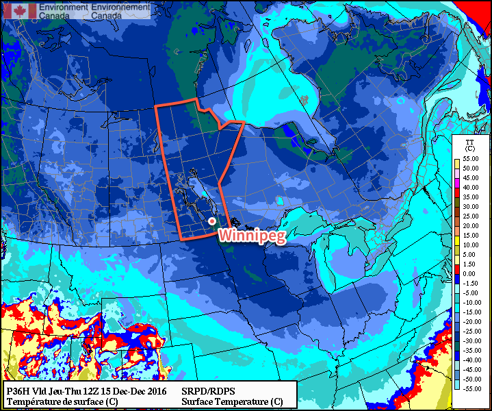
Those looking for a reprieve from the cold will have to wait longer. Temperatures are set to remain cold throughout the week with even colder air set to move into the region for the weekend.

Today will bring a little sun and a little cloud to the region with temperatures climbing to a high near -18°C. There will be a slight chance of some light flurries, particularly in the afternoon and evening, but it won't amount to anything substantial. Skies will be clear tonight with temperatures plummeting to a low near -29°C as another surge of Arctic air pushes southwards behind a cold front that passed through late Tuesday evening. It doesn't look like we'll crack -30°C at this point, but we'll likely be flirting with the value.

Thursday will bring sunny skies and cold temperatures as a ridge of high pressure settles over the region. With a high of just -21 or -22°C, Winnipeg will be nearly 8°C below normal for this time of year. Thursday night won't be as cold, however, as "milder" air from the Yukon spreads southwards and eastwards into the region. The overnight low should be around -24 or -25°C on Friday morning.

The RDPS is suggesting temperatures may fall below -30°C early Thursday morning, but other models suggest slightly warmer temperatures.

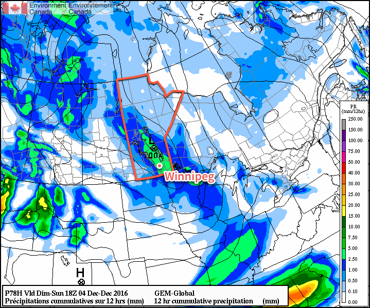
Friday will see a return to highs above the -20°C mark with temperatures climbing to -18°C or so. Skies will be fairly cloudy as that weak disturbance carrying the Yukon "warmth" moves through, and there will be a slight chance of some light flurries through the day. Again, nothing particularly notable with just a dusting of snow possible. Temperatures will drop to around -26°C on Friday night under mixed to cloudy skies.

Long Range

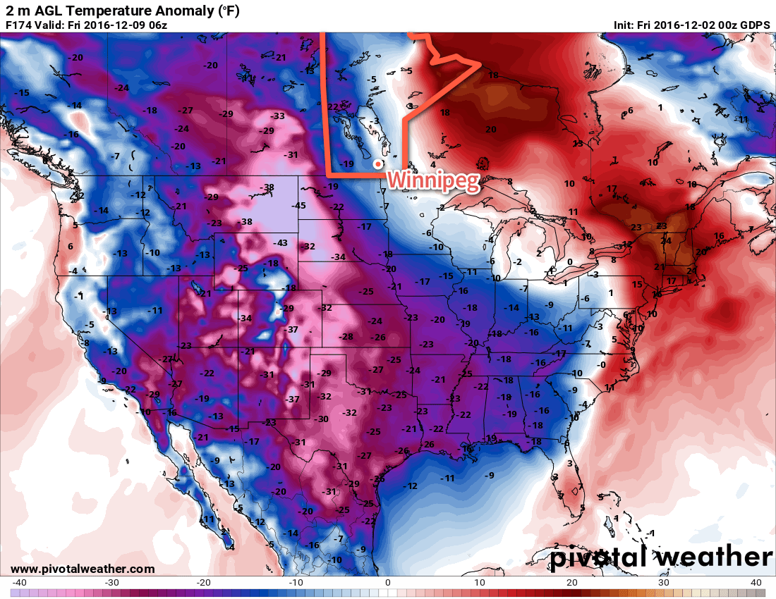
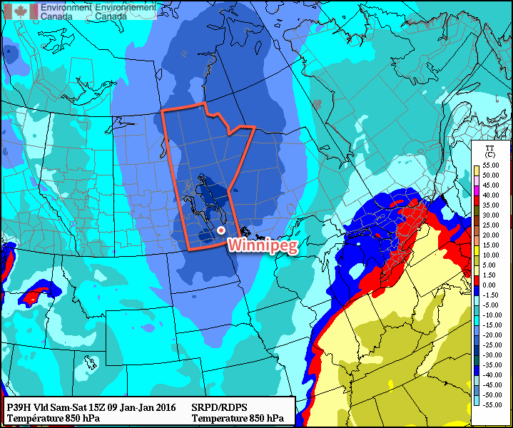
The weekend is looking fairly brutal as another cold front moves through on Friday and ushers another, more powerful shot of Arctic air into Southern Manitoba.

An outbreak of bitterly cold Arctic air is expected this weekend.

This winter blast will push all the way south into Oklahoma, ensuring that the entire eastern half of the Canadian Prairies is entrenched in bitterly cold air. At this point, it seems quite likely temperatures will fall below -30°C on Saturday night alongside a good chance of widespread extreme cold warnings from Environment Canada.

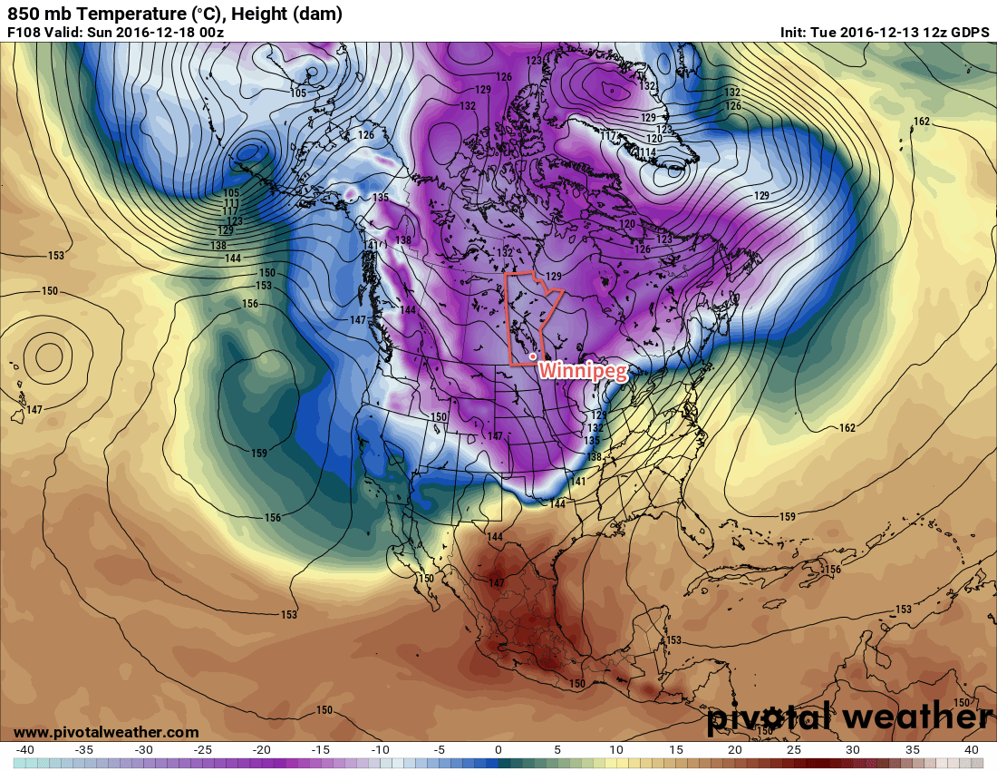
The light at the end of the tunnel, though, is that warmer air is forecast to arrive next week as a powerful surge of Pacific air sweeps eastwards across the Prairies, sending highs back up into the minus single digits. There's a lot of uncertainty at this point, and I think that models are generally warming Winnipeg up too quickly with the cold weather likely hanging on an extra day with very windy conditions out of the south before the mild air actually arrives.

It seems quite likely that more seasonal to slightly above seasonal temperatures will be in place for the week leading up to Christmas.

Winnipeg’s seasonal daytime high is currently -10°C while the seasonal overnight low is -20°C.

Cool With Occasional Snow, Then Temperatures Plunge

The coming days will see a fair amount of cloud and several chances for snow, but temperatures will continue to be slightly above seasonal values. A big change is on tap for next week when a massive blast of Arctic air will plow through much of Canada and the United States, sending temperatures plummeting off a cliff. Time to dig out all the winter clothes.

More of the same. This weekend’s weather will bring little difference from the past several days as low cloud continues to linger through the region. The high temperature today will sit near -2°C with a light winds. Winnipeg & the Red River Valley may see some light isolated snow showers, but no accumulations are expected and for the most part it should just be a mainly cloudy day.

Temperatures will drop to a low near -5°C tonight with a few breaks in the cloud showing up overnight. Winds will pick up out of the south to about 15 km/h by Saturday morning.

Saturday may bring some sunshine through the morning hours, but skies will cloud back up through the afternoon ahead of the next low pressure system moving through. Temperatures should climb to a high near 0°C with continued south winds at 15-20 km/h. Heading into the evening, an area of light snow will spread eastwards into the province as a low pressure system moves into the Interlake from southeastern Saskatchewan. Temperatures will dip to a low near -2°C.

An area of snow will push across Southern Manitoba Saturday night into Sunday morning.

Sunday morning will see the snow gradually tapering off with total amounts close to 2 cm. After that Winnipeg will be left with mostly cloudy skies and the continued chance for some isolated light snow showers. Temperatures will remain steady near -2°C before falling to a low near -6°C on Sunday night under partly cloudy skies.

Long Range

Monday will bring the potential for another snow storm to the region as a low lifts northwards through eastern North Dakota into northern Minnesota. Best guesses at this point are for another 5-10 cm of snow over the Red River Valley and 10-20 cm over southeastern Manitoba. Slight changes in track could result in significant changes to forecast snowfall amounts, though, so we’ll have to keep an eye on it as this system develops through the weekend.

Behind that system, the big story will be the temperature crash over North America:

The GDPS is forecasting a substantial outbreak of Arctic air next week.

Temperatures over a large area are forecast to be 10-20°C below normal as a cold air mass crosses over the pole from Siberia into North America. Here in Manitoba, it appears like we’ll avoid the worst of it with temperatures dipping to seasonal to slightly below seasonal values, but to the west and south winter will be arriving in full force. After a November that saw every single day with above normal temperatures, it will likely be quite a shock to the system!

Winnipeg’s seasonal daytime high is currently -7°C while the seasonal overnight low is -16°C.

Milder Weather Ahead, But Deep Freeze Looms

A few morning flurries will mark the arrival of slightly milder air than has been in place over Southern Manitoba over the past several days, however the reprieve will be brief as another potent blast of Arctic air spills southwards for the weekend.

This morning will start off with a few flurries tapering off as a weak disturbance shunts by to the south of Winnipeg, leaving behind mainly cloudy skies for the day. There will be a slight chance of continue flurry activity through much of the day thanks to favourable snow-making temperatures throughout the depth of the cloud cover, but with the lack of any real focus for the snow, it will be very light if it occurs and pose no likelihood of any accumulation. Temperatures will be slightly milder than the highs near the -20°C mark that have been in place over the last few days; today’s high should climb to around -15°C with light southerly winds while the low tonight drops to around -19°C under mostly cloudy skies.

Thursday will bring a pair low pressure system through the province; the first skirting through the southwestern corner and the southern Red River Valley before exiting into Minnesota while the second drops down from Northern Manitoba, eventually merging into the first low near Lake Superior. This makes the forecast a little bit trickier, but fortunately neither system will bring particularly significant weather with it. The southern low will produce a swath of 2-3cm of fresh snow through southwestern Manitoba into the southwestern Red River Valley, while areas to the north and east see some light flurry activity.

RDPS 12hr. Precipitation Accumulation for Thursday
The RDPS is showing the main swath of snow from Thursday’s system well to our south…perhaps too far south.

Winnipeg appears to be near the edge of that, so throughout the day on Thursday we’ll likely see fairly cloudy skies with a chance of some flurries or perhaps even some light snow if the whole system pushes a little further to the east. Temperatures will climb a little higher than today, with a high temperature near -13°C expected.[1] Skies will remain fairly cloudy on Thursday night with a chance of flurries; the overnight low should be near -22°C.

With the low pressure systems off to our southeast, all that will be left is for the Arctic air to begin building back into the region unimpeded. This next shot of cold looks, at this point, to be colder than the last by a couple degrees. Friday will mark the entrance of that air, with northwest winds near 15-20km/h and a high near -19°C under partly cloudy skies. The overnight low on Friday night will sit near a very chilly -28 or 29°C.

Bitterly Cold Weekend Ahead

This weekend will be particularly cold thanks to a deep Arctic air mass that will slowly move through the region.

850mb Temperature Forecast for January 15-18, 2016
This animation of 850mb temperatures from Friday morning to Sunday morning shows the bitterly cold air moving over the province.

It will begin moving in on Friday, the core of it will be over Winnipeg on Saturday, and then it will begin shuffling off on Sunday. Unfortunately, as these systems move to the southeast, temperatures here at the surface tend to stay quite cold despite the warmer air moving in aloft thanks to an outflow of cold air out of the ridge to our south.

This will mean daytime highs likely around -24 or -23°C this weekend with overnight lows in the -28 to -30°C range. There’s also some indications that there will be 10 to 20 km/h winds through the weekend, which would likely mean Environment Canada would issue extreme cold warnings for wind chill values at night in the -38 to -44 range.

Temperatures will begin to moderate back towards -20°C or the low minus teens early next week.


  1. It’s worth noting that this system will have quite a sharp temperature boundary associated with it, so if everything were to shift east a bit we could see temperatures climbing above -10°C in Winnipeg; conversely, if it were to track further west, we could see daytime highs limited to around -17°C.  ↩

Arctic Chill Settles Over Manitoba

Winnipeg will see some of the coldest weather of the winter as Manitoba falls under the influence of the infamous Polar Vortex. Unlike other brief cold snaps seen this winter, this cold spell looks to be rather persistent, with only one brief warm-up on the horizon before the Arctic air returns.

Today will start with a few remaining flurries pushing out of the region as a cold front sweeps through the province. Winds will be out of the northwest at 20-30km/h for much of the day. Once the flurries move out this morning, the Red River Valley will be left with mainly cloudy skies and falling temperatures. By late this afternoon, the temperature will sit around -18 or -19°C.

Skies will remain fairly cloudy tonight as temperatures dip to -26°C.

Forecast 850mb Temperatures — RDPS 00Z Jan 08, 2016
The core of the coldest air in North America will be anchored over Manitoba on Saturday morning.

Saturday will mark the full arrival of the Arctic air. The high temperature will be limited to only -21°C with light northwesterly to westerly winds. There’s some uncertainty as to how much cloud cover will remain in the area, but it appears that we’ll likely see mixed skies here in Winnipeg. A little bit of clearing will move in on Saturday night as temperatures dip to around -25°C.

Sunday will continue the cold trend with daytime highs near -20°C under partly cloudy skies and light south to southwesterly winds. Sunday night will continue seeing partly cloudy skies with a low near -25°C.

Weather Roller Coaster Next Week

Unfortunately, next week doesn’t look to offer too much of a reprieve from the cold. This outbreak of colder weather has been driven by a weakening of the Arctic Oscillation (AO) which has allowed colder air to spill southwards. Despite the strong El Niño, the reality often is that cold air is king, and it’s managed to shunt out the warm air. The coming week will be a battleground between the blocking pattern of the Polar Vortex and the attempt for a more typical El Niño pattern featuring warmer weather and a more progressive pattern.

The first half of next week looks fairly cool with daytime highs in the -15 to -20°C range and a slight chance of snow on Monday into Monday night. There is hope for a more substantial warm-up mid-week, however.

A surge of significantly warmer air is expected to spread eastwards on Tuesday with some light snow associated with it. General consensus is that an Alberta Clipper will develop over Northern Alberta and then race southeastwards along the baroclinic zone, flattening it out and sweeping cold air southwards in its wake.

Exactly how warm it manages to get in Winnipeg will depend substantially on the timing and exact location of the setup. Some forecasts show the warm air fully pushing into the region and resulting in daytime highs mid-week near -8°C, while others have a more southerly track and occlude the warm air out to the south quickly and keep temperatures fairly cold.

After the passage of the clipper and any associated snow, the Polar Vortex is expected to retrogress and usher another shot of very cold air into Manitoba.