Snowy Weekend Ushers Winter Blast Into Southern Manitoba

Winnipeg will see a couple more mild days before a passing low brings snow, gusty northerly winds, and much colder temperatures to the region.

RDPS 2m Temperature Forecast valid 21Z Friday December 3, 2021
Southern Manitoba will more seasonably mild conditions on Friday and Saturday.

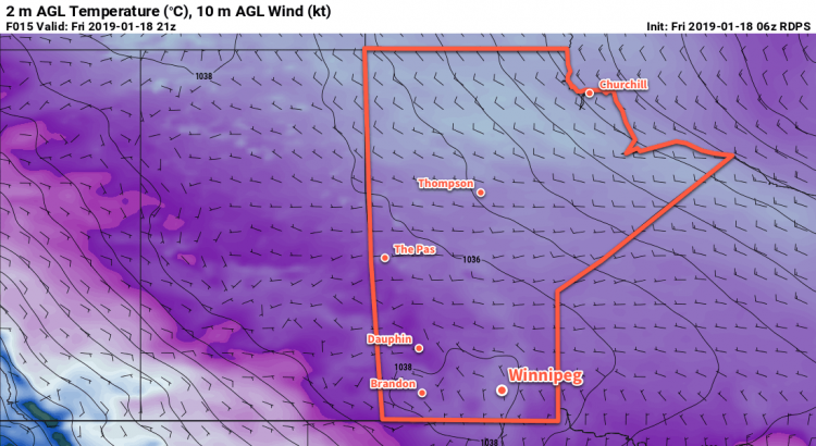
A strong, zonal flow aloft will continue to spread mild Pacific air across the Prairies over the next couple days. This will keep Winnipeg’s high temperatures in the -5 to 0 °C range through Saturday under variable cloudiness.

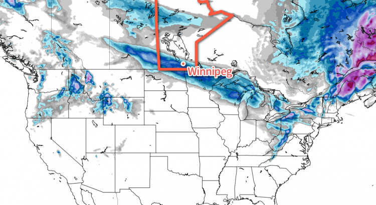
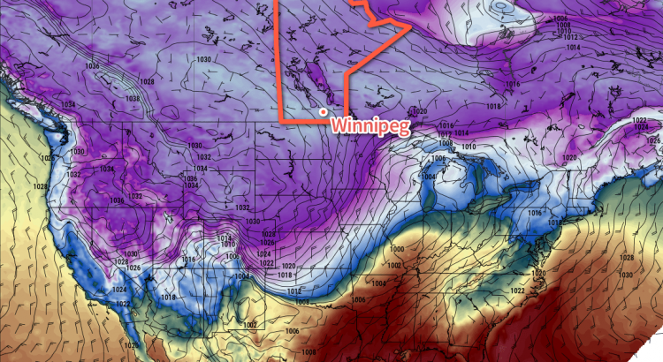
The next notable weather system will be a low pressure system moving through the northern United States this weekend. This system will bring two distinct weather events to southern Manitoba, beginning on Saturday night.

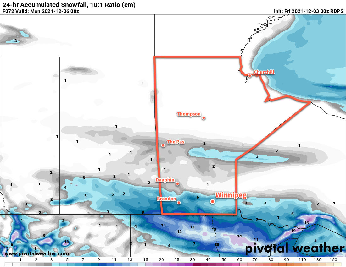
The first phase of this system will be an area of light snow that spreads across southern Manitoba on Saturday night. Primarily from the Trans-Canada Highway (TCH) corridor and south, light snow will move from southwestern Manitoba on Saturday evening to Lake of the Woods by midday Sunday. Accumulations with this first wave of snow will increase from 0–2 cm along the TCH corridor to 5–10 cm along the international border.

RDPS 24hr Snow Accumulation Forecast valid 00Z Monday December 6, 2021
Another swath of snow will fall across southern Manitoba on Saturday night into Sunday, but there is some uncertainty in how far north it will extend.

The second phase of this system will be an arctic cold front that sweeps through the region Sunday afternoon into the evening. This front will support some flurries as it moves through as breezy northerly winds shift to the northwest. Temperatures will hover around -6 or -7 on Sunday, but for those planning on attending the football game, note that wind chills will be closer to -15 and it’ll be a brisk wind that develops later in the afternoon.

RDPS 2m Temperature Forecast valid 12Z Monday December 6, 2021
Bitterly cold Arctic air will surge southwards through the Prairies by Monday morning with widespread temperatures of -20 to -30 °C.

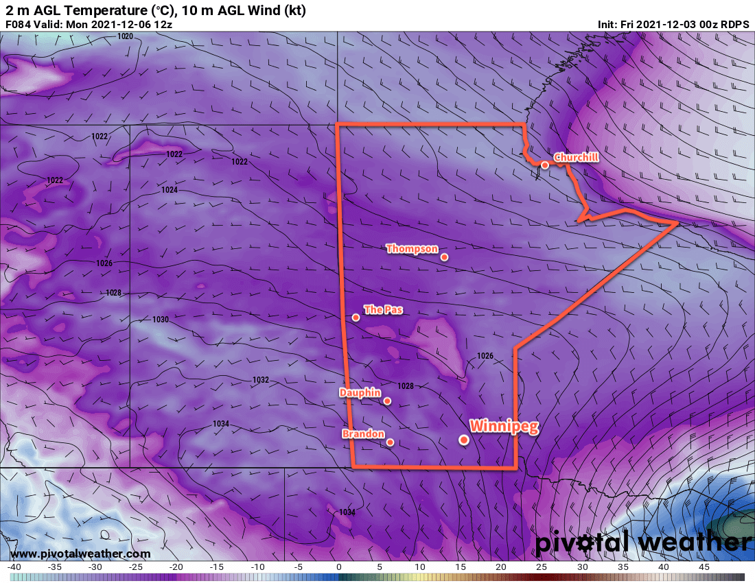
Skies will clear out behind the front on Sunday night as winds die off. Temperatures across the region will plummet to a low of -20 to -25 °C.
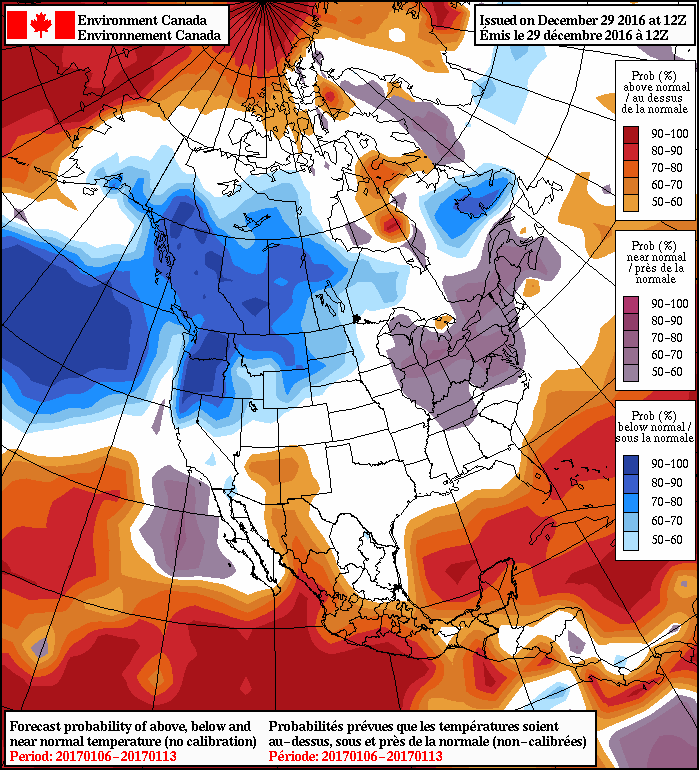
Long Range Outlook

Below seasonal temperatures will linger over the region to start next week with daytime highs of -15 to -20 °C on Monday and -15 to -10 °C on Tuesday. Seasonal conditions will move in on Wednesday, followed by a warmer Thursday with a chance of snow. Cooler temperatures are forecast to return for next weekend.

Today’s seasonal daytime high in Winnipeg is -7 °C while the seasonal overnight low is -16 °C.

Winnipeg Locked In Winter’s Icy Grip

Winnipeg will endure the coldest weather so far this winter over the next couple days.

A potent Arctic ridge entrenched over the region will keep Winnipeg locked in bitterly cold Arctic air today and tomorrow. Temperatures will remain well below normal with daytime highs in the low minus 20s. Overnight lows dipping into the minus thirties, likely resulting in the continuation of extreme cold warnings from ECCC.

Winnipeg will see increasing cloud cover on Saturday evening as a more seasonal air mass pushes eastwards towards the province. Temperatures will dip into the -30s early in the evening, then slowly rise overnight. Sunday will bring mixed skies to the region with a chance of flurries. Winnipeg will finally escape the deep freeze as temperatures rise to a high near -16°C, however winds will be breezy out of the south near 30 km/h. More cloud will build into the region on Sunday night as temperatures continue to climb to around -13°C by Monday morning. It’s likely that Winnipeg will see periods of light snow on Sunday night, but it shouldn’t accumulate to much more than a dusting.

Long Range Outlook

Winnipeg will see near-seasonal temperatures to start next week with cloudy conditions and a continued chance of flurries. The region will see variable cloudiness heading into mid-week, then a cold front is forecast bring slightly cooler than seasonal temperatures back to the region. At this point, next week’s cool-down doesn’t look as extreme as the current deep freeze gripping the city.

Winnipeg’s seasonal daytime high is currently -13°C while the seasonal overnight low is -23°C.

Alberta Clipper Plunges Manitoba into the Deep Freeze

An Alberta Clipper crossing the province today will bring another accumulating snowfall to the region and then usher in a major pattern change that will plunge Central Canada into a deep freeze.

Snow is on tap today for all of the Red River Valley courtesy an Alberta Clipper moving through the region. Snow will spread eastwards through the morning, moving into the Red River Valley between 9AM and 12PM. Snow will persist until the early evening before tapering off.

A large area of 5-10cm of snow is expected today, with a narrow swath likely receiving just over 10cm.

By the time all is said and done most areas along the swath of snowfall will see between 5-10 cm of new snow, however a swath running from Brandon east-southeast through the southern Red River Valley will likely see slightly over 10 cm.

This snowfall comes hot on the heels of a major winter storm that dumped 18-33 cm of snow in Winnipeg on Monday.

Aside from the snow, today will be a little warmer than normal with a high near -10°C. Particularly in the morning, a southeasterly wind of 15-25 km/h will make it feel rather chilly. Winds will ease through the afternoon as they back to north-northwesterly by late this evening. Skies will remain mixed to cloudy overnight with lows dropping to around the -18°C mark.

Saturday will bring mixed to cloudy skies in the morning, with thicker cloud cover and a chance of flurries moving into the region in the afternoon as another low pressure system slumps down from the northwest. Temperatures will continue to be seasonably mild with highs near the -8°C mark. With the new system cloud moving in for the afternoon, a chance of flurries will return to the region. No significant accumulations are expected with this system, but there may end up being enough to get a slight layer on your windshield. The cloud and chance of flurries will continue overnight as temperatures drop to a mild -12°C.

Sunday will start off with cloud and a chance of flurries, but that will clear out through midday as a very broad cold front pushes southwards. Highs will recover a couple degrees from the overnight low to around -10°C, but temperatures will begin dropping sharply when the cloud clears out in the afternoon and colder air begins working in from the north. Lows are expected to drop to around -22°C on Sunday night under clear to partly cloudy skies.

Prairies Fall Into An Arctic Grip

The big story for next week will be the dramatic pattern shift which plunges bitterly cold air southwards across the Prairies and produces daytime highs 5-10°C below normal for this time of year.

Climate Prediction Center’s 6-10 Day Temperature Anomaly Outlook valid January 4-9, 2016

Daytime highs are expected to fall through the first half of the week from the mid-minus teens towards the -22 to -24°C range for the second half of the week. Overnight lows are a bit of a trickier challenge as there’s not a lot of certainty as to how much clearing we’ll see, and overnight cloud cover can dramatically impact how cold it gets. There is very high confidence in this cold snap as shown in the above CPC1 graphic, which has a ≥90% chance for below-normal temperatures across much of the western United States (and by extension, the southern Canadian Prairies). This is the largest extent of 90% probability of below-normal temperatures in the 15-year history of this outlook.

NAEFS 8-14 Day Temperature Anomaly Forecast — Valid January 6-13, 2017

The cold weather is expected to persist into the following week as well, but may begin abating in the 10-14 day range.


  1. Climate Prediction Center 

Bitterly Cold Weekend; Warmer Weather Next Week

The coldest temperatures of the winter are on their way to southern Manitoba as a reinforcing blast of Arctic air descends from the north. The cold snap will persist into the start of next week, but milder air is expected to arrive by Tuesday or Wednesday.

The next few days will be very quiet weather-wise other than the fact that bone-chilling cold is moving into the province. Winds for the next few days will be between 10-20 km/h out of the northwest slowly backing to southerlies by Sunday. Skies will be mainly sunny through the weekend.

Bitterly cold air will descend into Southern Manitoba this weekend.

The big story is the cold, shown above with the 850mb1 temperatures. The potency of this Arctic outbreak is highlighted by temperatures at this height reaching -30°C, a sign of a truly cold air mass.

This will result in temperatures dropping from a high near -21°C today to a low just below the -30°C mark. Temperatures will struggle to recover to the mid-minus 20's on Saturday before dipping to a low near -32°C on Saturday night. Sunday will see warmer air aloft working into the region, allowing temperatures to moderate towards around -22°C by late in the afternoon. Some cloud cover will begin working in through the afternoon and cloudy skies on Sunday night will bring the chance for some light snow with temperatures hovering around -23°C.

Wind Chill

Wind chill values will be a concern this weekend, likely reaching Environment Canada's warning criteria of -40. Winds slightly over 10 km/h both Friday and Saturday night will combine with low temperatures dipping below -30°C to produce wind chill values in the -39 to -44 range. Wind chills of this severity can result in frost bite on exposed skin in 5-10 minutes, so be sure to take precautions and layer well if you need to be outside at night.

As an aside, it's worth reminding people that wind chill is not a temperature. Wind chill describes what the temperature would have to be with no wind to lose body heat at the same rate as the actual temperature with wind. So wind chill of -40 produced by a night with temperatures of -29°C and a 15 km/h wind describes that the rate of heat loss in the actual conditions is the same as if it was -40°C outside with no wind.

Wind chill has numerous problems, but does serve as an imperfect method of communicating a very real thing.

But just keep in mind that it is not a temperature, but an expression of a rate of heat loss.

If you want to know more about wind chill, visit our article "The Problem With Wind Chill"

Long Range

Early next week will bring milder air back to the region. By mid-week, highs should be back into the -10°C to -5°C range. Before that warm air arrives, though, it's quite possible we'll see quite unpleasant conditions with moderate southerly winds making it feel much colder than the temperature would imply. That said, there's high confidence that the warm air will get here by mid-week, so if you can make it through this cold snap, more pleasant conditions await on the other side.

Winnipeg’s seasonal daytime high is currently -10°C while the seasonal overnight low is -20°C.

  1. This height is approximately 1.5km above sea level.