Cold Snap Eases; Milder Weather Ahead

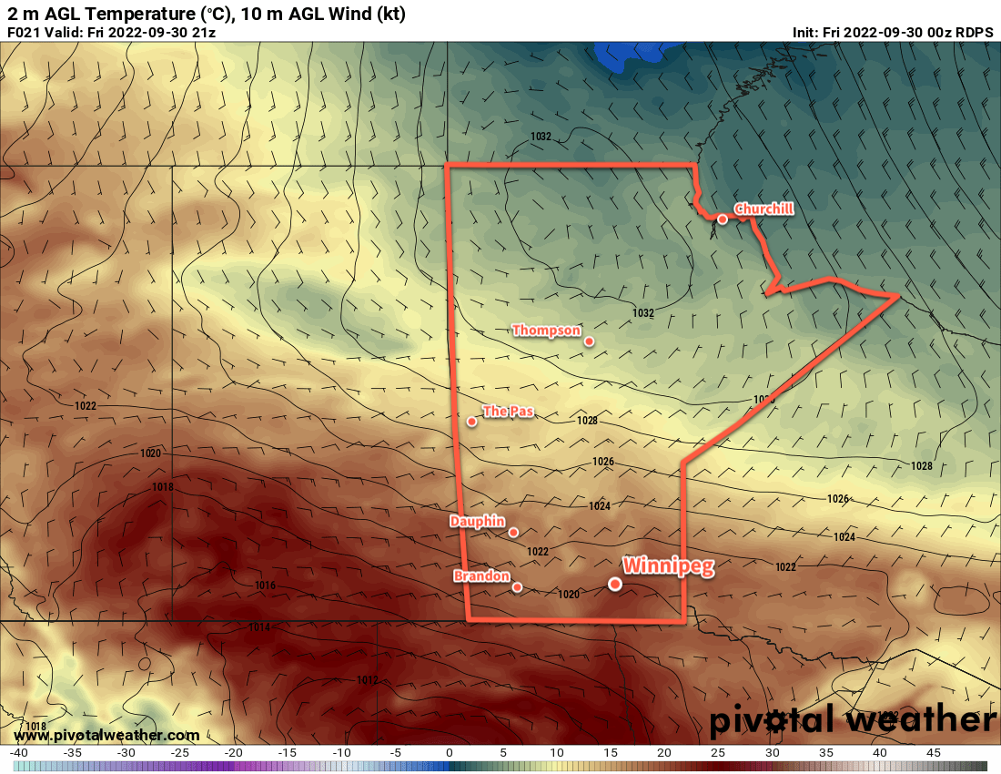
After the first hard freeze of the season, Winnipeg will see temperatures moderate back to seasonal values this weekend.

RDPS 2m Temperature Forecast valid 21Z Friday October 7, 2022
Although it will be a cool day with a high near 10 °C in the Winnipeg area, warmer temperatures are already beginning to build back into the region from the west.

Winnipeg will see daytime highs gradually recover over the next few days as an Arctic high exits the region. Milder air will gradually push into the region, sending daytime highs from close to 10 °C today into the low to mid-teens this weekend. Overnight lows will also recover, climbing back above here freezing mark for the weekend.

The region will see southwesterly winds pick up today into the 20 to 30 km/h range today, but lighter winds will return for the weekend. The region will see mainly sunny skies today give way to mixed skies on Saturday. More sun will return on Sunday with partly cloudy conditions.

Long Range Outlook

A push of warmer weather will arrive to start next week with daytime highs climbing into the 15 to 20 °C range. Cooler weather will return with a system moving through Tuesday night into Wednesday; this disturbance will also bring cloud and a chance of showers to for the region mid-week. After it passes, the region should see variable cloudiness and near-seasonal temperatures.

Today’s seasonal daytime high in Winnipeg is 13 °C while the seasonal overnight low is +2 °C.

Pleasant Fall Weather Ahead for Southern Manitoba

A broad upper ridge will keep the jet stream well to the north over the next 5 to 7 days, keeping the frost away as seasonably mild temperatures stay across the region.

RDPS 2m Temperature Forecast valid 21Z Friday September 30, 2022
Mild temperatures in the low 20s will develop across much of the southern Prairies on Friday.

The weather will be quiet across southern Manitoba over the next several days as an upper ridge continues to sit over the region. Most areas will see a bit of cloud this weekend as an upper low passes through the Northern Plains of the United States, but almost all the rain associated with the system will stay south of the international border.

There will be slight chance of some light showers Saturday night into Sunday, but any amounts will be light and scattered. The upper low will begin to shift out of the region at the beginning of next week, taking the cloud with it, leaving behind mild temperatures to start the week.

Through this mild period, Winnipeg will see daytime highs in the upper teens or low twenties with overnight lows in the upper single digits.

Long Range Outlook

A cold front will push through the region mid-week, ushering cooler conditions. Daytime highs will drop towards the 10 °C mark with frost likely at least a couple times in the second half of the week. No hard freeze is in the forecast, but lows will likely dip just below freezing a couple times.

Before then, though, the weather will be quite pleasant. With the long weekend ahead, we hope you’re able to get out and enjoy some of that fall warmth before it disappears!

Today’s seasonal daytime high in Winnipeg is 15 °C while the seasonal overnight low is 3 °C.

Fall Chill Eases As Week Continues

The cool conditions starting the week off will be replaced by warmer weather as an upper ridge moves across the Prairies.

RDPS 2m Temperature Forecast valid 21Z Thursday September 29, 2022
Much warmer weather will push eastwards into the Prairies this week as an upper ridge builds over the region.

Winnipeg will start the day off today with a touch of frost courtesy a strong high pressure system sitting over the province. This system will keep skies sunny and temperatures seasonal with highs in the mid-teens this afternoon. Temperatures will dip back down into the low single digits tonight with a light southerly wind developing. Sub-freezing temperatures are unlikely in Winnipeg tonight, but outlying areas could see temperatures touch the freezing mark.

Heading into the rest of the week, the high responsible for the cool weather will shift off into Ontario and an upper ridge will build in behind it. This will bring warmer weather back to southern Manitoba and shift the region into an extended period of seasonably warm conditions.

Mainly sunny conditions will persist through the rest of the week with daytime highs climb into the low 20s and overnight lows in the upper single digits. Wednesday will be more of a transition day, though, with a strong southerly wind up to 50 gusting 70 km/h and a high in the upper teens.

There’s just the slightest chance of a light shower on Wednesday evening, otherwise it will be dry through the rest of the week.

Long Range Outlook

Some cloud is possible later Friday into Saturday, but temperatures should continue to be seasonably mild. Mainly sunny conditions are forecast to return Sunday and continue into much of next week. The forecast shows no notable precipitation in the next 10 days.

Today’s seasonal daytime high in Winnipeg is 15 °C while the seasonal overnight low is 4 °C.

Seasonal Weather Ahead for Winnipeg

Winnipeg will see near seasonal temperatures for the next couple days behind the cold front that moved through yesterday. On Sunday, warmer weather will begin to push back into the region.

RDPS 2m Temperature Forecast valid 12Z Sunday September 11, 2022
Temperatures could drop a cool as the low single digits across southern Manitoba on Saturday night.

An upper trough will sit over Manitoba for the next couple days and bring seasonal temperatures to much of southern Manitoba. Winnipeg will see daytime highs today and tomorrow near the 20 °C mark, which is seasonal normal high for this time of year. Overnight lows will be cool, driven down by an area of high pressure moving into the area.  Overnight lows will dip into the upper single digits tonight, and could reach as low as 2 to 4 °C on the edges of the city on Saturday night. Areas near the centre of the city will likely stay a couple degrees warmer than that.

On Sunday, the upper pattern will shift and a more zonal flow along the apex of an upper ridge in the United States will develop. This will bring warmer air into the region and send daytime highs back into the mid-20s. Lows should climb back to around the 10 °C mark on Sunday night. Skies will stay mainly sunny through the day.

Long Range Outlook

Temperatures will continue to warm for Monday with highs in the upper 20s possible. A cold front will push through later Monday, ushering near-seasonal temperatures back into the region for the rest of the week. Skies will likely trend towards the mixed to cloudy side of things with the chance of showers developing mid-week.

Today’s seasonal daytime high in Winnipeg is 20 °C while the seasonal overnight low is 7 °C.