Bitter Cold Continues Across Southern Manitoba

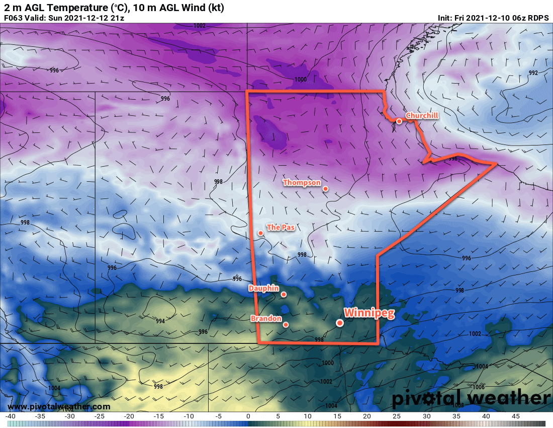
Winnipeg will stay locked in the grip of a deep freeze as a slow-moving Arctic air mass sits entrenched over the region.

RDPS 2m Temperature Forecast valid 12Z Wednesday February 23, 2022
Very cold temperatures will stay entrenched over Manitoba this week.

Temperatures in Winnipeg will sink over 15 °C below seasonal values this week with highs struggling to reach -20 °C. A bitterly cold Arctic air mass has settled over the region behind the train of storms that brought several waves of snow to the region last week. Unfortunately, this air mass is in no hurry and this week will bring little relief will from the cold.

Skies will continue to be mixed today as the region is grazed by a system moving through the United States. Skies will clear tonight, leaving sunny skies for the rest of the week. Daytime highs will sit below -20 °C through much of the week, only breaking into the mid-minus teens on Friday. Overnight lows will be, editorially speaking, terrible; lows will dip below -30 the next couple nights and climb into the low -20s on Thursday night.

Wind chill will be a notable danger today. Northerly winds of 20–30 km/h continue through the day and produce morning wind chills of -45 to -50 easing to the mid-minus 30s in the afternoon. Wind chills will dip back into the -40 to -50 range tonight.

Long Range Outlook

The Arctic grip will begin to break at the end of the week with highs near the -15 to -10 °C range returning to the region. A system moving through will bring a chance for some snow on Saturday, followed by cooler temperatures on Sunday. All indications are that near-seasonal temperatures will return through the first half of next week.

Today’s seasonal daytime high in Winnipeg is -6 °C while the seasonal overnight low is -17 °C.

Sunshine and Mild Early-Winter Warmth Ahead

Benign and pleasant early winter weather will settle in for Winnipeg this weekend.

The broad shift in the upper-level weather patterns we talked about earlier this week are underway. Gone is the Arctic vortex locked over Hudson Bay, allowing an upper ridge to build eastwards off the Pacific. This will be the dominant weather feature for the next couple days before it flattens out for the end of the weekend. Instead of being replaced by an upper trough and the associated cold air that comes with it, though, a generally zonal to west-southwest flow will develop aloft, continuing to spread mild temperatures across the southern Prairies.

As a result, Winnipeg’s forecast is quite pleasant for the days ahead. Right through the weekend into next week, the area will see daytime highs in the -5 to 0 °C range. A couple of these days may even see temperatures climb above freezing. Overnight lows will be similarly mild, generally falling in the -5 to -10 °C range.

RDPS 2m Temperature Forecast valid 21Z Sunday December 12, 2021
Very mild December temperatures will spread across the southern Prairies this weekend. Most areas will see highs above freezing on Sunday.

Winds will be light for the region today, but for the weekend southerly winds around 20–30 km/h will develop. The windiest conditions should end up over the western Red River Valley where the escarpment can interact with the westerly component to the winds and produce slightly breezier conditions.

Along with these pleasant conditions will be plenty of sunshine; the Winnipeg area will see mainly sunny skies through the weekend. Some cloud cover will begin moving in next Monday and Tuesday.

Long Range Outlook

The next disturbance to impact the region will move through in the middle of next week. Forecasts show it could bring around 5 cm of snow to the region followed by breezy northwest winds and return to more seasonal temperatures. The overall weather pattern after that looks somewhat unsettled with a chance for more snow on Friday/Saturday and potentially again to start off the next week.

Today’s seasonal daytime high in Winnipeg is -9 °C while the seasonal overnight low is -19 °C.

Warming Up in Winnipeg

The weather is going to warm up in Winnipeg this week as an upper ridge builds across the Prairies.

Despite the cold start to the day, today will be a pleasant change from the weather of the past few days in Winnipeg. With the worst of the Arctic ridge to the east, the city will see temperatures climb to a high near 7 °C under sunny skies. Winds won’t be too much of an issue, either, staying light out of the south. Weak ridging will stay over the region tonight which, combined with the light southerly wind, will allow temperatures to fall back to a low near -6 °C.

On Thursday, some warmer air will begin pushing towards Manitoba as an upper ridge builds eastwards. This will bring a few clouds back along with southerly winds of 20–30 km/h. Temperatures will climb to a high near 8 °C in the city. More cloud will push in overnight as a low pressure system begins moving eastwards out of Alberta. With that cloud will come more warm air and southerly winds up to around 30 km/h. This combination of cloud and wind will keep the overnight lows seasonally mild at around +2 °C.

RDPS 2m Temperature Forecast valid 21Z Friday November 5, 2021
Mild Pacific air will sweep across the Prairies over the remainder of the week.

Friday will bring mostly cloudy skies to the region as a low pressure system crosses the province. The southerly winds will gradually weaken through the day as a trough moves into the Red River Valley. Temperatures will be held back a bit by the cloud cover, but the area should still see highs near 9 or 10 °C. There may be a slight chance of rain showers on Friday evening, but much of the precipitation associated with this system should be weakening as the trough advances eastwards. Temperatures will stay mild on Friday night as the trough passes and winds shift westerly. Winnipeg will see a low near +3 °C.

Long Range Outlook

The seasonally warm weather will stick around for the weekend with highs climbing into the low teens. Overnight lows should stay above freezing through the weekend. A change in the weather looks to arrive next Wednesday when a system moving through the Prairies brings several days of unsettled conditions as it sweeps the Arctic front back south across the region. Near-seasonal temperatures should return in the second half of next week.

Today’s seasonal daytime high in Winnipeg is 3 °C while the seasonal overnight low is -6 °C.

Cool Start To The Work Week

November is off to a seasonably cool start as highs in the low single digits send cloud cover streaming off the Manitoba Lakes.

A brisk northwesterly wind will keep temperatures cool and skies cloudier in Winnipeg. The city will see temperatures climb only to around 3 °C today with mixed skies as low cloud streams southwards off the Manitoba Lakes. The lakes are also producing some rain showers/snow flurries, but the winds should keep that activity out of the city. Breezy northwest winds of 30 gusting 50 km/h will pick up late morning and make for a rather chilly afternoon.

The winds will ease this evening as they shift a bit more westerly. This change in direction may end up bringing a few snow flurries into the city from Lake Manitoba overnight. Temperatures will dip to a low near -3 °C with cloudier skies.

RDPS 2m Temperature Forecast valid 12Z Wednesday November 3, 2021
An Arctic high will bring cold temperatures to the southern Prairies on Wednesday morning.

On Tuesday, the wind will continue to shift westerly and ease as an Arctic ridge slumps into the region. This will bring partly cloudy skies to the city with a high around 2 °C. Skies will clear out on Tuesday night, allowing temperatures to plummet to one of the coldest nights of the season. Lows will dip to around -9 °C.

Winnipeg will see sunny skies on Wednesday with temperatures recovering to around +4 °C. It will be a nice day with light winds. Temperatures will dip back down towards -6 °C or so on Wednesday night.

Long Range Outlook

The second half of the week will see a collapse of the upper low sitting over NW Ontario while an upper ridge builds across the Prairies. This will bring a new push of mild Pacific air into the region. Daytime highs will climb back towards the 10 °C mark by the end of the week. Conditions should stay dry until cooler air begins pushing back into the region sometime in the middle of next week.

Today’s seasonal daytime high in Winnipeg is 3 °C while the seasonal overnight low is -6 °C.