Seasonal Temperatures Return to Winnipeg

After one more cool day, breezy southerly winds develop and usher seasonal temperatures back into the region.

A ridge of high pressure moving through southern Manitoba today will keep winds light and temperatures cool. In Winnipeg, the high will sit near 5°C. With so much moisture stuck in the region, skies should remain mostly cloudy through the day. A light southeasterly wind will develop tonight with temperatures dipping to a low near 0°C.

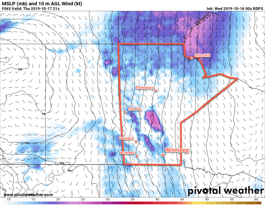
A warm front will move across Manitoba on Thursday, bringing breezy southerly winds. Warm air will push eastwards into the region as the wind increases into the 30 to 40 km/h range. Temperatures will climb to a high near 11°C in Winnipeg, continuing to rapidly melt the remaining snowpack. Winnipeg will see a bit of sun through the day as the clouds giving way to mixed skies. On Thursday night, the cloud cover will thicken back up with breezy winds continuing. This combination of cloud and wind will keep temperatures warmer with a low near 6°C in Winnipeg.

Breezy southerly winds will develop over the Red River Valley on Thursday.

On Friday, a broad trough of low pressure will move across the region. With cloudy skies, temperatures will continue at near seasonal values. Winnipeg should see a high near 11°C again with the southerly winds gradually easing. No significant precipitation is expected, but some scattered light rain is possible. Skies will become mixed again on Saturday night as a westerly wind builds into the region behind a weak cold front. Temperatures will dip down to a low near 5°C.

Long Range Outlook

Seasonal conditions will continue into the weekend with highs in the low teens and overnight lows in the low to mid-single digits. The region should see some sun return for Saturday, but another disturbance moving into the region on Sunday will bring more cloud with a chance of light rain, particularly overnight into Monday.

Today’s seasonal daytime high in Winnipeg is 10°C while the seasonal overnight low is 0°C.

Cleanup Continues With Cool and Cloudy Conditions

Southern Manitoba will continue to see plenty of cloud cover as the region continues to clean up after the historic winter storm last week.

Another low pressure system crossing the Prairies will keep Winnipeg locked under cloudy skies for the next few days. Between the lack of sun and the new snow pack covering the region, temperatures will stay well below seasonal averages. Over the next few days daytime highs will hover near 4°C while low dip to around freezing.

Winds won’t be much of an issue the next while, either. Light southerlies will persist today, switching to northerly on Tuesday as the low passes. Northwest winds of 20 to 30 km/h will develop for Tuesday, but a ridge of high pressure will bring light winds for Tuesday night into Wednesday.

Cooler daytime highs will occur over the fresh snowpack in southern Manitoba and North Dakota.

The only notable weather will be as the low moves through tonight into Tuesday. A wintery mix of light precipitation will move through the Red River Valley overnight, leaving behind a chance of scattered rain showers or flurries for Tuesday. Accumulations will generally be light with 1 to 3 mm for most areas, but a narrow band of 5 to 10 mm may develop along the low track. The heaviest precipitation will remain south of Winnipeg, but whether it occurs in southern Manitoba versus North Dakota is still questionable.

Long Range Outlook

The sun will attempt to reappear in the latter half of the week as warmer air pushes eastwards across the Prairies. Exactly how warm temperatures are able to climb will depend on how much snow remains on the ground. More snow will mean temperatures stay locked into the low single digits. For any areas that are able to eliminate much of the snow pack, highs could climb into the low teens.

No precipitation is expected through the latter half of the week.

Today’s seasonal daytime high in Winnipeg is 11°C while the seasonal overnight low is 0°C.

Gradually Improving Weather in Winnipeg

The weather will slowly improve in Winnipeg through the rest of the work week.

Winnipeg will see a gradual return towards seasonal conditions despite the prevalence of a large Arctic ridge. Today and Thursday will both bring mostly cloudy skies as the high moves through. Temperatures will be seasonably cool with highs in the upper single digits. Earlier in the week it looked like more rain would be possible for Winnipeg, but latest forecasts have shunted the precipitation southwards. Most of the rain will fall south of the border, but a bit may cross the southern Red River Valley tonight. Winds will stay light the next couple days. 

An Arctic ridge will keep the next batch of rain further south with just a chance that it pushes north of the border.

On Friday, sunshine should return to the region with mixed skies as brisk southerly winds develop. As the wind increases to 30 gusting 50 km/h, temperatures will finally climb into the low teens. The cloud cover will thicken up late in the day with a chance of rain developing again on Friday night.

Long Range Outlook

A trough moving across the region will continue to bring a chance of rain through Saturday, then conditions are forecast to settle for much of next week. After the sun returns for the end of the weekend, it looks like it will stick around for much of next week. Temperatures will return to near-seasonal values with highs in the low to mid-teens.

Today’s seasonal daytime high in Winnipeg is 14°C while the seasonal overnight low is 3°C.

Seasonal Temperatures and Quiet Weekend Weather

Winnipeg will enjoy benign weather this weekend before the weather turns unsettled next week.

A ridge of high pressure moving into the province will bring Winnipeg sunny skies and breezy conditions today. Temperatures will climb to a high near 21°C today with northwesterly winds picking up into the 30 gusting 50 km/h range. Winds will abate quickly this evening as the ridge moves in and sends temperatures to a low near 8°C.

On Saturday, a low pressure system crossing through the Northern Plains of the United States will graze the region. The rain will stay south of the border, but plenty of cloud will spread into the region. Winnipeg will find itself near the cloud edge, likely leading to mixed skies through the day. Areas south of Winnipeg will see cloudier conditions while areas north see a bit more sun. Temperatures will be cooler with a high near 17°C, but lighter winds will make for a relatively nice day. The cloud cover will clear out on Saturday night with temperatures heading to a low near 5°C.

Mainly sunny skies will return on Sunday with temperatures climbing to a high near 19°C. A weak ridge of high pressure will extend across southern Manitoba, keeping winds light. More cloud will begin pushing back into the region on Sunday night ahead of the next disturbance. Temperatures will head to a low near 8°C.

Long Range Outlook

A major change in the weather is forecast next week as several major low pressure systems are forecast to move through the region.

The first is a Montana Low that is forecast to spread rain with the risk of thunderstorms into southern Manitoba on Monday night. This system will be very sensitive to the location of a high pressure system over the northern Prairies; it will be pumping dry air southwards as well as support a strong deformation zone along the northern flank of the low. If the high slumps further south, the rain could end up remaining south of the border. Current forecasts have the rain tapering off on Tuesday with the potential for a widespread 10 to 30 mm.

The second system is a Wyoming low forecast to push into Manitoba on Thursday night. This low will support a large area of thunderstorm activity across the Northern Plains and spread a broad area of rain with the risk of thunderstorms into parts of Saskatchewan and much of Manitoba. It’s far out, so the forecast on this system is definitely subject to change, but could produce a widespread 20 to 40 mm over much of southern Manitoba.

We’ll be keeping an eye on these systems as they develop heading though next week.

Today’s seasonal daytime high in Winnipeg is 20°C while the seasonal overnight low is 8°C.