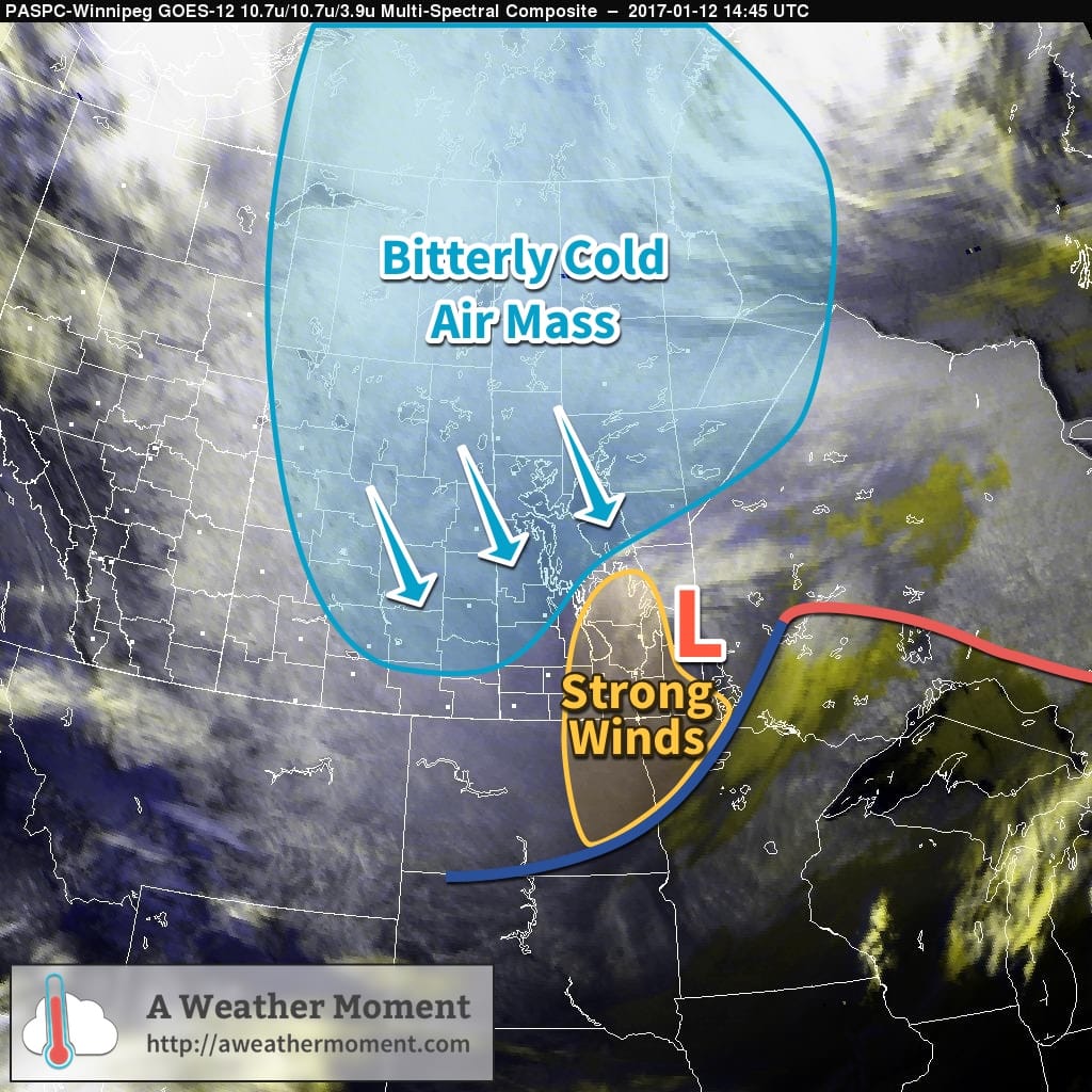
A potent Mackenzie Low dropped southeastwards through Saskatchewan yesterday riding along with a frontal wave that increased temperatures here in Winnipeg overnight. Behind this system is—for one of the first times this year—a potent Arctic air mass ready to surge southwards.
Today’s major weather features.
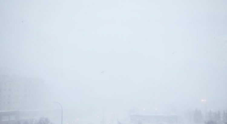
As a result, very strong winds developed in the rear of the cold front, supported through a deep layer as evident by a 120 km/h+ jet just off the surface that was visible on Doppler RADAR earlier this morning. Surface winds reached as high as 80-90 km/h behind the cold front which, combined with plenty of loose snow from our extra fluffy snowfall event the other day and some light falling snow, produced white-out conditions across many parts of Southern Manitoba.
The strong winds will move off to the east-southeast with the low pressure system through the morning and visibilities will improve. However, that bitterly cold Arctic air mass will move in through the day, sending temperatures south to around -26 or -27°C by the end of the afternoon here in Winnipeg. Temperatures will continue to drop to a low near -33°C on Friday morning with wind chill values of -42 to -45.
The cold weather will be short-lived as a mild Pacific air mass will begin building into the region this weekend.
The blizzard that has brought much of southern Manitoba to a halt will end today, making way for much calmer weather.
This Week
The crippling blizzard that began last night will gradually end today. Winds this morning will be northwesterly at 40 km/h gusting to 60 km/h, decreasing as the day progresses. Snowfall will end from west to east across southern Manitoba this morning, which will also help to improve visibility. Skies will remain cloudy through the afternoon, with just a lingering chance of flurries. Roads beyond the major routes will likely be impassable today as snow drifts will be significant in many exposed areas. Luckily, calmer weather is expected for the rest of the week, giving folks a chance to recover from yet another significant December blizzard.
Tuesday will be a fairly typical winter day with high temperatures in the mid minus teens and a mixture of sun and cloud. Winds will be fairly light, helping to keep wind chill values at bay. Thankfully, this should provide decent weather for those still shoveling out from the storm.
A rapid warm-up will occur on Wednesday as a fast-moving system pushes a warm front across southern Manitoba. This front will push temperatures up close to the freezing mark in many areas, although temperatures for most of the day will be just below zero. This frontal passage may be associated with a bit of snow, but amounts will be small if there’s any accumulation at all.
Long Range
Temperatures in southern Manitoba look to follow a bit of a roller-coaster pattern for the remainder of the week. Another cool-down is expected late this week, before another possible warm-up rolls through for the weekend. This pattern may persist for the remainder of the month before a much extensive arctic air mass moves in for early January.
Forecaster Note
This will be my last regular Monday post at A Weather Moment. I have enjoyed writing my weekly forecast here, but new opportunities mean it’s time for me to give up my regular role. Thanks those that have ready my articles here every week for the past 5 years. I’ll still be a part of AWM, but in a lesser capacity. When the next storm rolls in, you’ll still be sure to hear from me!
-Scott
Update: Blizzard Snowfall Totals
Environment Canada has released a summary with snowfall totals associated with the Christmas Blizzard of 2016:
The consensus is in: it seems overwhelmingly likely that Winnipeg will see a major winter storm bringing significant snow and blizzard conditions beginning midday on Christmas Day and persisting through Boxing Day.
The Lead-Up
Today and tomorrow will both be fairly benign days. Today will bring above-normal temperatures with a high near -4°C and light winds. A bit of cloud will be around but it should be a fairly sunny day overall. A weak cold front will swing through late this afternoon, bringing in northwesterly winds to around 20 km/h and cooler temperatures. The low tonight will drop to about -15°C with increasing cloud.
Tomorrow will be a mainly cloudy day with a much cooler high temperature near -12°C behind that cold front. Winds will continue out of the north to northeast at around 20 km/h. Temperatures will drop to a low near -15°C once agin on Saturday night with a good chance of light snow spreading into the Red River Valley from the southwest through the second half of the night.
Major Winter Storm For Christmas
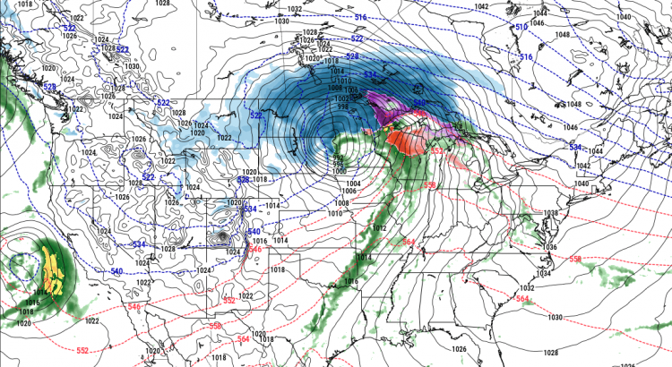
The major story here is the significant winter storm set to impact Southern Manitoba on Christmas Day.
The system is currently develop off the western coast of North America. This satellite animation, taken from midnight last night, shows the long-wave trough that will evolve into a major winter storm beginning to dig southwards as it approaches the western United States. At this point, it looks like snow will intensify through the day on Sunday, with the most potent part of the storm impacting the Red River Valley roughly from 12PM Christmas Day through 12PM Boxing Day.
If you have travel plans for Christmas Day or Boxing Day, this storm will almost certainly disrupt them.
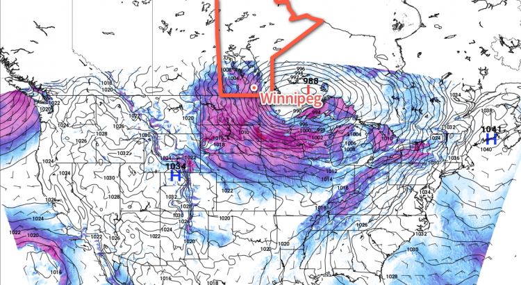
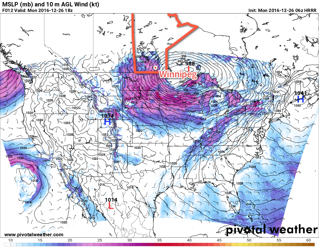
Christmas Day will start with some light snow over the Red River Valley that will intensify rapidly midday as a very potent low pressure system lifts northwards into North Dakota & Minnesota. The heaviest snow will move in by Sunday evening and persist until late Monday morning. By all indications, the snow will be relentless on Sunday night with rapid accumulations. Through this period, the wind will also be increasing out of the northeast to 40-50 km/h. The heavy snow overnight combined with strong winds will produce blizzard conditions through the Red River Valley with zero or near-zero visibilities. There is a high likelihood that most highways will be closed through the night.
The wind and snow will taper off on Monday. Fortunately, without a potent high pressure system building in from the northwest, a weak trough line hanging back across the province from the low will break up the strong winds. This should limit the period of worst travel conditions, with it seeming likely that by Monday afternoon highway travel will be possible again, although likely still slow.
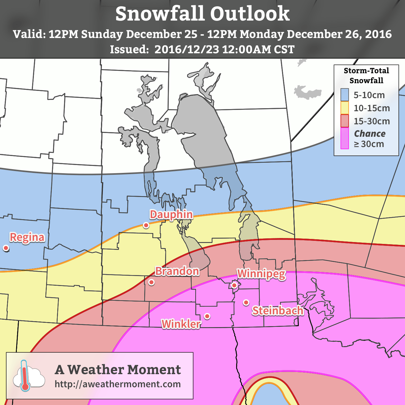
AWM Snowfall Outlook for December 25-26, 2016
When all is said and done, the snowfall from this system should be quite impressive. Widespread amounts of 15-30 cm will be seen across the region, with areas south of a line running roughly from Pilot Mound through Winnipeg and Pinawa having the chance of seeing snowfall totals creep above 30 cm. At this point it looks like 30-35 cm would be the upper end of the potential snowfall totals, but there is high confidence in amounts of 20-30 cm.
Light snow and flurries may linger through the remainder of boxing day before gradually tapering off overnight or early on the 27th.
Winnipeg’s seasonal daytime high is currently -12°C while the seasonal overnight low is -22°C.
Temperatures will remain above-normal through the second half of the week in what has been an extremely abrupt transition from 10 days of below-normal temperatures when the temperature soared 29°C from a low of -30.5°C on Sunday morning to a high of -1.5°C on Monday afternoon. Other than some brief snow early today, the remainder of the work week will be quite pleasant with a fair amount of sunshine on tap. Christmas, however, may end up being notably worse with a second major snowstorm for December possible.
This morning will bring some light snow to Winnipeg as a shortwave rolls through the Red River Valley. The snow should taper off by mid-morning with accumulations anywhere from 1-2 cm along the Trans-Canada Highway up to 5-6 cm near the U.S. border. As the snow moves out, the cloud will break up and we’ll head into a fairly sunny afternoon with a high near -7°C. Winds will become westerly behind the low to around 20-30 km/h with some gusts on top of that. Expect the winds to continue overnight as skies remain mainly clear and temperatures drop just a couple degrees to a low near -9°C.
Thursday will be a beautiful December day with just a few clouds around and a high near -2°C. Winds will continue at 20-30 km/h, however they will be more southwesterly than westerly. Winnipeg will see a bit of overnight cloud as temperatures dip to a low near -8°C.
Winds will continue out of the west to southwest on Friday as temperatures climb to a high near -5°C under partly cloudy to mixed skies. Skies will be mixed to cloudy on Friday night with a low near -14°C.
Christmas Blizzard Possible
Long-range models have been very consistent in producing a very potent winter storm over Southern Manitoba, the Dakotas, and Minnesota beginning overnight on Christmas Eve and continuing through Christmas Day and into Boxing Day.
There is still significant uncertainty in areas that will be impacted by this storm. The only confidence at this point is that a major winter storm will likely occur somewhere in Central North America on Christmas.
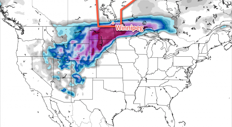
While the location of the system differs between models, a common theme is that all are forecasting 20-50 cm of snow in the worst-hit areas of the storm.
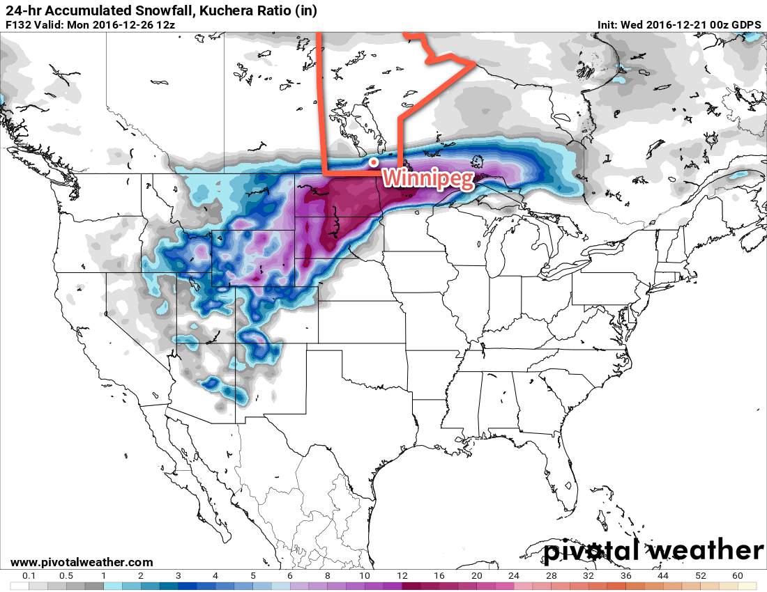
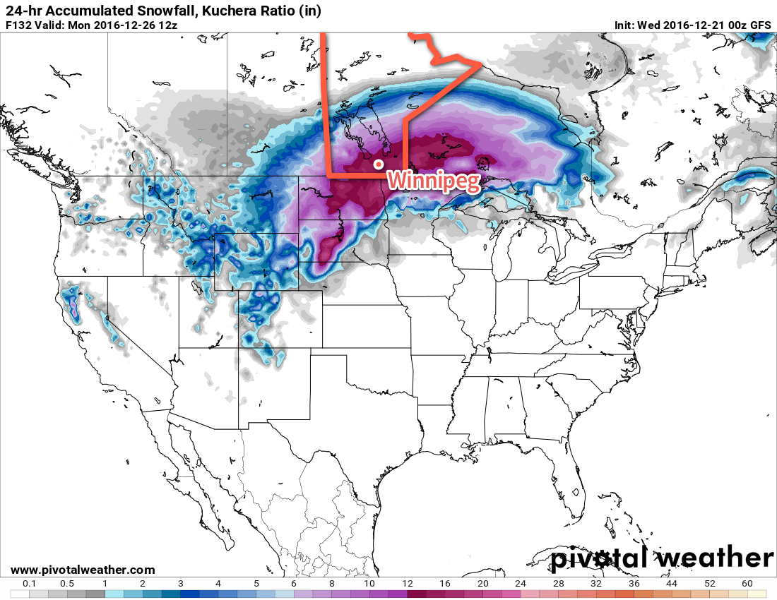
GDPS accumulated snowfall between 6AM Christmas Day to 6AM Boxing Day.
GFS accumulated snowfall between 6AM Christmas Day to 6AM Boxing Day.
Shown here are the Canadian (GDPS) and American (GFS) long-range forecasts for snowfall accumulated in a 24 hour period between 6AM Christmas Day and 6AM on Boxing Day. Both systems have a core of heavy snowfall greater than 30 cm, however where that occurs is in different places and across varying swath widths.
In general, I’m more partial to the GDPS solution as it creates a sharp deformation zone along the northern track of this system (which tends to happen) and concentrates the heaviest snow through a smaller corridor. Both these features are more physically realistic. That does not mean that I think the GDPS is right, though. Just that it seems to have a slightly more realistic handle on this system. Should the GDPS solution come to fruition, the biggest challenge would be where exactly that northern edge of the precipitation sets up.
While it’s too early to suggest any concrete plans, it would be prudent to have a “Plan B” ready if your Christmas involves travel. The heavy snow will be accompanied by strong northerly winds, likely producing widespread blizzard conditions. In areas hit by this storm, highway travel will likely be nearly impossible and air travel will likely be heavily delayed or cancelled. It seems fairly likely that travel through North Dakota and Northern Minnesota will be hazardous to impossible on Christmas Day. If you are scheduled to travel on Christmas day, it may be prudent to bump your travel day up to the 24th instead of the 25th, particularly if you’re travelling to the United States. Travel conditions will likely improve in the second half of the day on Boxing day.
If this storm materializes, it would be just 19 days after the worst winter storm in nearly a decade dumped 25-40 cm of snow across the region. Having two snow storms that produce over 20 cm of snow in a single month is rare; the last time there were two events of that magnitude was December of 1909, when the first 7 days of the month produced 70.9 cm with snowfalls between 5-19 cm each day.
We’ll be watching this storm as it develops and have a full weekend forecast on Friday.
Winnipeg’s seasonal daytime high is currently -11°C while the seasonal overnight low is -21°C.