This week will remain cold as arctic air continues to spill down from the north.
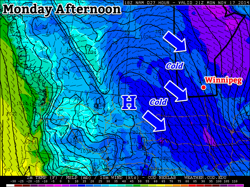
A northwesterly flow will continue to bring cold weather to southern Manitoba on Monday
Monday
Monday
-8°C / -14°C
Mix of sun and cloud with chance of flurries
Today will be cold and breezy. Temperatures in the morning will be in the minus teens, rising into the minus single digits by afternoon. Skies will be a mix of sun and cloud with chance of light flurries. The wind will be from the north-west at 20-30km/h.
Tuesday
Tuesday
-7°C / -10°C
Mix of sun and cloud with chance of flurries
Tuesday will be slightly warmer than Monday, but not by much. High temperatures will once again be in the minus single digits, once again under a mix of sun and cloud. There will also be a chance of light flurries throughout the day. Winds will be breezy and from the south.
Wednesday
Wednesday
-9°C / -18°C
Mainly cloudy with flurries
Wednesday looks to be a fairly miserable day. High temperatures will be near the -10C mark, with a gusty north-west wind and flurries. This means blowing snow is likely in open areas, similar to the conditions experienced on Sunday. Winds speeds of 40km/h gusting to 60km/h are expected.
Long Range
The long range forecast calls for continued cold weather. Weather models suggest that we’ll see below-normal weather persist for at least another week. Unfortunately, it looks like winter is here to stay, like it or not.
Windier, snowier weather is on the way for Winnipeg and the Red River Valley, marking the start of a large-scale pattern shift which will bring the latest – and hopefully last – deep freeze to an end and allow more seasonal weather and temperatures to take hold.
Wednesday
-9°C / ⇑ -6°C
Windy & cloudy. Blowing snow possible. Snow in the afternoon.
Thursday
-1°C ⇓ / -18°C
Snow ending midday; breezy with temperatures falling in the afternoon.
Friday
-12°C / -20 to -25°C
Mainly sunny.
A Windy, Snowy Shift
Warmer air trying to build its way into the Red River Valley will result in increasing southerly winds today. By early this afternoon, winds will be quite strong out of the south at 40-50km/h with gusts as high as 70km/h. These strong winds – coupled with a fairly deep boundary layer – will likely produce fairly widespread blowing snow in the Red River Valley. It’s severity may be limited by relatively mild temperatures, however it’s best that anyone travelling on area highways be prepared for poor driving conditions.
Warmer air at 850mb (denoted by the yellow/red colours) will be pushing northeastwards over the next 24 hours.
By late in the afternoon, the upper-level portion of the warm front will be approaching the Manitoba border. A strengthening jet[1] overriding the 850mb baroclinic zone will provide a fair amount of isentropic lift. As the jet intensifies, as will the area of light snow pushing into Parkland Manitoba this morning. It will progress eastwards through the day and push through the Interlake and Red River Valley mid-to-late this afternoon.
It seems likely that Winnipeg will see around 2cm of snow that falls as a fairly intense, but short, burst. Areas south of the city will be more hit and miss as to whether or not snow falls. The safe thing to say is that you’re more and more likely to see snow the further north you are in the valley.
By evening our temperature will climb up to our daytime high of about -9°C. Overnight will bring the continued chance for flurries/light snow while winds diminish somewhat and temperatures continue to rise to around -7 or -6°C here in Winnipeg.
Expected storm-total snowfall by Friday morning. Snow will fall in 3 main batches.
Thursday looks to bring more snow to Winnipeg & the Red River Valley as a clipper system races along the Canada-US border. Snow will move in fairly early in the day, spreading eastwards along the Trans-Canada corridor into Winnipeg, and end early in the afternoon. In total, around 5cm is likely to fall through the morning hours – with a little less to the south of Winnipeg – while accompanied by breezy winds out of the south at around 30km/h. Winds will become gusty out of the NW at 30-50km/h in the afternoon as the system tracks off to our east.
Temperatures will climb to a positively balmy -2 or -1°C by midday before the northwesterlies begin drawing in cooler air.
Flurries & Cooler
Thursday night will bring a good chance of seeing some flurry activity as another ridge of high pressure builds in from the NW and some favourable snow-making air slides southeastwards through the region. Any accumulations would amount to only a couple cm at most, and through the night the clouds will break up and we’ll be left with partly cloudy skies by Friday morning.
Friday itself will bring cooler temperatures with a high of only around -12°C and light winds. Some cloud cover Friday night will help temperatures from dipping too much, with overnight lows dipping just below -20°C.
Spring Ahead?
Hope finally lies in the long-range models. Almost all are showing a high probability of a return to seasonal temperatures[2] within the next 2 weeks. No significant cold snaps are in the foreseeable future, and with the sun getting stronger and stronger and the days getting longer and longer, it doesn’t seem likely that we’ll see any more brutal cold snaps for the miserable winter of 2013-2014.
Don’t forget that this coming Sunday, March 9th at 2:00AM we get to do that wonderful[3] tradition of changing our clocks! We spring forward an hour, so it’ll be time to cash in that extra hour you banked way back in the fall!
A “jet” is a narrow ribbon of strong winds aloft. ↩
Which will be for daytime highs near -3°C and overnight lows near -13°C. ↩
A deep trough of cold air anchored over Hudson Bay will lock Southern Manitoba into a strong northerly flow that will keep us stuck in abnormally cold weather well into March. This latest blast of cold weather will ensure that the winter of 2013/2014 ends up as the coldest in 35 years[1] and as one of the 15 coldest winters on record[2].
Wednesday
-17°C / -34°C
Chance of morning flurries, then very windy w/blowing snow.
Thursday
-21°C / -26°C
Sunny. Increasing cloud & flurries overnight.
Friday
-21°C / -34°C
Flurries ending midday then clearing.
The Red River Valley is in for a rude return to the deep freeze today as a cold front rips through the Red River Valley bringing very strong winds with it. There’s a very slight chance of some light flurries in this morning’s cloud but it’s likely any precipitation that might develop will remain north or east of the valley. The bigger story is the cold front that will push through around lunch time today.
A deep unstable layer will develop this afternoon in the wake of the cold front.
The passage of the cold front will clear out the skies but bring with it very strong winds, increasing out of the north/northwest to 50km/h. A deep layer of instability, shown on the right in the forecast sounding, will work in two ways:
It will promote gusty winds which will mean in addition to the sustained winds at 40-50km/h, it’s quite likely we’ll see gusts in the 60-70km/h range.
The instability will help “loft” ice crystals and snow which is helpful in generating blowing snow.
Other than making it feel miserably cold, the wind will work together with the relatively dry snowpack in the area to produce blowing snow. I’m unsure of exactly what the snowpack surface’s nature is right now, but I think it’s safe to say that with winds as strong as we’ll see, some blowing snow is inevitable. I don’t foresee a full-scale blizzard or anything of the sort, but localized white-out conditions are certainly possible. If you’re travelling on area highways this afternoon, be aware of the potential for poor driving conditions.
The winds will ease off through the night as an Arctic ridge of high pressure pushes into the region. Temperatures will plummet close to -35°C through the Red River Valley by tomorrow morning as we become entrenched in bitterly cold air once again.
Tomorrow will bring mainly sunny skies, relatively light winds and a high near -21°C. A weak inverted trough will begin pushing into Southern Manitoba late late in the day and will spread cloud and light flurries into Winnipeg and the Red River Valley overnight. Temperatures will drop only to around -25 or -26°C overnight thanks to the cloud cover.
Friday morning will see the light flurry activity tapering off with clearing skies towards midday as the trough pushes off to the east. With the sunshine will come wind once again, with north/northwesterly winds at 30-40km/h picking up through the afternoon. We’ll climb once again to around -21°C as a high
Entrenched
The NAEFS 8-14 day temperature outlook.
Buckle up for the long haul; the cold air will be settling into the region for an extended stay. All long-range outlooks – including the NAEFS above – are forecasting below-normal temperatures into the second week of March. Of note is how far below-normal we’ll be this week. The seasonal high for this time of year is around -6°C, and with forecast highs of -21°C, we’ll be some 15°C below normal.
So keep the long johns out, plug in the car and keep warm!
Well, it was nice while it lasted. Get settled in for another long stretch of below-normal temperatures.
Friday
-14°C / -20°C
Windy with local blowing snow; chance of flurries.
Saturday
-14°C / -21°C
Breezy with mixed skies.
Sunday
-17°C / -23°C
Mainly sunny.
Today will be the most unpleasant day of the week with strong northwesterly winds at 40-50km/h making our high of -14°C feel more like the mid-minus-twenties and producing local blowing snow through the Red River Valley. Winnipeg will see mixed skies which will work in tandem the low-level temperature profile to produce a chance of some scattered light flurry activity. The strong winds will persist into the evening and slightly ease overnight as we head to a low of about -20°C.
Saturday will bring mixed skies once again with a high near -14°C. Winds will be lighter than today, but still fairly breezy at 20-30km/h. Skies will clear late in the day as we head to an overnight low near -21°C.
Sunday will bring mainly sunny skies and a cooler high of only around -17°C[1]. The winds will be relatively light and we’ll drop down to about -23°C Sunday night.
Winter Returns
NAEFS 8-14 Day Temperature Outlook
The immense low pressure system that is pushing northwards through the eastern half of Canada will end up re-establishing a large, cut-off low pressure system over Hudson Bay that will lock the Eastern Prairies into a strong north/northwesterly flow. This will work to entrench an Arctic air mass over the region which will result in below-normal temperatures at least until the end of February.
At this point, it looks like it may not be until the second week of March until the icy grip loses it’s hold over the region, but that’s a long way off and I don’t put a lot of faith in those sorts of forecasts. Safe to say we’re going to see another stretch of relatively dry, cool weather through the end of the month.
This is around 10°C below our seasonal daytime high of -7°C for this time of year. ↩


