Temperatures Return to Seasonal Values in Winnipeg

The recent cold snap is coming to an end as temperatures moderate back towards seasonal values, but with that will come plenty of cloud.

RDPS 10m Wind Forecast valid 00Z Sunday January 21, 2023
Moderate southerly return flow winds will develop over the Red River Valley on Saturday.

Heading into the end of the week, the last remnants of the Polar Vortex that have been lingering over Manitoba will finally shuffle off to the east. This will ease the cold over the region and allow temperatures to recover towards seasonal values. As the weekend progresses, a warm front will push off the Alberta Foothills into southern Saskatchewan while the Arctic front re-strengthens in the north and drops into the northern Prairies.

In Winnipeg, Friday will bring conditions on the cloudier side with a high in the mid-teens today. Like the past couple days, there’s a chance the cloud could be accompanied by light snow. The last of the cold air from the Polar Vortex will linger over the province tonight and keep overnight lows down tonight. The cloud cover will likely break up overnight and allow temperatures to dip into the -30 to -25 °C range.

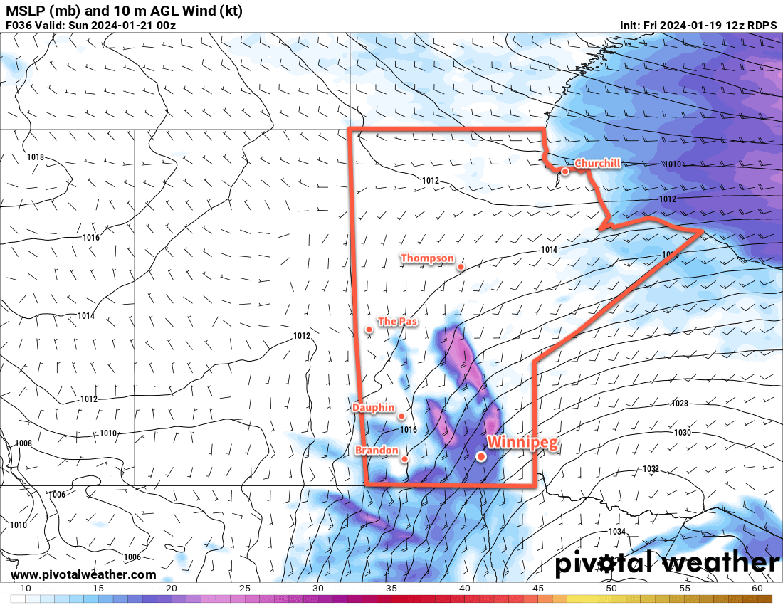
More cloud will push into the region on Saturday as the warm front creeps across southern Saskatchewan. The return flow from a departing high will intensify over the Red River Valley, strengthening southerly winds up to the 40 to 50 km/h range through the day. Highs will climb back to around -15 °C, but wind chill values will be notable making it feel closer to -25. In addition to the chill, those southerly winds will likely produce areas of blowing snow through the Red River Valley; any blowing snow would likely be at its worst from the early afternoon to the evening.

Those winds will begin to ease on Saturday evening as the warmer air finally reaches the valley. Light snow will likely move through overnight with temperatures staying steady in the mid-minus teens.

Winds will continue to ease on Sunday with cloudy conditions across the Red River Valley. Highs will creep upwards again, likely reaching around -10 °C in Winnipeg and area. More light snow is possible on Sunday night with temperatures dipping back towards -15 °C.

Long Range Outlook

There is disagreement between weather models on how next week will turn out. Canadian weather models are pushing Arctic air further south and giving Winnipeg highs in the -15 to -5 °C range through the first half of the week, while other models bring highs of -10 to 0 °C into the region next week.

Either way, plenty of cloud cover will come along with that milder pattern. The warmer weather will likely stick around to the end of the week.

Today’s seasonal daytime high in Winnipeg is -13 °C while the seasonal overnight low is -24 °C.

Spring Storm to be Followed by Much Warmer Weather

A Colorado Low is on the way to Southern Manitoba and will bring snow and blowing snow to the region beginning Tuesday night. This storm will exit the region on Thursday, and after a couple cool days much warmer spring weather will move into the province.

Weather alert map valid 0827Z Tuesday April 4, 2023
Winter storm warnings are out across southern Manitoba (red on the Canadian side of the border) with blizzard warnings across much of the Northern Plains of the United States (red south of the international border) for a potent spring storm moving into the region. Image valid at 8:30 AM Tuesday March 4, 2023.

A Colorado Low is organizing south of the border that will bring a blast of winter weather to parts of southern Manitoba. It has already begun to spread a band of snow through South Dakota that will lift north-northeast through the day today.

In Southern Manitoba, the snow will approach the southern border by evening, then spread into the province overnight. Light snow will fall across southwest Manitoba, with heavier snow pushing into the Red River Valley and southeastern corner of the province. The Trans-Canada Highway corridor in the RRV will likely receive 5–10 cm of snow by Wednesday morning with higher amounts of 10–20 cm to the south and southeast.

Snow will continue across the Red River Valley and east on Wednesday with another 5 to 10 cm likely in most regions. The snow will finally begin to taper off on Wednesday night. By the time all is said and done, much of southern Manitoba will receive 15 to 25 cm of snow; amounts will drop off quickly west and north of a line running roughly from Pilot Mound to Berens River. The heaviest amounts could reach into the 30 to 40 cm range with the highest risk for that much snow focused in two locations: Sprague and the southwest Red River Valley, particularly in the areas closer to the western escarpment.

RDPS Total Accumulated Snowfall Forecast (10:1 SLR) valid 12Z Thursday April 6, 2023
Much of southern Manitoba will see notable snowfall accumulation as the region is clipped by a Colorado Low Tuesday night through Wednesday.

In addition to the snow, moderate northwesterly winds will develop on Wednesday, bringing areas of blowing snow to the Red River Valley. In combination with the moderate falling snow, expect poor travel conditions across the region, including southward into the United States, Tuesday night through Thursday.

Please refer to the Meteorological Service of Canada for the latest weather alerts for Manitoba.

Temperatures will run seasonably cool through the storm with highs in the -5 to 0 °C range over the next few days. Lows will generally sit in the -5 to -10 °C range, except for Thursday night where clear skies will combine with the fresh snow to send lows into the mid-minus teens.

Long Range Outlook

Probably just as notable as all the snow coming over the next couple days will be the forecast for the weekend. As the Colorado Low pushes northwards, it will dislodge the Polar Vortex and send it further north, finally loosening its influence over the eastern Prairies. A more zonal flow aloft will develop over the region, and much warmer Pacific air will begin to sweep across the Prairies this weekend.

The extensive snow pack over the region will limit daytime highs into the low to mid-single digits. If the ground were completely bare and skies were sunny, daytime highs in the mid-teens could be possible Sunday into Monday; alas. But in addition to temperatures climbing above freezing, this push of warm air will also likely send dew point values above 0 °C as well.

Dew point values rising above freezing greatly enhance how quickly snow can melt, and although the warmer weather will be welcome, it may result in a lot of melting from Saturday through Wednesday. Given the pre-existing concern in Manitoba’s flood forecast, this could result in a higher flood risk for some areas. Be sure to watch for updated Manitoba Flood Forecasts and Reports if you are concerned that you may be impacted by a quick melt.

Today’s seasonal daytime high in Winnipeg is 7 °C while the seasonal overnight low is -4 °C.

Breezy With Light Snow Today, but Spring Weather Returns Soon

It will be a bit of an unpleasant day in Winnipeg today as breezy northerly winds combine with light snow and cooler temperatures. Nicer weather is on the way soon, though, with plenty of sun and warming temperatures through the weekend.

RDPS 10m Wind Forecast valid 21Z Friday March 17, 2023
Moderate northerly winds will develop over the Red River Valley for Friday afternoon.

Winnipeg will find itself on the back side of a rather potent low pressure system moving from the United States into Ontario today. The region will see breezy northerly winds up to 40 gusting 60 km/h today, driven by the passing low and the approach of an Arctic high from the northwest. Along with that, a weak inverted trough slumping southwards will bring some light snow to the region. These two things will combine to produce some blowing snow in the region, but will mainly be limited to outlying areas and southwards through the Red River Valley. Temperatures will struggle to reach even -10 °C today, and head back into the mid-minus teens overnight. The wind will be stronger this afternoon, then ease overnight.

Skies will clear for Saturday, leaving behind sunny skies for the weekend. Temperatures will climb into the -5 to -10 °C range on Saturday and then into -5 to 0 °C range on Sunday. Overnight lows will sit in the -10 to -15 °C range. Of note, though, is that with full sunshine in mid-March, areas that aren’t just barren snow-covered fields will definitely see temperatures higher than this. It won’t be surprising for many parts of the city to see temperatures in the -5 to 0 °C range this weekend and to see plenty of melting despite the sub-freezing air temperatures.

Long Range Outlook

The start of next week will cool just a bit, then warm up again heading into mid-week. Some snow is possible on Wednesday as a disturbance moves through the region, but it will also likely bring a shift to daytime highs around freezing.

With no major snowfalls on the horizon and several days of sunshine ahead, it will continue to gradually feel more spring-like in Winnipeg; enjoy the pleasant weather this weekend!

Today’s seasonal daytime high in Winnipeg is +0 °C while the seasonal overnight low is -11 °C.

Snow Finally Arrives in Winnipeg

After a few dud events over the region snow is finally on its way to the Red River Valley, but exact amounts are still uncertain.

RDPS 10m Wind Forecast valid 18Z Saturday March 11, 2023
A stubborn Arctic High will remain entrenched over northern Manitoba as the next disturbance brings moderate easterly winds to the Red River Valley.

It’s been a complex weather situation over the Red River Valley over the past few days. The snow we earlier this week did develop as expected, and in fact, over the past few days was visible on RADAR as it streamed northwards over the region. But a stubborn Arctic High entrenched over northern Manitoba complicated things substantially.

This high was pumping copious amounts of cool, dry air into the northerly flow over the region which was pushed underneath the snow lifting northwards. This dry air ended up evaporating most of the snow before it managed to reach the surface. As a result, we saw little to no snow through the region over the past few days despite it falling a few thousand feet above ground.

This setup continues today, with cloudy skies and a slight chance of flurries. Temperatures will reach a high near -2 °C this afternoon, the d up down into the -5 to -10 °C range tonight.

The third system we talked about in our last forecast is now developing in the west and will begin bringing snow to Saskatchewan tonight and then spread across Manitoba on Saturday. The snow will begin in Winnipeg mid- to late-morning on Saturday and persist to the evening before beginning to ease. Moderate easterly winds up to 40 gusting 60 km/h will accompany the snow, producing blowing snow across the region in the afternoon.

There is still some uncertainty with snowfall totals. Like with the previous systems, weather models have struggled to fully capture the impact of the Arctic High entrenched over the Northern Prairies. As a result, model runs have been slowly shifting the expected track of this system further south over the past few days, reducing the amount of snow over many parts of the Prairies. But the models do seem to be stabilizing their tracks, and it looks reasonable at this point that Winnipeg will likely see 5 to 10 cm of snow with this system.

ECMWF Accumulated Snowfall Forecast valid 00Z Friday March 10, 2023 to 18Z Sunday March 12, 2023
The ECMWF snowfall forecasts have begun to stabilize with 5 to 10 cm of snow for Winnipeg and higher amounts to the south and west.

Further south, snowfall totals could rise quickly, especially along the western escarpment where snow will be enhanced by the persistent easterly winds. Heading southwards through the Red River Valley, accumulations will likely increase into the 10 to 20 cm range. The higher snowfall amounts coupled with the strong winds could result in very poor travel conditions, particularly near the International Border, on Saturday afternoon.

Temperatures will hover around -6 °C on Saturday, then dip down close to -10 °C on Saturday night.

Some light snow will linger through Saturday night and then taper off on Sunday. Temperatures will linger in the -5 to -10 °C range through the day under cloudy skies, then dip to a low in the -15 to -20 °C range overnight as skies clear.

Long Range Outlook

In the wake of this system, skies should clear as cooler air floods into the region. Seasonably cool temperatures will move into the region to start the week with highs generally in the -5 to -10 °C range.

Another disturbance will move into the region mid-week and could bring some more accumulating snow to the area along with warmer seasonal temperatures.

Today’s seasonal daytime high in Winnipeg is -2 °C while the seasonal overnight low is -12 °C.