What a week it has been! Temperature records have fallen, our snow cover has disappeared, and thunderstorms are in the forecast – the question is what next?
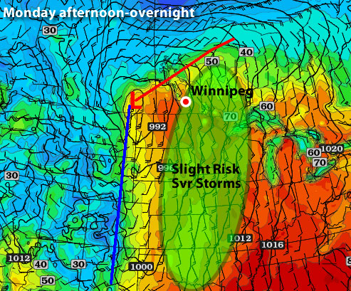
The light green region shows where there is a slight risk for severe thunderstorms on Monday
This week will start out on a warm and possibly stormy note. Monday’s temperatures are expected to be in the low to mid twenties across Southern Manitoba with a risk of thunderstorms. If Winnipeg records a high temperature on Monday that is greater than +23.3C the city will record a new all-time record high for the month of March. The previous all-time record high of +23.3C was set on March 27, 1946. On Sunday Winnipeg set a new record for the earliest ever occurence of a 20C high temperature, beating the old record of +22.8C set on March 23, 1910.
| Day |
New
Record |
Old
Record |
Previous
Record Year |
| Sun Mar. 11 |
12.8°C |
12.5°C |
1981 |
| Mon Mar. 12 |
9.7°C |
7.2°C |
1922 |
| Thurs Mar. 15 |
14.4°C |
11.1°C |
1927 |
| Fri Mar. 16 |
19.9°C |
12.4°C |
1981 |
| Sat Mar. 17 |
19.2°C |
12.8°C |
1938 |
| Sun Mar. 18 |
20.9°C |
14.4°C |
1910 |
| Mon Mar. 19 |
23.7°C |
18.9°C |
1938 |
Table of daily record high temperatures over the past week.
As you may have noticed on Sunday, the humidity has risen significantly in the Red River Valley and South-Eastern Manitoba. When that extra moisture in the air is combined with warm temperatures, thunderstorms become possible. A strong jet stream is currently in place over Southern Manitoba, setting the stage for some potentially strong storms later on Monday afternoon into the evening. There will be a “lid*” over the atmosphere on Monday preventing storms from developing earlier in the day. This “lid” may or may not come off the atmosphere later on Monday. Whether or not the “lid” comes off will determine if storms can develop. Any storms that form shouldn’t be particularly strong, with the strongest storms only being marginally severe at best. However, with the way this March has gone it is best to assume that anything can happen – including stronger than expected thunderstorms.
The rest of the week looks a bit more “normal”. Actually temperatures will remain well above-normal but will seem more reasonable for this time of year. It looks like most days this week should feature high temperatures in the low double digits. As a result more temperature records will be threatened over the coming days, but they won’t be broken by the huge margins seen on the weekend. It doesn’t look like any more 20C days are imminent, but we certainly could hit 20 degrees again before the month is over.
In the long range models show continued warm weather through the end of March. With our snow cover gone it will be very difficult for conditions in Southern Manitoba to reach below-normal values. We’ll have to wait until our seasonal averages rise by several degrees before below-normal weather is even possible again. Bear in mind that above-normal temperatures don’t necessarily give way to beautiful weather conditions all the time. Models do hint at less settled weather over the next 7-10 days, which means we could get our first significant rain storm of the season (fingers crossed that it doesn’t turn into a snowstorm!)
Here is Environment Canada’s statement regarding broken temperature records on Sunday:
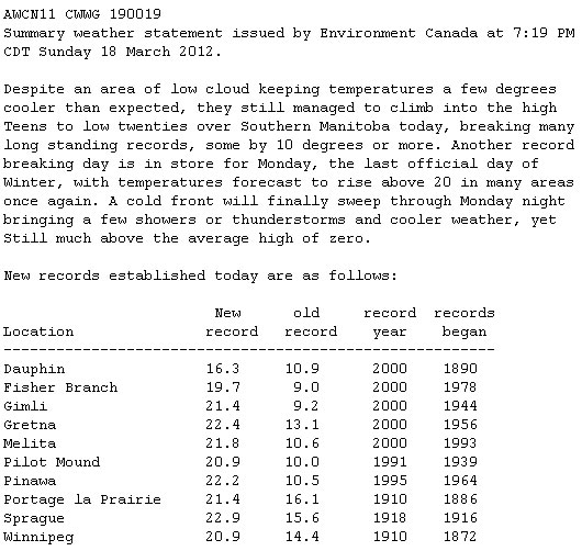
New high temperature records set on March 18, 2012
*A “lid” being on the atmosphere is simple way of referring to atmospheric capping. Capping is when there is warm air above the ground which prevents air near the surface from rising. We know that warm air rises and cold air sinks, but warm air only rises if it is warmer than the air around it. Therefore if the air at the surface is relatively warmer than the air aloft it will rise and if the air aloft is relatively warmer than the air at the surface the surface air won’t rise. On Monday the air aloft will be relatively warmer than the air at the surface for most of the day. Storms will only develop if colder air moves in aloft allowing the surface air to rise up high into the atmosphere. This may or may not happen, causing the thunderstorm forecast to remain uncertain.
Elsewhere in Weather News
Record Breaking Heat Wave Across the United States
The heat wave that currently has Southern Manitoba feeling more like May than March has also taken hold of much of the United States this past week. The unusual warmth is caused by a large surge in the jet stream over most of the US Plains, Midwest and East Coast. The jet stream, which acts as a fence between the cold air masses and warm air masses, is part of the reason why the US is experiencing its first major heat wave of the year. As the jet stream surges in the Plains and East, a trough (dip) in the jet stream over the west coast is bringing unseasonably cold air to the region and much precipitation with it.
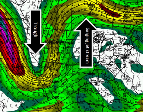
250mb wind speeds, showing the jet stream, Sunday March 18th. (Source: Brad’s Model Viewer/COD)
Since the beginning of March the US has seen more than 1700 new records reached, including some records that weren’t even close to the previous records. Here are some notable ones from this past week across the US:
- International Falls, MN: Previous record = 13°C, New record = 25°C, Average = 1°C
- Marquette, MI: Previous record = 16°C, New record = 24°C, Average = 3°C
- Minneapolis, MN: Previous record = 17°C, New record = 23°C, Average = 4°C
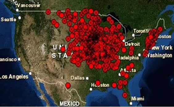
Map showing record highs Wednesday, March 14th. 307 record highs were broken and 97 tied. (Source: National Climactic Data Center)
As the jet stream shifts east early this week the spell of record-breaking temperatures will end for the plains, giving way to strong thunderstorms as the cool air from the west collides with the moist gulf air present over tornado alley. However, the Midwest and East Coast will remain near record breaking temperatures for a couple more days before cooler air arrives (but still above normal) and ushers showers in with it.