On Tuesday a large trough was in place over the eastern half of the US. The longwave trough extended all the way down to the southeastern states and brought adverse weather conditions along with it. This trough did not produce the typical severe weather the southeast would see around this time of the year; thunderstorms and flooding rain, but produced an event featuring snow, ice pellets and freezing rain.
Arctic air flooded in behind the cold front all the way down from Texas to the Gulf of Mexico to Florida, providing good environment for freezing precipitation right behind the front. Freezing rain fell as far south as Pensacola in the Florida panhandle where over 200km of interstate had to be shut down because it was deemed to be too dangerous for travel. The last time Pensacola saw snow was 2010 – it melted the same day it fell. In comparison, Atlanta saw a trace of snow in 2008. This time around the city received 6cm, which snarled traffic on the commute back home. Officials decided to not cancel schools and students were stranded in schools and buses overnight until the next morning. Commuters were in the same situation, being stranded on roads overnight as many commuters are not accustomed to winter weather leading to many accidents. The sub-freezing temperatures across the Deep South also wreaked havoc, bursting water pipes above ground.
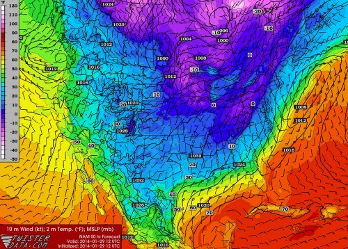
Wednesday morning surface temperatures. Freezing temperatures can be seen reaching all the way down into Mexico and the Deep South. (Source: Twisterdata)
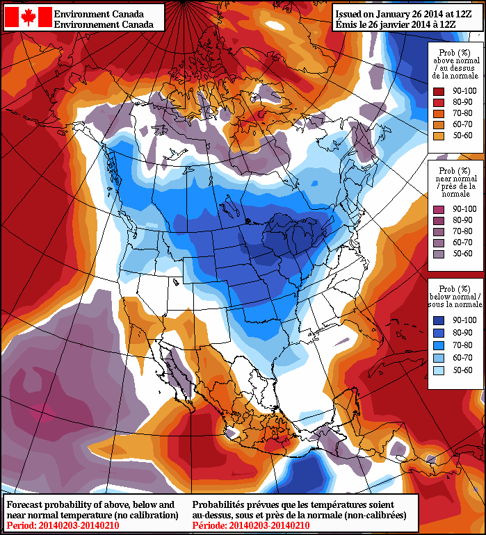
Medium range models continue to show cold air entrenched across the Canadian Prairies and most of the United States, even infiltrating into the Deep South again next week. A persistent ridge off the West Coast, partially associated with the well above normal temperatures in the North Pacific, can be blamed for the persistent troughing and Arctic air over Canada and US the past few weeks. Longer range models do show the ridge eventually breaking down in a week but this remains to be seen as it’s still a long ways out.
This week will see a return to frigid weather, the likes of which we haven’t seen consistently since early this month.
Monday will be very cold as an arctic air mass remains entrenched over southern Manitoba
Monday
Monday
-25°C / -33°C
Mainly Sunny
Monday will feature extreme cold weather. High temperatures in Southern Manitoba will be in the mid minus twenties, with wind chill values in the upper minus thirties or lower minus forties for much of the day. Temperatures will plunge on Monday night, as will wind chills – don’t forget to plug in your car!
Tuesday
Tuesday
-21°C / -25°C
Mainly Sunny
Wake-up temperatures on Tuesday will be brutal. Air temperatures will be in the low to mid minus thirties, with wind chills making it feel more like the mid minus forties. However, it appears that we will warm up a fair bit during the day on Tuesday. It won’t be warm by any means, but temperatures should climb close to -20C by late afternoon. A southerly flow will develop on Tuesday night, preventing another night of extreme cold.
Wednesday
Wednesday
-11°C / -25°C
Mainly Cloudy. Chance of Flurries.
Wednesday should be the warmest day of the week, as that southerly flow temporarily brings some relief to this cold snap. Daytime highs on Wednesday look to be in the low minus teens, which will make it feel like relatively warm day. Unfortunately, another cold front will blow through Southern Manitoba during the day on Wednesday, bringing a renewed push of arctic air. We may see a bit of snow on Wednesday due to a passing weather system, but amounts will be small.
Long Range
The NAEFS model suggests that we’re in for a prolonged cold snap.
The long range forecast looks really bad. For the first time since the beginning of this month there are strong indications of another prolonged cold snap. Long range models suggest this cold weather will last into the beginning of February for sure, but perhaps longer than that. We’ll just have to hope the models are wrong.
Snowstorm Sweeps across Northeast US, Cold Temperatures Follow
A powerful low off the Atlantic coast impacted the Northeast US this past Thursday/Friday bringing heavy snow to the region and blizzard-like conditions. Blizzard warnings were issued for Cape Cod and surrounding regions as winds howled around 70km/h and heavy snow fell. Conditions did improve snow-wise late Friday, but very cold Arctic air ushered in behind the low was of concern. In total, about 4,500 flights were cancelled out of New York alone, causing problems for holiday travelers. Schools and most government offices were closed in Washington DC on Friday due to the adverse weather conditions. Boxford, Mass appeared to be hardest hit with snowfall totals around 60cm, however, Boston was not far behind with 45cm followed by New York’s 25cm. On Friday night 16 deaths had been reported to be associated with the storm.
Temperatures are expected to rebound and warm up for the Northeast as another low pressure system approaches, from the west. It will draw in some warm air; highs Sunday (overnight) are even expected to rise in the (positive) double digits making for a 30°C temperature swing in less than 48 hours for parts of the Northeast.
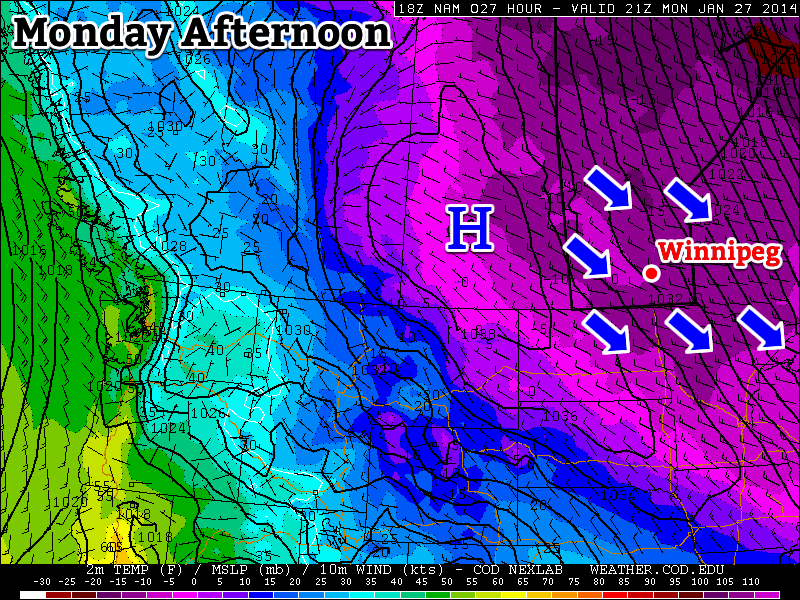
Arctic air infiltrates across the Northern Plains, US Midwest behind the low centered in southern Quebec. Valid Monday morning. (Source: Twisterdata)
Some potentially record-breaking low temperatures are expected on the horizon for the Midwest behind this system though, as the polar vortex pivots all the way down to the Midwest. On Friday the Governor of Minnesota had already cancelled schools state-wide on Monday in preparation for this next potent blast of Arctic air that will make its way east.
Snow will the the story today as another system moves across Manitoba bringing close to 10cm to Winnipeg and lesser amounts southwards towards the International Border. The warm temperatures that we’ll see today will quickly be replaced by one of the most unpleasant cold snaps of the year; while temperatures won’t be the coldest we’ve seen, they’ll be coupled with a strong wind that will produce some of the coldest feeling weather of the winter.
Friday -11°C / -23°C 5-10cm of snow. Windy with blowing snow in the morning and evening.
Saturday -22°C / -33°C Sunny, windy and very cold.
Snowfall accumulations aross Southern Manitoba; totals for the period of Thursday night through Friday evening.
Snow will be the story today as a pair of low pressure systems move in tandem through Manitoba; one in the Northern half of the province and the other travelling near the United States border. They will work together to produce an extremely wide swath of snow that covers nearly the entire province. The heaviest snow will track through the “usual” suspects: Parkland Manitoba (particularly near Dauphin) SE through the Southern Interlake and then off towards Pinawa and into NW Ontario.
Along the axis of heaviest snow, around 10–15cm will fall, with the higher amounts closer to the Ontario border thanks to the merging of the two low pressure systems. Winnipeg will sit right on the southern edge of the axis of heaviest snow, so we’ll likely see total amounts by this evening very close to 10cm. Amounts will taper off relatively quickly as one goes south; areas near the U.S. border will see only around 2–5cm of snow.
In tandem with the snow will be mild temperatures and strong winds. Here in Winnipeg the temperature will climb to a comparatively balmy –11 or –10°C while temperatures in the Southern Red River Valley may see as high as –5 or –4°C. These warm temperatures will be ushered in by the strong winds we’re seeing this morning out of the south at around 40km/h with gusts to 60km/h. This wind will produce blowing snow in open areas of the Red River Valley this morning which will produce near-zero visibilities. As is usual, highways running west-east will be hardest hit. The wind will taper off midday and we’ll see a fairly pleasant afternoon with some light snow, mild temperatures and light winds.
Things will deteriorate quickly in the evening as the cold front slumps southwards. Extremely cold air will begin pushing into the Red River Valley as winds pick up out of the northwest to 30–40km/h with gusts as high as 60km/h. This, combined with the freshly fallen snow, will produce widespread blowing snow through much of the Red River Valley through the evening and overnight hours. Visibilites will be near-zero in some areas and, in general, highway travel will be difficult. If you need to travel tomorrow night, carry a winter survival kit and give yourself lots of time to reach your destination.
Brutal Cold Returns for the Weekend
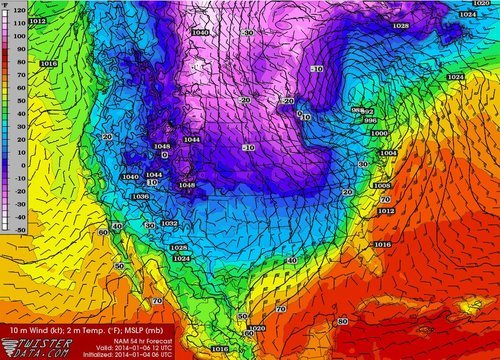
The GDPS 850mb temperatures show an extremely cold Arctic air mass moving over Southern Manitoba this weekend.
After the snow and wind moves out tonight, we’ll be left with absolutely brutal cold moving into the region. Although the temperatures won’t be quite as cold as the last shot we got, they’ll be paired with winds in the range of 15–30km/h which will make it feel significantly colder. The temperature will slowly fall all day Saturday from whatever it is in the morning (close to –22°C or so) until we hit our overnight low on Saturday night of around –33°C. Combined with the wind, it will feel closer to around –45 by early sunday morning.
Sunday will see temperatures recover to around –26°C thanks to a little bit of cloud pushing back into the region from the north. Winds will be 15–20km/h mainly out of the west. We’ll drop to around -32°C on Sunday night under mainly clear skies.