Elsewhere in Weather News: May 17th, 2014

Wildfires Torch California, Helped by Strong Winds and Drought

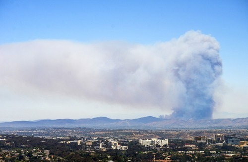
This past week several wildfires have been burning out of control in San Diego County, just north of San Diego. It is not known whether any of the fires were started intentionally or not, however, the weather has played a significant role in hampering firefighting efforts. As of Friday evening there were four wildfires burning in the county which were all over 1,000 acres in size, and only one of these four was above 25% contained. There are two main points to note of as to why weather has played such a significant role in fueling the fires.

A large pyrocumulus cloud could be seen on Wednesday from San Diego looking towards the Cocos San Marcos fire. (Source: Mashable/Kent Horner)

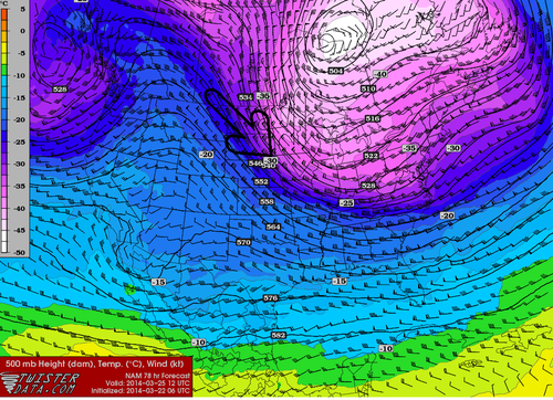
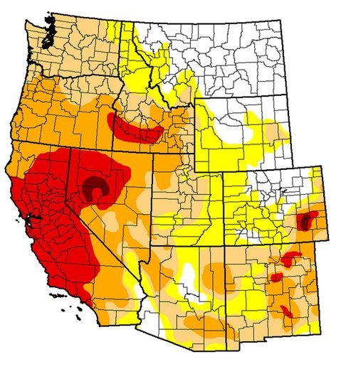
The Santa Ana Winds are the first to have a big impact on wildfires currently burning out of control in Southern California. These winds occur when air blows towards the Pacific Ocean from the mountain ranges to the east. As the air descends the mountain sides it warms and its relative humidity decreases causing for hot and dry winds. This past week, relative humidity as low as 3% was observed by stations in southern California, coupled with winds of 50km/h, this produced prime wildfire conditions. The second reason as to why the wildfires have been difficult to contain is the current drought situation in the region. A large ridge of high pressure has been persistent over the west coast for most of this past winter and part of this spring, making precipitation difficult to come by. The drought index currently indicates that an extreme drought (second highest tier) is occurring in the region where the fires are burning. In turn, the wildfires have little trouble spreading to moisture-starved vegetation and dried out brush.

This weekend offers a mixed-bag to firefighters. Strong winds and scorching temperatures will persist during the day, but winds will now be out of the west causing for slightly moister air coming onshore from the Pacific. Regardless, the Storm Prediction Center maintains an “elevated” fire risk for this weekend.

Elsewhere in Weather News: March 22nd, 2014

Below Normal February Temperatures for most of Continental US; Will Return

What seems to be the winter that won’t give up in Southern Manitoba has not only been persistent in the Canadian Prairies, but also a good chunk of the United States. The central and eastern half of the US has been fairly consistent in staying below normal in February thanks to a persistent trough on the east coast and ridge over the west coast. Consequently, a northwest flow in the upper levels of the atmosphere has established itself over the Northern US Plains and Midwest and, as a result, Arctic highs were continuously helped down into the region. Interestingly enough, central North America has been one of the only regions in the world to experience below normal temperatures in February.

Temperature anomalies across the globe for February, notice the below average in Central/Eastern US, contrasted by the much above normal just to the east, over the ocean. This is caused by persistent troughing on the East Coast. (Source: NOAA)

The pattern, which has not shifted around much this winter, has caused extremes to occur not only temperature-wise but also precipitation wise. The problem is that with the ridge staying put over the area systems have trouble making their way into the region and instead diverted further north. California continues to experience severe to exceptional drought – the highest level of drought, as per the US Drought Monitor. Consequences might not be immediate but could spell trouble once the wildfire season rolls around, and when water reserves literally start to run dry in the state. Currently, about 60% of the state is considered to have an above average risk for wildfires due to the drought, according to NICC.

Sunday night into early next week yet another blast of Arctic air is expected to infiltrate across a good chunk of the United States. In addition to this cold blast, models are showing a potent Nor’easter Tuesday-Wednesday next week blasting through the Northeast US and Atlantic Canada which could drop significant amounts of snow. However, there is a glimmer of hope for the central United States as most models are in agreement that temperatures late next week into next weekend will be either bounce back to normal or slightly above normal.

500mb northwest flow returns to the region this week, shown by the NAM here, on Tuesday morning. (Source: Twisterdata)
Northwest flow returns to the region this week, shown by the NAM here, on Tuesday morning. (Source: Twisterdata)

Elsewhere in Weather News: January 18th, 2014

Severe Californian Drought

A severe drought has settled into a good part of the state of California and is starting to be of concern to residents as numerous brush fires have been sparking up this past week. A strong upper level ridge which has persisted over California for a good part of the past month has diverted all low pressure systems well north into BC. With this, a large area of California has been left dry and drought conditions have worsened significantly in the past month. The Drought Index shows that levels have reached extreme for over 50% of California, including Los Angeles. Los Angeles, on average, receives 80mm of rain during the month of January but they have yet to record any rainfall this January. To make matters worse, no pattern changes are in the forecast; the ridge is expected to remain in place at least until the end of January. Models show no precipitation in the foreseeable future for the southern half of California, which means that Los Angeles has a possibility of going the whole month of January without any precipitation.


Drought Index for the West Coast, ranging from abnormally dry (yellow) to exceptional (dark red). A good chunk of California is under extreme (red). (Source: USDA)

The snow pack in the Sierras has shown telltale signs of drought with only having 20% of the average snow water equivalents for this time (about 25mm of SWE). In this tweet sent out by the Boise NWS a drastic comparison in the snow pack can be seen over the Sierras. If no significant precipitation arrives before spring, California will be setting itself into a long-term drought.

A drought emergency had been issued for California, asking residents to limit their use of water. Bushfires have been flaring up due to the dry conditions, including the Glendora fire which is a fire that started on Thursday and has already burned 1,700 acres east of Los Angeles. Santa Ana winds gusting to 35km/h have been fueling the fire and will continue to do so until tomorrow, making it difficult for crews. Relative humidity in the area has a chance to dip as low as 5% during the day – making for ideal wildfire conditions. This has prompted the National Weather Service to issue a red flag warning east and northeast of Los Angeles.

Elsewhere in Weather News: June 15th, 2013

Colorado’s Black Forest Fire

Residents of Colorado Springs and surrounding areas have been on high alert this past week because of wildfires in the area that are burning out of control. Currently, there are three large fires burning in Colorado. The largest wildfire of the trio is known as the Black Forest Fire. This fire covers about 60 square kilometers and has destroyed about 400 homes already, as of Friday evening. Unfortunately, two people have also perished from this fire. On Friday thunderstorms moved over the area but although they brought much needed rain, they also had undesired effects such as cloud to ground lightning strikes that potentially sparked up new fires. The Black Forest Fire is around 30 percent contained as of Friday evening so firefighters still have quite a bit of work to do this weekend.

The reason for such extreme wildfire events this spring in Colorado can be associated with drought. The severe drought that was seen throughout the US Plains last year and into this spring has shifted slightly further west. Although areas of the Plains have been mostly relieved of drought from thunderstorm activity this spring, Colorado has continued to experience severe to exceptional drought. The town of Colorado Springs is located under extreme drought which translates into little moisture available for vegetation and in consequence, wildfires are easily sparked.

Black Forest Fire

Plume of smoke from the Black Forest Fire threatens homes in the foreground. (Source:Reuters)

Temperatures are expected to remain quite warm with highs in the upper twenties and even low thirties in the area this weekend, not helping the fire risk. There is also a chance of storms. The longer range doesn’t look promising for drenching rains either as a ridge is expected to redevelop in the southern US Plains mid next week.