Elsewhere in Weather News: August 18th, 2012

A Look Worldwide into July, 2012

As reported on Friday, Winnipeg is shaping up to be one of the hottest years since record-keeping began 139 years ago, with July closing out as the 5th hottest month on record for the city. Wondering how the rest of the world faired this past month?

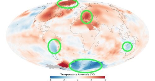
Interestingly, most of the Northern Hemisphere has also experienced extreme temperature anomalies this year. According to the National Climactic Data Center (NCDC), the Northern Hemisphere land surface temperatures this July were 1.19°C above the average, making July 2012 the warmest July in the Northern Hemisphere ever. This year has experienced no shortage of record breaking temps in the Northern Hemisphere – it is now the fourth month in a row that surface land temperature records in this hemisphere have been broken. Canada and the United States have contributed greatly to the record-shattering numbers these past four months but the heat wasn’t confined to North America. South-Eastern Europe has seen conditions almost identical to ours this summer – very dry with record-setting warmth; while Serbia and Bulgaria have been impacted with severe drought this growing season, resulting in severe crop losses. Bulgaria has lost around 10% of its wheat crops due to the sizzling heat, and their maize crops have decimated to the point whereby getting half their average crop will have to suffice. The only countries in the world to have shown significant temperatures below normal this July were Australia, Argentina and parts of the Antarctic.
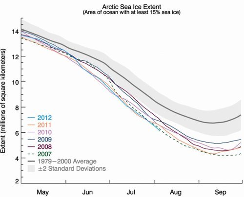
Temperature anomalies July 2012

July temperature anomalies and circled, areas talked about in EIWN. (Source: NASA Earth Observatory)

Precipitation anomalies July 2012

Precipitation anomalies for July 2012 and circled in red is where severe drought is occurring in South-Eastern Europe. (Source: NCDC)

Arctic Melting

In some areas of the Arctic, July temperatures have exceeded 6°C above average. Arctic ice is continuing to melt at a disturbing rate. The expanse of the Arctic sea’s ice coverage is now at its lowest ever at this time of the year, having dropped even further than measurements from the record-setting year, 2007. In July, almost all of Greenland’s entire ice sheet experienced melting – a “rare event” as described by the National Snow & Ice Data Center (NSIDC). To put things into perspective, sea ice used to reach seven million square kilometers in the 1990s at their minimum, while it has only surpassed five million square kilometers once in the past six years (showing a 29% decrease of minimum sea ice extent in the last few decades). This has lead scientists, like Walt Meier, a scientist at NSIDC, to believe that sea ice could potentially be eliminated by the year 2030 if melting continues at this pace. If this does happen, the ice melt could trigger a domino effect: raising ocean levels, releasing methane from frozen soils, and so on.

Sea ice extent graph

Sea ice extent by year. (Source: NSIDC)

Elsewhere in Weather News: May 19th, 2012

Strong Winds, Wildfires Rage On

South-eastern Manitoba has seen its fair share of fires burning this spring but it wasn’t comparable to the conditions experienced this past week in Arizona and Colorado where wildfires are burning out of control across the states. Fanned by very strong southwesterly winds associated with a ridge of high pressure that is strengthening over the west coast, the fires quickly grew out of control in Arizona. Wind gusts of 80km/h were recorded in the area which easily spread the flames and expanded the fire by blowing embers, making it nearly impossible for firefighters to contain the blazes. In addition to the strong winds, both states have been impacted by severe droughts this month; especially Arizona where soil moisture content is bone dry.

Fire map

Map showing in red where the largest fires are. (Map provided by Google Maps.)

As of Friday morning, one dangerous fire was burning in north-eastern Colorado; a couple in the Tonto National Forest just north-east of Phoenix, Arizona; and other smaller fires had flared up in New Mexico and Utah.

As for the Colorado fire, conditions will improve slightly as thundershowers are in the forecast and will bring rain however cloud-to-ground lightning from the storm could potentially spark more fires. The Colorado fire was 11% contained as of Friday afternoon; it consumed more than seven thousand acres and has forced a couple dozen people out of their homes.

Colorado wildfire

Image of the large Colorado fire burning just west of Fort Collins. (Source: Denver Post)

For the Arizona fire it’s a different story though – as a big ridge builds over the region, relative humidity will continue to drop dramatically, reaching values in the low teens to single digits. This, combined with extremely hot temperatures of around 40°C, will surely cause hardship and less than ideal conditions for firefighters as they work feverishly to battle the flames. The Arizona fire was 5% contained and 80 homeowners were on alert to get ready to leave on Friday afternoon. With the tinder-dry conditions persisting in the area for the next couple of days, residents must pay attention to every slight fire danger they may pose during everyday activities –whether it’s having a barbeque or using their ATV in the wilderness.

Arizona wildfire

Cloud of smoke coming from the couple wildfires in Arizona’s Tonto National Forest. (Source: MSNBC)

Dry Streak Finally Over

In a new post over at Rob’s Blog, Rob describes exactly how dry it has been this summer in Winnipeg. I recommend you head over and read it, but the highlights are:

  • This summer the CYWG airport site recorded 93.0mm of rain from June to August.
    • This value is over 140mm below average
  • This year was the driest summer since 2006, when only 91.5mm of rain was recorded.
  • Southwest Manitoba and the Southern RRV experienced near-normal amounts of rain while the Northern RRV and Eastern MB experienced the dry conditions this summer.
  • This summer was the 5th driest summer on record.

Be sure to head over to Rob’s Blog to see the whole post and some more details on this summer compared to climatology. All in all, if you enjoy the sun, this summer in Winnipeg has been the summer for you!

The hot and dry weather came to an abrupt end early Thursday morning when Winnipeg received ~20mm of rain as a large complex of thunderstorms rolled through Southern Manitoba, giving large amounts of rain and winds as high as 110km/h over portions of extreme Southern MB. After a day of sun with much cooler temperatures, Winnipeg is set to likely receive another round of showers tonight. Read on to find out what’s in store!

18:15Z Water Vapor Image
Water Vapor (7µm) Image of Canada from 2:15PM CDT. L – Low; Blue Line – Cold Front; Red Line – Warm Front; Green Arrows – Expected Track of Low

A moderately strong upper low is tracking southeastwards across the Prairies today and will slump to the International Border near Melita by late this evening and then slide east along the border, crossing over the RRV overnight. A frontal wave associated with this system will mirror its parent’s motion and slide along the same track ahead of the system, arriving at the western edge of the RRV by early-to-mid evening.

6 Hour QPF from GEM-REG 12Z Model Run valid at 06Z 03 Sept. 2011
6 Hour QPF from GEM-REG 12Z Model Run valid at 06Z 03 Sept. 2011 (1AM CDT)

Showers and isolated thunderstorms will develop along the warm front early this evening, pushing into the RRV around midnight. The rain will push across the RRV and through Winnipeg overnight. Most of the RRV will see only 2-4mm of rain, and there is no risk of severe thunderstorms. Perhaps a bigger story with this system is rainfall totals in areas north of the the low track.

24 Hour QPF from GEM-REG 12Z Model Run valid at 12Z 03 Sept. 2011
24 Hour Total QPF from GEM-REG 12Z Model Run valid at 12Z 03 Sept. 2011

The above picture shows the total amount of rain that is expected to fall from Friday 7 A.M. CDT to Saturday 7 A.M. CDT. Over 40mm of rain are expected to fall across portions of Eastern Saskatchewan, across the Parkland areas of Manitoba including Dapuhin and Minneodsa, through the Interlake and into Northwestern Ontario.


For Saturday, Winnipeg and the rest of the RRV will see the chance of showers as the cold front pushes through in the morning. By early afternoon things will begin to stabilize with the passage of the front, and most of the RRV will see winds of 30-40km/h behind the cold front with gusts up to 60km/h.


Chart of 500mb Heights and Temperatures valid for the evening of Wed. Sept. 7

Things look calm in the long-term, as after this system the upper ridge begins to redevelop aloft. It will continue to intensify through the next week, bringing sunny skies and the return of warmer weather. We should see relatively light winds most of next week with daytime highs in the mid-20’s. Summer isn’t over yet!