It’s a Dry Heat

Warm temperatures continue in Winnipeg under sunny skies through the first half of the week.

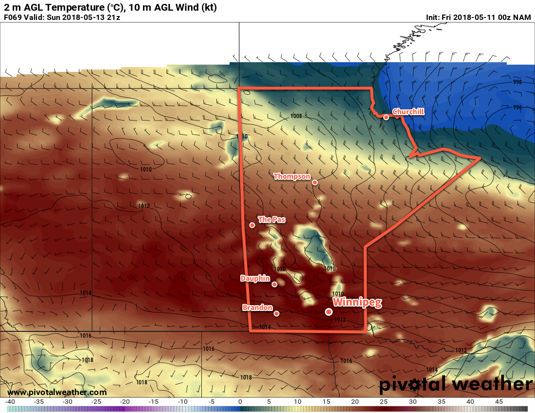
An upper-level ridge building eastwards across the Prairies will bring mainly sunny skies to Winnipeg and the Red River Valley over the next few days. Temperatures will range from seasonably warm – daily highs will be low 20’s both today and Wednesday – to hot with temperatures peaking near 30°C on Tuesday.

RDPS 2m Temperature Forecast valid 21Z Tuesday May 15, 2018
Temperatures will climb toward 30°C across the southern Prairies on Tuesday with breezy west-southwest winds.

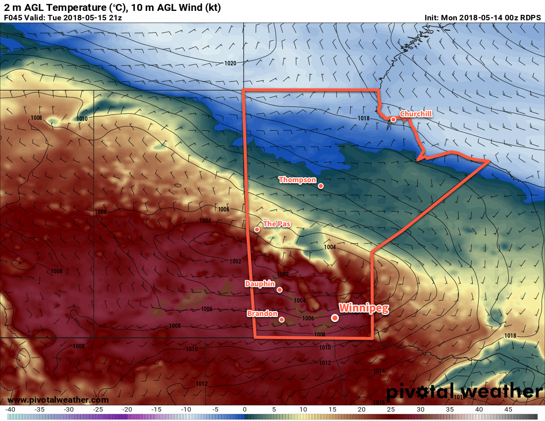
The bone dry conditions will continue with no rain expected through Wednesday. As highlighted in our last forecast, this means that Winnipeg will likely enter into one of the top 5 longest dry spells on record, tying 1882’s fourth place record of 34 days.1 A couple of low pressure systems will roll through the region, but any rain associated with them will likely stay north of Winnipeg.

Winnipeg Jets Whiteout Party!
It will be another great evening for Game 2 of the Western Conference Finals as the Jets take on the Golden Knights at 7:00PM. Temperatures will be around 20°C when the game starts and cool to around 13°C by 11 PM. Winds will be start near 20 km/h and quickly diminish as the evening progresses under clear skies. All in all, fantastic weather for the Whiteout Party that’s not too different from the last one! Lets just hope the Game 2’s outcome is as much of a repeat as the weather!

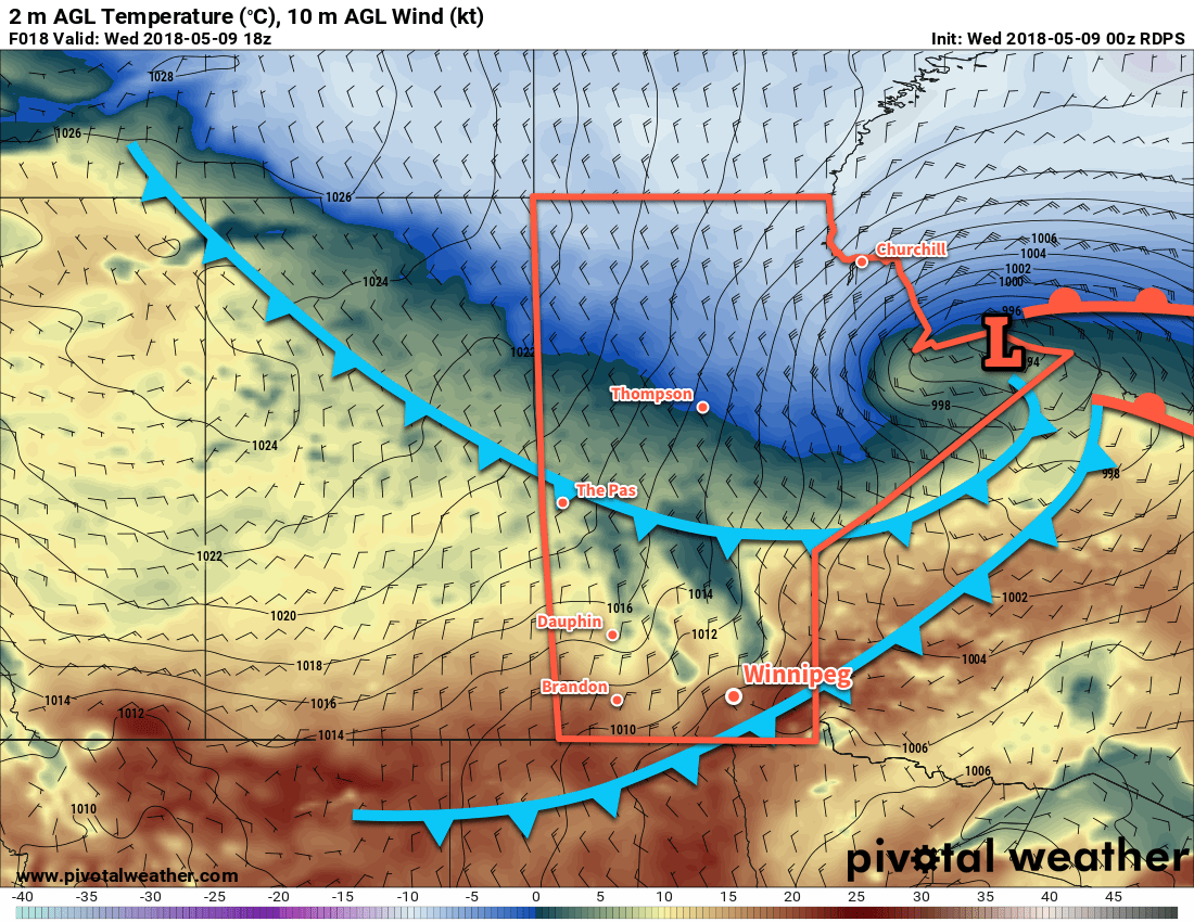
Winds will be noticeable over the coming days. Today will see northerly winds near 30 km/h develop this afternoon. Tuesday will bring breezy south to southwesterly winds of 30 to 40 km/h as a low crosses through the Interlake region. Wednesday will then bring northeasterly winds of 20 to 30 km/h as a low pressure system develops in Montana. The winds should subside each evening.

Long Range Outlook

Beginning Wednesday night, most models show increasingly unsettled weather. On Thursday through Friday, two disturbances will begin producing showers across southeastern Saskatchewan into southern Manitoba. The first is an upper disturbance that will track eastwards from Alberta to Manitoba. The second is a low that will track from the American Central Plains northeastwards into Minnesota.

Unfortunately, it’s difficult to tell where exactly any precipitation that develops may fall. Much of it will be convectively driven, so model-based rainfall forecasts will likely vary wildly over the coming days.

The potential exists for measurable rainfall over a wide area with this system, however there continues to be a possible evolution of these systems where much of the rain misses the Winnipeg region. We’ll be keeping a close eye on it and have updated details mid-week!

Winnipeg’s seasonal daytime high is currently 19°C while the seasonal overnight low is 5°C.

  1. Records sourced via Rob’s Obs.

Dry Weather Continues As Temperature Heat Up

The drought continues in Winnipeg as temperatures begin to climb back toward the upper 20s. But for those with plans to head downtown on Saturday for the Jets game? It’ll be a beautiful evening!

There’s no relief for the drought in sight for Winnipeg. The dry spell the city has seen is now into its 28th day, and will likely enter into the top 5 longest dry spells on record next Wednesday.

Winnipeg will see partly cloudy to mixed skies as cloud cover left over from a disturbance that moved into Saskatchewan yesterday gradually clears out. Temperatures will stay a tad below seasonal with a high near 16°C. Skies will clear overnight as temperatures drop to a low near +4°C.

The weekend will bring sunny skies to Winnipeg with gradually warming temperatures. Saturday should see a high near 21°C and Sunday will be even warmer with a high near 27°C. Both nights should see overnight lows in the low teens.

Winnipeg Jets Whiteout Party!
It will be a beautiful evening for Game 1 of the Western Conference Finals as the Jets take on the Golden Knights 6:00PM Saturday evening. Temperatures will be right around 21°C when the game starts and cool to around 16°C by 10 PM. Winds will be light and skies will be clear; fantastic weather for the Whiteout Party! Lets just hope the outcome of Game 1 is as nice as the weather!

Winds will be relatively light on Friday and Saturday, but a low passing through northern Manitoba will bring west-southwest winds of 30 gusting to 50 km/h to the Red River Valley on Sunday.

NAM 2m Temperature Forecast valid 21Z Sunday May 13, 2018
Temperatures in the Red River Valley will climb into the upper 20s on Sunday afternoon.

Not a drop of rain is forecast to fall over the next 3 days.

Long Range Outlook

Next week will start warm with highs in the upper 20’s or possibly even the low 30’s. Some forecast models bring the potential for some showers to Winnipeg mid-week. Unfortunately, it’s the result of a complex interaction of two systems that converge over southern Manitoba. This makes it so, again, it’s not too hard to see a situation where the Red River Valley escapes any rainfall. Perhaps hold off on placing any bets regarding wet weather next week.

After that disturbance passes, Winnipeg looks to return to near-seasonal temperatures with variable cloudiness.

Winnipeg’s seasonal daytime high is currently 19°C while the seasonal overnight low is 5°C.

Cool, Dry Weather Ahead

Winnipeg will see a break from the heat for the remainder of the week, but the dry conditions continue with no significant rain on the horizon.

A cold front will sweep through Winnipeg today, bringing cooler temperatures to the region that will stick around for the rest of the week. Winnipeg will see a high temperature near 16°C both today and Friday, but Thursday will bring even cooler conditions with a high near 12°C. Overnight lows will sit right near freezing tonight and tomorrow. Friday night should bring slightly warmer temperatures with lows near 4 or 5°C.

Winnipeg will see mixed to cloudy skies this morning and as the cold front passes midday, followed by clearing skies this afternoon. Winds will be quite breezy behind the front as they pick up to around 40 gusting 60 km/h out of the north. The cooler temperatures and northerly wind will bring a chill to the air that will put a bit of a damper on the late-day sunshine. The cold front has a tiny chance of producing scattered showers as it moves through, but they’ll be short lived with little, if any, measurable rainfall.

A cold front will sweep through the Red River Valley midday Monday, ushering in moderate northerly winds

The wind will diminish this evening, leaving clear skies and light northerly winds in Winnipeg for the night and much of Thursday. Cloud cover will begin working back into the region on Thursday afternoon, bringing mostly cloudy skies to Winnipeg on Thursday night.

Winds remain light on Friday, and mixed to mostly cloudy skies look likely. Some clearing will work into the Red River Valley late in the day, resulting in partly cloudy skies on Friday night.

Long Range Outlook

The heat returns on the weekend with temperatures climbing back into the 20’s under sunny skies. It looks as though both Sunday and Monday could bring highs approaching the 30°C mark again.

Much of southern Manitoba is currently considered to be under extreme fire danger, shown in red. (Source: Canadian Wildland Fire Information System)

While often this would be cause to celebrate, the extremely dry conditions will only be getting worse, and the warm weather will bring with it an extreme fire danger.

Unfortunately, little change is on the horizon. There’s a slight chance of some showers next Tuesday, but it’s easy to see an outcome where all the rain remains south of the 49th parallel. Until measurable rain arrives, fire prevention will keep becoming a larger issue as everything continues to dry out.

Winnipeg’s seasonal daytime high is currently 18°C while the seasonal overnight low is 4°C.

India Faced with Intense Heat Wave

A heat wave has taken hold across much of India in the past few weeks and will continue to do so before monsoon season arrives next week.

[map autofit=”1″ disable_scrollwheel=”1″] [pin]Bhubneshwar[/pin] [pin]Andhra Pradesh[/pin] [pin]Rajasthan[/pin] [/map]

A weak ridge aloft has allowed extreme heat to build into the region while tropical dewpoints over 25°C remain in place. With these temperatures and dewpoints combined, several locations in Eastern India, like Bhubneshwar, have seen humidex values above 55°C – signifying heat stroke is probable with any time spent outside. Not only that, but overnight lows stayed well above 30°C for several days in some regions, providing no relief to the residents. Additionaly, dust storms have been taking place across the drought stricken areas in the north. In Rajasthan, a dust storm killed seven people two weeks ago. Heat waves can be crushing to developing countries, such as India, resulting in exponentially more deaths and damages compared to first world countries as residents have limited access to clean drinking water to hydrate themselves, never mind air conditioned houses.

Asphalt was literally melting away on New Delhi roads  due to high temperatures this week. (Source: Rappler)
Asphalt was literally melting away on New Delhi roads due to high temperatures this week. (Source: Rappler)

Over half of the deaths (1,334 deaths) associated with the heatwave came from the Andhra Pradesh province, while the most recent overall death tally reached 1,826 people. This, according to Jeff Masters of Weather Underground,  is the fifth deadliest heat wave in world history since record keeping began and second deadliest to India (deadliest was 1998). Water shortages were the main problem leading to dehydration and heat stroke; to combat this, the country brought in water tankers and aid to over 4,000 towns in the hardest hit areas.

Help might be on the way however. The seasonal rains that India experiences, called monsoonal rains, are advancing northwestward towards the heat-stricken provinces. These will not only bring much needed moisture to the region, but also allow temperatures to drop well below what India has been experiencing past few weeks. The few weeks preceding the monsoonal season typically do bring heat waves and dry weather to India, but some years are harsher and last longer than others.