Stormy Start to An Unsettled Weekend

Friday will bring a severe thunderstorm threat to Winnipeg & the Red River Valley as the first of several bouts of unsettled weather moves through, gradually flushing out the unseasonal heat and humidity and transitioning us towards almost fall-like weather.

Friday
29°C / 18°C
Mainly cloudy; showers and thunderstorms this afternoon

Saturday
24°C / 17°C
Mainly cloudy; slight chance of showers. Evening showers or thunderstorms possible

Sunday
24°C / 11°C
Mainly cloudy; slight chance of drizzle or light rain

Mainly cloudy skies will be over Winnipeg & the Red River Valley today while a low pressure system gather steam and begins to move into the region from North Dakota. Little in the way of weather is expected until the low approaches this afternoon and triggers a substantial amount of convective activity. Showers and thunderstorms are expected to fire up mid-afternoon and track to the northeast. There’s a decent chance that the stormy weather will persist well into the evening before it clears out and moves off to the northeast.

AWM Day 1 Convective Outlook
A slight risk of severe thunderstorms exists over south-central and southeastern Manitoba today.

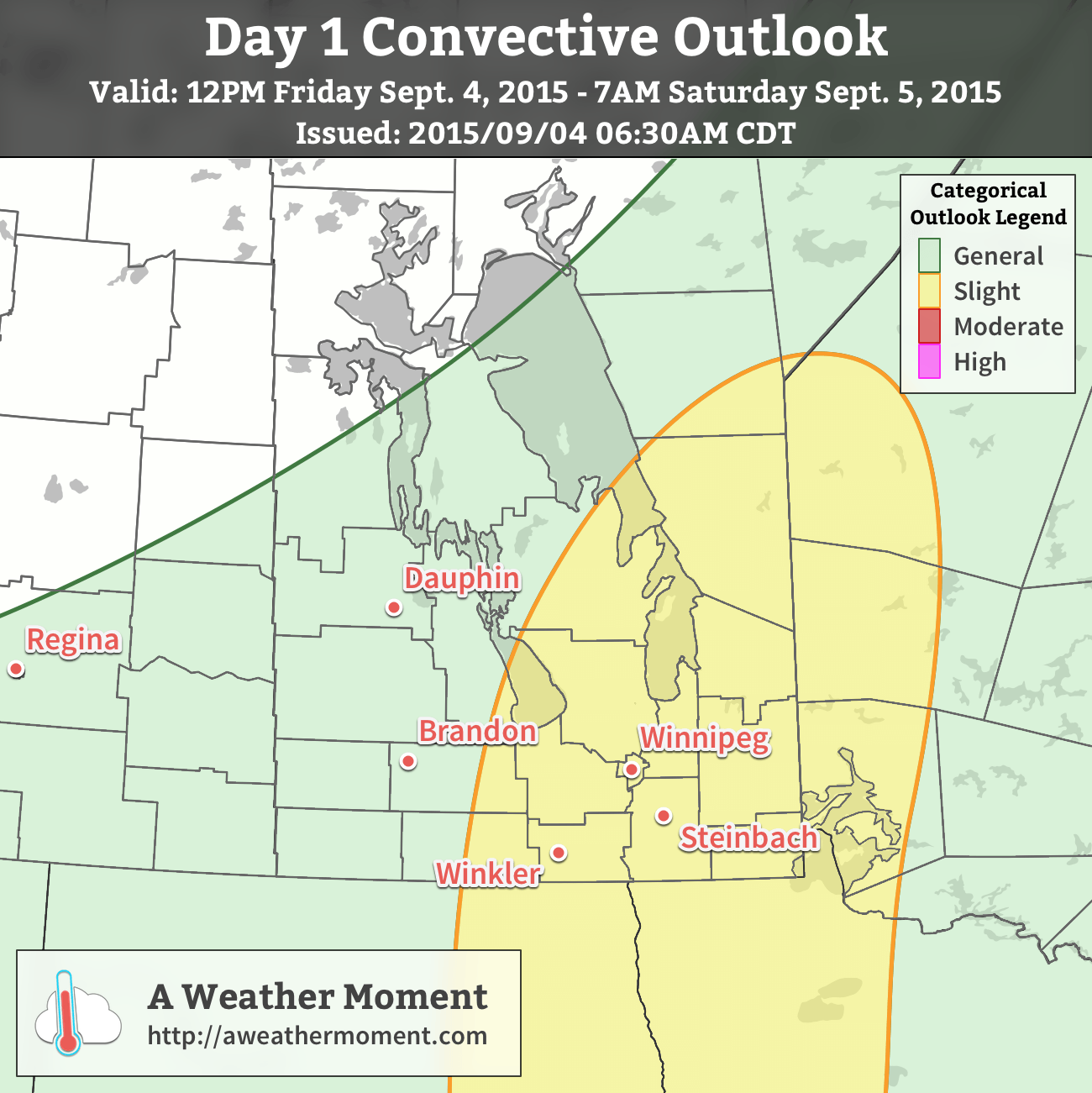
A slight risk for severe thunderstorms will be in place over much of south-central and southeastern Manitoba today. Looking at the MIST basics for thunderstorms:

  • Moisture will be ample with deep boundary layer moisture evident through surface dewpoint values near 22°C thanks to a multi-day build-up of humidity in a southeasterly flow. Strong evidence of the substantial moisture in place is shown by the precipitable water values which are forecast to climb over 50mm through the afternoon.
  • Instability will moderate with MLCAPE values around 2000–2500 J/kg. Much of the instability will be brought through the substantial moisture present since mid-level lapse rates are only expected to be moderate and not excessively steep.
  • Shear will be ample with approximately 25–35kt of 0–6km bulk shear and broadly looping hodographs. This should support the development of organized thunderstorms.
  • Trigger: there will be several triggers converging on the Red River Valley this afternoon including a frontal boundary, approaching low, as well as shortwave aloft. There should be no troubles finding something to trigger thunderstorms.

The primary threats from today’s storms will be heavy rain and large hail. PWAT[1] values are expected to climb over 50mm, which means torrential downpours and flash flooding will be a notable threat with this afternoon’s thunderstorms. Additionally, with such high MLCAPEs and adequate storm structure through the shear profiles, large hail may be an issues, however that would likely be a more isolated threat than the rainfall.

The thunderstorms will gradually push off to the northeast. Total storm rainfalls may exceed 2–4” (50–100mm) in some places, while other areas may end up seeing very little. Be sure to stay alert for any watches or warnings issued by Environment Canada.

Less excitingly, daytime highs will sit around 29°C today (which will feel more like the upper 30’s thanks to the humidity) with winds out of the southeast at 20–30km/h. Expect a low near 18°C.

Cooler, Unsettled Weekend

Both Saturday and Sunday will be cooler days with highs in the mid–20’s. Some uncertainty exists on precisely how things will play out, but in general, a very powerful low pressure system is expected to develop and lift northwards through Saskatchewan through the weekend.

The biggest change, compared to Friday, will be that it seems like the timing for any precipitation will shift from daytime hours towards the evening and overnight hours. Saturday will be mainly cloudy with just a very slight chance of some showers through the daytime hours. As the evening approaches, though, it looks likely that thunderstorms will develop along the western escarpment of the Red River Valley and then progress eastwards across the valley overnight. At this point it looks like the storms will be non-severe, but we’ll keep an eye on them in case the threat increases as we get closer to the event.

The overnight low on Saturday night will be around 17 or 18°C.

Sunday will be another fairly cloudy day with a slight chance of some very light rain or drizzle as easterly winds keep the boundary layer socked in moisture while drier mid-level lift approaches. As the evening approaches, once again some showers or thunderstorms are possible. Expect a low in the low teens on Sunday night.

Next Week’s Weather?

At this point, next week looks much cooler and drier with more fall-like weather in place. Daytime highs through the first half of the week look to be in the 15–20°C range while overnight lows will drop towards the mid-single digits. Little precipitation is expected, and we’ll see more and more sun as the week progresses.


  1. PWAT stands for precipitable water, a measure of how much water is contained in a column of air.  ↩

Elsewhere in Weather News: January 26th, 2013

Oswald Brings Significant Rainfall to Queensland

Southern Australia’s heat wave came to an abrupt end this week thanks to a potent trough that made its way across its southern half. This trough ushered in cooler air and more reasonable highs can be expected with lows in the teens as opposed to the high twenties that they were experiencing last week.

Oswald satellite

Satellite image of Oswald in its early stages, taken on January 21st. (Source: Australia’s BoM)

However, a tropical disturbance, as predicted by the models last week has organised and brought much moisture to Queensland as it made its way south and transitioned into an extratropical storm. Formerly known as tropical storm Oswald, the extratropical storm has dumped over a metre of rain (1000mm) in some areas of Queensland causing for flash flooding concerns. As of Friday evening, 11 flood warnings were in effect (all in Queensland) as well as some wind warnings for the higher elevations and coastal areas. Peak gusts of 115km/h were recorded with Oswald’s passage. It appears as though residents were well prepared as not much damage was reported and only one rescue had to be executed off the coast.

MSLP/rainfall Oswald

MSLP and rainfall for Saturday morning. (Source: Australia`s BoM)

The extratropical storm will get pushed out to sea ahead of the trough early next week giving way to calmer weather for Queensland. Areas of North-East Australia will remain under very warm conditions (over 40°C) through next week, combined with relative humidity below 20%. This could cause some bushfires and Fire Weather Warnings might have to be issued by the Bureau of Meteorology.

Elsewhere in Weather News: July 14th, 2012

Japan Faced With Severe Flooding

Significant flash flooding struck Japan this week due to severe thunderstorms that remained nearly stationary for several hours over the southern island of Kyushu. The stationary boundary collided with warm, moist air from the Pacific igniting the thunderstorms and continuing for nearly 24 hours now, from Thursday afternoon to Friday night causing tremendous amounts of rain to fall over the same areas.

Surface map of Japan

Surface map of Japan with stationary boundary in red and flash flooding region talked about in green box. Effective 1pm Friday, CDT. (Source: Japan Meteorological Agency)

According to the Japan Meteorological Agency, a record of 500+mm (20 inches) fell in Aso and Kumamoto City in less than a 24 hour period overnight Thursday, causing severe mudslides in the area. In all, 15 people have died as a result of the flash floods and mudslides, with 11 still reported missing. Authorities have sent out search teams, where it is safe to do so, to find the missing or buried. As of Friday night, they have found eight survivors buried in the mudslides. The severe mudslides forced people to shovel their way out of houses and to wade through thigh-deep mud to make their way around. Thankfully 68,000 people had been evacuated from the area prior to the storm, avoiding additional casualties. Among the damage, about 22,000 households lost power, train services were shut down, many roads were inaccessible, and rice crops were severely damaged.

Mudslide

First responders searching for survivors where a mudslide destroyed homes. Taken in Minamiaso, Japan. (Source: Reuters)

Kumamoto City

Road covered in mud and cars left over by the flash floods in Kumamoto City. (Source: Jiji Press)

Unfortunately the stationary boundary is not going anywhere any time soon and is forecast to continue to spawn thunderstorms for the next three to five days as the warm, moist air continues to collide with it and the mountains. Another 100+mm is forecast for Saturday in the region once again, with even a slight chance of tornadoes added to the mix. Friday night, heavy rains warnings (including ground-loosening and inundation) and flood warnings were still in effect with an advisory (watch) for severe thunderstorms in the region.

Elsewhere in Weather News: May 5th, 2012

Editor’s Note: We’ve decided to move our weekly Elsewhere in Weather News from Monday’s post to it’s own post on Saturday mornings! We hope this will encourage a little more discussion in the comments about other significant weather and we feel that Matt has been doing a great job; since this “little segment” has become an interesting part of what A Weather Moment is, it’s only right to acknowledge Matt’s efforts and give him his own space! So without further ado, here is this week’s Elsewhere in Weather News, now on Saturdays!


Storms Run Rampant Across the United States

The SPC has had their hands full with severe thunderstorms across the Upper Mississippi Valley and most of the Midwest as the 2012 storm season gets into high gear as we enter the month of May. The strong storms have caused many power outages to several states, including Iowa and Minnesota. In addition to the dangerous gusts brought by these storms, tornadoes were spotted in Iowa on Thursday and in southern Minnesota on Friday. No injuries or deaths were reported.

Across most of the Midwest yesterday, storms ranging between strong to severe rolled through the area resulting in 163 large hail reports and significant flooding in some places. The line of storms crossed Lake Huron into Southern Ontario and dumped a quick 76mm of rain on Orangeville, Ontario –where the average rainfall is usually 75mm for the month of May. This deluge resulted in flash flooding which caused over $1,000,000 in damages to businesses and properties while forcing over a dozen people to be evacuated from their houses.

Storms near Orangeville

Infrared satellite picture taken at 6:45pm showing numerous storms around the time Orangeville got hit by the storm that caused the flash flooding. The colder the cloud top, the stronger the storm. (Source: Environment Canada)

On Friday afternoon an interesting sight could be seen associated with a thunderstorm rolling across Orange City, Iowa: a haboob, also known as a dust storm, was spotted crossing the city limits as the thunderstorm arrived. The haboob is created when a downdraft of a thunderstorm is strong enough to pick up dust and sand ahead of the approaching storm. As the dust gets picked up, a haboob forms and a wall of dust can be seen reaching as high as a couple kilometers into the sky. When the thunderstorm weakens and there are no more downdrafts, the haboob will either just settle or will become a “mud storm” if there is still rain falling that will combine with the dust particles.

Haboob in Orange City

Picture of the haboob entering Orange City (Source: Reed Timmer/TVN)

The best storm dynamics will stay in the High Plains for the beginning of the weekend, slowly shifting south and east as the weekend rolls along.