Elsewhere in Weather News: October 26th, 2014

Vancouver Sees Significant Rain Event

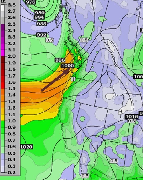
The city of Vancouver has seen its fair share of rainfall this past week, causing flooding problems throughout the metro. What was to blame for this event was an atmospheric river that came onshore the BC Coast, aided by a large upper level trough off the West Coast on Wednesday. Atmospheric rivers are narrow plumes of significant moisture which originate from the subtropics and flow from the southwest onto the shores of the west coast. On Wednesday morning fairly high PWAT[1]
values (>1”), a product of the atmospheric river, nosed into the Vancouver region which set the stage for the heavy rainfall event.

Atmospheric river making its way onto Vancouver island. (Source: Twisterdata)
Atmospheric river (high PWAT values) making its way onto Vancouver island. (Source: Twisterdata)

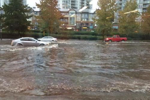
The rainfall started early Wednesday morning for Vancouver, including a thunderstorm that went through the city around 7am dropping heavy rain. With already saturated soil from the rain earlier in the week, flooding problems ensued. Metro Vancouver saw anywhere between 20-35mm, and pockets of locally higher amounts Wednesday. This event comes a day after the same system offshore brought very strong winds (gusts >100km/h) to Vancouver Island as well as downing power lines and snapping trees in metro Vancouver. It was reported that Tuesday night a total of 80,000 people in southern BC were without power at some time.

Flooding in Port Moody, just east of Vancouver, on Wednesday. (Source: Port Moody Fire Rescue)

As this mid-week system departs, it makes way for the next system upcoming system this weekend. This will be yet another fairly strong system to impact the west coast, bringing with it more heavy rains and strong northwest winds. Unfortunately, unsettled weather is expected to last for the Vancouver region into next week.


  1. PWAT stands for precipitable water, a measure of the amount of water contained in a column of air.  ↩

Elsewhere in Weather News: September 20th, 2014

Odile Makes Landfall

The active Eastern Pacific hurricane season that was discussed in the EIWN post a few weeks ago continues to produce – another major hurricane was spun up this week. This time it was hurricane Odile, a category four at its maximum strength, which bottomed out at a pressure of 922mb. This hurricane, however, headed towards the Baja Peninsula and made landfall there as a category three hurricane on Sunday night.

Odile just as it was making landfall on the tip of the Baja Peninsula. (Source: NOAA)

Cabo San Lucas was one of the resorts hardest hit as Odile brought winds of 205km/h upon landfall. As expected with a hurricane of this magnitude, significant damage was done to infrastructure as well as three deaths were reported. About 240,000 residents lost power during the event prompting school closures and flight cancellations; causing major headaches to travellers in the popular tourist destination. Odile eventually weakened into a tropical storm as it made its way further north, interacting with terrain and beginning to get torn apart by shear. Even though Odile had weakened substantially, the storm was not done causing trouble to people in the US Southwest, bringing with it its plume of tropical moisture. Reports of flooded houses and washed out roads were coming out of southern New Mexico and Arizona on Thursday and Friday where as much as 100mm fell in some towns (Sept. average rainfall is around 30-50mm in the region). Streams quickly became rivers and one resident perished as he got swept away by the floodwaters. It’s not all bad news to the US Southwest though, as drought continues to improve in the region.

Damage at the Los Cabos Airport. (Source: Reuters via Dailymail)

There’s already another storm; Polo, churning in the East Pacific but it is not expected to take the same path as Odile did. No other tropical storms are expected to impact the Baja Peninsula in the near future.

Elsewhere in Weather News: September 13th, 2014

Severe Flooding in Northern India and Pakistan

Flooding has been the story for both last weekend and this week as heavy monsoonal rains fell across northern India and Pakistan, having its strongest impact in the Kashmir, Jammu provinces and Jhang district. In this case, the heavy monsoonal rains were caused by very moist air advecting in from the Bay of Bengal due to a low pressure system located in northern India. This moist air was then lifted as it interacted with the rugged terrain of northern India and fell as heavy rain. Satellite estimates show that over 350mm fell in the hardest hit areas in a 7 day period, resulting in rivers overflowing their banks and putting residents at risk.

Satellite image of the low pressure system over northern India; combined with orographic lift, it made for heavy rain in the region. Taken on September 5th. (Source: NASA via Wunderground)

According to news outlets, 5,000 rescues had to be executed in the flooded region as people scrambled to higher ground. When floodwaters will have receded damages will be significant; about 980 villages in the region have seen flooding problems. On Friday night it was reported that 461 people have died due to the flooding with 600 more injured. Some 60,000 residents continue to evacuate to higher ground, not only in concern of flooding waters but also infrastructure being washed out leading to significant transportation problems for food and clean water. In developing countries the residents are typically affected by not only the initial disaster, but also the aftermath of the disaster. This is the case here as water borne diseases are of great concern to officials and will be a true threat to some residents as floodwaters recede. It’s estimated that over one million people have already been affected by this disaster.

In other news several tropical disturbances have formed in the Atlantic, including a tropical storm in the mid-Atlantic. These should be watched in the next few days, however, there is fairly strong shear in the region currently which is causing problems for these storms to develop further.

Elsewhere in Weather News: August 30th, 2014

Montana Sees Unusual August Flooding

The same strong low pressure system that brought 20–40mm to the Red River Valley last weekend brought significant rainfall to parts of central and eastern Montana. These extreme rainfall events in August are uncommon for Montana as strong systems usually stay well north with the polar jet stream and wildfires are typically the concern around this time of the year.

Storm total rainfall for parts of central and eastern Montana (in inches). (Source: NWS Glasgow)

The deep low pressure system brought heavy rain (with a few breaks) to the region between August 21st and the 24th. Combined with abnormally high Precipitable Water values (PWAT) in the region, this made for high rainfall totals throughout the region. Storm total reports between 175mm and 200mm were not uncommon. Glasgow, MT saw around 145mm fall through the event (Aug. 21–24) which is four and a half times their monthly average rainfall for the whole month of August. In comparison to last year, they had less than a quarter of their monthly average rainfall by this time.

Milk River near Glasgow reached major flood stage Monday and Tuesday. (Source: NWS Glasgow)

Many rivers in the regions quickly swelled up and spilled their banks including the Milk River which entered major flood stage near Glasgow on Monday. Mudslides also became a concern in the more mountainous regions. It appears that most of the damage due to the flooding occurred to roads and culverts, however some homes were damaged as well. Thankfully, there have been no reports of injuries. Crews are slowly working to rebuild the washed out roads.

More rain is impacting the region today, but nothing close to the magnitude of what was seen last weekend.