The soggy spring we’re experiencing in Southern Manitoba just doesn’t seem to be letting up. With some areas in Southeast Saskatchewan and Southwestern Manitoba already having seen in excess of 2/3s of what they normally receive through an entire year, everybody, including the ground, is ready for a break from the rain. Unfortunately, it doesn’t look like it’s in the cards. A sunny and warm weekend will change into quite an unsettled pattern for the first half of next week. Read on to find out where and how much rain will fall.

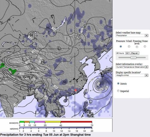
24hr. QPF valid 12Z Monday morning from the 00Z Friday Jun 10 GEMGLB model.
Enjoy the sunshine and warmth today and tomorrow! Plenty of sunshine is in store for us with daytime highs in the low twenties and fairly light winds. Most of Sunday will be pleasant as well, but by evening a new system is going to be pushing into Southwest Manitoba.
An trowal will swing through Southern Manitoba Sunday night through Monday, bringing with it another batch of rain and thunderstorms. By Sunday evening, rain will begin to push into Southwest Manitoba with a chance of thunderstorms developing before midnight. While much concern exists about the more rainfall for SW Manitoba, it looks currently like the greatest threat for heavy rain exists from areas south of Winnipeg and spreading eastward through the Whiteshell.
As the trowal rotates into our area on Sunday, an area of thunderstorms should rapidly develop on Sunday evening in North Dakota near and east of the triple point of the associated wave. For those who don’t know what that is, the triple point is the point where the warm front and the cold front meet. This should develop upscale quite rapidly into a large MCS that will track east northeast and should cross into S. MB overnight. Currently, it appears that Winnipeg would be on the northern edge of the higher amounts, with it likely that areas south of the city could see 20-40mm of rain. Areas elsewhere in Southern Manitoba (including the Southwest corner) that are not impacted by the MCS from North Dakota will see between 10 and 20mm of rain through Monday evening.
This system will then pull northward and rotate into Central Manitoba. Unfortunately, this prolonged period of rain could bring an additional 20-30mm to the absolutely soaked Interlake region, which is battling un-before-seen high lake levels.
Perhaps of even bigger concern is the next system that will barrel into Southern Manitoba on Wednesday evening. While details are sure to change, this has the potential to be the most significant convective system we’ve experienced this year. An extremely intense shortwave will head northeast into North Dakota through the day on Wednesday and initiate a large area of convection by Wednesday evening. This convection will be pulled northward with the shortwave as it slowly becomes captured in an upper low and rests over the western lakes.

12hr QPF valid 12Z Wednesday morning, June 15 from the 00Z Friday June 10 GEMGLB.
Thunderstorms will develop and intensify through an upper trough and pull northward into the upper low, resulting in prolonged, intense precipitation along a fairly narrow band. Positioning will be crucial for this system, but with the potential to be dumping 1.5” – 3” of rain through the RRV into the Interlake, this will be a extremely important system to keep an eye on.
So get out and enjoy the sun! As summer tries to push in next week, the storm track is going to move back into Southern Manitoba and we are likely going to see several impulses move through during the week.