More Dry, Mild Weather Ahead for Winnipeg

Like we mentioned in our forecast earlier this week…it’s steady going as the mild conditions persist through southern Manitoba this weekend.

RDPS 2m Temperature Forecast valid 21Z Saturday February 3, 2024
Above-normal temperatures will be in place over the Prairies for another weekend.

An upper ridge continues to dominate the Prairies, bringing a Spring-like pattern to the region. Mild weather continues across the entire region with daytime highs over 10 °C above seasonal values.

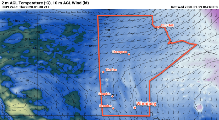
Highs in Winnipeg will continue to reach 2 to 5 °C over the next few days. Breezy southerly winds will develop today, strengthening to 30 gusting 50 km/h, that will begin to ease in the evening. Overnight lows will dip into the -5 to 0 °C range.

With the warm weather, fog may be an issue each night as the melt is caught under a strong inversion.

Skies will start with plenty of sunshine today, but could cloud over this afternoon if an area of low cloud in Minnesota reaches far enough westwards as it pivots northwards into Canada. Heading further into the weekend, skies will trend cloudier as a weak low pressure system begins to track eastwards across the Prairies.

Little precipitation is expected for the area this weekend, but there could be light drizzle or flurries across the region on Sunday as the low moves into the area.

Long Range Outlook

Next week, cloudier conditions will develop for Winnipeg as a low pressure system crosses the province. In its wake, temperatures will cool below freezing but stay well above seasonal values.

Long-range forecast models show indications that a Colorado Low could impact the region by the end of the week. The more reliable long-range models have it more progressive and keep its impacts south and east of Manitoba, but sometimes weather models under-develop the upper troughs associated with these systems and they can end up slower and further west than initially forecast. That said, more moisture wouldn’t be a terrible thing for southern Manitoba at this point.

We hope you can get out and enjoy the pleasant weather this weekend! We’ll see you back here next week.

Today’s seasonal daytime high in Winnipeg is -11 °C while the seasonal overnight low is -21 °C.

RDPS 2m Temperature Forecast valid 21Z Thursday January 30, 2020

Broken Record: Cloudy Conditions Continue

More of the same is on the way for Winnipeg as temperatures gradually climb through the rest of the week.

A stagnant flow over the eastern Prairies will keep skies mostly cloudy in Winnipeg through the next few days. While an odd patch of clearing may be possible – although these small gaps are practically impossible to forecast ahead of time – skies should stay cloudy through a vast majority of the coming days.

A weak disturbance moving through southern Manitoba will spread some light snow across the Red River Valley today. The organized snow will taper off later in the day, but the chance for flurries will continue through Thursday. Temperatures will gradually warm with highs reaching around -2°C on Friday. Lows will follow suit, climbing towards -5°C by Friday night.

The only change the region may see over the coming days is a greater likelihood of mist and fog. While it will be possible from tonight onwards, the chance is higher towards the end of the week.

Long Range Outlook

A change is finally coming to the region this weekend. A well-organized low will track across the northern Prairies, bringing westerly winds across the Prairies and clearing out some of the low-level moisture trapped in the region. Temperatures will stay near-freezing through the weekend, but then a strong cold front will sweep through the region late Sunday. Temperatures will head back towards seasonal values to start next week alongside some much-appreciated sunshine.

Today’s seasonal daytime high in Winnipeg is -11°C while the seasonal overnight low is -22°C.

Mixed Conditions Mark Transition to Cooler Weather

Today will bring a mixed bag of conditions to Winnipeg and area before a cold front sweeps through the region this evening and ushers in cooler air from Northern Manitoba.

We’re off to a misty, drizzle-filled start to the day here in Winnipeg thanks to a large area of stratus cloud that expanded northwards out of the Dakotas overnight. This expansive area of cloud—stretching from southeastern Saskatchewan across southern Manitoba and into northern Ontario—will remain in place until later this morning; by midday, westerly winds will begin building into the region and help to break up the clouds and bring an end to the fog patches and drizzle.

The sun should make an appearance in Winnipeg this afternoon as temperatures head towards a pleasant high of 20°C. The sunshine will be relatively short-lived as a cold slumping southwards out of central Manitoba spreads another batch of cloud southwards.

GDPS 850mb Temperature Forecast valid 00Z Thursday April 21, 2016
A cold front separates above-normal temperatures in southern Manitoba from well below-normal temperatures pushing southwards through northern Manitoba.

When the cold front slides through this evening, there will be a slight chance of an isolated shower or thundershower. This activity is not expected to be particularly widespread and will taper off very quickly once the sun begins to set. Breezy northerly winds of 20-30 km/h will move in behind the front ushering in cooler air that will send Winnipeg’s overnight low to near +2°C.

Thursday will be a pleasant but cool day with just a few clouds and a high near 8°C. Winds will continue to be breezy in the morning at 20-30 km/h, but will gradually taper off through the day. Expect an overnight low near -1°C with increasing cloud.

Friday will bring mainly cloudy skies as a frontal zone sets up across the eastern Prairies. Winds will be light and there will be just a slight chance of some light shower activity. Expect a high near 8°C once again and an overnight low near +1°C.

Winnipeg’s seasonal daytime high is currently 13°C while the seasonal overnight low is 0°C.

Mild Weather Continues

This week will remain mild with temperatures generally on the positive side of zero. However, there will be a chance for precipitation on Tuesday.

Today will see a continuation of Sunday’s warm weather. High temperatures will be in the mid single digits in the Red River Valley, and perhaps a bit higher over the snow-free area to our west. Skies over the Red River Valley will be a mixture of sun and cloud, while conditions over western Manitoba are mainly cloudy. The only wrinkle in today’s forecast is the potential for fog tonight, aided by the additional moisture generated by the snow melt.

A low pressure will pass to our south on Tuesday, bringing rain and snow to southern Manitoba. At this point it looks like precipitation over south-eastern Manitoba will primarily come in the from of rain. The Red River Valley will probably see a mix of rain and snow, while western Manitoba sees primarily snow. Large amounts of rain/snow are not expected, but models hint at the potential for localized bands of moderate precipitation which could bump up totals in some areas. Most areas will probably see 3-6 mm of accumulation, in the form of rain and/or snow.

RDPS MSLP & 3hr. QPF valid Tuesday morning.
A weak Colorado Low will bring precipitation to the Red River Valley on Tuesday.

Wednesday will be a slightly cooler day as a colder air mass surges southward behind Tuesday’s departing low pressure system. High temperatures will be near the freezing mark with breezy north winds.

Long Range

The long range forecast shows no indication of winter returning. Models strongly suggest that most, if not all, of March will be seasonably warm. Enjoy the snow now, it may not last much longer!