This week will remain mild with temperatures generally on the positive side of zero. However, there will be a chance for precipitation on Tuesday.
Today will see a continuation of Sunday’s warm weather. High temperatures will be in the mid single digits in the Red River Valley, and perhaps a bit higher over the snow-free area to our west. Skies over the Red River Valley will be a mixture of sun and cloud, while conditions over western Manitoba are mainly cloudy. The only wrinkle in today’s forecast is the potential for fog tonight, aided by the additional moisture generated by the snow melt.
A low pressure will pass to our south on Tuesday, bringing rain and snow to southern Manitoba. At this point it looks like precipitation over south-eastern Manitoba will primarily come in the from of rain. The Red River Valley will probably see a mix of rain and snow, while western Manitoba sees primarily snow. Large amounts of rain/snow are not expected, but models hint at the potential for localized bands of moderate precipitation which could bump up totals in some areas. Most areas will probably see 3-6 mm of accumulation, in the form of rain and/or snow.
Wednesday will be a slightly cooler day as a colder air mass surges southward behind Tuesday’s departing low pressure system. High temperatures will be near the freezing mark with breezy north winds.
Long Range
The long range forecast shows no indication of winter returning. Models strongly suggest that most, if not all, of March will be seasonably warm. Enjoy the snow now, it may not last much longer!
Will the daytime temps continue to be above 0? I collect maple sap, and it starts flowing when the days are above and the nights below. I have already inserted most of my taps and hung up buckets, after I saw your forecast on Saturday, and woke up to the beautiful weather and snow melting yesterday :).
Tuesday & Wednesday will see temperatures near 0, but after that, it looks like a very nice stretch of daytime highs above 0, possibly persisting for the next 2 weeks. Overnight lows will likely dip below 0, but there are hints that we could see several nights with lows at or just above 0! I wouldn’t be the least bit surprised to see most or all of our snow gone within the next 2 weeks.
That sounds ike a great forcast, thanks :).
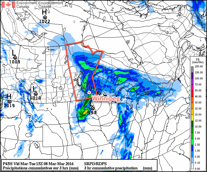
Weather Update for Tuesday’s Colorado Low over Southern Manitoba
As mentioned in our latest blog post
(http://aweathermoment.com/2016/03/07/mild-weather-continues-2), Tuesday
will bring the potential for rain or snow to Winnipeg & the Red River
Valley as a as Colorado Low strengthens tonight and crosses through the
Dakotas towards Lake of the Woods.
This system will have two “phases” that Southern Manitoba will
experience. The first phase will occur tonight as the preliminary area
of synoptic lift pushes northwards over the province as an inverted
trough develops up the Red River Valley from the low center in the
Dakotas. The initial weather that we’ll experience through the Red
River Valley is the rapid development of cloud and the chance for
drizzle, light rain and fog patches. This will spread eastwards into
the Whiteshell as well through the overnight period. No significant
precipitation is expected through our region with most of the organized
activity remaining to our north ahead of the advancing upper-level warm
front.
Mid-level instability is expected to develop overnight as the synoptic
lift intensifies, and there has been some question of the potential for
thunderstorm development. While even here in Winnipeg there will be
some instability that develops overnight, much of the forcing that could
support and sustain elevated convection (such as frontogenetic forcing
and lift associated with the LLJ) will remain to our SE in the Dakotas
and Minnesota. The Sprague region looks to get clipped by these two
forcing features, though, and they may see some weak thunderstorm
activity overnight into the morning. The most likely situation I see at
this point is elevated convection developing through eastern North
Dakota and then spreading northeastwards through Minnesota; some of it
may clip SE Manitoba.
Tomorrow will be the second phase of this system that will see
precipitation develop along a cold front that surges southwards behind
the low pressure center. This will likely result in a relatively narrow
band of rain and/or snow that develops through central North Dakota and
spreads northeastwards through the Red River Valley and into the
Whiteshell. The exact placement of this will be fairly important as the
northwestern edge of the precipitation will likely be quite sharp as
moisture butts up against the low’s deformation zone.
At this point, it looks like much of the precipitation will remain to
the south and east of Winnipeg, however it’s close enough that we may
see some or [if the system ends up a bit further northwest] all of it.
It’s expected to be convective in nature, which means it will likely be
fairly heavy at times. If any falls as snow, it’s likely that
visibilities would be severely restricted in heavy snowfall and the
change could be quite abrupt. Along with the precipitation, strong
northwesterly winds up to 50 gusting 70km/h will move into the Red River
Valley.
The precipitation will taper off through midday & the afternoon as it
pushes off into Ontario.
After a brief cool-down with temperatures near- to slightly
above-seasonal, significantly above-normal temperatures are expected to
return to Manitoba for much of the coming 2 weeks.