Warming up This Week in Winnipeg

It will be a cloudy week in Winnipeg as temperatures climb back towards the freezing mark.

RDPS 2m Temperature Forecast valid 21Z Wednesday January 24, 2024
Warmer temperatures will spread across the southern Prairies this week.

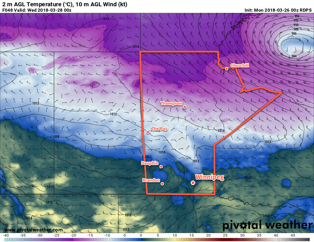
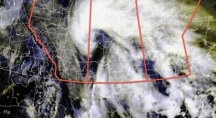
With the Polar Vortex retreating into the High Arctic, a zonal flow will develop across the Prairies this week. Mild Pacific air will spread across the region, sending daytime highs climbing back to near- or above-freezing values. Like many warm pushes deep in winter, this warmer weather will be accompanied by plenty of cloud cover.

Today will be the transition day towards the warmer conditions in the Red River Valley. Southerly winds will strengthen through the day as a ridge of high pressure shifts to the east. By the evening, temperatures will climb to around -5 °C with winds up to 30 gusting 50 km/h. There may be areas of blowing snow in the open valley, but warmer temperatures and lighter winds than Saturday should make it less of a hazard compared to what the region saw on Saturday.

Skies will stay cloudy with a chance of light snow or freezing drizzle tonight with temperatures hovering around -5 °C and southerly winds continuing. The risk of freezing drizzle could continue into the morning.

On Wednesday, conditions will stay steady until a trough moves into the region midday. Winds will ease as it moves in and temperatures will warm close to the freezing mark in the afternoon. Temperatures will dip back down to around -5 °C on Wednesday night with a chance of light snow.

The tail end of the work week will offer benign weather: mainly cloudy skies, daytime highs near -2 °C, and overnight lows near -5 °C on Thursday night and near -10 °C on Friday night. No notable precipitation look likely for either day.

Long Range Outlook

Heading into the weekend, the mild conditions will continue with highs in the -5 to 0 °C range and light southerly winds. The clouds may break up more, though, allowing glimpses of sunshine both Saturday and Sunday.

Heading into next week, the mild weather will continue with a chance that daytime highs could climb above freezing. As a bonus, it looks like more sunshine is possible than the region will see this week.

Forecasts show no notable snowfall events through next week.

Today’s seasonal daytime high in Winnipeg is -13 °C while the seasonal overnight low is -23 °C.

Seasonal Conditions To Be Ousted Mid-Week By Arctic Cold Front

Winnipeg will see a couple more days of near-seasonal temperatures before a cold front swings through on Wednesday. Behind the passage of the cold front, a cooler Arctic air mass will settle over the region, bringing March to a close with significantly cooler-than-seasonal temperatures.

Mostly cloudy skies will continue in Winnipeg today with light winds and a high near +2°C. Temperatures will down to a low near -3°C tonight under mostly cloudy skies as well. A low pressure system moving through northern Manitoba tonight will bring westerly winds into the Red River Valley for Tuesday, which will help clear out the cloud cover and bring some sunshine back to the region. Temperatures should reach a high near +4 or +5°C, but with fairly warm temperatures aloft in advance of the next low pressure system, isolated areas with less snow cover could see temperatures as warm as +7 or +8°C.

RDPS 2m Temperature valid 00Z Wednesday March 28, 2018
Temperatures will vary between 0°C and +8°C across southern Manitoba on Tuesday

As the next low pressure system pushes into southern Manitoba on Tuesday night, more cloud will build back into the region with southerly winds of 15 to 25 km/h. There may be a passing shower or flurry on Tuesday evening, then temperatures will head towards a low near -1°C. The centre of the low pressure system will move through the Red River Vally on Tuesday night, bringing with it what looks like a fair chance of drizzle or freezing drizzle, depending on exactly what the temperature is at the time.

Forecast sounding for CWYG valid 09Z Wednesday March 28, 2018
Drizzle will be a distinct possibility on Tuesday night with a risk of freezing drizzle as temperatures drop below freezing Wednesday early Wednesday morning

Wednesday will see any remaining drizzle dissipate in the morning as a cold front slumps southwards. Temperatures will drop in the wake of the front to near -3°C by the evening as northwesterly winds of 30 to 40 km/h usher in a colder air mass. The cloud cover should break up on Wednesday night as temperatures drop to a low near -12°C.

Long Range Outlook

The remainder of March into the start of April will bring well below-seasonal temperatures to the region.

NAEFS 8-14 Day Temperature Anomaly Forecast — Valid April 2 to 9, 2018

The remainder of the week into the weekend is looking unseasonably cold with daytime highs in the mid-minus to low-minus single digits and overnight lows in the -15 to -20°C range. The cold will linger at least through the beginning of next week.

Winnipeg’s seasonal daytime high is currently 3°C while the seasonal overnight low is -8°C.

Snow Tapering Off As Winnipeg Digs Out

Snow will gradually taper off today as Winnipeg digs out of the biggest snow storm of the 2017/18 winter season.

The long-advertised winter storm has finally moved into the Red River Valley, bringing a variety of winter weather with it. Everything started off yesterday evening as rain and ice pellets moved into Manitoba from North Dakota. As the precipitation intensified, the rain switched over to heavy snow. In some places, notably near Letellier and west of Winnipeg, people got to experience the rare1 phenomenon known as thundersnow. Heavy snow set up along a southeast to northwest band that remained stationary for much of the night. Winnipeg found itself right under that band, and so far has seen as much as 15 to 20 cm of snow, with snow still falling in some parts of the city.

This storm has had significant impact on southern Manitoba. Through Sunday evening, many area highways began to close as the snow piled up and conditions became quite treacherous. As of 6:15 this morning, most major highways still remain closed. Additionally, the wet, heavy snow has resulted in power bumps or outages throughout Winnipeg and the Red River Valley. Manitoba Hydro’s power outage map shows a rather extensive area where the overnight snow has impacted the power grid.

XWL Base Reflectivity RADAR Imagery valid 6:00 AM CST
Woodlands RADAR shows the main band of snow running northwest-southeast with Winnipeg right on the southern edge.

Periods of snow will continue today as it streams northwestwards through the region. At times where Winnipeg may find itself outside the bands of snow moving through, there will be a slight chance of freezing drizzle. In Winnipeg, the snow should taper off by mid-to-late afternoon as drier air begins moving westwards from Ontario. The snow will continue over the western Red River Valley well into the evening, so travellers will still need to give themselves time and drive carefully if heading west once the highways re-open.

Temperatures will continue to be mild today with a high near 0°C. Winds will continue out of the east around 30 gusting to 50 km/h for the rest of the day. The chance for snow will taper off this evening, as will the winds. The clouds will begin to break up sometime after midnight as temperatures head to a low near -12°C.

Tuesday will bring mixed skies with some gradual clearing towards sunnier conditions in the afternoon. Temperatures will be near-seasonal with a high near -5°C. The winds will be lighter too at about 15 km/h out of the northeast. More clouds will move in overnight as the inverted trough that has been anchored near the Saskatchewan/Manitoba border begins shifting eastwards. Expect a low near -14°C on Tuesday night.

Wednesday will bring the inverted trough back through Winnipeg, bringing mostly cloudy skies and a chance of flurries as it moves through. Temperatures will remain similar to Tuesday with a high near -5°C and low overnight near -13°C. Winds will be light as the trough moves through.

Long Range Outlook

The remainder of the work week will bring variable cloudiness with temperatures climbing back towards 0°C for the weekend. A disturbance moving through at the end of the week may bring another batch of snow to Winnipeg. Forecasts currently show the possibility of 2-5 cm Friday night into Saturday morning. After that moves through, the weather looks fairly quiet with mild temperatures.

Dig out, enjoy the winter wonderland, and get ready for slush and puddles by the end of the week!

Winnipeg’s seasonal daytime high is currently -4°C while the seasonal overnight low is -14°C.

  1. Particularly rare on the Canadian Prairies!

Cooler Temperatures Settle Back Into Southern Manitoba

Cooler temperatures are moving back into the region today behind a cold front that passed through overnight. This cooler weather will persist for several days as an upper-level trough builds over the Prairies, driving the jet stream southwards.

Winter will gradually slump back into Winnipeg as cooler weather slowly pushes southwards through the Prairies, although temperatures will be moderated by an extensive area of low-level clouds that will likely take their time in breaking up.

Today will be the warmest day of the next few with temperatures topping out near 0°C, although a northerly wind at around 20 km/h will be tapping into cooler air to the north. Skies will remain cloudy, though, and a few remaining morning flurries will exit the region early, leaving behind a slight chance for some freezing drizzle. The chance for freezing drizzle will continue overnight as temperatures drop to a low near -8°C.

A cooler air mass will slump southwards over the next few days.

Thursday will continue with fairly cloudy skies; there’s some uncertainty as to how much clearing will manage to occur through the day but in general, expect skies on the cloudier side through the day. Temperatures will climb to a high near -4°C with light northerly winds continuing. Skies may clear a bit in the afternoon, but I’m leaning towards cloudier conditions. We’ll have to see how/if the low cloud begins breaking up over the northern Prairies today as to how much clearing we may see on Thursday. Temperatures will drop to around -11°C on Thursday night with mixed skies.

Friday will bring partly cloudy skies, relatively light winds and a high near -7°C. Not much to say about it! Expect a low near -16°C on Friday night with partly cloudy skies.1

Long Range

Temperatures will continue at near-seasonal values with not too much in the way of snow. Some guidance hints at a system that would bring 2-5 cm of snow to the region on Sunday, but there’s still disagreement on that. After that, it appears that there may be another chance for snow mid-week next week. All in all, though, fairly quiet weather ahead!

Winnipeg’s seasonal daytime high is currently -6°C while the seasonal overnight low is -17°C.


  1. While -16°C is our best bet at the moment, guidance suggests a low somewhere between -14 and -20°C.