India Faced with Intense Heat Wave

A heat wave has taken hold across much of India in the past few weeks and will continue to do so before monsoon season arrives next week.

[map autofit=”1″ disable_scrollwheel=”1″] [pin]Bhubneshwar[/pin] [pin]Andhra Pradesh[/pin] [pin]Rajasthan[/pin] [/map]

A weak ridge aloft has allowed extreme heat to build into the region while tropical dewpoints over 25°C remain in place. With these temperatures and dewpoints combined, several locations in Eastern India, like Bhubneshwar, have seen humidex values above 55°C – signifying heat stroke is probable with any time spent outside. Not only that, but overnight lows stayed well above 30°C for several days in some regions, providing no relief to the residents. Additionaly, dust storms have been taking place across the drought stricken areas in the north. In Rajasthan, a dust storm killed seven people two weeks ago. Heat waves can be crushing to developing countries, such as India, resulting in exponentially more deaths and damages compared to first world countries as residents have limited access to clean drinking water to hydrate themselves, never mind air conditioned houses.
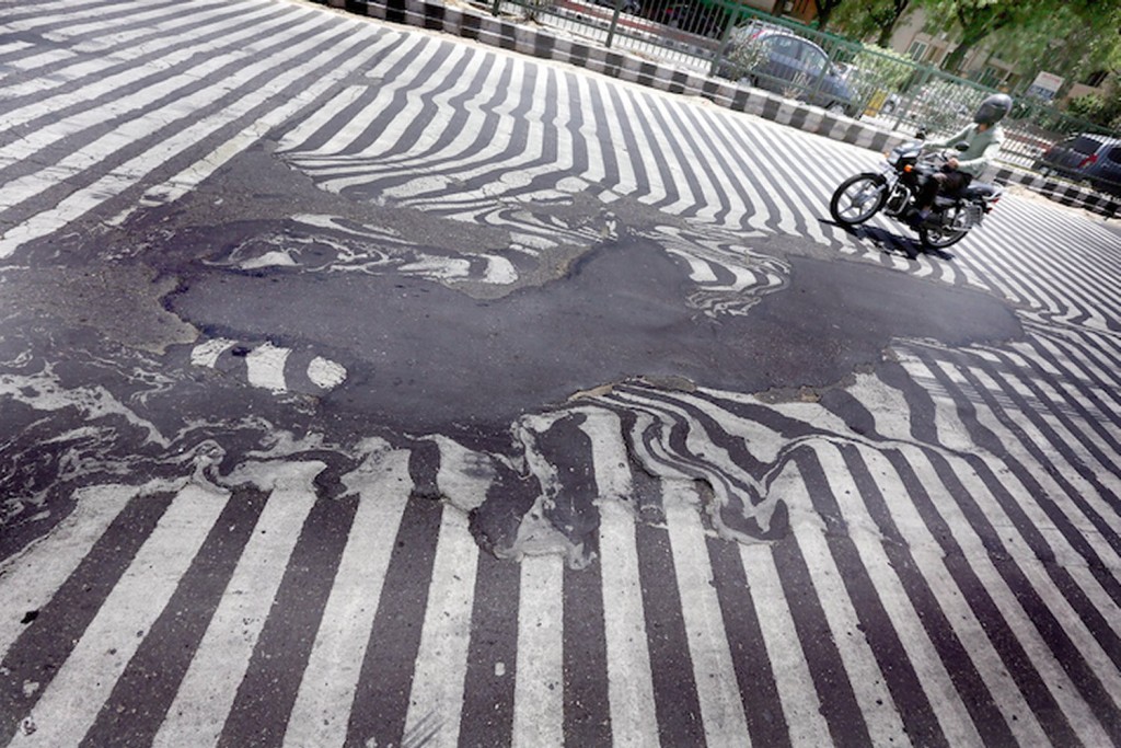
Asphalt was literally melting away on New Delhi roads  due to high temperatures this week. (Source: Rappler)
Asphalt was literally melting away on New Delhi roads due to high temperatures this week. (Source: Rappler)

Over half of the deaths (1,334 deaths) associated with the heatwave came from the Andhra Pradesh province, while the most recent overall death tally reached 1,826 people. This, according to Jeff Masters of Weather Underground,  is the fifth deadliest heat wave in world history since record keeping began and second deadliest to India (deadliest was 1998). Water shortages were the main problem leading to dehydration and heat stroke; to combat this, the country brought in water tankers and aid to over 4,000 towns in the hardest hit areas.

Help might be on the way however. The seasonal rains that India experiences, called monsoonal rains, are advancing northwestward towards the heat-stricken provinces. These will not only bring much needed moisture to the region, but also allow temperatures to drop well below what India has been experiencing past few weeks. The few weeks preceding the monsoonal season typically do bring heat waves and dry weather to India, but some years are harsher and last longer than others.

Elsewhere in Weather News: January 11th, 2014

Cyclone Ian Hits Tonga

This year’s first strong cyclone has spun up in the Southwest Pacific of the Southern Hemisphere. The cyclone – cyclone Ian, formed to the southwest of the Samoan islands and quickly strengthened under prime conditions for intensification. Yesterday the strongest part of Ian clipped the islands of Tonga, as a category four bearing winds around 225km/h and an estimated central pressure near 950mb. All kinds of hazards are associated with a cyclone of this strength: landslides, storm surges and flooding. These risks are enhanced because this cyclone is slow moving. Communications had been cut off from the northern islands on Friday night, where a state of emergency had been issued, therefore the scale of damage to the island remains unknown there. The island of Hunga had reported damage to homes that had their roofs blown off. Tonga’s capital, which is about 100km further south than the northern islands, did not take a direct hit and only minor damage/flooding has been reported there.


A small, but compact cyclone Ian can be seen on IR satellite passing over Tonga on Friday evening. (Source: CIMSS)

The cyclone is expected to continue moving southeast into the south Pacific where it will die off due to cold sea surface temperatures; unfavorable for development.

Australia Baking Under Intense Heat

In other news, Australia is experiencing an intense heat wave which broke numerous daily records as well as a few all-time records such as the new all-time high of 48°C reached at Narrabri on January 3rd. The country has been plagued with heat waves the past few years, including last year which was Australia’s warmest year on record since records started.

Elsewhere in Weather News: January 20th, 2013

Intense Heat Wave Continues in Australia

A significant heat wave has remained in place for most of Australia’s southern half, this past week. The large ridge of high pressure has kept about 70-80% of Australia under extreme high temperatures (over 40°C) and in turn has created dangerous conditions in which bushfires can occur. Total burn bans were in place for a few communities in the southern half of Australia and firefighters are on high alert. As of Friday there were 142 bushfires burning in New South Wales alone and 29 of them were 0% contained.

Temperature map

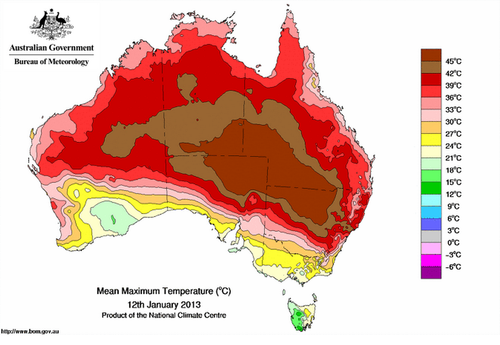
Map of Australia’s extreme temperatures on January 12th, 2013. (Source: Australia’s BOM)

Residents of Tasmania have been experiencing similar weather conditions this New Year, contributing to a massive brushfire that had been raging through a large area of its south-eastern peninsula two weeks ago. Here, 1,000 people had to be rescued by boat from their homes. The damage in that area has not yet been tallied, but at least 20 houses, including a school, has burned down to the ground and at least one person is confirmed dead.

On Friday, January 4th, the village of Wudinna, located on Australia’s southern coast, reached extreme temperatures of 48.2°C, and various other cities broke their daily temperature records as well. Adelaide recorded all-time January high temperatures on the same day as the mercury rose to 44.1°C. Even more impressively, on January 12th Moomba (South Australia) managed to reach a temperature of 49.6°C – Australia’s hottest temperature in 15 years. The average temperature for Southern Australia ranges between 25°C and 35°C in January, and a little cooler for areas along the coast. This past week, Australia’s Bureau of Meteorology even had to go to the extreme by changing the temperature scale on their maps because temperatures constantly exceeded the scale during this intense heat wave.

Trough

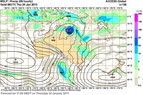
Potential through coming through which would help cool down the temperatures late next week. Also to note a possible tropical disturbance on Australia’s north side. (Source: Australia’s BOM)

Although it is not uncommon to see heat waves affecting specific areas of Australia, to see between 70 and 80% of Australia experiencing a significant heat wave such as this one, is not a common sight. Significant heat will persist into next week before a large trough moves into the region and brings an end to the sweltering heat by next Friday. Interestingly enough, models are also showing a tropical cyclone forming off the Australia’s North Coast around the same time that the heat is predicted to come to an end.

Hot Weather Continues

More warm to hot weather is expected for this week. Our hot spell continues…

The sun

You’ll be seeing a lot of this again this week.

High temperatures through the first few days of the week are expected to be in the mid to upper twenties in Southern Manitoba. No irriguous weather is in the forecast for this period, save for perhaps some rain this morning from a passing thunderstorm complex and a chance for some more showers late this afternoon and through the evening as a bit of cooler air filters southwards on the back-side of the low exiting the province today.

As we move into late week models hint at the potential for another heat wave. The generally accepted definition of a heat wave in North America is three or more consecutive days with high temperatures of 32C or greater (90F or greater). Temperatures of this magnitude may be possible from Thursday through Saturday of this week. In addition, dew points are expected to rise through the latter half of this week, which when combined with the hot temperatures will produce humidex values in the low-to-mid 40s! Since this forecast extends fairly fair into the future weather-wise, it may change somewhat as the week progresses.

As has been the case for much of the last month, long range modelling shows no end in sight to our hot weather. It looks like July should end just as it started – HOT!