Scorching Summer Weather Sizzles Southern Manitoba

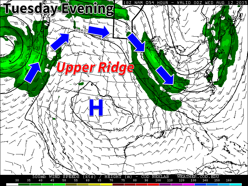
Temperatures will soar into the low 30’s over the coming days as a broad upper-level ridge continues to build across the Canadian Prairies, bringing with it some of the warmest temperatures of the year. Alongside the heat will come several bouts of humidity; at times over the coming days, humidex values – a “feels like” temperature that combines the effects of heat and humidity – will approach or exceed 40, making for exceptionally sweltering weather. In addition to the heat and humidity, today will bring a risk of severe thunderstorms…if they’re able to develop this afternoon.

Wednesday: Hot, Humid & Significant Thunderstorm Risk

Today will be a scorching hot day that will be made oppressively hot by the increasing humidity through the day. Temperatures will soar quite quickly today with the mercury reaching around 30°C by lunch time and then climbing a few more degrees above that this afternoon. All the while, the dew point will climb to the 19–20°C mark, resulting in humidex values in the 37–41 range for much of the day.

The biggest weather story for today, though, is the thunderstorm potential. First, here’s our outlook for today, but the discussion is important, so don’t skip over the rest!

AWM Day 1 Convective Outlook for August 12, 2015

A slight risk of severe thunderstorms exist across the Red River Valley, the Interlake region and eastwards to the Ontario border. Any storms that manage to develop today will have the potential to become very potent storms capable of all types of severe weather, including tornadoes, however there remains a single big question: will there be any storms?

As always, lets take a look at the basic MIST principles of thunderstorm forecasting:

  • Moisture: Ample moisture will be in place as surface dew point values climb to 20°C. 30mb mixed layer dew points are also expected to be in the high teens, which will make for ample fuel availability in convection.
  • Instability: Instability is strong but conditional. Given the high moisture values, MLCAPEs will sit in the 2000–2500 J/kg range while SBCAPE values may exceed 3000 J/kg. The crux is, however, the capping inversion. Strong insolation will chip away at the cap through the day, however 30–50 J/kg of inhibition will likely remain.[1] The big question is, will the combination of surface trough and lake breeze interactions provide enough lift to break the cap? If any storms do manage to initiate, it’s all clear for explosive growth in a strongly unstable environment.
  • Shear: Shear looks fantastic for the development of strong, sustained supercell thunderstorms. 0–6km bulk shear values are expected to be in the 30–35 kt range while hodographs show excellent curvature. No questions exist about how favourable the shear is for supercell thunderstorm development.
  • Trigger: As mentioned above, two triggers will be in place today. The first is a trough line pushing through the Red River Valley & Interlake this afternoon. The second will be various surface boundaries developed through differential heating on escarpments (RRV, Gunton Bedrock) or lake breezes. It’s only slightly likely than any one of these features would be able to provide enough lift to trigger a thunderstorm, however if two or more of these features interact, it could trigger thunderstorm development. The trigger is the biggest uncertainty with today’s thunderstorm potential.

All these factors together combine to give a slight risk of severe thunderstorms across a wide region of Southern Manitoba. Despite the “lower” threat classification, all types of severe weather – flooding rains, large and damaging hail, severe wind gusts, tornadoes – are possible in thunderstorms in the Red River Valley today. The slight risk is given not for thunderstorm intensity – any thunderstorms that develop today could be very, very strong – but rather for the uncertainty associated with if they’ll even occur and expected isolated nature of the storms.[2]

On tornado potential: Today brings with it a non-zero tornado threat, particularly for areas in the northern half of the Red River Valley and southern sections of the Interlake region. Hodograph curvatures are very impressive, and when storm-relative values are taken into account, helicities will be quite high in any thunderstorms that manage to develop. Cloud bases will be fairly high, but high dew points should help diminish significant evaporative cooling below the cloud base. Numerous parameters show favourable environments for thunderstorms capable of producing tornadoes as well. It’s impossible to forecast a tornado this far in advance, but if you live in the slight risk area, it would probably be wise to keep up to date on any watches/warnings issued by Environment Canada.

Temperatures will dip to around 19°C tonight with slightly less humid conditions.

Thursday: A Brief “Cool Down”

Marginally cooler air works into Southern Manitoba behind Wednesday’s trough line which will be reflected in daytime highs a whopping 1–3°C cooler, but still likely at 29–30°C or a touch warmer. Perhaps the bigger difference will be more tolerable humidity levels as dew point values drop into the low teens by the end of the day. Skies will be mainly sunny with relatively light northwesterlies as a ridge of high pressure builds in.

Winds shift southerly in the evening as the Red River Valley moves onto the back-side of the surface ridge and warmer air begins to push in again. Expect a low near 16°C.

Friday: Don’t Worry, It’s A Dry Heat

The heat is back on Friday with daytime highs climbing back to around 33–34°C. It won’t feel as hot as Wednesday, however, thanks to significantly lower dewpoints in the low- to mid-teens. While we’re not talking Arizona desert heat, it’ll be far more comfortable than the 20°C dew points earlier in the week.

Heading into Friday night, deep-layer moisture transport ramps up and will begin bringing significant amounts of moisture into the region aloft. This, combined with warmer air moving in, will lead to a fairly balmy night with lows near the 20°C mark.

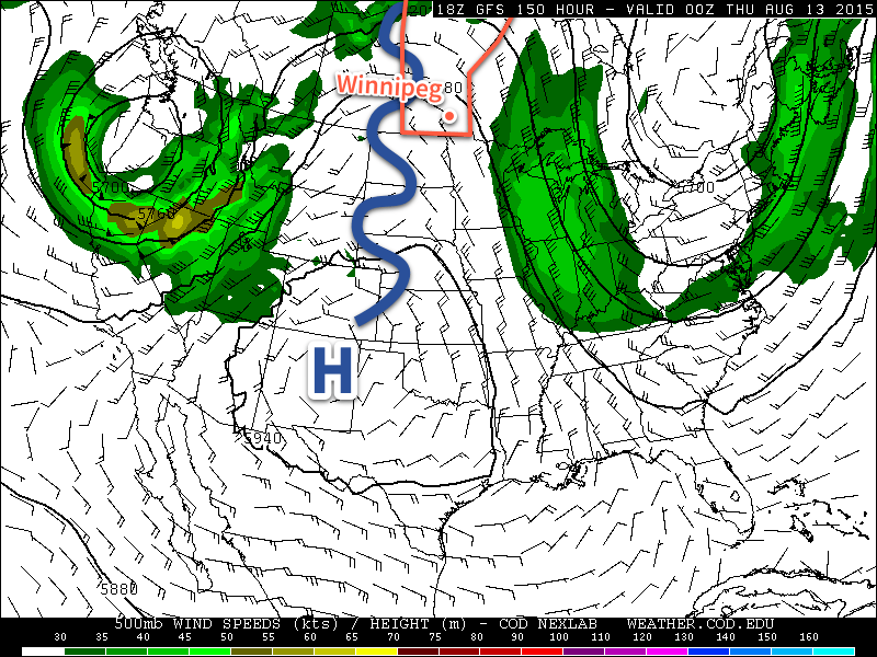
Long Range: Severe Storm Threat Returns on Saturday

It looks like a threat of severe thunderstorms returns to Winnipeg & the Red River Valley on Saturday. Very humid conditions with highs in the upper 20’s will clash with a cold front moving in from the west. Showers and thunderstorms are probable with this front, and with significant energy and shear in the region, it’s entirely possible for severe thunderstorms to develop. It will all depend on the exact strength & timing of the cold front, so we’ll take a closer look at that on Friday when the event is closer.

Sunday will be a comparatively cold day with partly cloudy skies, a bit of a breeze and highs in the low 20’s.


  1. Many studies show that some of the strongest supercell thunderstorms form in environments with between 25–50 J/kg of inhibition.  ↩
  2. At this point, we’re not expecting a huge line of thunderstorms to roll across the Red River Valley; rather it seems probable that there would be just one or two very strong storms.  ↩

Summer Heat Wave Building In

A summer heat wave is on the way as a strong upper ridge builds over the Prairies. Winnipeg will likely see 30°C at least once by mid-week.

Monday

Today will feature increasingly cloudiness through the day as convective clouds develop with daytime heating. We may see a few showers or thunderstorms develop as these convective clouds grow, but any storms will be non-severe. Other than the chance of a shower, it will be a pleasant day with highs in the mid twenties and light northerly winds.

Tuesday

Tuesday will be one of the warmest days we’ve seen in a awhile as high temperatures climb up to the 30C mark in much of southern Manitoba. Skies will be mainly sunny and winds will be breezy from the south. It appears that the humidity will increase somewhat with the push of warmer air, but not too oppressive levels.

An upper ridge over western North America will bring warm weather to southern Manitoba this week

Wednesday

Wednesday should be the warmest day of the week with high temperatures climbing into the low thirties. Some weather models even suggest we may reach the mid thirties, but that remains to be seen. Humidity levels should edge up further on Wednesday, to uncomfortable levels. Humidex values will likely be near 40 in most areas by late afternoon. This higher humidity will also help to create a risk of thunderstorms on Wednesday. At this point it appears severe storms will be possible, but we’ll provide another update as the risk gets closer.

Long Range

The long range forecast suggests we’ll continue to see frequent periods of hot weather through mid August. However, it doesn’t look like the hot weather will be in place continuously, with frequent surges of cooler air breaking up warmer periods. The long range forecast also shows a fairly active storm track through our region, so there will likely be a fairly frequent risk of thunderstorms and precipitation over the next while.

Severe Thunderstorm Threat Marks Transition to Summer Heat Wave

A threat of severe thunderstorms will come to Southern Manitoba today as a trough of low pressure pushes across the region, tapping into very muggy air near the surface. The passage of this system will mark the beginning of a transition towards a summer heat wave as a potent upper ridge begins building over North America.

Friday: Severe Thunderstorm Threat

This morning’s cloud and drizzle will break up through the morning as our winds finally begin swinging around to the west/southwest, finally allowing some sun to begin poking through and allowing us to start climbing towards our daytime high near 25 or 26°C. As we move towards the afternoon, however, a trough of low pressure will begin pushing into the Red River Valley from the west, bringing with it the threat for severe thunderstorms.

Taking a look at the basic MIST principle for today’s convective potential:

  • Moisture: Moderate moisture will be in place today with surface dewpoints near 18°C and mixed layer dewpoints around 16°C.
  • Instability: As the trough swings into the region, mid-level lapse rates will steepen significantly alongside the erosion of the capping inversion thanks to daytime heating. By mid-afternoon, MLCAPE values near 2000 J/kg will develop with little to no capping inversion along the trough line.
  • Shear: Slightly backed surface winds ahead of the trough line coupled with approximately 25kt of 0–6km bulk shear will be sufficient to provide organization to any thunderstorms that develop.
  • Trigger: This is the most questionable aspect. Models differ on the strength of the trough line as it swings through; while some show little strength to it resulting in a lack of convergence and no convection, others show a stronger trough which would be sufficient to focus the energy and produce more substantial thunderstorm activity.
AWM Convective Outlook valid 12PM Friday August 7, 2015 to 7AM Saturday August 8, 2015

As a result, a slight risk of severe thunderstorms is warranted for much of Southern Manitoba. Any storms that develop will likely initiate as single-cell or supercell thunderstorms before growing upscale fairly quickly into linear convective elements. The primary threat with any storms that develop today will be strong winds and large hail, however rainfall rates may pose significant impact in storms despite accumulations likely not hitting any severe criteria.

Thunderstorms will move off towards the east through the evening, leaving behind clearing skies and a pleasant overnight low near 15°C.

Beautiful Weekend Ahead

There isn’t much to say about the coming weekend other than it will be quite nice. Daytime highs on both Saturday & Sunday will be near the mid–20’s with overnight lows in the mid-teens. Winds will be relatively light out of the northwest on Saturday and fairly calm on Sunday. There will be a bit of cloud cover left over on Saturday while Sunday will be mainly sunny.

Heat Wave Builds In Next Week

Next week will see very warm weather return to Southern Manitoba as a potent upper-level ridge builds across much of North America.

GFS 500mb Height & Wind Forecast valid 00Z Thursday August 13, 2015
The GFS 500mb Height & Wind Forecast valid 00Z Thursday August 13, 2015 shows a significant upper-level ridge over much of North America.

As the upper ridge builds, a deep southerly flow will develop over the eastern Prairies, bringing significantly warmer air into the region. With 850mb temperatures forecast to reach 20°C or warmer, it seems likely we would see daytime highs in the low 30’s several days next week. One of the big questions is exactly how humid it will get, but we’ll have to wait until we’re closer to better assess that question. At this point, though, it seems quite likely that we’ll see a stretch of dry and hot weather next week.

Heat Wave Hits Southern Manitoba

The first significant heat wave of the year starts today for Southern Manitoba as temperatures soar to the low 30’s and the humidity really starts to build into the region.

As mentioned above, today marks the start of a significant heat wave for Southern Manitoba that will see temperatures in the upper 20’s to lower 30’s alongside very humid conditions with dew point values climbing into the low 20’s. The humid conditions will result in humidex values[1] climbing into the upper 30’s or low 40’s:

Day Max Temp Humidex
Friday 31°C 39
Saturday 31°C 39
Sunday 30°C 40

These hot and humid conditions are the result of a significant upper-level ridge building into the Prairies will bring a prolonged south to southeasterly flow over Southern Manitoba as it spreads hot weather into the region. Significant humidity will build into the region as the southerly winds tap into Gulf of Mexico moisture, combining with local evapotranspiration to produce deep moisture with dew points near 20°C.

Median dew point values & associated spred from the Global Ensemble Foreacast System for Winnipeg, MB

The big story here will be the duration the hot and humid weather is here to stay. The broad pattern will remain unchanged at least through the weekend. While the ECMWF & GDPS models have more progressive solutions that would result in the humidity being flushed out early next week, the NAM & GFS – which are generally slightly better at dealing with nocturnal convection – produce a blocked pattern that would keep the moisture in place at least until the middle of next week. Some of this uncertainty is reflected in the GEPS graph above with greater uncertainty (spread) showing up after Sunday. For the next few days, though, the heat will be on.

Severe Weather Potential

Alongside the heat and humidity, a severe weather threat will develop over the Red River Valley for both Saturday and Sunday. Unfortunately, it’s still too early to produce any sort of concrete outlook. As the main upper low pushes into Saskatchewan this weekend, multiple shortwaves will track over Southern Manitoba, providing instability for thunderstorm development. There are numerous question marks in place regarding the thunderstorm potential:

  • It’s still too early to try to pin down where exactly the shortwaves may track; southwestern Manitoba will likely see the greatest potential for thunderstorms, but that threat could easily shift eastwards into the Red River Valley or even southeastern Saskatchewan.
  • Instability will be quite high, primarily driven by the high dew point values. SBCAPE values will easily exceed 3,000 J/kg – which is very high – but the actual thermodynamics are marginal; 700mb temperatures are forecast to be near 9 or 10°C, which is quite warm in the mid-levels and makes it more challenging for thunderstorms to get going. If mixed-layer dew points are used instead of just surface-based dew points, the CAPE values drop fairly dramatically.
  • With a large portion of the instability provided through the excessive latent heat potential thanks to the high dew points while environmental lapse rates remain somewhat marginal, a trigger will be very important. At this point, any sorts of triggers remain fairly fuzzy. There are numerous small features that could produce thunderstorms, the big question of whether or not they’ll be strong enough to break the cap and get things going is crucial. At this point, the answer is very unclear.
  • If thunderstorms do develop this weekend, they’ll be struggling against very weak bulk shear values of only around 15–20kt. This would likely result in slow-moving thunderstorms whose main threat would be large hail and very heavy rain.[2]

At this point, it’s best to say that thunderstorms are possible throughout the weekend, and to keep track of updated forecasts. We’ll be keeping an eye on things and likely produce a convective outlook Friday evening for Saturday.

Update: Slight Risk of Severe Thunderstorms Saturday

There will be a slight risk of severe thunderstorms across southwestern Manitoba this afternoon, spreading eastwards this evening and through the overnight period into the Red River Valley.

AWM Day 1 Convective Outlook for Saturday July 11, 2015
A slight risk of severe thunderstorms exists today across much of southwestern Manitoba extending into the Southern Interlake and Red River Valley.

A very hot and humid air mass in place over the region will bring the threat of severe thunderstorms today. Scattered thunderstorms will develop through western portions of the slight risk area today and will have the potential to become severe due to the copious amounts of energy available to them. Their overall strength will be limited by relatively weak wind shear, however these thunderstorms may still become quite potent with the capability of producing large hail, torrential downpours and very strong wind gusts.

The hail threat is quite significant today; with MLCAPE values expected to be in the 2000-2500 J/kg range, there will be more than enough energy available to support strong updrafts capable of large hail. The growth may be limited by the lower shear values, but significant hail is definitely possible today.

Heavy rain will be one of the greatest threats today thanks to the humid air in place; PWAT values have climbed to around 35-40mm which, when combined with expected storm speeds of only around 10-25km/h, will result in rainfall accumulation potentials of upwards of 75-100mm.

Wind is the final significant threat today and comes from two possible places. The first is during storm collapse; the low shear values may make it difficult for storms to persist for a long time and we may see some storms cut off their own energy source and collapse; if this were to happen, strong winds would be possible as outflows from those storms. The other possibility comes from the significant energy available to the storms; if a north-south line of storms manages to develop, there’s a chance that they may develop bowing segments or into a bow echo; if that were the case then we would see a wider swath of significant winds. The former possibility is more likely during afternoon and early evening while the latter case would be more likely as we head later into the evening.

The threat for severe thunderstorms across Southwestern Manitoba is already underway; it will gradually spread eastwards through the day and into the Red River Valley through the evening.

A slight risk of severe thunderstorms will likely exist across Southern Manitoba tomorrow as well, but shifted further east. We’ll have an outlook for tomorrow available later tonight.

Update: Hot & Humid Sunday Brings Severe Thunderstorm Risk

A heat warning is in place for a Sunday that will see the heat and humidity cranked up over the Red River Valley bringing humidex values in the low 40’s. All that heat and humidity will bring a slight risk for severe thunderstorms in the Red River Valley alongside portions of Saskatchewan and much of Southern Manitoba.

AWM Day 1 Convective Outlook for Sunday July 12, 2015
A slight risk of severe thunderstorms exists today across much of southwestern Manitoba extending into the Southern Interlake and Red River Valley.

In Manitoba, huge CAPE values are expected to develop today with SBCAPE values exceeding 4500 J/kg and MLCAPE values exceeding 3500 J/kg. Bulk shear will be on the lower side at around 20kt and is likely the major limiting factor in today’s storm potential. After a bit of elevated convection clears out this morning, a capping inversion of around 25-50 J/kg should hold storms back until later in the afternoon. With weak shear, the tornado threat should be minimal today, although if any storm realizing 3000+ J/kg of CAPE manages to get organized, I’d go with “all bets are off.” Storm development has the chance to be truly explosive today, so be sure to stay alert for any watches and warnings issued by Environment Canada as the day progresses.

The main threats will be large hail and torrential downpours. Storms will likely be moving faster than they did on Saturday, but will likely also be more intense. Strong winds will be a threat with any sufficiently organized thunderstorm.

The thunderstorm threat will persist into the evening and overnight, spreading eastwards into SE Manitoba & Lake of the Woods.


  1. The Humidex is a calculated value that attempts to create a “feels like” temperature that takes into account the reduced evaporation occurring on the skin surface that results in a diminished ability for the body to shed heat.  ↩
  2. With dew point values near 20°C or even creeping above that value, perceptible water values are expected to climb towards 45mm, it’s not impossible that a slow-moving storm would be able to produce 3–4” of rainfall (roughly 75–100mm) in a relatively short time.  ↩