The Heat Is On!

This week will feature warm to hot weather in Southern Manitoba, a trend which is expected to continue into the long weekend.

Temperatures will be hot over much of Central North America this week

Tuesday’s high temperatures. Reds indicate temperatures near 30C.

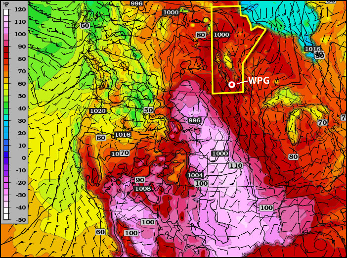
A ridge of high pressure will be in place over Manitoba on Monday and Tuesday of this week. This ridge will pump warm air into the province, allowing high temperatures to reach the high twenties and even low thirties. Monday will be quite nice, with temperatures in the high twenties over all of Southern Manitoba. Humidity levels on Monday will remain low, making the day rather comfortable. By Tuesday the humidity will increase somewhat, but will still remain reasonable even as temperatures climb to around thirty degrees (except in Western Manitoba where the air will be a bit more tropical). A cold front will slice through the province on Wednesday, knocking down humidity levels with a strong westerly wind. However, temperatures won’t drop off by much, with highs staying in the mid to upper twenties on Wednesday.

CAPE graphic. CAPE is a measure of how unstable the atmosphere is, in other words, how severe a storm could potentially become

CAPE values are expected to be moderate to extreme over the prairies early this week. CAPE is a measure of how unstable the atmosphere is, in other words, how severe a storm could potentially become

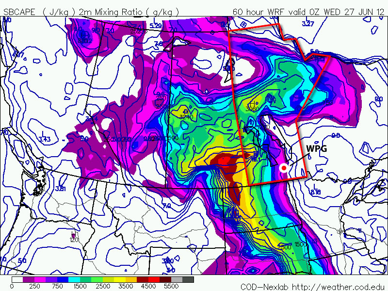
You may be wondering if this heat will generate thunderstorm activity as the cold front moves in on Wednesday. The short answer to that question is maybe, but I will elucidate. There will certainly be severe storms in Saskatchewan on Monday and Tuesday this week, but the threat in Manitoba is less clear. At this time it looks like our best chance for seeing storms will be on Tuesday night into Wednesday morning as storms that develop over Saskatchewan and North Dakota drift into Manitoba during the overnight period. Even though these storms will happen after dark they may still be severe as they will have warm and humid air to work with. There may also be the risk of thunderstorms during the day on Monday and Tuesday in portions of west-central Manitoba (i.e. Swan River, The Pas, etc). Since these regions aren’t our focus, I won’t go into much further detail than that. Nocturnal thunderstorms may drift into Western Manitoba on Monday night or Tuesday morning, but aren’t expected to impact the majority of Southern Manitoba.

After the cold front passes through on Wednesday there will be a couple of days where the heat “reloads” ahead of the long-weekend. In other words Thursday and Friday will be a bit cooler, although still warm, with temperatures more in the mid twenties. It is expected that hot weather will crank up again for the long-weekend, with present modelling suggesting that temperatures near thirty degrees will be possible on Saturday, Sunday, and Monday. It is too early to be certain in those predictions, but at this point the long-weekend is looking rather nice…if you like hot weather that is.

Tornado Threat To Develop Over Southern Manitoba on Saturday

3km EHI Values

3km EHI Values. This measures the potential strength of a tornado should one develop. As can be seen, the GFS EHI values have gone off the chart over extreme SW Manitoba on Saturday afternoon.

A slow-moving low pressure system pushing into our region will set the stage this weekend for the potential of supercell thunderstorms capable of producing localized flooding, extremely large hail, damaging wind gusts and tornadoes. Read past the break to get all the details, our thoughts on the main threat areas, and to see updated information in the comments.

Jump to Live Twitter Feed

An extremely slow-moving long-wave trough has been slowly pushing it’s way eastwards this week. While it’s been a good distance from us, we’ve been able to enjoy the benefits of such a setup: plenty of nice, warm weather with comfortable humidity. Our friends in the Western Prairies haven’t had it quite as nicely; multiple rounds of storms have pushed into Southern Alberta & Southwestern Saskatchewan over the past couple days, bringing multiple tornadoes to Southern AB and torrential rain that caused localized flooding after 2-3” fell in a short period of time. Large hail was also reported in many storms across the Western Prairies, as well as with some severe thunderstorms that developed over SE Saskatchewan on Wednesday evening.

Entrance of this system in our region has been marked by the thunderstorms and showers that developed overnight. We should see most of these clear from the Red River Valley this morning or by early afternoon if they’re really tenacious. We’ll see a relatively pleasant afternoon, with some lingering cloud and temperatures in the low-to-mid 20’s. The dewpoint will be quite high, making it feel a little sticky, though.

The main surface low begins to move into our area on Saturday, pushing a warm front up from North Dakota into extreme Southern Manitoba. Using the basic MIST principles of thunderstorm forecasting:

  • Moisture: Plentiful. Surface dewpoints will be sitting near 20°C across Southern Manitoba, with 850mb dewpoints pushing up towards 15-17°C. This deep layer of moisture will provide plenty of energy for storms to work with.
  • Instability: The major inhibition to storms will be a layer of warm air at 700mb. Temperatures will climb to 10-13°C at 700mb on Saturday morning, however cooler air will push in later in the afternoon, helping destabilize the mid-levels. LI values of -8 to -11, combined with CAPE values anywhere from 2500 J/kg to 5500 J/kg are evidence of an extremely unstable atmosphere.
  • Shear: With a decent upper-level jet pushing in through the day, most areas across southwest and south-central Manitoba will see bulk shear values increase to 30-40kt by evening.
  • Trigger: A warm front draped across Southern Manitoba will be strong enough to initiate convection in the mid-to-late afternoon as the cap begins to erode.

Prog Tephi for SW MB

Prognosis tephigram for Southwestern Manitoba on Saturday afternoon. Note the extremely favorable veering wind profile present.

Models strongly disagree about the speed of this system, but agree that it has a very strong potential to produce damaging supercell thunderstorms capable of producing tornadoes. The greatest uncertainty, then, is where exactly the storms may form. Unfortunately, as I write this it’s still too early to tell exactly where the greatest threat lies. The slowest solutions would place the main risk over extreme SE Saskatchewan across SW Manitoba, while the quicker solutions would place the risk over SW Manitoba into the Red River Valley. Personally, I feel that the slower solutions are probably a little more true to what’s going to happen. With that in mind, here’s my threat area for Saturday:

Day 2 Storm Outlook

Day 2 Thunderstorm Outlook, valid Saturday afternoon through Sunday morning. This is subject to refinement as this system develops and more certainty exists on it’s track and speed.

A large MCS will likely develop as the whole system lifts northwards overnight, which will continue to provide a severe weather threat in the form of strong winds and large hail. It will push through the RRV by Sunday morning. We may see the threat for another round of thunderstorms on Sunday afternoon, however they are not expected to be severe. Things will finally cool off on Monday as the main upper low moves through and draws in cooler, dryer air from the west.

We’ll be sure to refine the forecast in the comments below as the day approaches. In addition, it looks like the AWM crew will be out chasing, so we’ll be sure to have some live updates should everything work out. Stay sky aware out there this weekend!


new TWTR.Widget({
version: 2,
type: ‘list’,
rpp: 30,
interval: 30000,
title: ‘June 9, 2012’,
subject: ‘AWM Storm Chase’,
width: ‘auto’,
height: 500,
theme: {
shell: {
background: ‘#3c3c3c’,
color: ‘#eeeeee’
},
tweets: {
background: ‘#eeeeee’,
color: ‘#2c2c2c’,
links: ‘#489ce1’
}
},
features: {
scrollbar: true,
loop: false,
live: true,
behavior: ‘all’
}
}).render().setList(‘buffaloseven’, ‘awm-team’).start();

A Scorching Week to End With A Bang

Temperatures are set to soar for the remainder of this week as heat sourced from the Gulf of Mexico builds into Southern Manitoba. Residents across all of Southern Manitoba should begin to prepare for a potentially dangerous end-of-week though, as a powerful low pressure system will threaten the first significant severe weather outbreak of the season.

850mb Theta-E Chart for 06Z Thursday

850mb theta-e (a form of measuring temperature) chart valid for 06Z Thursday 07 May. The light-red arrows depict the advection of heat from the Gulf of Mexico through Southern Manitoba.

A southerly flow of air aloft, aided by a long-wave trough over the Rocky Mountains to our west and a blocking high to our east, will bring us our hottest days of the year through the rest of this week. Temperatures at 850mb are expected to rise to nearly 20°C today, which will result in daytime highs between 25-30°C through the second half of this week.

A weak low will move through Southern Manitoba on Thursaday night ahead of the main upper trough and while parameters don’t look too great for severe weather, a band of thunderstorms will likely develop in the late afternoon or early evening, intensify, and slowly move east-northeast. While tornadoes aren’t a likely threat with these storms on Thursday afternoon/night, CAPE values in the range of 1250-1750 J/kg combined with LIs near -5 and 20-30kt of bulk shear should provide enough for a threat of large hail. The slow-moving nature of the line of storms could potentially also produce a risk of locally heavy rainfall, with as much as 0.75-1.25” falling over a relatively short period of time. While showers will be commonplace over southwest Manitoba throughout the day on Thursday, the risk for showers does extend eastwards through the western and central Red River Valley in the afternoon. The bulk of precipitation will occur with the thunderstorms that develop in the evening, though.

This is still about 36 hours away, though, and things could change quite a bit between now and then. Models are having a hard time degrading the blocking pattern that’s in place right now, and some are much more progressive with features and some are much slower. If things end up more progressive than they look right now, there may be minimal storm threat for Thursday night.

Night 2 Thunderstorm Outlook

Thunderstorm Outlook for Night 2 (00Z to 18Z June 08).

Taking into account the various speeds, the current area that might see storms on Thursday afternoon/evening looks to be the area bounded from the US border north to Brandon, up towards Dauphin/Swan River, then eastwards across the Interlake and southwards down the eastern Red River Valley. Storms will exit through the Central/Northern Whiteshell. While the potential for heavy rainfall exists, I do not feel enough confidence in it to justify any slight risk categorization on the outlook. The storms will likely be marginally severe, though, so it’s important that they are not ignored with the prospect of even bigger storms on the weekend.

Friday looks to be another warm day; debris cloud left behind from Thursday night’s convection should clear bout by lunch time or early afternoon which will allow the sunshine to warm us up to the mid-to-high 20’s. Dewpoints will build through the afternoon pushing up to 18 or 19°C, making it feel quite humid. The main upper trough is set to move in on the weekend, though, and what a system it looks to be.

SPC Day 4-8 Outlook

SPC Day 4-8 Severe Thunderstorm Outlook

I’m not going to talk too much about Saturday’s setup yet, as it’s still a ways out and in this particular setup, the exact specifics are sure to change with every model run until it’s much closer. We’ll be under the influence of two strong shortwaves that will push copious amounts of instability over Southern Manitoba. CAPE values look to exceed 2500 J/kg and potentially be as high as 5000-5500 J/kg; this, combined with a weak cap north of the warm front and favorable shear profiles looks to point at a potent setup for severe thunderstorms with high probabilities of (extremely) large hail, strong winds, and elevated risks of tornadoes. The setup is similar to other tornado-producing setups of years past, including the Pipestone tornado of 2007.

We’ll have plenty of discussion about the upcoming storm threats in the comments, so be sure to check back often for the latest information about this weekend’s potentially dangerous storm outbreak.

Showers and Thunderstorms on Tap for Southern Mantioba

While temperatures will soar to the 30°C mark today, much of the Red River Valley should be prepared for showers and thunderstorms to develop by mid-to-late afternoon as a low pressure system moves into the area and taps the available heat and moisture.

850mb Theta-E Values

850mb Theta-E values at 00Z May 19th (this evening) from the NAM. A sharp warm front is evident jsut north of the US border in Southern Manitoba.

With a strong capping inversion in place over the Red River Valley today, heat and moisture being pumped northwards will be trapped at the surface, allowing our temperature to soar to the 30°C mark and pooling moisture that will push our dewpoints up to around 15°C. Much of the day will be a beautiful day, especially given that it’s only May 18th. Conditions will deteriorate somewhat by late afternoon, though, as a surface low lifts northwards into Southern Manitoba.

The surface low will travel along a pre-existing surface trough and be supported by a shortwave ejecting northeastwards from the main upper trough, still anchored through Montana and Wyoming. With the heat trapped near the surface, the Lifted Index is expected to drop to the -2 to -8 values, with the lowest values running along a line from Gretna, MB to Bisset, MB and increasing to the southeast of that line. The heat combined with ample moisture is also expected to produce high CAPE values generally from 2000 to 3000J/kg. Increasing mid-level lapse rates with the approach of the shortwave will provide enough destabilization to erode the capping inversion through the afternoon and allow showers and thunderstorms to develop along and ahead of the warm front, initially concentrated near the triple point of the system. The showers and thunderstorms will expand in coverage as the evening progresses and the low-level jet intensifies.

Severe Weather Threat

Today marks one of the first severe weather threats of the season. Things look promising, and have even caught the attention of some seasoned storm chasers from the United States:

On paper, things look fairly good that there’s a risk for severe weather. EHI values rise to between 1.5-2.0 by late afternoon, which when combined with the presence of 30-35kt of bulk shear certainly presents the chance for supercell storms to develop. A few things hamper my excitement, though:

  • Bulk shear isn’t really all that impressive; the really good shear moves through Western Manitoba through the day today, lifting northwards into the Interlake. The shear diminishes to the SE and isn’t particularly strong where the greatest CAPE is. When it comes down to it, it’s likely that we’ll end up with marginally strong shear on top of marginally high CAPE this afternoon, with the most favorable conditions missing each other.
  • CAPE values may be too high. The NAM & GFS have been forecasting dewpoints slightly higher than have materialized. The amount of energy for storms to work with is going to be heavily dependant on the dewpoints that develop this afternoon, and if they don’t make it as high as forecast then we’ll be seeing weaker storms.
  • Too many storms. With so many marginally severe features, we may see quite a few showers and thunderstorms develop this afternoon as the cap erodes. If too many fire off, then it will be difficult for any one storm to oragnize itself into anything that poses a severe weather threat.

All that being said, a potential for severe weather does exist today across south-central and southeast Manitoba. The main threats should severe weather develop will be hail and/or the possibility of a tornado.

Thunderstorm Outlook for May 18th

Thunderstorm Outlook for May 18th to May 19th. Please note: Analysis has only been done for Manitoba. Storms may develop elsewhere in the Canadian Prairies.

Residents in Southern Manitoba should stay up-to-date on the weather today to ensure that if severe storms do develop, the appropriate precautions can be taken.