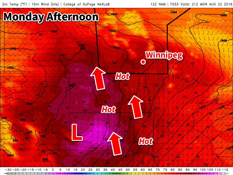
The heat will return early this week as temperatures climb up to the thirty degree mark. This warm and humid air mass will also bring another risk of thunderstorms to southern Manitoba on Tuesday.
Hot weather is in store for southern Manitoba early this week
This Week
Today will be a hot one in southern Manitoba. Temperatures are expected to climb into the low thirties in most areas. The humidity will begin to climb as well, with dewpoints reaching the upper teens in most areas by late Monday – although locally higher dewpoints will be possible. Despite these hot and humid conditions it doesn’t appear that we’ll see any storms today. The atmosphere is expected to be capped, preventing thunderstorms from developing. There is a slight risk of storms overnight, but conditions don’t look particularly good for widespread development.
Tuesday will be the more interesting day storm-wise, as humidity increases further. A low pressure system is expected to sit over southern Manitoba by midday Tuesday, maintaining a south to southeast surface flow over the Red River Valley and southeastern Manitoba. Instability will be high with the hot and humid conditions, while wind shear is also strong because of the approach of a strong upper-level trough. These conditions should be favourable for the development of severe thunderstorms. High temperatures should end up near 30C with the humidex in the upper thirties. Skies will be mainly sunny before storms begin to develop.
A strong cold front is expected to slice through southern Manitoba on Wednesday morning. This front will drop temperatures down to near the 20C mark. The front will also take advantage of the lingering humidity in the atmosphere to produce shower activity over most of southern Manitoba. Following the frontal passage, it will become quite gusty as well, with northerly winds of 40 km/h gusting to 60 km/h.
Long Range
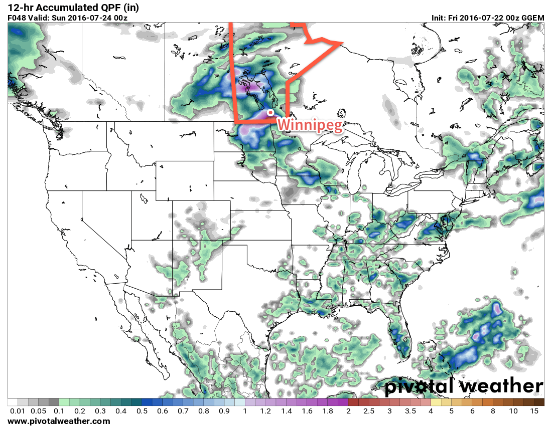
It appears that temperatures will begin to rebound later this week following the passage of that cold front on Wednesday. Temperatures approaching the 30C mark may be possible again by the weekend – although models are still unclear as to how long and intense this next burst of heat will be.
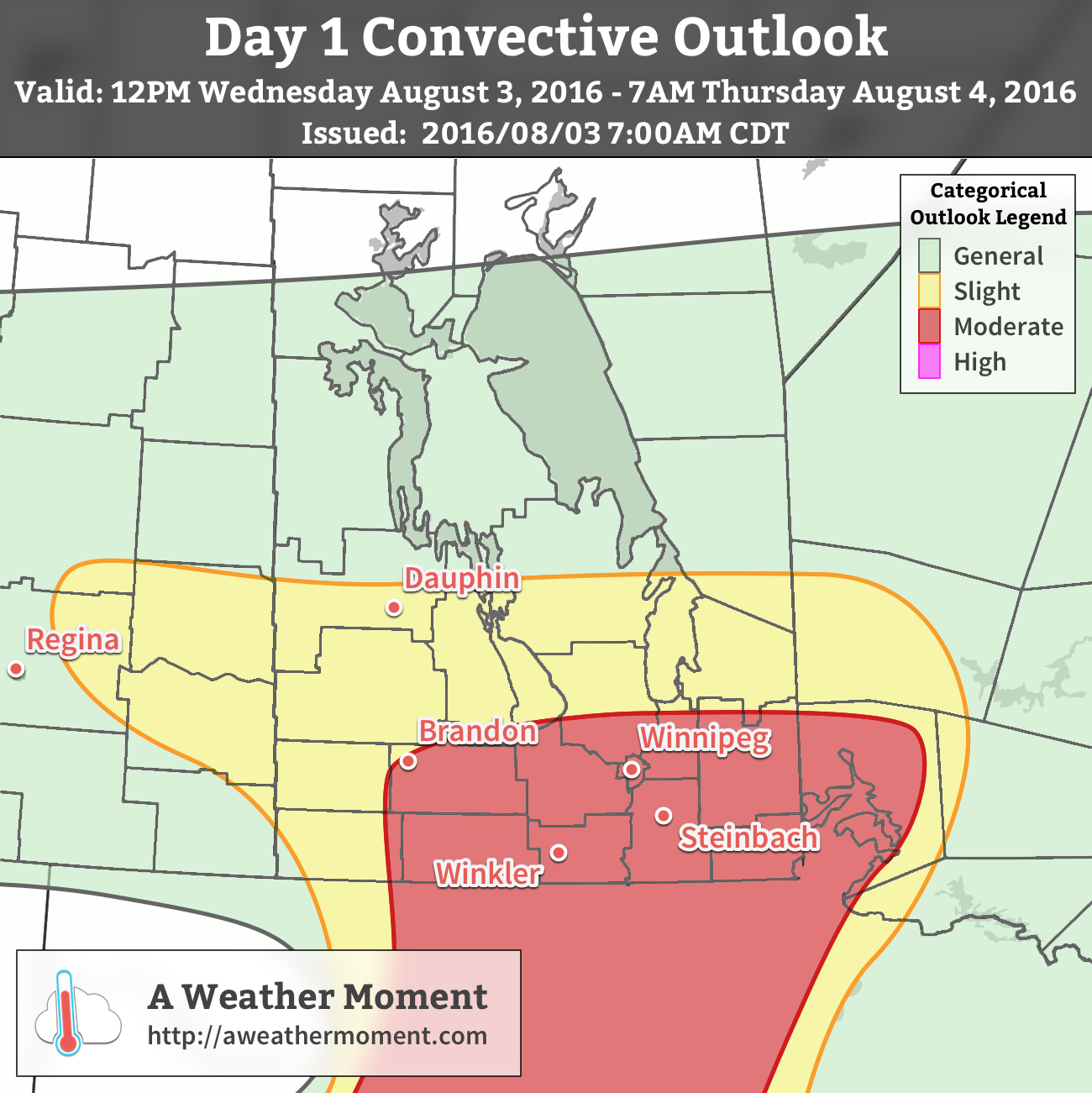
A low pressure system tracking eastwards through Saskatchewan will bring a potent severe thunderstorm threat to Southern Manitoba today. The development of severe thunderstorms capable of producing damaging hail and winds, torrential downpours, and tornadoes is expected this afternoon over portions of southwestern Manitoba. These thunderstorms will then track eastwards across the Red River Valley & the southeastern corner of the province through the evening hours.
Hot and humid weather will return to Winnipeg today as temperatures soar to the 30°C mark while dewpoint temperatures climb towards the 20°C mark in the Red River Valley courtesy a gusty southeasterly wind of 30-40 km/h that will develop midday. This hot and humid weather will serve as the pressure cooker for severe thunderstorm development as a low pressure system tracks into the province this afternoon.
Through the morning hours, a few isolated thunderstorms are possible across the southwestern and south-central portions of the province, but they aren’t expected to be particularly notable. By early to mid-afternoon, the “main event” will start with thunderstorms developing along a north-south line west of the Red River Valley. Through the late afternoon into the evening, these thunderstorms will move eastwards across the Red River Valley and southeastern Manitoba.
These thunderstorms will be capable of producing large and damaging hail, dangerous straight-line winds exceeding 100 km/h, and torrential downpours capable of flash flooding. In the early hours of the system, over portions of southwestern Manitoba and possibly extending into the western Red River Valley, these thunderstorms will also be capable of producing a tornado.
Moisture: Dewpoints climbing into the 20-23°C range will combine with moderate vertical extent as an organized moisture feed advects into the province from the Dakotas.
Instability: Significant moisture coupled with moderate mid-level lapse rates to produce MLCAPE values 2000-3000 J/kg. MUCAPE values of 1500-2000 J/kg will continue overnight into northwestern Ontario.
Shear: Significant speed and directional shear will be in place over the province with textbook-quality looping hodographs present under 50-60 kt of 0-6km bulk shear will practically guarantee supercell development upon storm initiation and will be completely supportive of upscale growth into the overnight period.
Trigger: A frontal wave passing by the province and associated low pressure system and trough will provide ample lift and convergence to trigger thunderstorm development.
As storms develop, they will very quickly begin rotating and mature into supercell thunderstorms. These storms will very quickly develop hail and severe wind threats. Low lifting condensation levels coupled with the strongly veering hodographs and notable low-level CAPE also suggests a tornado threat for the first few hours of the storm life-cycle. This will most likely be constrained in an area from Brandon to Winnipeg along the Trans-Canada Highway and then south to the American border.
The severe thunderstorm threat will continue eastwards with the line through the evening into Ontario.
AWM Day 1 Convective Outlook for August 3, 2016
The thunderstorms will track eastwards through the evening hours, with Winnipeg most likely seeing the activity between 8PM and 1AM.
Winds will diminish tonight behind the thunderstorm activity as temperature dip to around 17°C.
Update: EC Event Summary
Environment Canada has issued a summary of the severe weather that occurred across #MBstorm yesterday. The highlights are two confirmed tornadoes, loonie to quarter sized hail, wind gusts up to 111 km/h, and 4″ of rain!
Weather summary for Manitoba
issued by Environment Canada
at 5:04 a.m. CDT Thursday 4 August 2016.

Discussion.

An intense low pressure system tracking across the Prairies brought
widespread severe weather to much of southern Manitoba on Wednesday.
Two tornadoes have been confirmed, and numerous reports of heavy
rain, damaging winds, and large hail were also received.

The following reports have been received by ECCC meteorologists
(event times are approximate):

A funnel cloud was reported 8 km north of Hartney at 5:00 pm CDT.

A brief tornado was reported near Margaret at 5:10 pm CDT. No damage
was reported with this tornado.

A larger, longer lived tornado was reported 10 km west of Baldur at
5:20 pm CDT. It tracked northwards towards Stockton where a large
shed was destroyed shortly after 5:30 pm CDT.

ECCC meteorologists continue to investigate these and other
unconfirmed tornadoes.

Hail reports:

Loonie sized hail at Brandon at 6:05 pm CDT.
Quarter sized hail at Shoal Lake at 9:20 pm CDT.
Loonie sized hail at Wasagaming at 10:10 pm CDT.

Peak wind gust reports:

111 km/h at Morden at 7:26 pm CDT.
93 km/h at Portage la Prairie at 7:10 pm CDT.
92 km/h at St. Adolphe at 9:05 pm CDT.
85 km/h at Gretna at 7:46 pm CDT.
74 km/h at Winnipeg Airport at 9:45 pm CDT.

Rainfall totals in millimetres:

Erickson 104
Neepawa 75
Glenboro 66
St. Adolphe 64
Holland 56
Ethelbert 53
Fisherton 53
Morden 53
Killarney 50
Souris 49
Cypress River 45
Elm Creek 43
Snowflake 43
Winnipeg The Forks 2.7
Winnipeg Airport 1.4

Environment and Climate Change Canada meteorologists are actively
seeking pictures or videos from Wednesday's severe weather events
and further damage they may have caused. Should you have any
information regarding these events or to report severe weather at
any time, please call 1-800-239-0484, email storm@ec.gc.ca, or tweet
#MBStorm.

Please note that this summary may contain preliminary or unofficial
information and does not constitute a complete or final report.

End/PASPC
The Rest of the Week
Thursday will be a cooler day with a high near just 21°C with gusty northwesterly winds at 30-40 km/h. There will be a slight chance of some showers as the wrap-around from this low moves across the province. The humidity will be flushed out of the province making for more comfortable conditions. Temperatures will dip to 13°C Thursday night with clearing skies and diminishing winds.
Friday will be a pleasant day with winds out of the northwest at 20-30 km/h, highs in the mid-20’s and mainly sunny skies.
Winnipeg’s seasonal daytime high is currently 26°C while the seasonal overnight low is 13°C.
Heat and humidity will build back into Southern Manitoba this weekend, bringing both mid-summer warmth and the returning threat for severe thunderstorms.
Today will be a beautiful day for Winnipeg & the Red River Valley as a ridge of high pressure exiting the region continues to bring mainly sunny skies. Winds will remain light out of the south as temperatures climb to a high near 27°C. Tonight, under a few clouds, temperatures will dip down to near 14°C.
The weather pattern will begin to change on Saturday as a low pressure system developing over the Prairies begins drawing warmer, more humid air northwards into Manitoba. Daytime highs will be similar to Friday, around 27°C, however the humidity will begin to become a little more noticeable by the end of the day as the dewpoint climbs to the 16 or 17°C mark. Alongside the increasing humidity will come a slight chance of some late afternoon or early evening thunderstorms. The severe potential looks fairly limited at this time, as does the overall ability for any storms to organize, so while an isolated strong-to-severe storm may be possible, no widespread or organized severe threat is expected.
Temperatures will then dip down to around 17°C on Saturday night with a few clouds.
Dewpoint temperatures climbing to near the 20°C mark will make for a muggy Sunday.
Sunday will see the warmest air move into the Red River Valley alongside an increment in humidity. Daytime highs will climb to near the 30°C mark along with dewpoints rising to near the 20°C mark, making it feel quite muggy. Humidex values, a "feels like" temperature that combines temperature & humidity values, will be in the upper 30's, making for quite a hot day. Skies will be mixed, and a breezy southerly wind will be in place through the Red River Valley at 20-30 km/h.
Sunday night will be a warm one with temperatures dropping only to around 20°C. A threat for thunderstorms return with a likely severe threat. Over 2500 J/kg of MLCAPE will be in place over parts of the province, alongside 35 kt of bulk shear and strongly veering wind profiles. This suggests an all-threats severe hazard, including a tornado threat in the early hours of storm initiation over Southwestern Manitoba. As the thunderstorms progress eastwards, the threat will likely shift to strong wind and large hail.
Long Range
Next week is looking like a return to more unsettled weather. Uncertainty exists with the thunderstorm system at the end of the weekend, with some models suggesting a slower progressing system that would result in more of a rain/storm threat on Monday instead. After a brief reprieve from that system, another one looks to be on the doorstep for mid-week that will bring another chance for rain and thunderstorms. Following that, the week will end off slightly cooler than seasonal.
Winnipeg’s seasonal daytime high is currently 26°C while the seasonal overnight low is 13°C.
The heat seen over southern Manitoba over the past week will be in place for just one more day before a low pressure system moves through the region on Saturday, bringing soggy weather and cooler temperatures.
Another hot day is on the way for Winnipeg, but humidity will continue to decrease slightly towards more comfortable levels. Winnipeg & area will see plenty of sunshine today with just a few puffs of cloud possible in the afternoon. Winds will be fairly light out of the west-northwest at 15-25 km/h. Temperatures will climb to a high near 28°C. Tonight will bring increasing cloud and light winds as temperatures dip to around 18°C.
A low pressure system will be pushing northeastwards out of Saskatchewan & Montana on Friday night.
Saturday will be an unsettled day as a low pressure system moves through the province. The daytime high will be in the mid-20’s with winds picking up out of the south to 20-30km/h in the morning.
There will be rain on Saturday, however at this point, there’s still some uncertainty on exactly where precipitation will fall. Indications are that amounts will generally be 5-15 mm, however convective elements may produce rainfall amounts up to 30-50 mm in thunderstorm activity.
One potential outcome of Saturday shows two main areas of convective rainfall with up to 50 mm of rain.
Ultimately we’ll simply have to wait and see how things shape up and what the nature is of the precipitation that develops through Montana and Saskatchewan tonight. We’ll provide updates in the comments below.
Much of the rain will taper off on Saturday evening, leaving us with fairly cloudy skies and a low that falls to around 16°C by Sunday morning.
Sunday will be a bit of a mixed bag. Expect mixed skies and a high near 26°C, however winds will be breezy, peaking out of the northwest at around 40 km/h and we’ll see just a slight chance of some scattered showers. Skies should clear for Sunday night as temperatures head to a low near 16°C.
Long Range
The start of next week looks fairly pleasant with sunny to mixed skies and daytime highs in the mid- to upper-20s. It looks like it will be fairly dry with a ridge of high pressure deflecting things south of the Red River Valley, but that will be sensitive to the exact location that this feature sets up.
Winnipeg’s seasonal daytime high is currently 26°C while the seasonal overnight low is 13°C.