Another Brief Reprieve Before Heat & Humidity Return

Winnipeg will see a one-day break before heat and humidity builds back in for the weekend.

Conditions will be calm, comfortable, and quiet in Winnipeg today. A ridge of high pressure will move into the region today behind a cold front that passed through overnight. This ridge will bring plenty of sunshine to the region as temperatures climb to a high near 24°C. A northwesterly wind near 20 km/h will persist through much of the day, then diminish through the evening. Skies will stay fairly clear tonight as temperatures drop to a low near 16°C.

Heading into the weekend, a weak upper-level ridge will usher heat and humidity back into the region. For both Saturday and Sunday, daytime highs will climb to 29 or 30°C and overnight lows near 20°C. The humidity will build on Saturday with dew points climbing into the upper teens. For Sunday, dew points will rise back to the 20°C mark, similar to Thursday afternoon. The humid conditions will result in Humidex values in the mid-30s. Winds will be light out of the south on Saturday at around 15 km/h, but pick up into the 20 to 30 km/h range on Sunday.

Very humid conditions are forecast to re-develop over southern Manitoba on Sunday through Sunday night.

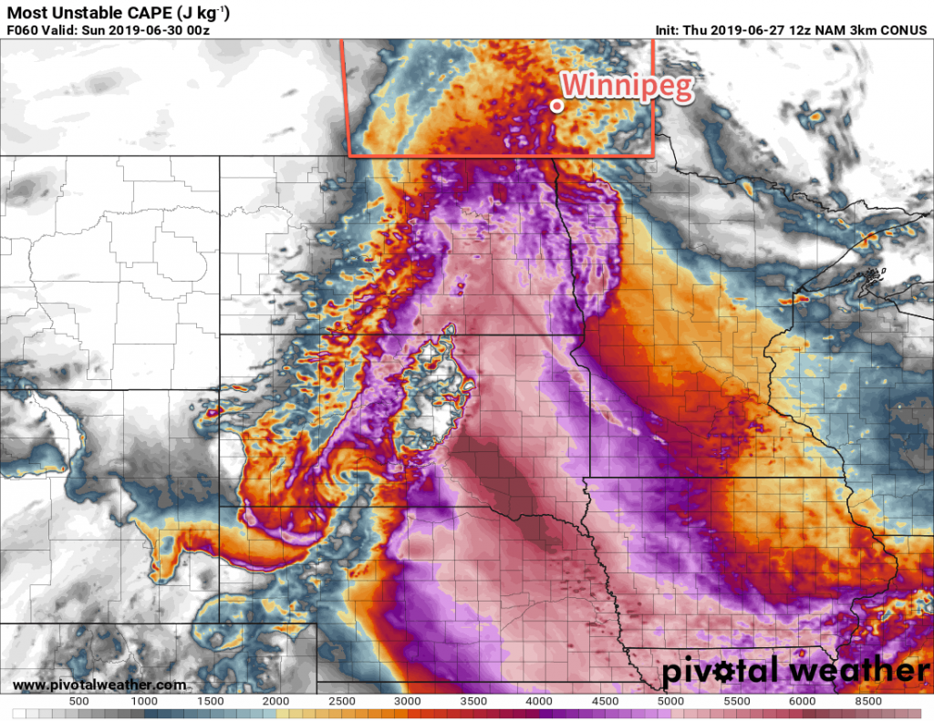
As far as active weather goes, the city will see a few chances for thunderstorms. The first will be on Saturday afternoon as a warm front pushes through the region. The second will be Sunday morning as an area of nocturnal convection moves through the region. Both are highly conditional, so be sure to stay tuned for any watches or warnings issued by Environment and Climate Change Canada through the weekend.

All in all prepare for a hot and muggy weekend with variable cloudiness and a couple chances for thunderstorms!

Long Range Outlook

Next week looks to bring seasonably warm conditions with slightly less humidity. The muggiest air will clear out on Monday with the chance for more thunderstorms. Then the remainder of the week will bring daytime highs in the 27 to 30°C range with overnight lows of 17 to 20°C. The city will likely see plenty of sun, but the overall pattern is slightly unsettled. As a result, there will likely be several chances of thunderstorms through the week.

Today’s seasonal daytime high in Winnipeg is 26°C while the seasonal overnight low is 13°C.

Sunshine Returns with Chance of Thunderstorms on Thursday

Winnipeg will see plenty of sun through the rest of the week, but humid weather returns on Thursday with another round of thunderstorms possible.

Today will bring sunshine back to the region with northwesterly winds help get things drying out after yesterday’s deluge. After the chance of a few morning showers, skies should clear out and temperatures will climb to a high near 25°C for the afternoon. The winds will diminish this evening, leaving the city with a few clouds as temperatures head to a low near 13°C.

The settled weather won’t last long, though. Another low pressure system will move into the region from the west on Thursday. Ahead of the low, humid conditions will once again develop and temperatures will climb to a high near 28°C. Skies will be mixed through the day with moderate southerly winds of 30 to 40 km/h developing in the afternoon.

Very humid conditions will develop over southern Manitoba on Thursday afternoon. Dew point values are forecast to climb above 20°C.

Thunderstorms will initiate in the afternoon over WestMan into the Interlake in the afternoon, then move southeastwards. The storms will likely enter the Red River Valley near 6-7 PM and push through over the next couple hours. The main threat from these thunderstorms will be large hail and damaging winds, but the humid conditions will also support heavy rainfall. Shortly after the trough moves through, a weaker cold front will slump south through the region. There may be a few showers or isolated thunderstorms along the front as it passes, but it will carry no severe weather threat. The cold front will move through after midnight leaving behind mixed skies as temperatures dip to a low near 16°C.

The city will see partly cloudy skies on Friday as a weak ridge of high pressure moves through the region. Temperatures should reach a high near 24°C and humidity levels should be more comfortable. Winds will be light out of the northwest. Friday night will be pleasant with a low near 13°C under clear skies.

Long Range Outlook

The weekend is looking warm with highs approaching 30°C and increasing humidity. As a result, overnight lows will also be warm, likely close to the 20°C mark. Winnipeg is not forecast to get any rain, but disturbances will pass to the south and the north of the city so there will be a low chance of a passing shower or two.

Today’s seasonal daytime high in Winnipeg is 26°C while the seasonal overnight low is 13°C.

Hot and Humid Conditions Ahead

Temperatures will soar this weekend in Winnipeg as a hot and humid air mass moves in from the south.

A building upper ridge will push increasingly hot and humid conditions into southern Manitoba this weekend. The first push of heat will arrive today with the temperature climbing to around 30°C in Winnipeg. Skies will stay mostly sunny through the day with light winds. Tonight will be warm with a low near 18°C.

Saturday will be another hot day with increasing humidity. The city will see variable cloudiness through the day depending on (a) how much blow-off from overnight thunderstorms in Saskatchewan and western Manitoba moves through in the first half of the day, and (b) how much thunderstorm activity develops in the afternoon. Winnipeg should see a high near 31°C, but may be warmer or cooler depending on how much sunshine there is. Dew points will gradually climb through the day, reaching the mid- to upper-teens by the end of the afternoon. Combined with the warm temperatures, this will result in humidex values in the upper 30s.

The thunderstorm threat for the day is largely conditional; a strong capping inversion will likely preclude any surface-based convection through the afternoon. There will be steep mid-level lapse rates coupled with strong dynamics that may support elevated convection, though. The first organized threat will be midday if any convection from Friday night manages to survive through the morning. Conditions should be more settled for the afternoon, then a risk for thunderstorms will redevelop late in the day. We recommend you view ECCC’s Thunderstorm Outlook on Saturday morning for the authoritative look at the day’s convective potential. You’ll be able to view it in our Bulletin Viewer.

The warm conditions continue on Saturday night as winds ease off and then turn northwesterly by Sunday morning. Winnipeg will see a low near 19°C.

Sunday will usher in drier conditions as breezy westerly winds up to 30 gusting 50 km/h develop. Temperatures will again climb to around 30°C, but dew points will drop back into the single-digits, making for more comfortable conditions. Any leftover cloud in the morning will quickly clear out, leaving behind partly cloudy skies for the rest of the day. Temperatures will dip to a mild low near 17°C on Sunday night with winds easing.

Long Range Outlook

Next week will bring a fair amount of sunshine to the region with daytime highs generally in the 25 to 30°C range. No major precipitation events are forecast, however there may be one or two chances for thunderstorms through the week.

Today’s seasonal daytime high in Winnipeg is 25°C while the seasonal overnight low is 12°C.

Hot, Humid Summer Weather Arrives

Get the air conditioners ready: hot and humid weather is on the way for Winnipeg.

Winnipeg will see the first true blast of summer heat as a muggy Gulf of Mexico air mass builds into the region tonight. While daytime highs will be similar to those seen over the past few days, dew points climbing into the upper teens will bring warm overnight lows and muggy conditions on Thursday afternoon with humidex values in the mid-30s.

However, with this hot and humid weather will come the first significant thunderstorm threat of the year. Winnipeg will see increasing cloudiness Wednesday evening and a slight chance of showers or thunderstorms overnight. There should then be a reprieve with mixed skies until Thursday afternoon when an upper-level disturbance begins working into the region. Most of the thunderstorm activity should hold off until later in the day, but it’s likely that showers and thunderstorms develop in the evening.

RDPS 2m Dew Point Forecast valid 21Z Thursday May 24, 2018
Dew points will climb to nearly 20°C on Thursday afternoon in Winnipeg, making for a very humid afternoon.

Looking at the MIST principles:

  • Moisture: Deep moisture with dew points in the upper teens will provide plenty of energy for the storms to work with.
  • Instability: Moderate with MLCAPE values near 3000 J/kg transitioning to around 2500 J/kg of MUCAPE as the evening progresses.
  • Shear: Will be low to moderate with roughly 20 to 25 kts of bulk shear.
  • Trigger: An incoming shortwave will provide mid-level destabilization to help initiate convection.

All this combines for a threat of severe thunderstorms with primary threats of large hail and wind gusts in excess of 90 km/h. The high dew points will also support heavy rain with localized amounts of 30 to 50 mm possible as the shortwave moves in on Thursday night.

Thursday afternoon will also bring some breezy conditions with winds out of the south near 30 km/h.

Friday will bring potentially unsettled conditions as an upper low moves through the region. With relatively humid conditions still in place, mixed skies are likely with scattered showers or thunderstorms moving through the region.

Long Range Outlook

A bit of relief from the heat will arrive for the weekend with daytime highs cooling slightly on Saturday and humidity levels dropping. The heat quickly builds back in on Sunday with highs near 30°C again.

Next week looks to kick off with an unsettled and warm trend. Daytime highs in the upper 20’s look likely, along with mixed skies and several chances for showers or thunderstorms.

Winnipeg’s seasonal daytime high is currently 21°C while the seasonal overnight low is 7°C.