Warm Weather Ahead

Warm summer weather will continue through the weekend in Winnipeg.

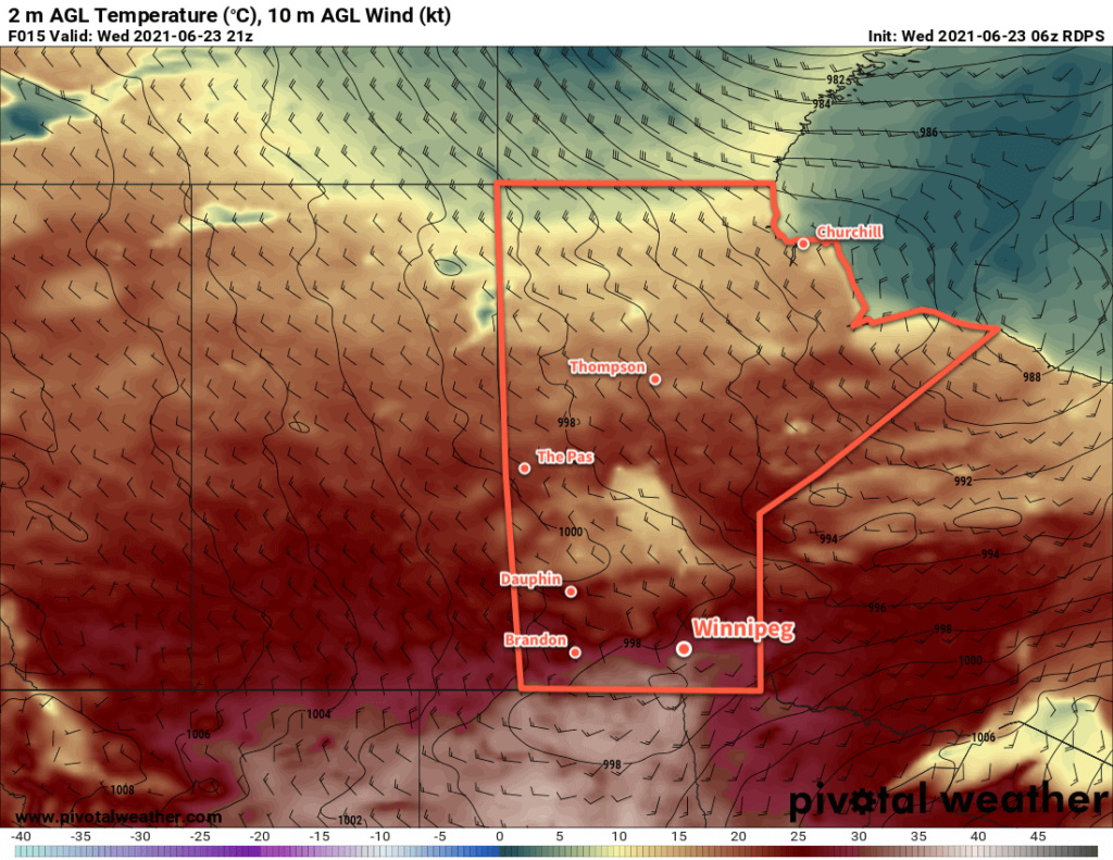
Summer heat returns to southern Manitoba with highs in the low 30s today. Winnipeg will see temperatures climb to a high near 30 °C before a cold front begins slumping into the region. As the front moves in this afternoon, the city will see increasing cloud cover with a good chance of showers. There will also be a chance for a few thunderstorms afternoon with a small chance of a marginally severe thunderstorm. The primary threats from any thunderstorms that develop would be damaging hail and/or damaging wind gusts. The showers and thunderstorms will push off into northwestern Ontario this evening.

The city will see a breezy start to the day with southerly winds of 30 gusting 50 km/h. The winds will ease midday as the cold front approaches, then pick up out of the northwest to 30 gusting 50 km/h this evening. Skies will clear out with easing winds overnight as temperatures head to a low near 13 °C.

RDPS 2m Temperature Forecast valid 21Z Wednesday June 23, 2021
Hot weather will push back into southern Manitoba today with highs in the low 30s along and south of the Trans-Canada Highway.

Winnipeg will see a quieter day on Thursday with sunshine in the morning and a few clouds in the afternoon. Temperatures will climb to a high near 27 °C with a northwest breeze around 20 km/h. Heading into the evening, an upper-level disturbance tracking along the international border will spread more cloud into the region. Showers will push into southwestern Manitoba in the evening, then onwards towards the Red River Valley. There will be a chance for Winnipeg to see some rain from this overnight, but the rain may end up slumping a bit further south and missing the city.

Temperatures will head to a low near 15 °C on Thursday night.

On Friday, a broad ridge of high pressure will bring plenty of sun to the region. Temperatures will again climb to a high near 27 °C with light winds. More cloud will push into the region on Friday night ahead of another disturbance moving into the region from the northwest. Temperatures will head to a low near 16 °C overnight.

Long Range Outlook

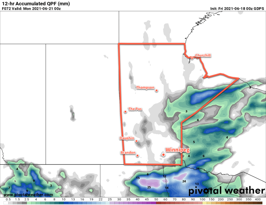
Warm weather will continue through the weekend in Winnipeg with highs in the upper 20s and lows in the mid-teens. The city will likely see mixed skies on Saturday with a chance of showers or thunderstorms later in the day, while Sunday should bring more sun back to the region. A potent upper high building into the Prairies next week will bring an extended period of sunny weather with highs in the upper 20s or low 30s.

Today’s seasonal daytime high in Winnipeg is 24 °C while the seasonal overnight low is 12 °C.

A Cooler Weekend Ahead for Winnipeg

A series of low pressure systems will bring cooler weather to Winnipeg for the weekend.

A cold front sweeping through the Red River Valley will bring substantially cooler temperatures to Winnipeg today. The front will move through this morning and usher in moderate northwest winds up to 40 gusting 60 km/h and cloudier skies. Those northwest winds will bring notably cooler temperatures to the region; Winnipeg will see a below-seasonal high around 18 °C.

Skies will clear this evening with easing winds. Temperatures will head to a low near 9 °C.

Temperatures will rebound back to seasonal values on Saturday. A weak warm front pushing into the region will send Winnipeg’s high to around 24 °C. The city will see plenty of sun with partly cloudy skies in the afternoon. Temperatures will head to a low near 14 °C on Saturday night with rain likely beginning by Sunday morning.

GDPS 12-hr Accumulated Precipitation Forecast valid 00Z Monday June 21, 2020
While many weather models show rain for Winnipeg on Sunday, some—like this GDPS run—keep things dry through the Canadian Red River Valley.

Sunday will likely bring morning rain to Winnipeg as a frontal wave passes along the international border. The city could see as much as 5 to 10 mm of rain before it eases midday. For the second half of the day, the cloud cover will begin to break up as moderate northerly winds of 40–50 km/h develop. These winds will keep the temperature cooler as well; Winnipeg will see a high near 17 °C on Sunday.

Skies will clear with a low near 6 °C on Sunday night. The wind is forecast to ease into the 20–30 km/h range overnight.

Long Range Outlook

The cool weather will persist through the first half of next week. Daytime highs will gradually climb from the mid-teens to seasonal values by Wednesday. Mainly sunny conditions should be in place to start the week, but more unsettled conditions are forecast for the latter half.

Today’s seasonal daytime high in Winnipeg is 24 °C while the seasonal overnight low is 11 °C.

A Few More Showers Before the Sunshine

Winnipeg will see a few more showers or thunderstorms today before sunnier conditions return to the region.

A low pressure system lifting through the province this morning will bring more unsettled weather to the Red River Valley. This system produced widespread thunderstorm activity over Montana and southern Saskatchewan yesterday that continued through the night and moved into southern Manitoba. The remnants of that nocturnal convection will move over the Red River Valley this morning, bringing a good chance of showers or thunderstorms to Winnipeg through the morning hours. Once this initial line passes, some sunny breaks should develop for the afternoon hours.

NAM Simulated Reflectivity Forecast valid 15Z Friday June 11, 2021
A band of showers and thunderstorms is forecast to move across the Red River Valley early Friday morning.

Winds will be breezy out of the southeast through the morning near 30 gusting 50 km/h. Once the line passes, they’ll shift southerly and strengthen to 40 gusting 60 km/h for the afternoon. Temperatures will reach a high around 21 °C today then head to a low near 14 °C tonight with clearing skies. Winds will stay out of the southwest overnight as they ease to around 30 km/h.

On Saturday, the upper-level pattern will change as a broad ridge begins building over western Canada. This will bring sunny skies to Winnipeg for the weekend with highs climbing into the upper 20s. Westerly winds will continue on Saturday at around 30 km/h, then ease on Saturday night. The winds will stay light on Sunday as a high pressure system moves into the province.

Long Range Outlook

The sunny and warm weather will continue through next week with highs in the mid- to upper-20s, lows in the mid- to upper-teens, and comfortable humidity levels.

Today’s seasonal daytime high in Winnipeg is 23 °C while the seasonal overnight low is 10 °C.

More Unsettled Weather for Winnipeg

Winnipeg will see a couple more chances for showers or thunderstorms this week as unsettled conditions stretch to the weekend.

A low pressure system moving into the province overnight brought widespread showers and thunderstorms to the province. Any remaining activity that moved on overnight will drift off to the northeast this morning, leaving behind mixed to cloudy skies. Temperature will warm up quickly through the morning, reaching around 27 °C by midday. The warmth will be accompanied by humid conditions — dew points will climb into the upper teens — and provide a moderate amount of energy for the redevelopment of thunderstorms.

RDPS 2m Dew Point Forecast valid 21Z Wednesday June 9, 2021
Showers and thunderstorms will help produce humid conditions over southern Manitoba today.

A shortwave moving into the region will provide a trigger for storm development later today. As it crosses the Red River Valley midday, it will bring showers and thunderstorms with a low risk of isolated severe thunderstorms. The primary threat from these thunderstorms will be torrential downpours and marginally severe hail.

Skies will stay on the cloudier side tonight with a low near 14 °C.

Thursday will see a brief lull between disturbances. Temperatures will climb to a high near 24 °C under mainly cloudy skies. The city will see northerly winds through the day at around 20 km/h. Temperatures will dip to a low near 17 °C on Thursday night with a chance of showers or thunderstorms overnight.

RDPS 12-hr Accumulated Precipitation Forecast valid 00Z Saturday June 12, 2021
A broad area of rain and showers will move through the eastern Prairies on Friday with areas of relatively high rainfall totals.

A low pressure system will lift through the Prairies on Friday, bringing more rain to southern Manitoba. A broad area of showers will move through the region with a risk of thunderstorms. There will be little to no risk of severe weather with this system. The rain will keep temperatures a bit cooler with a high near 22 °C. The wind will shift from easterly near 20 km/h in the morning to south-southwest at 30–40 km/h in the afternoon. Skies will clear out late in the day with diminishing winds. Winnipeg will see a low near 14 °C on Friday night.

Long Range Outlook

A stretch of warm, dry weather will develop this weekend into next week. Winnipeg will see plenty of sunshine with highs of 25–30 °C and lows in the teens. Humidity levels look to stay comfortable right through the next week.

Today’s seasonal daytime high in Winnipeg is 23 °C while the seasonal overnight low is 10 °C.