Turning Unsettled As Warm, Humid Weather Arrives

A warm and increasingly humid air mass will move into Winnipeg this week, bringing chances for showers or thunderstorms to the region.

An upper-level disturbance moving through southern Manitoba will bring cloudy periods to Winnipeg today. There will be a chance of showers, but most of the rain will pass to the north of Winnipeg. The best chance for any rain will be in the morning and midday hours. Temperatures will warm up in the afternoon with some sunshine poking through the clouds to a high near 26 °C. Skies will clear out tonight with a low near 15 °C.

Tuesday will start the move towards a warmer and more humid air mass. A sharp upper-level trough will dig over the western seaboard with an upper ridge over the eastern Prairies developing in response. Skies will stay mainly sunny as a warm front begins lifting towards Canada through the Northern Plains. Winnipeg will see light northeasterly flow ahead of the warm front through the day as temperatures head to a high near 30 °C.

RDPS 12-hr Accumulated Precipitation Forecast valid 12Z Wednesday June 9, 2021
Showers and thunderstorms will develop in the United States on Tuesday night and spread across southern Manitoba by Wednesday morning.

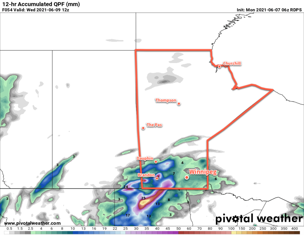
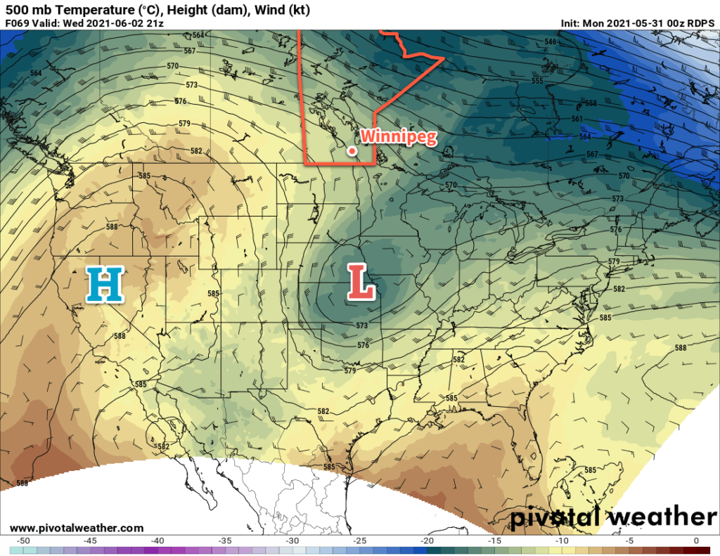
On Tuesday night, a low pressure system lifting out of Montana will support a strengthening flow overrunning the warm front. The combination of lift and destabilization will produce thunderstorms over the northern Plains that will push across southeastern Saskatchewan and southern Manitoba into Wednesday. There will be enough instability and organization in the environment for the risk of severe thunderstorms. The primary threats overnight would be hail and wind. There is also a chance that the thunderstorms may organize into a squall line. If they did so, it could bring damaging winds to portions of southeastern Saskatchewan and/or southern Manitoba overnight.

Temperatures will head to a low near 18 °C on Tuesday night.

RDPS 2m Dew Point Forecast valid 21Z Wednesday June 9, 2021
Humid conditions will spread across southern Manitoba on Wednesday.

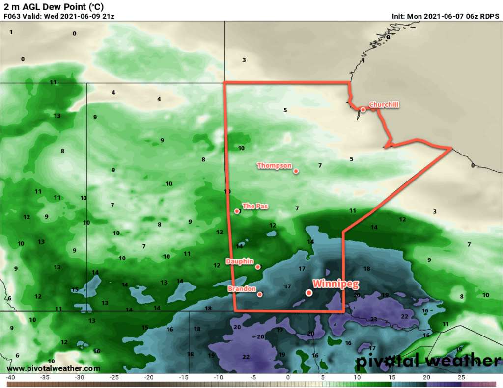
On Wednesday, the warm front will lift northwards into southern Manitoba. This will combine with an upper level disturbance moving into the region to support scattered showers and/or thunderstorms. The cloud cover will keep temperatures cooler than Tuesday, but it will become substantially more humid. Although the high will be around 26 °C, dew points will climb into the 18–20 °C range and make it feel closer to the low 30s. The unsettled weather will push off to the northeast for Wednesday night with a low near 17 °C.

Long Range Outlook

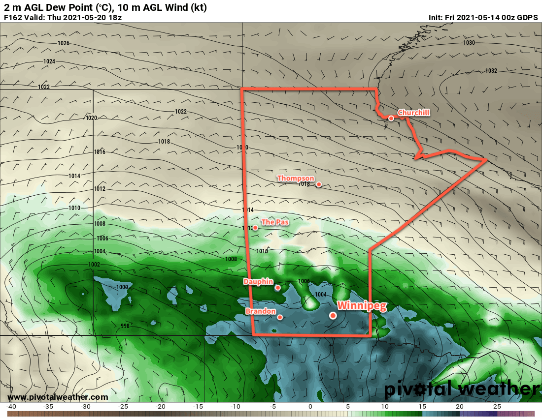
The warm and humid weather will stick around for the rest of the work week with highs in the mid-20s and dew points hovering in the upper teens. The sun should return for Thursday afternoon, then another passing low will bring a chance showers and thunderstorms to the region on Friday. A cold front will sweep through after that, ushering in drier conditions for the weekend. Temperatures will stay warm into next week with highs in the 25–30 °C range.

Today’s seasonal daytime high in Winnipeg is 23 °C while the seasonal overnight low is 10 °C.

Heading Into A Heat Wave

Winnipeg will see temperatures soar this week as scorching heat builds into the region.

Winnipeg will see plenty of sunshine over the next few days as an upper ridge builds into western Canada. On Tuesday, a weak low moving through southern Manitoba will bring a few more clouds into the region. As it slumps southwards, it will bring a chance for scattered showers or thunderstorms. The support for thunderstorms will be weak — bulk shear will sit at 20–30 knots and try to offset the limited energy — but there will likely be enough forcing to support a few. Skies will clear out again for Wednesday.

RDPS 500mb Wind and Temperature Forecast valid 21Z Wednesday June 2, 2021
A potent upper ridge will build out of the western United States into the Canadian Prairies this week.

The big story will be the building heat this week. As the upper ridge strengthens over the Prairies, Winnipeg will see daytime highs rise from the low 20s today to around 30 °C by Wednesday. Overnight lows will follow suit increasing into the upper teens by mid-week.

Long Range Outlook

The heat will continue to build through the latter half of the week. Daytime highs should peak on Friday in the mid- to upper 30’s as overnight lows stay in the upper teens. Fortunately, dew points are forecast to stay in the low to mid-teens, so humidex values won’t be a significant component of the heat wave. The hot weather will continue into the weekend, then begin to ease as unsettled conditions develop on Sunday into next week.

Today’s seasonal daytime high in Winnipeg is 22 °C while the seasonal overnight low is 8 °C.

Warm Holiday Monday Followed by Mid-Week Cool-Down

Winnipeg will see a beautiful holiday Monday followed by a quick reminder that colder weather lurks not so far away.

Winnipeg will see temperatures climb today as a push of warmer air moves through the region. It will start off this morning with some cloud and a chance of showers as an occluding trowal lifts through the region. Moderate south-southwest winds of 30–40 km/h will persist through the day as skies clear behind a weak cold front. The region will see markedly warmer temperatures than yesterday with a high near 25 °C. Winds will ease in the evening as temperatures head to a low near 14 °C under mainly clear skies.

RDPS 2m Temperature Forecast valid 21Z Monday May 24, 2021
Southern Manitoba will see a mild temperatures for the holiday Monday with highs in the mid-20s.

A low pressure system will push eastwards out of Saskatchewan across Manitoba on Tuesday. As it moves into the region, Winnipeg will see increasing cloud and southwest winds near 30 km/h. Temperatures will climb to a high near 19 °C by late in the morning. A cold front will sweep through the Red River Valley as the low passes in the afternoon. This will bring scattered showers into the region along with moderate northwest winds up to 40 gusting 60 km/h. The chance for showers will taper off into the evening, but the moderate northerly winds will continue for much of the night. A large Arctic ridge will push into the region behind the cold front, sending Winnipeg’s low close to the freezing mark by Wednesday morning.

That Arctic high will lay across the entirety of Manitoba on Wednesday, bringing a cool day to the region. Winnipeg will see a high only around 11 °C with northerly winds near 20 km/h. With that late-May sunshine, a sunny start to the day will likely see some afternoon cumulus clouds despite the cool temperatures. Skies will stay mainly clear on Wednesday night with light winds. Temperatures will likely dip below freezing in outlying areas, and drop close to freezing closer to the city centre.

RDPS 2m Temperature Forecast valid 12Z Thursday May 27, 2021
…and the mighty have fallen; much colder temperatures will arrive mid-week. Much of southern Manitoba will see a hard freeze or risk of frost Tuesday night and Wednesday night.

This Arctic high will bring a risk of frost to much of southern Manitoba on both Tuesday night and Wednesday night. Areas north of the Trans-Canada highway as well as southwestern Manitoba will likely see a hard freeze. For the Red River Valley, frost is more likely in rural areas than in the City of Winnipeg. While it’s less likely to freeze in the city centre, open and outlying areas of the city will see a higher risk of frost both nights. Temperatures are not forecast to drop much below zero in the Red River Valley, and will recover quickly above freezing both Wednesday and Thursday morning.

Long Range Outlook

Temperatures will recover through the rest of the week back towards seasonal values with partly cloudy skies. A weak low passing on Saturday will bring more cloud and a chance of showers to the region. After that, it looks like a nice stretch of seasonal temperatures with variable cloudiness will start off the next week.

Today’s seasonal daytime high in Winnipeg is 21 °C while the seasonal overnight low is 7 °C.

Warm And Occasionally Unsettled Weather Continues

Warm and mostly dry weather will continue in Winnipeg through the weekend.

Another in a series of weak disturbances will move through southern Manitoba today. It will bring mixed skies to the region with another chance of scattered showers this afternoon. Temperatures will be mild with a high near 23 °C and winds will be generally light. With the dry conditions, any showers will be capable of producing locally gusty winds up into the 50–70 km/h range. The cloud cover will break up tonight with temperatures heading to a low near 9 °C.

On Saturday, the region will see light winds with partly cloudy skies. Temperatures will head to a high near 23 °C again. By the evening, an organized low crossing the northern Prairies will push a warm front eastwards through the region. As it passes, it will bring a chance of showers to the region. The rest of the night should see partly cloudy skies and a low near 12 °C. Southerly winds will strengthen to around 20 km/h overnight.

RDPS 2m Temperature Forecast valid 21Z Sunday May 16, 2021
Daytime highs of 25–30 °C will develop over southern Manitoba on Sunday.

Sunday will bring the heat to southern Manitoba. Well into the warm sector of the northern Manitoba low, breezy southwest winds of 30–40 km/h will send highs into the upper 20s. A trough will slump southwards into the region through the afternoon. It will bring a chance of showers with it, and behind it winds should diminish a bit and turn westerly. The region will see a few clouds Sunday night with diminishing winds and a low near 12 °C.

Long Range Outlook

Another organized low will start moving out of central Alberta on Monday, bringing a renewed push of warmer air into southern Manitoba. Temperatures will be very warm through the first half of the week.

By mid-week, the persistent southerly flow will bring a pool of Gulf of Mexico humidity into the northern Plains of the United States, potentially into southern Manitoba as well. As this moisture approaches, forecasts show a deep upper trough moving into western North America. These two features will combine to bring more humid and unsettled conditions to southern Manitoba in the second half of the week.

GDPS 2m Dew Point Forecast valid 18Z Thursday May 20, 2021
Forecasts show a substantial increase of humidity in the latter half of next week with dew points climbing into the upper teens.

The potential exists for significant rainfall, which would be welcome relief for the drought conditions. This unsettled period could also bring the first well-organized thunderstorm risk to the region, but if the forcing is too strong, it will favour broad areas of showers instead.

So after another warm and mostly dry 5 days, the region should see a shift into a more humid and unsettled pattern.

Today’s seasonal daytime high in Winnipeg is 20 °C while the seasonal overnight low is 5 °C.