Cloudy, Cool and Unsettled Week Ahead for Winnipeg

A series of slow-moving low pressure systems will move through southern Manitoba this week, bringing cloudy, cool and unsettled conditions to the region.

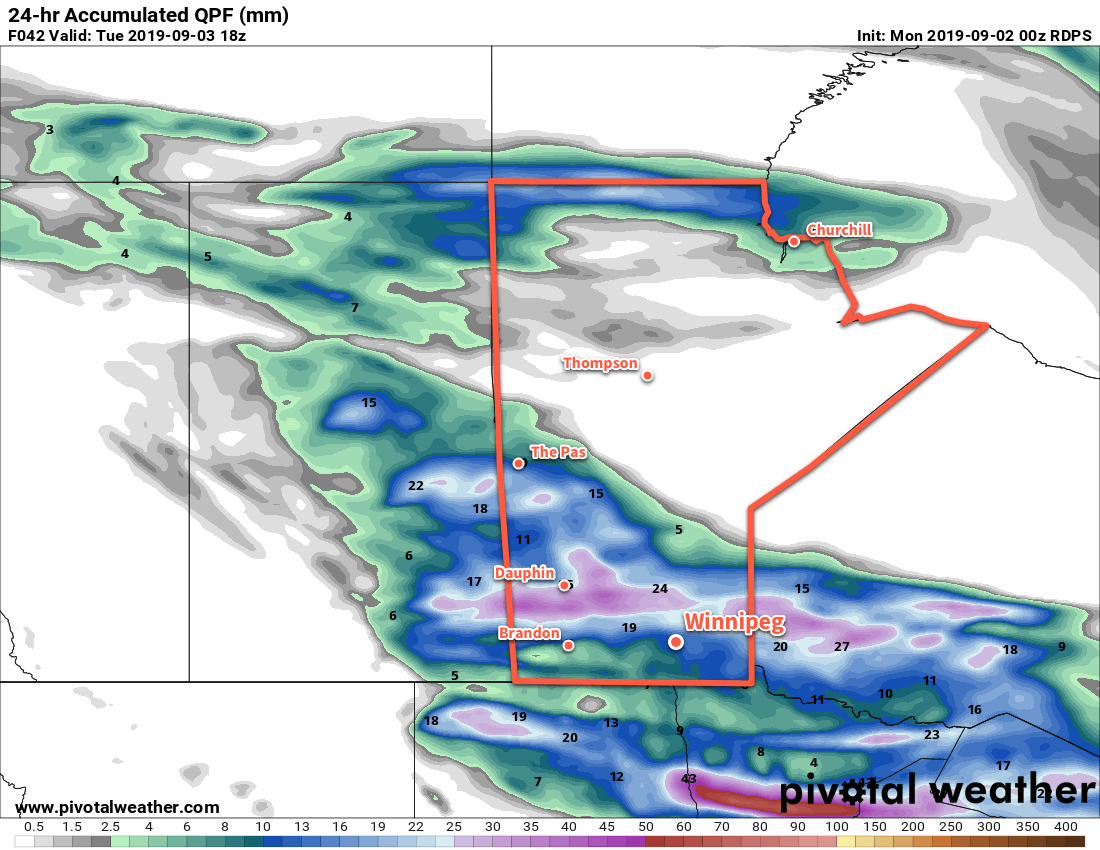
The first disturbance this week will move into the Dakotas today, spreading cloud cover and rain northwards. Winnipeg may see a bit of sun this morning, but skies will cloud over relatively quickly today. Rain will begin spreading north through the Red River Valley in the afternoon, reaching Winnipeg by the evening. Temperatures won’t be too bad with a high near 17°C, but that will likely be earlier in the day before the clouds thicken up. Winds will be noticeable today, though, picking up out of the east into the 30 gusting 50 km/h range.

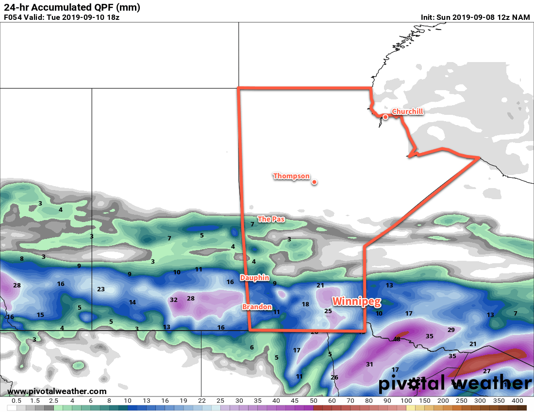
The rain will persist through the night as winds gradually turn northeast and weaken. Rainfall amounts may be variable, generally in the 10 to 20 mm range. If a few embedded lines of convection develop, then localized amounts could increase into the 20 to 30 mm range. The only potential trouble spot in the forecast is the chance of a slight break in the rain developing over the Red River Valley between hang-back rain over southwest Manitoba and the low-supported rain spreading northeast. If this happens, a swath of the region will see little rain, but we’ll just have to watch as things evolve through the afternoon. Temperatures will dip to a low near 12°C.

Some forecast models suggest rainfall totals of 20 to 30 mm from midday today to midday Tuesady, but widespread totals will likely be lower than that.

The rain will ease early Tuesday morning, but chances for a few patches of light rain or drizzle will persist. Skies will stay cloudy with northerly winds of 15 to 20 km/h persisting through the day; with a high of just 14°C it will certainly feel fall-like out there. The chance for precipitation will taper off for the night, leaving Winnipeg with cloudy skies and a low near 9°C.

Wednesday will bring more cloud to the region with winds picking up out of the east to around 20 km/h. Temperatures will climb to a high near 16°C and despite the cloud it should stay dry through the day. The chance of rain will increase on Wednesday night as the next disturbance begins lifting towards the region from Wyoming. Temperatures will dip to a low near 11°C on Wednesday night.

Long Range Outlook

Thursday will bring more rain to Southern Manitoba as more energetic system pushes towards the region. As a result, there may be a few embedded thunderstorms move through. The region may see more rain with this system as well, possibly in the 20 to 40 mm range. There’s a good chance that some light showers will persist into Friday, then sunshine and near-seasonal temperatures return for the weekend.

Today’s seasonal daytime high in Winnipeg is 20°C while the seasonal overnight low is 7°C.

Rainy Monday Night Followed By Gradual Improvement

More rain is on the way for Winnipeg tonight, then the sun returns mid-week for several pleasant days.

A low pressure system pushing eastwards across the Prairies will bring more rain to Winnipeg later today. After a sunny start to the day, clouds will push back into the region this afternoon. Temperatures should reach a high near 19°C, but southeasterly winds of 20 to 30 km/h will make it feel cooler than that. Showers will spread into the region for the evening hours and persist for much of the night. There may even be a chance for a few embedded thunderstorms through the evening hours.1 The showers will gradually taper off overnight behind the low. The wind will ease in the evening, then pick up out of the northwest to around 30 km/h late overnight. Temperatures will dip to a low near 11°C.

A broad swath of rain and showers will spread across southern Manitoba on Monday.

Tuesday will start off with cloudy skies and a chance of some lake-effect showers drifting southeastwards of both Lake Manitoba and Lake Winnipeg. Skies will stay mostly cloudy for much of the day, but a few sunny breaks may develop late in the afternoon. The cloud cover and northwest winds will keep things cool; Winnipeg will see a high only near 15°C. The winds will ease in the evening with clearing skies; Winnipeg should see a low near 6 or 7°C.

On Wednesday, a southerly return flow combined with sunshine will help temperatures recover back to seasonal values. The city will see a high near 22°C with southwest winds around 15 km/h. The next disturbance crossing the Prairies will push more cloud back into the region through the afternoon. Skies should clear back out overnight with a light south wind continuing. Temperatures will dip to a low near 11°C.

Long Range Outlook

The remainder of the work week is looking nice with highs in the low 20s or upper teens and variable cloudiness. Cooler temperatures will return for the weekend, but the region should still see a fair amount of sunshine. Unsettled conditions are forecast to return to start off next week.

Today’s seasonal daytime high in Winnipeg is 21°C while the seasonal overnight low is 9°C.

  1. No severe weather is expected.

Cool, Unsettled Conditions Return For The Weekend

Winnipeg will see cloudy, cool weather return for the weekend with what looks like a good chance for some rain on Saturday.

Before the gloomier weather arrives, though, Winnipeg will get to enjoy plenty of sunshine today. A ridge of high pressure moving through will keep skies clear with northwest winds to around 20 km/h. Temperatures will climb to a seasonal high of 22°C this afternoon. Cloud cover will begin pushing in overnight with temperatures dipping to a low near 10°C.

Cloudy skies will remain in place through the day on Saturday as an upper-level disturbance crosses the region. An initial batch of showers will cross southern Manitoba through the day, likely impacting Winnipeg and areas south. In the evening, a secondary area of developing showers will likely impact Winnipeg and areas north. The cloudy skies and precipitation will keep things cool with a high in Winnipeg near 16°C. On the upside (perhaps?), winds will be light through the day. The city will see a low near 11°C on Saturday night.

Much of southern Manitoba will likely see showers this weekend as several disturbances move across the region.

Skies in Winnipeg will stay mostly cloudy on Sunday. Conditions should stay dry through the morning, allowing temperatures to climb to a high near 19°C. The chance of showers will redevelop mid-afternoon as another disturbance moves through the region. The showers are will move off to the southeast on Sunday night with temperatures dipping to a low near 8°C.

Long Range Outlook

More unsettled conditions are forecast for Monday with another chance of showers expected in the Red River Valley. The cloud cover is forecast to break up for Tuesday, leaving the city with partly cloudy skies for much of the remainder of the week. Temperatures are forecast to remain steady with highs in the upper teens and lows in the upper single digits.

Today’s seasonal daytime high in Winnipeg is 22°C while the seasonal overnight low is 9°C.

Seasonably Cool Weather Settles Over Winnipeg

Winnipeg will see cooler daytime highs through the rest of the week with another chance of showers on Wednesday night.

The sun will make a reappearance in Winnipeg today after a rather unsettled start to the week. West-northwest winds near 30 km/h will continue through the day with a high near 21°C. Late in the day, cloud cover will begin to increase as a low pressure system moves in from the northwest. As it moves through tonight, Winnipeg may see a few more rain showers but most of this system’s precipitation is forecast to remain north across the Interlake. The cloud will help keep things a tad warmer through the night; Winnipeg should see a low near 12°C.

The cloud cover will gradually break up on Thursday morning, leaving the city with mixed skies that clear out for the afternoon. The wind will continue out of the northwest near 30 gusting 50 km/h, tapping into cooler Arctic air. Winnipeg should see a high near 20°C on Thursday. A ridge of high pressure moving in on Thursday night will ease the winds but also send temperatures plummeting to a low near 6°C.

A band of showers will move across southern Manitoba on Wednesday night.

The city will continue to see mainly clear skies on Friday with light northwest winds. Temperatures will climb to a high near 21°C. A few clouds will move on on Friday night as temperatures head to a low near 12°C.

Long Range Outlook

More cloud will move into the region this weekend as another low pressure system begins working across the Prairies. Several chances for showers will likely develop on Saturday through Tuesday as this disturbance works through the region. Temperatures will continue with highs mainly in the low 20s and overnight lows in the upper single digits or low teens.

Today’s seasonal daytime high in Winnipeg is 23°C while the seasonal overnight low is 10°C.