Warmer Weather Returns, But More Chances For Rain Ahead

Temperatures will rebound back above seasonal values today as southwesterly winds aloft bring warmer air back to the region, but another major low pressure system is heading into the Prairies that will spread rain across southern Manitoba on Tuesday.

Today will be a beautiful day in Winnipeg after a bit of a dreary weekend with plenty of sunshine and a high near 19°C. Winds will be light out of the south to southeast. Through the afternoon hours, a bit of cloud will move through the region, bringing mixed skies to Winnipeg and cloudier conditions to the southeast. Some areas may even see some light showers, but that looks like it will be more confined towards the Whiteshell and Sprague regions. Temperatures will then head to a low near 10°C tonight under a few clouds.

RDPS 2m Temperature Forecast valid 21Z Monday September 18, 2017
Daytime highs will sit in the upper teens across much of Southern Manitoba on Monday.

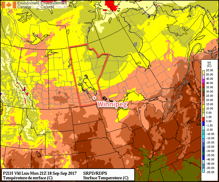
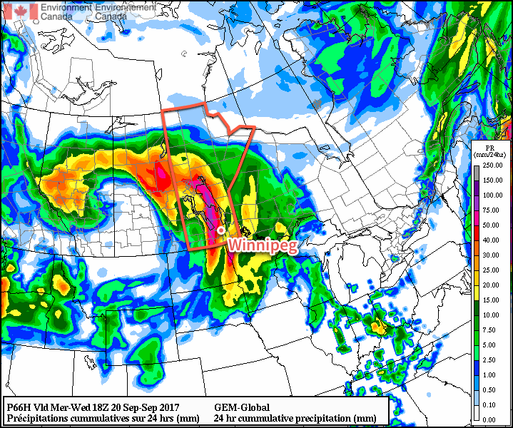
Tuesday will bring the arrival of the next significant low pressure system in Manitoba. Temperatures will continue to be relatively mild with highs near 19°C again, but winds will be breezy picking up out of the southeast to 30-40 km/h. Cloud will spread into the region early in the day, with rain blossoming1 mid-day over southwestern Manitoba and mid- to late-afternoon over the Red River Valley. The winds will then taper off in the evening, with the bulk of the rain pushing off east of the Red River around midnight. Temperatures will dip to a low near 11°C.

GDPS 24hr QPF Forecast valid 18Z Wednesday September 20, 2017
The GDPS suggests very high rainfall totals possible west of Winnipeg on Tuesday afternoon and evening, but the overall rainfall totals will likely fall into the 10-25mm range over the Red River Valley.

Wednesday will start off with a slight chance of a few lingering showers, but will then transition towards drying out and clearing as the day progresses. Temperatures will be mild with highs near 20°C again with a bit of a breeze out of the west to southwest at around 20-30 km/h. Expect a low near 11°C on Wednesday night under mainly clear skies.

Long Range

Thursday looks to be another nice day with above-seasonal highs near the 20°C mark, but then another major low pressure system will track into the Northern Plains Thursday night through Friday, bringing another chance for rain alongside brisk northeasterly winds and cooler temperatures. Once it passes by Sunday, it appears that Winnipeg will then see a more extended period of near- to below-seasonal temperatures.

Winnipeg’s seasonal daytime high is currently 17°C while the seasonal overnight low is 5°C.

  1. There may even be a chance of seeing some thunderstorms!

Cool, Wet Weekend Ahead

A distinct chill will be in the air over the next few days as unseasonably cool temperatures move into Winnipeg and the Red River Valley alongside the first substantial rainfall in months.

As mentioned on Wednesday, a low pressure system will begin working its way into Manitoba today, bringing what will likely be the largest rainfall event of 2017 [thus far] to the city. The biggest change between our forecast on Wednesday and what is expected to happen today is the timing: the system’s arrival will be slightly delayed, beginning in the afternoon rather than the morning.

So, today will start off fairly cloudy skies, although a few sunny breaks are possible between now and this afternoon. As the low pressure system lifts northwards out of Nebraska into the Dakotas, cloud will thicken up over the Red River Valley with rain beginning this afternoon. The rain will become more intense into the evening with even a small chance for a crack of thunder or two. The heaviest rain should move out around midnight, with some showers or drizzle left behind.

Temperatures will be cool; expect a high near 14°C, but quickly drop to around 10 or 11°C when the rain begins. Expect a low near 8°C tonight. The winds will also be rather unpleasant, picking up out of the north-northeast to around 40-50 km/h this afternoon. The winds will persist into the evening, then diminish to 30 gusting 50 km/h overnight.

By the time the bulk of the rain pulls out of the region, Winnipeg and the Red River Valley will likely see between 20 and 40 mm, with the potential for a bit more or a bit less locally depending where exactly any heavier or lighter bands of rain set up.

RDPS 24hr. QPF valid 18Z Saturday September 16, 2017
The RDPS is suggests as much as 50-60mm of rain may be possible from Friday afternoon to midday Saturday over the Red River Valley

Saturday will bring very cool weather to the Red River Valley with daytime highs likely not even reaching 10°C. Stuck between the Friday night’s disturbance and another one that will move through Saturday evening, skies will remain cloudy with a continued chance of showers or drizzle. Winds will continue out of the north-northeast at 30 gusting 50 km/h for the day, but then diminish to calm in the evening.

As the next disturbance rolls by on Saturday evening, it will likely produce another batch of showers or rain over the Red River Valley, but amounts will be considerably less, with under 5 mm expected for most of the Red River Valley. Temperatures will drop to a low near 7°C.

And for Sunday, some morning cloud with the potential for showers or drizzle will begin moving out midday, bringing mixed to sunny skies back to Winnipeg for the afternoon. Expect a high near 15°C with winds picking up out of the west-southwest to around 30 km/h.

Long Range

The beginning of next week will start off sunny with temperatures returning to near-seasonal values for Monday and Tuesday. By Wednesday, however, another series of disturbances roll through the region, bringing what looks like another fairly good chance for more rain through the latter half of the week.

Winnipeg’s seasonal daytime high is currently 18°C while the seasonal overnight low is 6.

Slow Slide To Cooler & Rainy Weather

Winnipeg will see the weather slide from September Summer™ to seasonal to cool and rainy over the next few days as a developing storm system in the Northern Plains gets set to bring a major pattern shift to southern Manitoba.

Today will continue the September Summer™ for Winnipeg and the Red River Valley as daytime highs climb well above-seasonal into the mid-20s under nothing but sunshine. Winds will be fairly light today too at just 15-20 km/h, making for a gorgeous day. Some cloud cover will move through tonight as temperatures dip to a low near 13°C.

Warmer than seasonal daytime highs will continue for another day across southern Manitoba

Thursday will see the beginning of a major pattern change as a major low pressure system gradually organizes through the northern plains of the United States. As it does so, a northeast wind to 20-30 km/h will begin tapping cooler air from the central Prairies, returning near-seasonal temperatures back to Winnipeg and the Red River Valley. Skies will be mixed with increasing cloudiness overnight.

Friday’s dominant weather feature will be a trough of low pressure developing across central North Dakota into southeastern Manitoba in response to a low pressure system tracking into Nebraska out of Wyoming. This trough line will support the development of a large area of rain that will spread northeastwards from western North Dakota along the trough, likely arcing through southwest Manitoba and across the Red River Valley into the Whiteshell.

Rain will spread northeastwards out of Montana and western North Dakota on Friday morning

This feature has all indications that it will be a prolonged rainfall event, with rain beginning Friday morning and continuing into Saturday morning. Total rain will be variable and dependant on whether or not any embedded convection develops, but general amounts of 20-30 mm look quite likely. With all the rain, temperatures will be quite cool with highs well below-seasonal in the low teens.

Long Range

Unsettled weather will continue on Saturday with improvement on Sunday, but the chance for more rain will return on Sunday night into Monday morning. Temperatures will remain below-seasonal through the weekend.

Into next week, temperatures will return to near-seasonal values, but it looks like there will be multiple chances for rain as several disturbances cross the Prairies.

Winnipeg’s seasonal daytime high is currently 18°C while the seasonal overnight low is 6.

Cloudy, Cool Mid-Week Gives Way to Another Heat Wave

Temperatures will be well below-normal today as Winnipeg and the Red River Valley remain entrenched under a cool northeasterly flow behind yesterday’s low that moved through the region. Temperatures will rebound quickly, though, with well above-normal temperatures return for the end of the work week.

Today will see high temperatures some 10°C below typical seasonal as cool, cloudy weather hangs over the Red River Valley as northeasterly winds tap cooler air underneath a cold upper-level low crossing over the region. Skies will remain cloudy much of the day — there’s a slight chance we might see some sunny breaks late this afternoon — and there will be a chance for some light rain or drizzle, particularly in the morning hours. Temperatures will reach a high of only around 16°C1 with winds out of the northeast at 15-25 km/h.

Skies will begin to clear tonight as temperatures dip to a low near 11°C with light winds.

A cold low, shown here with closed height contours at the 700mb level, will move across southern Manitoba on Wednesday, keeping skies cloudy and temperatures cool.

Thursday will be a much nicer day as the remaining cloud cover clears out and temperatures climb to a high near 23°C under light winds. There may be some scattered clouds in the afternoon, but nothing that will spoil the sunshine. Expect clear skies on Thursday night as temperatures drop to a low near 13°C.

On Friday, the upper-level ridge that brought scorching hot weather to B.C. and the western Prairies last week begins building back into the region. Under sunny skies, temperatures in the Red River Valley will climb into the lower 30’s. Areas in the southwest corner of the province will be even hotter, with high temperatures climbing into the mid- to upper-thirties. Southerly winds at 20-30 km/h will be in place as a low pressure system slumps towards the region from the northwest. These winds will draw humid conditions northwards; by the end of Friday dew point values will climb into the low 20’s, making it feel positively muggy out there.

Very warm temperatures will build across the entirety of the Southern Prairies on Friday with highs in the 30’s.

Friday night will continue to be warm with lows dropping only to around 18°C.

Long Range

Northerly winds will move into the region on Saturday, flushing the humidity southwards and making for more comfortable conditions. Daytime highs will still remain in the upper 20’s or low 30’s throughout the weekend under mainly sunny skies. With the warm air still in place, overnight lows will still be quite warm, likely bottoming out in the upper teens.

The hot weather continues next week, but there are signs that there may be some unsettled weather to begin the week before things settle down again. No significant widespread rainfall is expected in the next week.

Winnipeg’s seasonal daytime high is currently 26°C while the seasonal overnight low is 13°C.


  1. Although if more clearing were to develop than expected, temperatures would quickly reach closer to 18 or 19°C.