Warmer Weather Returns Alongside Chance of Rain

With the ridge of high pressure that brought the decidedly fall-like temperatures now moving off to the southeast, temperatures will begin to warm and head back towards seasonal. Although today will bring plenty of sun to the region, a low pressure system is heading our way from Idaho and will bring cloud and a renewed chance for rain for Thursday night and Friday.

A beautiful sunny day, hopefully unimpeded by a rogue cloud bank that should remain in North Dakota, will be in place through Winnipeg & the Red River Valley today. Our very cool start to the day will be quickly forgotten as temperatures climb to around the 20°C mark this afternoon with a southerly wind near 20 km/h. Tonight will be milder than last night with a low near 10°C.

Thursday will bring increasing cloudiness to the region ahead of an incoming low pressure system. A southerly wind once again near 20 km/h will continue to draw mild air northwards and help temperatures climb to a high near 22°C. By evening, an area of rain will likely push into the region from the southwest, with the wet weather continuing overnight as temperatures fall to a low near 14°C.

The GDPS is forecasting a swath of 20-30mm of rain through Winnipeg on Thursday night and Friday, however some other models suggest much less rain and the main swath pushed a bit further southeast.

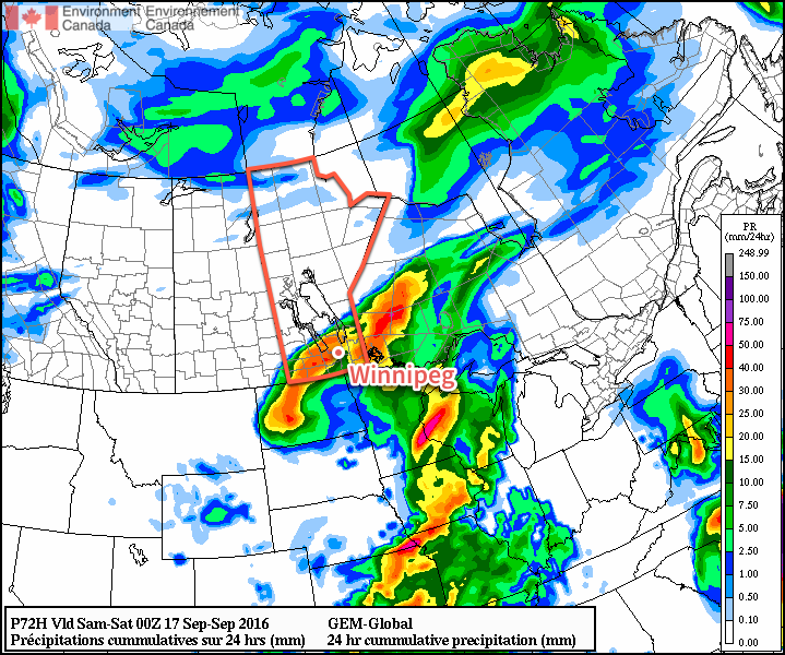
Friday will be mainly cloudy with a continued chance of rain through Winnipeg and the Red River Valley eastwards to the Ontario border. Winds will shift out of the north as the low pressure system moves into Ontario which will combine with the extensive cloud cover to keep our daytime high to just 16 or 17°C. As skies clear on Friday night, temperatures will dip to a cool low near 7°C.

Long Range

The weekend is looking quite pleasant with dry weather, plenty of sunshine and daytime highs returning to the low- to mid-20’s.

Winnipeg’s seasonal daytime high is currently 18°C while the seasonal overnight low is 6°C.

Unsettled Weather to Start The Week

A series of low pressure systems will bring two rounds of unsettled weather to the province before calmer weather moves in for the second half of the week.

Today will be a continuation of the humid weather that moved into the region on the weekend with muggy dewpoint values near 18°C persisting as temperatures climb to a high near 27°C. Skies will remain mostly cloudy through the day, although a few sunny breaks might be seen.

The main weather focus for the day will be thunderstorm potential. Any remaining thunderstorm activity from overnight will clear out this morning, but it won't be much of a reprieve before a new batch of thunderstorms develop along a slow-moving cold front sweeping across the Red River Valley. There will be a slight risk of severe thunderstorms with today's activity; primary threats will be large hail and torrential downpours, but a smaller threat of damaging winds also exists.

The RDPS hints at significant rainfall accumulations of ≥ 40-50mm possible after today's thunderstorms.
The RDPS hints at significant rainfall accumulations of ≥ 40-50mm possible after today’s thunderstorms.

The thunderstorm activity will clear out through the afternoon and evening hours from northwest to southeast across the Red River Valley & SE Manitoba. Skies will clear out, temperatures will drop to a low near 16°C, and the humidity will begin to be flushed out overnight.

Tuesday will be a beautiful day throughout the Red River Valley as temperatures climb to a high near 29°C. Winds will be breezy out of the west at 20-30 km/h. Expect a low near 16°C on Tuesday night.

The weather on Wednesday will be under the influence of the next low pressure system moving into the region. Through the day, showers will begin spreading into Southern Manitoba beginning in the southwest corner of the province in the morning, spreading into the Red River Valley through the afternoon, and then onwards towards the Ontario border in the evening.

There's still quite a bit of uncertainty on the main precipitation swath, so we'll be keeping an eye on this one as it develops. That said, best indications are for the heaviest accumulations over Parkland Manitoba with up to 25-30 mm of rain, and then lesser amounts south and eastwards as the rainfall takes on a more transient nature.

Long Range

The remainder of the week and heading through the weekend looks quite dry with mostly sunny skies and daytime highs in the mid-20's, so after the system clears out on Thursday morning, there should have plenty of pleasant days ahead!

Winnipeg’s seasonal daytime high is currently 26°C while the seasonal overnight low is 13°C.

Heat Breaks with Soggy Saturday

The heat seen over southern Manitoba over the past week will be in place for just one more day before a low pressure system moves through the region on Saturday, bringing soggy weather and cooler temperatures.

Another hot day is on the way for Winnipeg, but humidity will continue to decrease slightly towards more comfortable levels. Winnipeg & area will see plenty of sunshine today with just a few puffs of cloud possible in the afternoon. Winds will be fairly light out of the west-northwest at 15-25 km/h. Temperatures will climb to a high near 28°C. Tonight will bring increasing cloud and light winds as temperatures dip to around 18°C.

A low pressure system will be pushing northeastwards out of Saskatchewan & Montana on Friday night.

Saturday will be an unsettled day as a low pressure system moves through the province. The daytime high will be in the mid-20’s with winds picking up out of the south to 20-30km/h in the morning.

There will be rain on Saturday, however at this point, there’s still some uncertainty on exactly where precipitation will fall. Indications are that amounts will generally be 5-15 mm, however convective elements may produce rainfall amounts up to 30-50 mm in thunderstorm activity.

One potential outcome of Saturday shows two main areas of convective rainfall with up to 50 mm of rain.

Ultimately we’ll simply have to wait and see how things shape up and what the nature is of the precipitation that develops through Montana and Saskatchewan tonight. We’ll provide updates in the comments below.

Much of the rain will taper off on Saturday evening, leaving us with fairly cloudy skies and a low that falls to around 16°C by Sunday morning.

Sunday will be a bit of a mixed bag. Expect mixed skies and a high near 26°C, however winds will be breezy, peaking out of the northwest at around 40 km/h and we’ll see just a slight chance of some scattered showers. Skies should clear for Sunday night as temperatures head to a low near 16°C.

Long Range

The start of next week looks fairly pleasant with sunny to mixed skies and daytime highs in the mid- to upper-20s. It looks like it will be fairly dry with a ridge of high pressure deflecting things south of the Red River Valley, but that will be sensitive to the exact location that this feature sets up.

Winnipeg’s seasonal daytime high is currently 26°C while the seasonal overnight low is 13°C.

Fall-Like Wednesday Leads to Drier, Warmer Weather

Southern Manitoba will be under the influence of a major low pressure system for one more day, bringing gusty winds and more rain shower activity, before drier conditions begin moving in through the remainder of the week.

Winnipeg & the Red River Valley will continue to be under the influence of a major low pressure system currently located over eastern Manitoba for one more day. Today will see cloudy skies and on and off showers through the day across the region, although they will likely be more numerous through the morning hours. Winds will be quite breezy out of the west to northwest at 30-40 km/h with gusts up to around the 60 km/h mark, and it may even feel more like late-summer thanks to a below-seasonal high temperature of just 18°C.

The rain shower activity will taper off through the late afternoon into the evening hours, leaving mainly cloudy skies in Winnipeg as temperatures head to an overnight low near 13°C. The winds will continue breezy at around 30 km/h.

Around 5mm of rain can be expected from showers across much of Southern Manitoba today.

Thursday will bring mainly cloudy skies, although a bit of sun may be possible late in the day. Winds will be lighter than Wednesday at around 30 km/h out of the northwest. Daytime highs will be a bit warmer throughout the Red River Valley at around 20 or 21°C. A lingering trough may result in a few afternoon showers near the U.S. border and extending back into southwestern Manitoba.

Skies will continue to clear Thursday night as temperatures dip to around 12°C.

Friday will be a pleasant day with light winds, plenty of sun and a high near 23°C.

Winnipeg’s seasonal daytime high is currently 26°C while the seasonal overnight low is 13°C.