Anyone looking for a good long stretch of hot, dry weather really should consider broadening their horizons because generally unsettled weather continues throughout Southern Manitoba right through the coming weekend.
Today will be the most pleasant and "summer-like" day of the coming few as the sun makes a prominent showing with temperatures climbing into the mid-20's for a daytime high. While some showers or thunderstorms are possible over southwestern Manitoba today, Winnipeg & the Red River Valley should see just a few clouds with no precipitation expected.
Tonight will continue to be fairly pleasant with a low near 13°C.
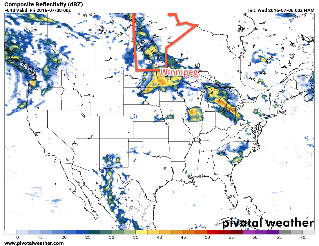
Thursday will bring unsettled weather back to Winnipeg as an upper low moves into southern Manitoba. Increasing cloudiness and showers will spread from the southwestern Red River Valley to the northeast through the morning, and then the unsettled conditions will persist through the afternoon. At this point no thunderstorm activity is expected. Temperatures will reach a high near 23°C and then head to a low near 14°C on Thursday night with a continuing chance of showers.
Several models are showing an area of rain or showers moving through the Red River Valley on Thursday afternoon.
Friday will continue with fairly cloudy skies and a slight chance of more light shower activity. Some sunny breaks are possible in the afternoon as the temperature climbs to a high near 23 or 24°C. Temperatures will drop to around 14°C with clearing skies.
Hot, Unsettled & Increasingly Humid This Weekend
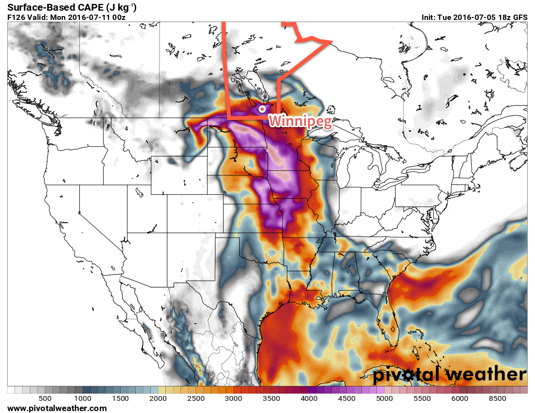
The weekend weather will be dominated by a developing trough of low pressure through the western and central Prairies that will draw humid air northwards from the Central Plains of the United States and bring with it the potential for multiple days of thunderstorm potential. Early indications are that severe thunderstorms will certainly be possible on both Saturday and Sunday. Highs will be in the upper 20's with Sunday in particular beginning to feel very muggy.
The GFS is forecsting potent SBCAPE values in excess of 4,000 J/kg by Sunday evening.
With the Winnipeg Folk Festival starting off this weekend, we'll be sure to keep a close eye on this system as it develops. Early indications are that the days will be fairly pleasant with more of a chance for thunderstorms through the overnight periods both Saturday night and Sunday night. By Sunday, there may be a significant severe threat with any thunderstorms due to the sheer amount of instability that is forecast to be in place over the region. We'll have a closer look at the weekend forecast on Friday morning.
Winnipeg’s seasonal daytime high is currently 26°C while the seasonal overnight low is 13°C.
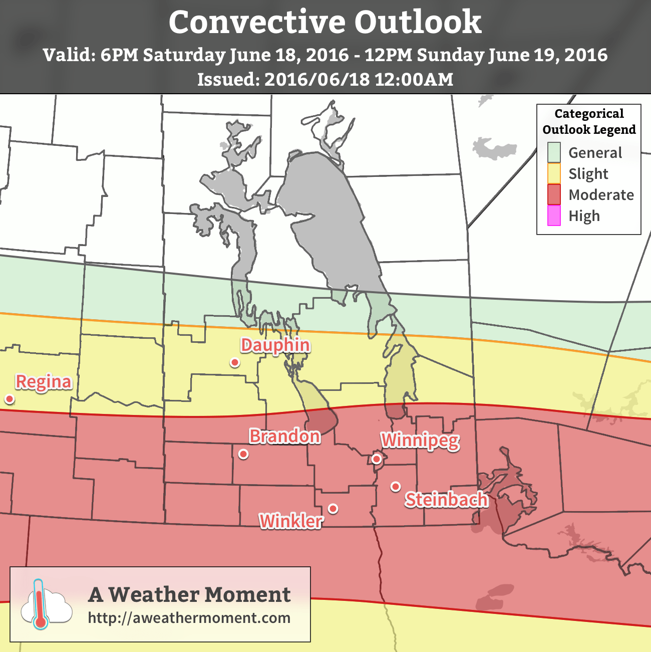
Sunday, June 19th marks both Father’s Day as well as the Manitoba Marathon, and unfortunately it appears that the unsettled weather we talked about in Friday’s post has the potential to bring a significant threat of severe thunderstorms to the region.
AWM Convective Outlook for June 18/19, 2016
The Short Version
Severe thunderstorms are possible early Sunday morning, however that threat will be conditional on the expected development of thunderstorms in Saskatchewan on Saturday night.
The current expectation is that an area of thunderstorms will develop over Saskatchewan Saturday night, expanding in coverage and accelerating eastwards through the overnight period. This area of convection will then move through the Red River Valley with a primary threat of severe and damaging winds as well as large hail and torrential rain capable of producing flash flooding.
Thunderstorm Threat Outlook for Sunday June 19, 2016
Threat Type
Threat Level
Details
Rain
Moderate
Torrential rainfall possible with flash flooding.
Hail
Moderate
2-4cm hail possible.
Wind
Moderate
Strong wind gusts in excess of 100 km/h likely
Tornado
Low
No tornado activity expected.
The thunderstorm activity is expected to occur between 4:00AM and 9:00AM, with the primary threat period between 5:00AM and 7:00AM. The timing may adjust depending on the exact speed of the system, but overall this is expected to be a morning event.
Forecast for the morning of June 19, 2016
6AM
8AM
10AM
12PM
17°C
19°C
21°C
23°C
Thunderstorms likely
Thunderstorm activity diminishes
Slight chance of showers
Partly cloudy
Alongside the thunderstorms, conditions will get notably more humid as the morning progresses.[1] By the time any thunderstorm or rain showers taper off, things will feel fairly sticky. Temperatures will start around the 16-17°C mark in the morning, climbing to around 23°C by noon, and then on to a high near 27°C in the afternoon. Winds will be fairly light until mid-afternoon when they pick up from the west to around 20-30 km/h, ushering in drier air and providing some relief from humidity.
The Details
The potent thunderstorm potential for Saturday night and Sunday morning across the southern Prairies will be the result of a potent shortwave that ejects northeastwards out of Montana on Saturday and then rides eastwards along the international border. This will spawn a surface low with cold front draped southwards as cooler air builds in behind the shortwave and warm front extending eastwards across the northern portions of the Northern Great Plains. The surface low will then slide eastwards, gradually lifting the warm front northwards as it goes.
This shortwave will [likely] initiate an area of convection over southwestern Saskatchewan that will track eastwards along with the shortwave. The orientation of the warm front will provide plenty of support for the convection with shear profiles that indicate the likely development of a MCS[2] containing bow echoes.
Going over the MIST ingredients:
Moisture: Dewpoint values near 18°C will be ingested into the convection on Saturday night. This will provide substantial energy for the thunderstorms to work with. Additionally, the high moisture content of the air being ingested will increase PWAT[3] values to over 50 mm, making very intense rainfall likely with any thunderstorms that develop.
Instability: Steep mid-level lapse rates will combine with the warm and humid air of the nocturnal inflow to produce MUCAPE values in excess of 2000 J/kg.
Shear: 55-65 kt of bulk shear coupled with veering profiles within the convection will support the development of strong, organized thunderstorms.
Trigger: Shortwave-induced mid-level destabilization coupled with the development of a strong LLJ.
For these parameters, the primary concerns will be hail and rain, however should the storms be able to break through the inversion, wind will rapidly become a significant threat as gusts in excess of 100 km/h will be possible.
The steep mid-level lapse rates combined with high MUCAPE values will produce a moderate hail threat with hail between 2-4 cm in diameter possible. The heightened PWAT values make torrential rain likely with these storms, which can result in rapid accumulations and flash flooding. The strong winds & shear profiles of the storm environment make damaging wind gusts possible. Justification for the strong winds despite the nocturnal part of the convection will be the intense storm-relative winds that will be associated with this quickly-moving system. The SR-inflow will likely be strong enough lift the low-level air mass wholesale into the storm, resulting in a surface-based or near-surface-based thunderstorm.
Summary
Father’s Day of 2016, and the Manitoba Marathon, face the potential of being remembered for severe thunderstorms if current guidance continues painting the picture it does. Thunderstorm potential is conditional on nocturnal convection developing on Saturday night in Saskatchewan, but if it does, there is a significant threat of severe thunderstorms over Southern Manitoba on Sunday morning.
The timing for the primary severe thunderstorm threat will be in the early morning, buffering the starting time for the marathon, with much of the thunderstorm activity expected to be out of the region by 10-11AM. In the wake of this system will be a warm day that will feel fairly humid until westerly winds kick in mid-afternoon, pushing out the humidity and drawing in drier, slightly cooler air for the start of next week.
Dewpoint temperatures are expected to rise from 12-13°C early in the morning to around 19°C by mid-morning. ↩
This week will get off to a great start, with warm temperatures and sunny skies. However, more rain is on the way Tuesday night as the next low pressure system moves into the region.
Warm weather is expected in southern Manitoba today
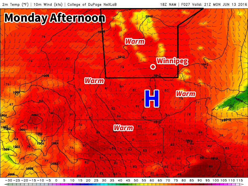
The Week
Today will be a great day in southern Manitoba. High temperatures in the mid to upper twenties are expected with sunny skies. Winds will be light from the west. Today may end up being one of the nicer days this week, so enjoy it!
Tuesday will see temperatures in the mid twenties, but with increasing cloudiness through the day as a low pressure system begins moving into the region. Winds will be breezy out of the south-east at 20 km/h gusting to 40 km/h ahead of this system. Rain is expected to move into southern Manitoba on Tuesday night with this next system.
Wednesday will see rain ending from the aforementioned low pressure system. At this potential rainfall accumulations remain uncertain, so check back tomorrow for more details. Once the rain ends skies will remain mainly cloudy with temperatures in the upper teens. Winds will be from the north at 20-30 km/h.
Long Range
The long range forecast shows warmer weather returning late this week. Models are also hinting at our next risk of thunderstorms developing on Thursday and/or Friday with the approach of an upper trough moving in from western North America. We’ll have more details about this risk later in the week. Besides the thunderstorm risk, long range models generally show above seasonal temperatures for the remainder of June, although some cooler stretches are likely to be interspersed with the warmer ones.
Unfortunately for the water-logged fields of the southern Red River Valley and the many ruined plans of office workers just looking for a couple nice days to spend outside, more unsettled weather will be moving through the Red River Valley this weekend with another round of showers or thunderstorms rolling in on Saturday night into Sunday.
Today will start off with the remaining convection from overnight pushing off to the east of the Red River Valley, with the sun then coming out in the morning and quickly pushing our temperatures up into the high-20’s. Winnipeg will likely be within a few degrees of the daytime high of 29°C by lunch. The rain overnight helped bump up our dewpoints, so until drier air begins moving in from the west this afternoon it will feel quite humid outside with temperatures of 26-29°C feeling more like 33-36°C. Temperatures will cool off tonight thanks to the lower dewpoint values moving in to a low temperature near 12°C.
Saturday will bring mixed skies and cooler temperatures as north to northeasterly winds shunt off the warmer air in place today. There isn’t too much to mention at this point for Saturday, so enjoy it! Temperatures will dip to around 13°C on Saturday night with increasing cloud.
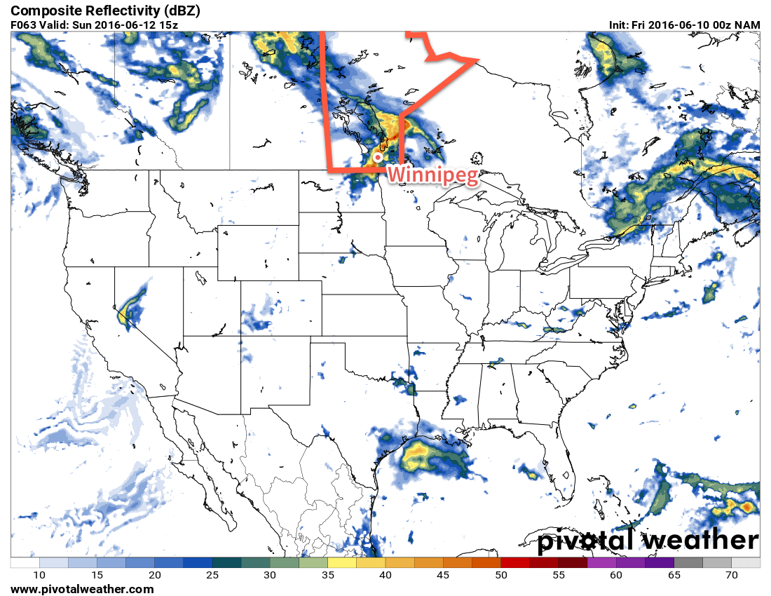
The NAM shows an area of rain tracking across the Red River Valley on Sunday morning.
Sunday will likely bring another bought of convective rainfall to the region. A shortwave riding over the Northern Plains will lift northeastwards into southern Manitoba on Sunday, spreading an area of rain ahead of it. There will be a risk of a thunderstorm associated with it, but at that point the risk looks small. Current indications are that the rain will start in the morning, be fairly intense, and end by midday with a widespread 10-15mm, however speed and timing may change between now and then. Temperatures will be cool with a high in the mid-teens and a low near 10°C. Winds will be moderate out of the southeast at 30-40km/h.
Heading into next week, it looks like things will finally settle a bit and we may get a stretch of warm, dry weather with daytime highs in the upper 20’s, overnight lows in the mid-teens or warmer, and little expected by way of widespread precipitation or significant storm threats.
Winnipeg’s seasonal daytime high is currently 23°C while the seasonal overnight low is 10°C.