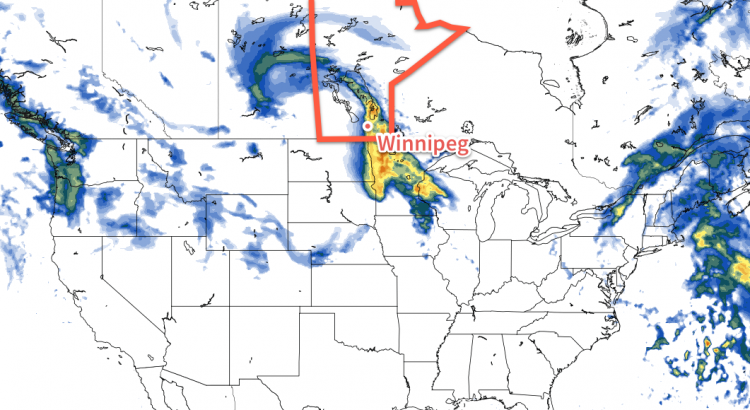
We’ll see one more nice day today before a potentially significant weather system affects us on Tuesday and Wednesday. Rain and snow is expected in southern Manitoba with this system, but exact amounts remain unclear.
Today will be another very nice day. Temperatures will climb into the mid teens over much of southern Manitoba, allowing our snow melt to continue. Many rural parts of southern Manitoba are already snow-free, but there is still snow to melt in sheltered areas. Skies will be mainly sunny, with breezy south-east winds.
A major low pressure system will affect southern Manitoba this week
A major low pressure system is expected to affect southern Manitoba on Tuesday and Wednesday. This system will bring a combination of rain and snow, which makes it difficult to forecast. At this time it appears that rain will be the main mode of precipitation over the Red River Valley. Models disagree widely on potential accumulation, so it is difficult to say exactly how much rain will fall. A “best guess” is that Winnipeg will see about 5-15 mm of rain. More or less rain could fall depending on how the system evolves.
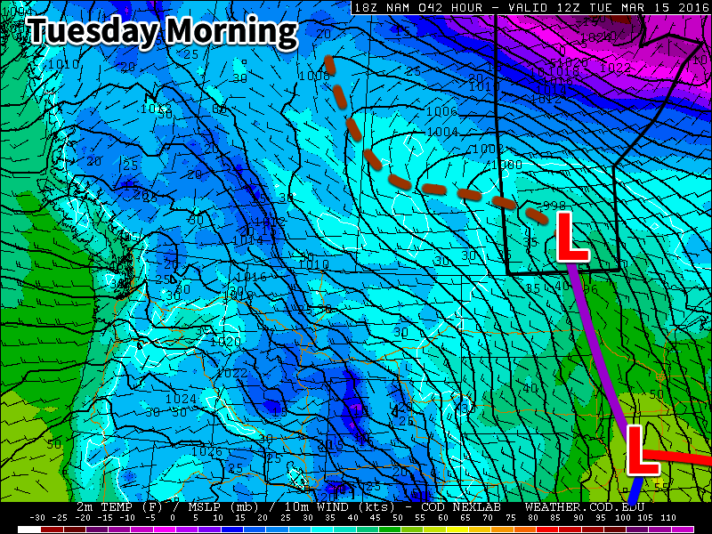
We will continue to be under the influence of this system on Wednesday, but temperatures will fall as we experience a stiff north-westerly flow. As a result of this cold air surging in from the north, rain is expected to change over to snow, with a couple centimetres of accumulation being possible. The exact amount of snow will depend on how much the system stalls over our area and how much cold air manages to infiltrate southern Manitoba. High temperatures on Wednesday are currently expected to be near 2C, which would not favour large accumulations.
Long Range
The end of the week is expected to be colder as the system from earlier in the week pulls down colder air from the north. Longer range models suggest that the second half of March will see a cooler pattern with outbreaks of colder arctic air. However, if we remain mainly snow-free following this week’s system, it will be difficult for very cold conditions to last long as the darker soil will be able to absorb much more sunlight than snow would.
The mild weather will continue today with daytime highs of +1 or +2°C today as yet more warm air washes over Southern Manitoba. The system responsible for this mild spell will be making its way across the region today and after it brings some mixed precipitation, it will push eastwards into Ontario, taking the warmth with it. Northerly winds will develop tonight and begin to usher in cooler, more seasonal temperatures.
Today will bring some more organized precipitation across the Red River Valley as the main disturbance that’s been responsible for the warmth this week moves across the region. With temperatures so close to the freezing mark, what type of precipitation will be falling is a bit of a difficult question to answer. Looking at the Red River Valley as a whole, we can say that there will be mixed precipitation, however for any one location may see just rain, just snow, or both. Even if snow falls, with the above-0°C temperatures, it won’t be able to accumulate much. By the time the precipitation tapers off, just 1-2 mm of rain or cm of snow will have fallen.
With light winds and above-zero temperatures, it also is possible that drizzle or fog patches are an issue throughout much of the day.
As the system moves into Ontario later today, northerly winds will begin developing over Southern Manitoba and draw in cooler air from the north. Drizzle or freezing drizzle will be possible through the early evening hours, but that risk should dissipate heading into the overnight period. Temperatures will dip to about -6°C with gusty northerly winds up to 30 km/h.
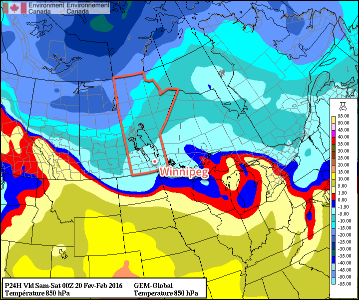
The GDPS shows the gradual return of colder air via 850mb temperatures.
Saturday will bring mixed skies and diminishing winds as the Red River Valley sees a weak ridge of high pressure begin to build in. There’s a bit of uncertainty to exactly how much cloud will clear out of the region; it will likely trend towards cloudier, but we should see a few sunny breaks through the day. Temperatures will recover just slightly from the overnight low to a high of -5°C. The colder weather will continue pushing southwards with gradual clearing through the evening & overnight that will allow temperatures to dip to an overnight low near -17°C.
Sunday will bring partly cloudy skies to Winnipeg, but the southern Red River Valley will likely see cloudier skies as a weak low pressure moves through North Dakota. This system will produce some light snow for areas further south, but in Winnipeg there will just be a chance of flurries. Temperatures will be slightly cooler than seasonal with a high of -12°C. Skies should clear on Sunday night as temperatures head to a low near -16°C.
Long Range: Not Cold For Long
This cool-down will be brief; by Monday daytime high temperatures approaching the freezing mark will return to the Red River Valley.
Temperatures will be variable next week with warm days giving way to 1-2 days of seasonal temperatures before warmer weather returns again. No significant precipitation events are expected through next week.
Winnipeg’s seasonal daytime high is currently -7°C while the seasonal overnight low is -18°C.
A low pressure system crossing the Prairies will bring another wave of unseasonably mild air into Southern Manitoba and help temperatures climb above 0°C for the second time this week. Heading into the latter half of the weekend, unsettled weather will develop over Southern Manitoba bringing flurries as cooler air begins gradually slumping southwards out of the Arctic and across the Prairies.
Today will be a much nicer day for Winnipeg than it appeared like it would be earlier this week, all thanks to a more northern track for today’s low pressure system crossing the province. As a result of this trajectory, Winnipeg will still see the warmth we expected before, but much less of the precipitation, which will now mainly fall through Central Manitoba and the Interlake before heading off into Ontario.
For the city, today will start off with a chance of…well, just about anything—snow, freezing rain, or showers—as a warm front pushes through and brings our temperatures above zero. As the warm front pushes off to the east relatively early in the day, we’ll be left with skies on the cloudier side and temperatures in the +1-2°C range. Windswe will start out of the south at around 30-40km/h before shifting to westerly behind the warm front at similar speeds. The chance for showers will redevelop mid-day and through the afternoon as a little bit of cooling aloft moves across the region. Expect temperatures to drop to around -2°C tonight with a few clear breaks developing.
This RDPS forecast showing accumulated precipitation through Friday shows how most of the precipitation is expected to our north and east
Saturday will bring more warm weather cloudier skies once again, although a few sunny breaks are certainly possible and the southwestern Red River Valley may actually end up seeing a fair amount of sunshine. Temperatures will climb to around +1°C with lighter winds than Friday.
A cold front will begin slumping southwards through the region on Saturday night. This will bring cooler temperatures and send our overnight low down to around -11 or -12°C under cloudy skies. Alongside the cooling will be a chance of some light flurry activity.
Sunday will be a cooler day with a high in the near -6°C or so. Under mainly cloudy skies, Winnipeg will see a slight chance for flurries throughout the day thanks to favourable temperatures throughout the lower atmosphere. This cooler weather will mark the leading edge of a return to seasonal and below-seasonal temperatures for a short while.
Long Range: Colder, But For How Long?
Looking forward into next week, it looks like cooler weather will return to the Prairies as the conditions that have supplied the warmer weather to the region over the past week collapse southwards and allow cooler Arctic air to slump southwards.
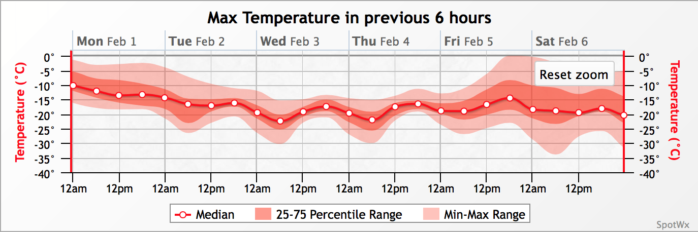
GEPS maximum temperature forecasts valid for the February 1-6, 2016 time period
The GEPS[1] is showing a transition into slightly below normal conditions next week. This image shows the maximum temperature expected in each 6-hour time period from Monday through Saturday. Ensemble forecast systems produce numerous forecasts, and then statistical analysis can be done on the output to (in theory) produce more accurate forecasts, especially in the long range. In the image above, the easiest way to understand it is that the value along the line is a fairly reasonable "most likely" temperature, while the red shading on either line represents the certainty; if there’s little shading extending from the line that means there is high confidence in the values; if there’s a lot of shading extending above and below the line, it means that there’s more uncertainty associated with the forecast at that time.
The GEPS shows fairly reasonable confidence that daytime highs will be dropping into the -15 to -20°C range early next week, a fair amount below the seasonal highs of -11°C for this time of year. With daytime highs in that range, it’s likely overnight lows will dip into the mid-minus 20’s. Heading toward the end of the week, though, there begins to be a lot more uncertainty on the weather pattern, so we’ll just have to wait and see for when the warm-up returns!
Environment Canada made headlines with the special weather statement for Winnipeg issued Monday with a referential start: winter is coming. And how.
Today will mark the beginning of a harsh slide into winter after a essentially a month of temperatures well above seasonal for this time of year. The change in the pattern will be brought courtesy a rather peculiar weather setup that will see a relatively weak Colorado Low moving north through Minnesota into Northwestern Ontario merge together with an Alberta Clipper quickly moving eastwards across the Prairies. Each system is moderately potent in their own right, but when combined, they will form a new storm system that will rapidly intensify, driving strong northwesterly winds through the province alongside the first significant snowfall for many regions of Southern Manitoba.
Today will start deceptively. Relatively light winds and temperatures climbing towards 5 or 6°C will give a false sense of security betrayed only by the increasing cloud cover that will build in through mid-day into the afternoon. Some light rain will develop over the Red River Valley this afternoon, which will mark the end of our above-seasonal temperature streak and usher in winter. As the rain moves into the region, winds will pick up out of the northwest to around 50km/h sustained with gusts as high as 70–80km/h. The rain will switch over to snow sometime in the evening and likely begin piling up fairly quickly as the strong winds rapidly cool the ground and other surfaces.
The strong winds and snow will persist through tonight as temperatures dip down towards –3°C or so as colder air begins filtering into the region. With snow piling up and such strong winds in place over the Red River Valley, it’s quite likely that driving conditions become quite poor as roads freeze, become ice covered, and see reduced visibility in blowing snow.
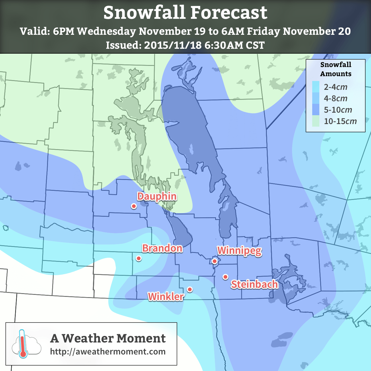
AWM Snowfall Outlook issued November 18, 2015
Thursday will continue to bring light snow and strong winds to the region as temperatures remain around –4°C or so. The winds will be a bit lighter than at their peak, but will likely remain near the 40 gusting 60km/h mark through much of the day before beginning to taper off in the evening. Overnight, other than some lake-effect snow streaming southeastwards off of Lake Winnipeg, there’s likely to be just a few flurries lingering in the region. Temperatures will dip down to –6°C for the overnight low.
In general, around 5–10cm of snow is likely to fall with this system through southeastern Manitoba, the Red River Valley and northwestwards into Parkland Manitoba. Exact amounts will depend on the timing of the change-over from rain to snow and how quickly the snow begins accumulating instead of melting on the ground.
Friday will be a mainly cloudy day with just a very slight chance of light, scattered flurries. Temperatures will recover only a degree or two from the overnight low with highs around –4°C. There may be a few clear breaks through the Red River Valley on Friday night, but overall there will still be a fair amount of cloud as temperatures head towards an overnight low near –10 or –11°C.
Colder Weather Continues Through The Weekend
The cooler weather, which while a significant drop from what we’ve been experiencing is, in actuality, just a couple degrees below seasonal values for this time of year, will persist through the weekend.
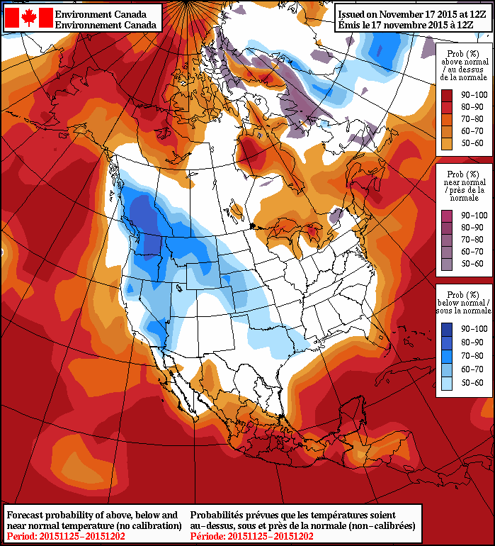
The NAEFS is showing a trend towards seasonal temperatures for the remainder of November.
Daytime highs around –5 or –6°C will be in place over Winnipeg & the Red River Valley this weekend, with a chance of some more flurries on Saturday improving to sunnier fare on Sunday. Overnight lows will be in the low minus single digits. So, while it may be a huge change from the weather we’ve been having, we’ll be shifting to more seasonal weather for the end of November.