Extratropical Storm Ita Brings Soaking Rains to New Zealand
The same cyclone as discussed in last week’s Elsewhere in Weather News article has continued its trek southeast and has brought torrential rains as well as strong winds to New Zealand. After making landfall on Australia’s northeast coast, Ita curved back out to sea while transitioning to an extratropical storm. Extratropical storms are characterized by well-defined frontal features as well as cold core as opposed to cyclones which are tropical in nature and have warm cores.
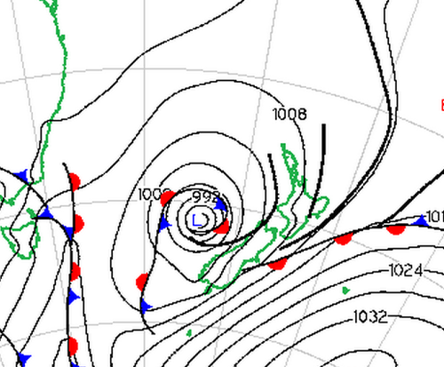
Surface map analysis on Friday evening (local time) of extratropical cyclone Ita just offshore of New Zealand. (Source: Met Service NZ)
The remnants of Ita brought torrential rains and fairly strong winds to New Zealand’s islands. These adverse conditions knocked out power to around 22,000 people in addition to washing away roads, wreaking havoc on Easter weekend travelers. Some water rescues also had to be executed due to people being trapped in their cars. It appears as though a general 100mm fell across the northern part of the island. Locally higher amounts (200mm+) were possible as upslope winds contributed to higher amounts where higher topography was present. The highest wind gusts also affected the northern and western side of the country, where winds coming straight off the ocean produced gusts as high as 115km/h in Westport.
Thankfully the extratropical cyclone is expected to exit the region and continue its track south, bringing more pleasant conditions to New Zealand for Sunday and Easter Monday. Another significant cyclone is churning this weekend, but thankfully in the open waters of the Indian Ocean. Although it is expected to reach category one, it will remain over open waters and is not expected to make landfall.
A storm system pushing through Southern Manitoba tonight will bring snow, rain and everything in between to Southern Manitoba tonight, marking a significant shift in the upper-level flow that will bring seasonal to above seasonal temperatures through the weekend and into next week.
Friday
7°C / +2°C
Increasing cloud. Rain beginning this evening. 10-15mm.
Saturday
10°C / 0°C
Clearing in the afternoon; chance of showers.
Sunday
11°C / 0°C
Mainly sunny. Chance of showers overnight.
First Significant Rain of the Year
Today will be a pleasant day; high temperatures will sit around 6 or 7°C this afternoon with mainly sunny skies giving way to increasing cloudiness this evening. Winds will begin to pick up this afternoon to around 30km/h. The big story, though, is the low pressure system that will track through tonight.
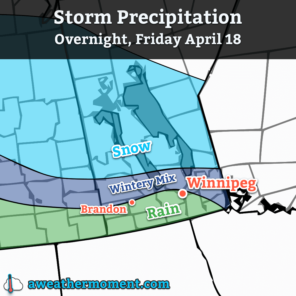
A major low pressure system will begin pushing into Southern Manitoba tonight. This system, marking the transition into a warmer weather pattern, will spread significant rain and snow through the province during the overnight hours. Things will start off in the afternoon through the Parkland region with snow spreading eastwards from Saskatchewan. As the system pushes towards the Interlake and Red River Valley, precipitation will extend southwards, primarily as rain and then push eastwards through the remainder of the night. Winds will also be fairly strong, with sustained winds around 30-40km/h and gusts up to 60km/h.
Multiple precipitation types will be coming into play again with this system. The primary rain-snow line, at this point, looks like it will sit 50-100km north of the Trans-Canada highway. This line is not set in stone, however, and will likely meander north and south as temperature profiles change and precipitation intensifies and subsides. Areas near the rain-snow line may see precipitation flip from one to the other multiple times. With this low pressure system freezing rain is not expected, but ice pellets or a rain/snow mix are entirely possible.
Expected precipitation types for tonight’s storm system.
Precipitation, while relatively short-lived, will be fairly intense with this system. The heaviest axis of precipitation looks to extend from Parkland Manitoba, through the southern Interlake and northern Red River Valley and then through SE Manitoba into NW Ontario. For those on the snow side of the rain/snow line in Parkland Manitoba (including Dauphin), snowfall amounts will peak at around 10-20cm with amounts tapering off towards the northern Interlake and the rain/snow line. For the areas that will see rain, amounts will be split into three main groups:
Location
Rainfall Amount
Extreme SW Manitoba (Melita)
<= 5mm
SW Manitoba & Southern RRV
5-10mm
Winnipeg/Northern RRV & SE Manitoba
10-15mm
Saturday will start off mainly cloudy with mist and fog scattered through the Red River Valley. There will be a slight chance of showers, particularly through the northern half of the valley through Winnipeg and into the Southern Interlake. For any activity that does occur, however, amounts will be fairly minimal. Winds will be relatively light and skies will begin to clear for a sunnier afternoon. The temperature will top out around 10°C.
Saturday night will see temperatures dip to around 0°C with light winds. It’s likely that the substantial precipitation coupled with rapid snow melt and calm winds will produce fairly extensive fog through the Red River Valley. Fog is notoriously difficult to predict, so we’ll keep tabs on things into the evening hours and try to give as much heads up one way or another as to what to expect. Just be aware that for travel overnight Saturday into Sunday, fog may play into the picture.
Warmer Weather Arrives
We’ll start pushing into the significantly warmer weather on Sunday as another low pressure system approaches, bringing with it another pulse of warm air. Temperatures in Winnipeg will climb to around 11°C on Sunday with light winds under mainly sunny skies[1]. Temperatures on Sunday night will drop to around 0°C once again, but we do have an ever so slight chance of seeing some showers overnight as a disturbance tracks along the U.S. border.
Daytime highs should sit near to just above normal through much of next week, generally in the 10-15°C range. No threats for precipitation are expected until the second half of the week.
If we end up with fog on Saturday night, we’ll see a cloudier Sunday morning, however skies should clear by late morning for a sunny afternoon. ↩
The GFS depicts an upper-level ridge building into our region early next week.
Winter-weary Winnipeggers can take solace in the fact that an end to the never-ending winter is in sight. There is increasing confidence that a large upper-level ridge will build into the Central U.S. and Southern Prairies early next week and finally bring some seasonal to slightly above seasonal temperatures to the region. First, though, we’ll have to make it through the rest of the week.
A Cold End to the Week
Cold temperatures will continue to persist through the remainder of the week with well below seasonal highs and lows expected. These cold temperatures are being caused by a large stationary trough of cold air over Hudson Bay that has locked the eastern Prairies into a northwesterly flow that has allowed cold Arctic air to spill southwards, dashing the warm-weather hopes of battered and beleaguered Manitobans.
Wednesday
-2°C / -17°C
A few clouds.
Thursday
0°C / -10°C
Partly cloudy. Slight chance of flurries.
Friday
5°C / 1°C
Late day cloudiness; warming up.
Tonight will be the coldest night for the remainder of the week in the Red River Valley thanks to another push of cold air on the back side of a low pressure system passing to our south. There will be a strong chance of another swath of record low temperatures broken – similar to Monday night – as overnight lows dip some 15-20°C below normal.
Thursday brings a similar high to today, around -2°C, however temperatures just off the ground will be a little bit cooler. This combination will result in stronger low-level instability and we could potentially see a few light flurries develop through the Red River Vally similar to what was seen on Monday afternoon. Overall the risk is very slight, though. Temperatures will drop to a more mild -10°C Thursday night as warmer air begins pushing eastwards.
Friday will be the warmest day so far this week. Temperatures look to climb above the freezing mark towards +4 or +5°C with only a bit of cloudiness to contend with. Winds will be a little breezy out of the southeast to around 20-30km/h, but overall it will be quite a pleasant day with plenty of sunshine. Some cloud will begin streaming in late in the day ahead of the next system pushing towards the region. The cloudier skies will help keep our overnight low fairly warm, with a chance we won’t even drop below 0°C. We may have to contend with some unpleasant weather through the overnight hours, though…
Big Shift on the Weekend
Precipitation amounts forecast on Friday night by the GDPS.
Models are all hinting towards some precipitation on Friday night into Saturday morning as a low pressure system lifts northeastwards through the Prairies. It’s still far too early to speak towards the system in much detail at all, other than saying the bulk of it looks to happen during the overnight period. Some models, such as the pictured output from the GDPS[1] really wind the system up and produce significant quantities of rain or snow while others lift the system much further north with little precipitation development. We’ll have more details on precipitation type and how much of what to expect later on in the week.
The bigger news is that this system marks a significant pattern shift as the upper level ridge we mentioned at the beginning of the article begins developing and pushing eastwards. As it does so, warmer air looks set to flood the Prairies, quickly launching our temperatures back towards seasonal to above-seasonal. Sunday will have temperatures close to normal[2] and we might see it get as warm as the low-to-mid teens on Monday, if we can manage to work past our snow cover.
Multiple days of near-to-just-above freezing temperatures coupled with the strong April sun should do quick work to melt the remaining snowpack across much of the Red River Valley. Melt will be minimal until the weekend, but even one or two days with temperatures in the 5-10°C range will do quick work with much of the remaining snow. Once we can eliminate the snow pack, extremely abnormal cold will be much harder to come by and it will be much easier to see seasonal temperatures.
Global Deterministic Prediction System – Canada’s long-term forecast model. ↩
Seasonal temperatures for Winnipeg currently are around 11°C for a daytime high and 0°C for an overnight low. ↩
A low pressure system pushing eastwards across the Southern Prairies and the Northern Plains will spread snow and rain into Southern Manitoba today. Amounts are not expected to be significant in the Red River Valley – especially in areas near the international border – but it will be one of the first “snowy” days of the year.
Total forecast precipitation (liquid-eqivalent) from Friday morning to Saturday morning.
Today
Friday 2°C / -2°C Cloudy with light snow beginning this afternoon.
Precipitation will begin pushing into the southern Red River Valley later this morning and into the northern half of the valley, including Winnipeg, this afternoon as the low pressure system begins working it’s way into the region. Precipitation will fall mainly as snow through the northern half of the Red River Valley while in the southern half of the valley some light rain will be more likely. Naturally there will be a transition zone somewhere in the central RRV where amounts will not be too significant with only a cm or two falling here in Winnipeg at most. Further south, up to a 3–4mm of rain could fall. Light snow will taper off in the evening leaving behind a chance of some flurry activity through the overnight hours. We’ll see a low dipping just below 0°C.
The Weekend
Saturday 2°C / -6°C Mainly cloudy; chance of flurries.
Saturday will be a mainly cloudy day with a slight chance of flurries throughout as cool, somewhat unstable air continues to push south behind the low. No significant accumulations are expected and we’ll climb to a high of around 2°C. The winds will be a somewhat gusty 30km/h out of the northwest through the day. Through the overnight things will be mainly cloudy, although a few breaks in the cloud are expected, as we dip to a low of about –6°C.
On Sunday skies will improve while temperatures do not. We’ll see a mixed sky with a high of only –1 or –2°C. A few light flurries may be possible in Winnipeg in the morning as we may be just grazed by a weak system passing through the Interlake. Cooler air will continue to filter southwards through the day and drop us to a very chilly –12 or –13°C on Sunday night under mainly clear skies.
After that, a fairly sunny, cool and quiet week is ahead next week as a large arctic ridge dominates the weather over the Eastern Prairies.