Elsewhere in Weather News: December 15th, 2012

Tropical cyclone Evan struck the Samoan Islands on December 13, bringing strong winds and heavy rain to the area.

NASA's Aqua satellite captured this image of Evan as it struck Samoa

NASA’s Aqua satellite captured this image of Evan as it struck Samoa (Source: http://earthobservatory.nasa.gov/NaturalHazards/view.php?id=79989&src=nha)

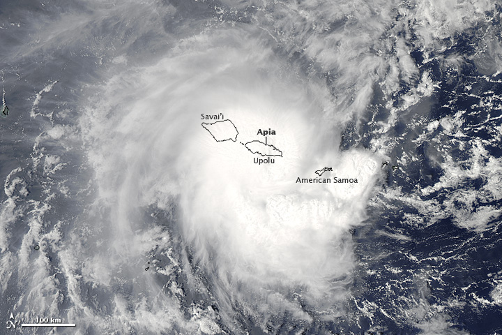
Evan was a category 1 cyclone when it struck the Samoan Islands region on Thursday, with maximum sustained winds of 144km/h. The storm came onshore near Apia, the capital of Samoa, and the country’s largest city (population 37,708). The cyclone destroyed buildings, ripped up trees, and took down phone, internet, and electricity services across Samoa. In addition, the heavy rain generated by Evan caused widespread flooding. The death toll from Evan is at least 2, with the cyclone being called the worst in many years by local residents.

People walk over a destroyed bridge in Samoa's capital Apia, Friday, Dec. 14, 2012

People walk over a destroyed bridge in Samoa’s capital Apia, Friday, Dec. 14, 2012 (Source: http://www.wunderground.com/blog/JeffMasters/article.html?entrynum=2311)

Evan has taken an unusual track so far, first moving eastward toward Samoa, then making a 180 degree turn over the islands, with its track now taking it westward toward Figi. Evan is currently intensifying, with maximum sustained winds presently at 185km/h. That is high enough to make it a category 3 cyclone on the Saffir-Simpson scale. Current forecasts suggest that the cyclone could approach category 5 status (winds >252km/h) this weekend, before hopefully weakening somewhat prior to affecting Figi. Despite its expected weakening trend ahead of hitting Figi, Evan could become a major disaster for the country, with the country’s leader Commodore Frank Bainimarama’s quoted as saying the following “Fellow Fijians I cannot stress how serious this is, every Fijian will be affected”. Figi is a small country consisting of 332 islands with a population of approximately 850,000.

Weather Roller Coaster

This week will be a bit of a meteorological roller coaster as our temperatures climb up, then fall rapidly back down again.

GEM-Regional predicted rainfall total for Monday

GEM-Regional predicted rainfall total for Monday

Monday looks to be the warmest day of the week with above freezing temperature of 1 or 2C expected in Southern Manitoba. Some light rainfall is expected in south-eastern parts of the province out ahead of a cold front. This may lead to icy conditions on Monday night as temperatures drop below zero behind the front. Winnipeg will be right on the edge of this area of rain, so the city isn’t expected to see more than a millimetre or two of rain at most. In fact most models take the area of rain just south-east of Winnipeg, so the northern part of the Red River Valley may end up with no precipitation at all. Temperatures will plummet on Monday night in the wake of the cold front with values dipping down into the minus double digits by Tuesday morning.

High temperatures will remain down in the minus teens in Southern Manitoba on Wednesday, with most areas in the -11 to -14C range. A weather system emerging from the mountains in Alberta will develop a southerly flow over Manitoba on Tuesday night. As a result, Tuesday night will be characterized by increasing warm air advection, allowing for warmer air to filter into Southern Manitoba during the overnight period. We will continue to experience warming on Wednesday as a stiff south wind continues to bring in warmer air. Unfortunately, the wind will be very strong, making conditions much less comfortable than the temperature alone would indicate. Highs on Wednesday will be in the low to mid minus single digits in Southern Manitoba, but wind chills values will be in the -10 to -15 range due to the strong south wind.

Another cold front will move through on Wednesday night or Thursday, setting up a chilly end to the week. No significant precipitation is currently in the forecast for Southern Manitoba this week as the main storm track remains to our north and west.

Winter Looms

The weather for most of this week will be fairly calm and uneventful, but current forecasts show the potential for a major winter storm next weekend.

The ECMWF model is predicting that a major winter storm will impact Southern Manitoba next weekend

The ECMWF model is predicting that a major winter storm will impact Southern Manitoba next weekend

Monday’s weather will be fairly seasonal, with high temperatures just above zero. There may be some light rain during the afternoon and evening hours as a trough of low pressure swings through, though nothing particularly significant. Tuesday will see little change from Monday, with temperatures once again in the low single digits. Perhaps the biggest difference between these two days will be the wind direction, with the wind being north-westerly on Tuesday, as opposed to southerly on Monday. Wednesday will once again be a seasonal day, with temperatures around or slightly above zero.

The main attention this week will be focused on the potential for a major weather system next weekend. Weather models are currently showing a significant Colorado Low system impacting Southern Manitoba next weekend, with the potential for heavy snow and strong winds. At this point it is impossible to predict exactly how this system will affect us, other than to say it could cause significant disruptions. Just as it is impossible to know the exact impacts of this storm this far in the future, it is also not possible to know for sure if this storm will hit us at all. Based on the latest guidance, there does appear to be a reasonable chance of it impacting Southern Manitoba in some way, but we won’t be sure for a few more days. In the meantime, we’ve got some interesting weather to talk about!

More Active Weather

More active weather is in store for this week with multiple chances for precipitation. The question is whether that precipitation will be solid or liquid.

Low pressure system passing to the south-east on Thursday

A low pressure system is currently expected to pass to our south-east on Thursday, generating minimal impacts in Manitoba

The weather to start the week will be fine, with temperatures generally in the high single digits on Monday and perhaps a few double-digit readings here and there. There will be increasing cloudiness during the day as a weather system approaches. This system will begin to spread rain over Southern Manitoba on Monday night with precipitation persisting into the day on Tuesday. Highs on Tuesday will remain very similar to Monday, but the rain will make it a considerably more miserable day. Total accumulations from this system will generally range from 5 to 15mm. As Tuesday’s system departs our region on Wednesday, cooler air will sweep in from the west making for a chilly and windy middle of the week. Temperatures on Wednesday will be in the mid single digits with a gusty west wind.

There has been much talk about the weather for later this week. Some models have been showing a significant Colorado Low system hitting portions of Manitoba on Thursday and Friday. However, other models show little or no precipitation for us later this week. At this point the consensus seems to be that it is unlikely Southern Manitoba will be getting a major blizzard later this week. Most models depict a moderate strength low system sliding past us through Minnesota and up into North-Western Ontario, perhaps bringing a few flurries or rain showers to Southern Manitoba, but not a major winter storm. Some models still show a fairly deep low pressure system to our east over Northern Minnesota and North-Western Ontario later this week, but it looks like it will be sufficiently far away to prevent us from seeing its main impacts. So at this point it appears unlikely that we’ll be seeing any significant amount of the white stuff later this week. However, expecting the unexpected as always a good saying to live by in the weather business.