Thunderstorm Threat Ramps Up Over Southern Manitoba

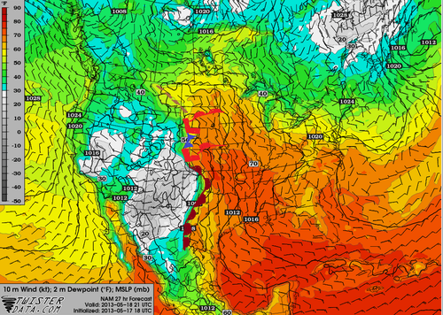
A broad shift in the jet stream is set to bring an influx of moisture from the Gulf of Mexico northwards into Southern Manitoba while a southwesterly flow aloft sets up bringing multiple upper-level disturbances & instability over the region. The increased moisture, combined with the relatively unchanging southwesterly flow will set us up for multiple days with a significant thunderstorm risk over the southern portion of the province.

Wednesday

Wednesday

26°C / 15°C
Afternoon clouds; chance of showers/thunderstorms.

Today’s weather will be dominated by an approaching warm front from Saskatchewan. We’ll might see few showers exiting the Red River Valley this morning – left over from some weak nocturnal convection – with plenty of sun through the morning. The sun will heat things up fairly quickly and there’s a chance we’ll see some showers or thunderstorms develop early-to-mid afternoon as we warm up. Any storms that develop today will not likely become severe; a majority of the shear will be isolated in the upper levels and the complete lack of low-level shear may even be substantial enough to inhibit storm development. We’ll drop to an overnight low of around 15°C as we head into a busy end of the week.

Thursday

Thursday

25°C / 16°C
More cloud than sun; getting humid. Showers or thunderstorms likely.

Thursday presents Southern Manitoba with plenty of heat and rising humidity as the day progresses. We’ll see a high of nearly 26°C while the dew point climbs into the high teens through much of the Red River Valley by the end of the afternoon. Whether or not that humidity will make it up to Winnipeg will depend on how soon the winds turn from northeasterly to southeasterly; the sooner they do, the more humid we’ll get. The building heat and humidity will create a fairly potent setup for severe storms, however.

image-1

Severe thunderstorm outlook issued on Wednesday, June 19 @ 6:30AM CDT

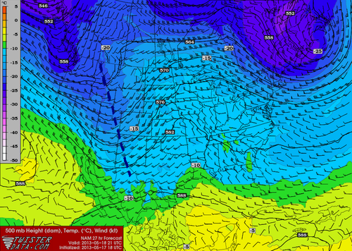
By late afternoon CAPE values are expected to climb to 2500–3000J/kg near the international border thanks – in no small part – to the climbing dew points. LI values are forecast to drop to the –8 to –10°C range, indicative of the steep lapse rates aloft and the potent storm potential. Good wind shear will be in place with southeasterly surface winds veering to a strong westerly wind at 500mb. In addition, a shortwave is forecast to eject into Central North Dakota by mid-afternoon and push northeastwards into the RRV by evening, bringing with it enhanced destabilization and lift. One big question mark remains, though. While we have plenty of moisture, instability, shear, and a trigger, the cap may be make or break storms for the day, or rather, the lack of a cap may.

Models are having a hard time determining just how warm it will be in the mid-levels of the atmosphere; some want to establish a cap that will inhibit convection until later in the day, but others keep the environment uncapped which will result in the maintenance of an MCS coming out of Saskatchewan on Thursday morning. In that case, we’d see showers and thunderstorms build into the Red River Valley in the morning and persisting through much of the day. Conditions still look somewhat favourable for the development of isolated strong to severe storms in this scenario, despite the ongoing showers and thunderstorms. If the cap does develop though, the MCS will likely die out to our west and a significant threat for severe thunderstorms would mount in the Southern Red River Valley.

It’s still too early to be too certain on the threat for Thursday as models are still working to resolve the interaction with various shortwaves and the main upper low anchored over the American mountain northwest. For now I’ve extended a slight risk through Southern Manitoba along the International border.

Friday

Friday

26°C / 13°C
Mix of sun and cloud; humid.

Friday will end up a fairly hot day with temperatures climbing into the mid-to-upper 20’s with dew points rising to nearly 20°C. The humidity will make it feel closer to the low-to-mid 30’s, so it definitely looks to be one of the first really hot days of the year. Conditions should hold out through most of the day before thunderstorms develop in North Dakota and begin pushing northwards. It’s still too early to tell their exact path which will be heavily dependant on where exactly upper-level features lie. They may end up moving into SW Manitoba, the RRV or the Whiteshell through Friday night.

We’ll have a busy few days ahead so expect plenty of updates in the comments below! Briefly looking ahead to the weekend, Saturday and Sunday both look showery over much of Southern Manitoba with a risk of thundershowers. There will be some breaks here and there, but we’ll take a closer look at that on Friday.

Beautiful Days Ahead

Beautiful weather will continue across southern Manitoba through the next few days as a ridge of high pressure works it’s way across the Province. Things will turn stormier heading into the weekend as a potent upper trough pushes inland from the Pacific.

Today & Tomorrow

Wednesday

25°C / 12°C
A few clouds in the afternoon.
Thursday

25°C / 12°C
Description

Over the next couple days mainly sunny skies will dominate as a surface ridge slowly works it’s way across the province. Unlike the past couple days where we’ve enjoyed sunny skies here in the Red River Valley while areas further north in the Interlake and Central Manitoba were stuck underneath extensive cloud cover & showers, pretty much the entirety of Manitoba will be seeing plenty of sun and temperatures in the mid–20’s. Today we’ll climb to around 24°C and probably climb a degree or two higher for Thursday. Overnight lows will be comfortably seasonal, dipping down to around 12°C.

Things will begin taking a turn on Friday, though, as a strong southerly flow develops which will begin to push heat and moisture northwards through the High Plains and into the Southern Prairies. While it looks like the end of the week will have quite a bit of thunderstorm activity in Saskatchewan, things aren’t quite as clear cut here. Let’s take a look at how things look to pan out for us right now.

Friday

Friday

23°C / 13°C
Increasing cloud with risk of a thunderstorm. Chance of thunderstorms overnight.

A strong southerly flow will develop on Friday as the upper trough begins it’s way inland. Winds will increase to around 40km/h up and begin to bring moisture northwards. This will feed into a broad area of low pressure working it’s way across the Prairies. With the strong feed of moisture streaming northwards, we’ll likely see increasing cloudiness fairly early in the day which will limit our daytime high to a few degrees cooler than today or tomorrow. At this point, no severe storms are expected in the Red River Valley although a few scattered thunderstorms may manage to pop up, especially over the western RRV; for severe storms conditions look to be far more favourable further west in Eastern Saskatchewan or extreme SW Manitoba where the apex of the 850mb warm nose will reside with it’s associated low-level jet. Conditions there look favourable for the potential development of severe storms, although it may get messy very quickly with linear upscale growth shortly after initiation. Since the conditions there don’t directly pertain to the Red River Valley, I’ll leave a discussion of the severe weather potential for that region in the comments below.

image-1

Rainfall forecast for Friday night (Sat 00Z – Sat 12Z) from the GDPS.

The storms that fire Friday evening will continue through the night at least as a band of rain but more likely as an organized area of nocturnal thunderstorms. The low looks to lift northwards through the night before continuing eastwards, and the storms are expected to follow suit, moving ENE after initiation. At this point, it looks quite likely that Friday night will be a stormy night in the Interlake, however in the Red River Valley things are more uncertain. With much of the forcing lifting northwards, storms may have a difficult time surviving further south where lift will not necessarily be lacking, but not nearly as focused. Wherever the storms do go, the threat for severe storms will likely continue into the night. A strong 40+kt 850mb low-level jet will provide ample lift and moisture for the system and help maintain 1000+J/kg MUCAPEs through the night. The main threat with these storms would be large hail and the potential for strong straight-line winds.

We’ll keep a close eye on this system and have a more comprehensive look at it on Friday morning’s post. Until then, get out there and enjoy the beautiful weather!

Elsewhere in Weather News: May 18th, 2013

Severe Weather Event South of the Border: Possible AWM Chase Sat/Sun

Trough

Negatively-tilted trough on Saturday late afternoon. (NAM) (Map source: Twisterdata)

The same system that will cause Southern Manitoba to have a rainy May long weekend is expected to produce a string of severe weather days across the Central US, starting today, continuing through at least Tuesday. A negatively-tilted longwave trough approaching from the west will help to provide the necessary wind shear, lift, and instability for severe storms to develop. A broad surface low with an extending cold front from Central South Dakota through Nebraska will be in place with a warm front slicing through north-east South Dakota. Another, stronger, low pressure center will be in place in Kansas with an extending dryline all the way down to Texas. These features will offer enough lift for severe storms on Saturday. This, combined with other severe weather ingredients such as a stiff low level jet (LLJ), high amounts of instability, deep low level moisture and low cloud bases is ideal for severe weather and tornadoes. The Storm Prediction Center has issued a Moderate Risk for Nebraska and Kansas with a Slight Risk extending up to North Dakota for their 2 Day Outlook as of Friday night.

Surface Analysis

Surface analysis of the Plains. (Map source: Twisterdata)

As of Friday evening these ingredients appeared to be maximized in the vicinity of north-western Kansas near the Nebraska border. Storms will not be confined to this area though, as strong to severe storms will still be possible into South Dakota and down into Oklahoma, but whether they will be tornadic or not is still to be seen.

The ingredients that will be in place tomorrow in South Dakota:

  • Instability: about 2000J/Kg of MLCAPE (mixed layer)
  • Surface dewpoint: 18°C
  • Shear: 40 knots (0-6km shear)
  • LLJ: 20 knots
  • Lifting condensation levels (cloud bases): around 750m

With the LLJ being only 20 knots, an AWM Chase is still up in the air. If models tend towards a stronger LLJ, the chase will likely be on with a target somewhere in Central South Dakota.

Sunday also offers a significant severe weather threat as the trough continues its trek towards the east. Severe weather risk would extend into Southern Minnesota all the way down to Oklahoma. There is still some uncertainty about Sunday but it does look like another significant severe weather outbreak day for the Plains and Upper Mississippi Valley. Stay tuned in the comments section as the event approaches, updates will be posted.

AWM Chase is On!

Two of the AWM team members will be out chasing this setup along with a student from the University of Manitoba. You can keep up with their chase right here:

new TWTR.Widget({
version: 2,
type: ‘list’,
rpp: 30,
interval: 30000,
title: ‘May 18, 2013’,
subject: ‘AWM North Daktoa Chase’,
width: ‘auto’,
height: 500,
theme: {
shell: {
background: ‘#3c3c3c’,
color: ‘#eeeeee’
},
tweets: {
background: ‘#eeeeee’,
color: ‘#2c2c2c’,
links: ‘#489ce1’
}
},
features: {
scrollbar: true,
loop: false,
live: true,
behavior: ‘all’
}
}).render().setList(‘WeatherInThePeg’, ‘awm-team’).start();

A Scorching Week to End With A Bang

Temperatures are set to soar for the remainder of this week as heat sourced from the Gulf of Mexico builds into Southern Manitoba. Residents across all of Southern Manitoba should begin to prepare for a potentially dangerous end-of-week though, as a powerful low pressure system will threaten the first significant severe weather outbreak of the season.

850mb Theta-E Chart for 06Z Thursday

850mb theta-e (a form of measuring temperature) chart valid for 06Z Thursday 07 May. The light-red arrows depict the advection of heat from the Gulf of Mexico through Southern Manitoba.

A southerly flow of air aloft, aided by a long-wave trough over the Rocky Mountains to our west and a blocking high to our east, will bring us our hottest days of the year through the rest of this week. Temperatures at 850mb are expected to rise to nearly 20°C today, which will result in daytime highs between 25-30°C through the second half of this week.

A weak low will move through Southern Manitoba on Thursaday night ahead of the main upper trough and while parameters don’t look too great for severe weather, a band of thunderstorms will likely develop in the late afternoon or early evening, intensify, and slowly move east-northeast. While tornadoes aren’t a likely threat with these storms on Thursday afternoon/night, CAPE values in the range of 1250-1750 J/kg combined with LIs near -5 and 20-30kt of bulk shear should provide enough for a threat of large hail. The slow-moving nature of the line of storms could potentially also produce a risk of locally heavy rainfall, with as much as 0.75-1.25” falling over a relatively short period of time. While showers will be commonplace over southwest Manitoba throughout the day on Thursday, the risk for showers does extend eastwards through the western and central Red River Valley in the afternoon. The bulk of precipitation will occur with the thunderstorms that develop in the evening, though.

This is still about 36 hours away, though, and things could change quite a bit between now and then. Models are having a hard time degrading the blocking pattern that’s in place right now, and some are much more progressive with features and some are much slower. If things end up more progressive than they look right now, there may be minimal storm threat for Thursday night.

Night 2 Thunderstorm Outlook

Thunderstorm Outlook for Night 2 (00Z to 18Z June 08).

Taking into account the various speeds, the current area that might see storms on Thursday afternoon/evening looks to be the area bounded from the US border north to Brandon, up towards Dauphin/Swan River, then eastwards across the Interlake and southwards down the eastern Red River Valley. Storms will exit through the Central/Northern Whiteshell. While the potential for heavy rainfall exists, I do not feel enough confidence in it to justify any slight risk categorization on the outlook. The storms will likely be marginally severe, though, so it’s important that they are not ignored with the prospect of even bigger storms on the weekend.

Friday looks to be another warm day; debris cloud left behind from Thursday night’s convection should clear bout by lunch time or early afternoon which will allow the sunshine to warm us up to the mid-to-high 20’s. Dewpoints will build through the afternoon pushing up to 18 or 19°C, making it feel quite humid. The main upper trough is set to move in on the weekend, though, and what a system it looks to be.

SPC Day 4-8 Outlook

SPC Day 4-8 Severe Thunderstorm Outlook

I’m not going to talk too much about Saturday’s setup yet, as it’s still a ways out and in this particular setup, the exact specifics are sure to change with every model run until it’s much closer. We’ll be under the influence of two strong shortwaves that will push copious amounts of instability over Southern Manitoba. CAPE values look to exceed 2500 J/kg and potentially be as high as 5000-5500 J/kg; this, combined with a weak cap north of the warm front and favorable shear profiles looks to point at a potent setup for severe thunderstorms with high probabilities of (extremely) large hail, strong winds, and elevated risks of tornadoes. The setup is similar to other tornado-producing setups of years past, including the Pipestone tornado of 2007.

We’ll have plenty of discussion about the upcoming storm threats in the comments, so be sure to check back often for the latest information about this weekend’s potentially dangerous storm outbreak.