Benign weather will continue over the Red River Valley for the next few days as a weak ridge of high pressure remains entrenched over the region until Friday. Heading into the weekend, however, it looks like rain may be possible as a low pressure system moves into the region through the day.
There isn’t a whole lot to say regarding the coming days, so I’ll keep this post fairly brief! The weather for today and tomorrow will be largely dictated by a weak ridge of high pressure over the region that’s more a result of larger low pressure systems to our west and east than being particularly potent in and of itself.
Today will see temperatures climb to around 23°C with breezy winds building out of the north to 30–40km/h thanks to a low pressure system passing to our east. The day will start overcast with some mid- to high-level cloud that will gradually clear out through the day. Winds will taper off this evening as low temperatures head to around 9°C.
Thursday will be mainly sunny day with light winds and a high near 25°C. Expect a low near 13°C on Thursday night.
The GDPS is showing a low pressure system moving through Southern Manitboa on Friday night capable of bringing some rain to the Red River Valley.
Friday will see increasing cloudiness, particularly in the afternoon as a low pressure system begins working into the region. Temperatures will climb to around 25°C. Friday night will likely bring some rain, although specifics are still quite fuzzy. Temperatures will dip back down to around 13°C again.
Mixed Weekend
This weekend looks mixed at this point, with slightly cooler, cloudier weather on Saturday with a chance of showers and sunnier conditions on Sunday. There’s quite a bit of uncertainty with Friday night/Saturday’s low pressure system, so it’s a bit early to make much in the way of concrete forecasts. High temperatures will likely be in the low 20’s with a chance of warmer weather returning for the beginning of next week.
The pleasant spell of cooler, drier weather is coming to an end today as a warm front pushing eastwards across the Prairies brings unsettled weather today and then a deeper southerly flow which will help the heat and humidity slowly build up through the region into the end of the week.
Wednesday
Today will be the first active day of the week as a warm front approaches from the west and pushes through the Red River Valley later this afternoon & into the evening hours. This system will spread showers and thunderstorms across southwestern Manitoba this morning and gradually push them towards the valley through the day. The rain will likely hold off until late in the afternoon or early this evening here in Winnipeg. Temperatures will climb into the low 20’s across the valley with winds picking up out of the south-southeast to 20–30km/h with some gustiness on top of that by mid-to-late afternoon.
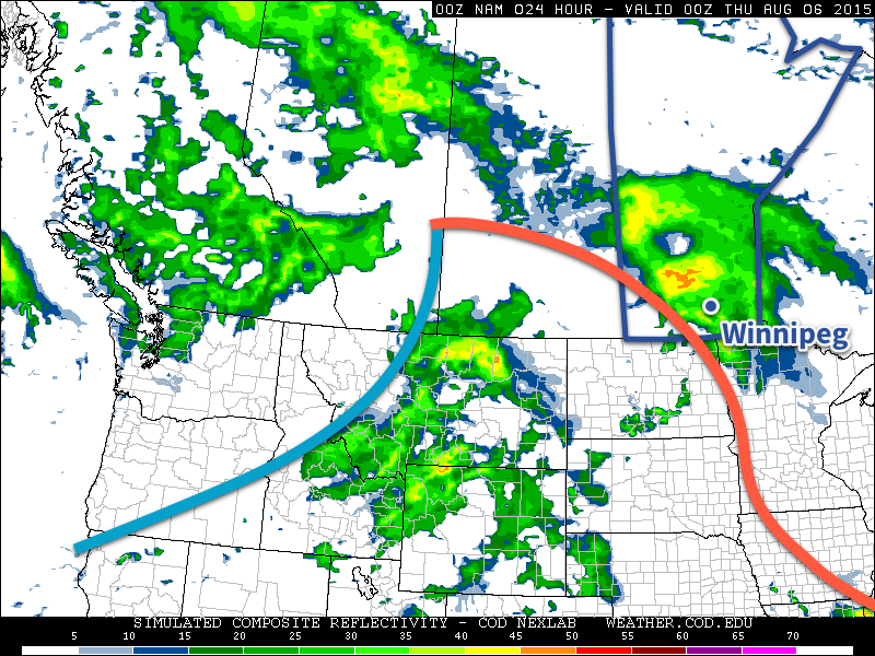
The NAM simulated RADAR refliectivities show a large swath of showers moving through Southern Manitoba this evening as a warm front pushes eastwards.
With the showers there will be a slight chance of an embedded thunderstorm…if we can manage some heating through the day with a bit of sunshine. If it ends up being overcast for a large area ahead of the front, the thunderstorm activity will likely be fairly mild with little-to-no chance of severe weather. On the other hand, if some sunshine manages to heat things up a bit, there will be a very borderline risk of some marginally severe wind or hail with some of the storms. That said, it doesn’t look particularly likely that we’ll see too much thunderstorm activity and, rather, we’ll see more moderate shower activity. The exception to this rule will be over southwestern Manitoba where there will be a slight risk of severe thunderstorms with main threats of large hail and damaging winds.
By the time things clear out late in the evening, most places will likely have seen around 5–10mm, but localized amounts of 10–20mm are possible. Temperatures will drop to lows in the mid-teens tonight.
Thursday
Thursday will be a muggier day with temperatures climbing into the mid–20’s. There will be some sunny breaks, but skies look to be trending towards the cloudier side of things. Another disturbance begins pushing into our region later in the day, which will bring another chance for showers or thunderstorms mid-afternoon into the evening hours. Temperatures will dip to the mid-teens again on Thursday night with a continued chance of shower activity.
Friday
Friday will see a more organized thunderstorm threat return to Winnipeg & the Red River Valley as the main upper-level disturbance swings through the province. Temperatures will climb to around 26°C or so with any leftover humidity getting flushed out by drier westerlies at around 30km/h. We may see some pop-up thunderstorms through the day, but at this point they don’t look like they’ll bring any severe weather. Friday night will see temperatures dip back to the mid-teens with a chance of some wrap-around shower activity pushing into the Red River Valley form the north on the back-side of the departing upper low.
Weekend Looks Pleasant
Looking ahead, the weekend looks great with high temperatures in the upper 20’s, relatively comfortable humidity, and little in the way of precipitation expected thanks to a ridge of high pressure working its way across the Prairies. Finally, rainy weather during the work week turning beautiful for the weekend!
This week will start out on the cool side with high temperatures in the low twenties.
Monday
Today will be mainly sunny with temperatures in the low twenties. The average high temperature for early August is 26°C, so this will represent cooler than normal weather. The wind will be north-west at 30km/h.
Tuesday
Tuesday will see much the same weather as Monday, with temperatures in the low twenties. Skies should once again be mainly sunny and winds will be light.
Wednesday
Wednesday may feature showers in southern Manitoba as a low pressure system passes through the region. Accumulations look to be fairly small at this point, so it will not be a significant event. Besides the rain, temperatures will remain below seasonal with highs in the low twenties. Winds will be breezy from the south.
After a busy couple weeks across Southern Manitoba, a stretch of mild, fairly quiet weather is ahead thanks to weak upper-level ridging over the eastern Prairies.
Today and tomorrow will both be pleasant days with a few afternoon clouds and highs in 26 or 27°C range. Winds will be a bit breezy out of the west today, but much calmer conditions will be seen on Saturday over the Red River Valley. Expect an overnight low near 10°C tonight and in the mid-teens on Saturday night.
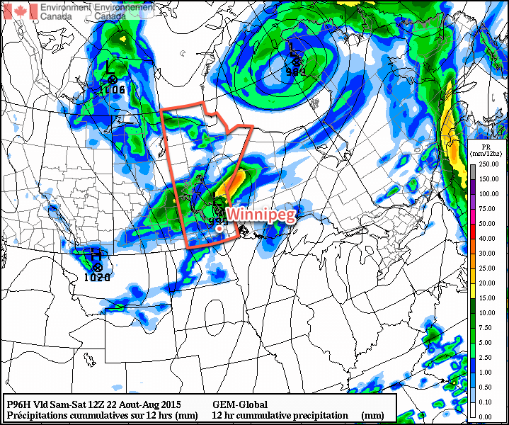
The only chance for precipitation will come late overnight Saturday or Sunday morning as a trough rotates through the Interlake into the Red River Valley. It doesn’t seem like the showers will be too intense or organized, so at this point it seems like there’s just a slight chance of them. Otherwise, Sunday will be a fairly pleasant day with a high in the mid-20’s and winds picking up out of the northwest through the day to around 30km/h.
The RDPS is forecasting temperatures in the mid-to-upper 20’s over Southern Manitoba for Saturday afternoon.
Early next week looks to start off a little bit cool with highs only in the low-to-mid 20’s. At this point, it looks like the next chance for any organized precipitation will hold off until the middle of next week!