Windy Wednesday Marks Return of Arctic Air

Moderate northwesterly winds will move through the region today, ushering significantly colder temperatures into southern Manitoba.

Hope you haven’t put the deep freeze gear away yet, Winnipeg, because another Arctic pipeline is about to set up and send substantially colder temperatures back into the Prairies. It all begins today as a cold front slumps southwards through the region behind yesterday’s potent low pressure system, ushering in northwesterly winds of 30 to 40 km/h. These gusty winds may produce some blowing snow through the Red River Valley, but visibility should remain better than it was yesterday at times. Skies will cloud over through the day as temperatures fall to around -19°C. Once the cloud moves in, there will be a chance of flurries but no accumulating snow is expected.

Temperatures will then drop to around -26°C tonight with fairly cloudy skies continuing.

Thursday will see the first of what may end up being many Arctic highs move through the region. Winds will remain light, but temperatures will reach a high of just -20°C under partly cloudy skies. Temperatures will dip to a low near -25°C on Thursday evening.

Skies will head back to being cloudy on Friday as a weak shortwave rolls across southern Manitoba, bringing with it the chance for some light snow. Temperatures will climb to a high near -17°C with light winds. Another Arctic high follows hot on the heels of this disturbance, though, and temperatures are expected to drop towards -30°C on Friday night as skies clear out.

Long Range Outlook

The long-range forecast looks cold, all thanks to the polar vortex.

The polar vortex is expected to be a prominent feature over the eastern Arctic for the next 14 days

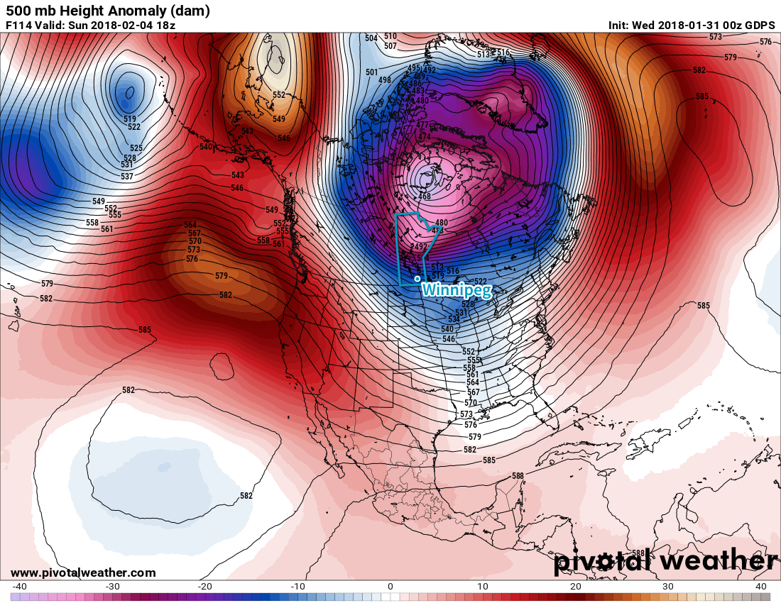
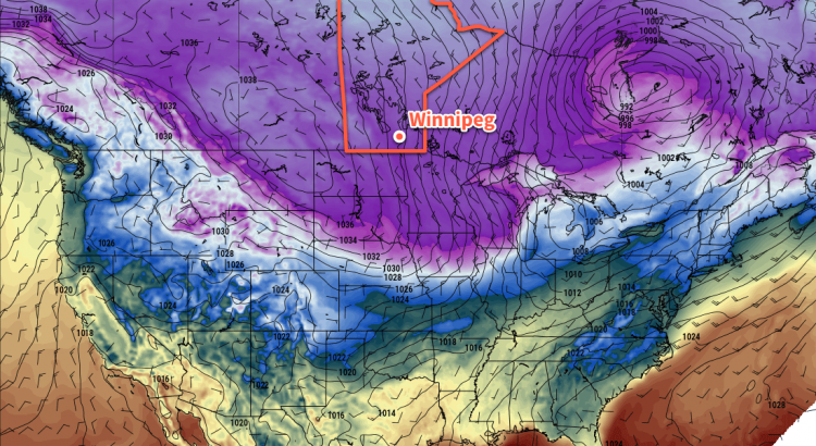
Currently relatively week, the polar vortex will intensify over the coming days, shifting southwards from its current location near the Melville Peninsula – north of Hudson Bay – towards Southampton Island and the Kivalliq coastline of Nunavut. As it intensifies and shifts, the overall pattern over the Prairies will shift from the west-east flow that has brought relatively mild temperatures recently to a north-northwest flow that will allow bitterly cold air to work southwards out of the Arctic.

Temperatures over the next two weeks won’t be cold all the time; the occasional system passing through will drag waves of more seasonal air across the Prairies, but the general pattern will support those weak systems quickly being followed by another shot of very cold air.

This pattern is expected to last for the next 7-14 days, and will end when the polar vortex begins losing some of its structure and retreats northwards.

Winnipeg’s seasonal daytime high is currently -11°C while the seasonal overnight low is -21°C.

Tuesday Storm Sends Winnipeg On A Temperature Roller Coaster

A potent low pressure system moving through Manitoba on Tuesday will send temperatures in Winnipeg soaring, only to crash back down just as quickly. Alongside the warmth, Winnipeg will see something that has been relatively elusive this winter: snow.

A ridge of high pressure over the region today will bring cold and calm conditions to Winnipeg. Under variable cloudiness, temperatures will climb to a well below seasonal high near -17°C. Winds will remain light.

Conditions will begin deteriorating tonight as a potent low pressure system begins pushing eastwards across the Prairies. Temperatures will dip a few degrees in the evening, then climb towards -15°C by Tuesday morning as skies cloud over and winds pick up out of the southeast to around 40 km/h.

Snow will move into Winnipeg early Tuesday morning ahead of an advancing warm front. The heaviest snow will likely fall during the morning rush hour, then gradually taper off into the afternoon. Winnipeg will likely see around 5 cm or so of snow during the day, with amounts increasing into the 15 to 25 cm range across central Manitoba.

Expected snowfall totals Tuesday morning through Wednesday morning

Update on Winds

Winds will be quite strong out of the southeast throughout much of the day, with winds of 40 gusting 60 km/h strengthening to 50 km/h with gusts of 70-80 km/h throughout the remainder of the day. These strong winds combined with falling snow will produce very poor visibilities in blowing snow with the potential for white-out conditions on area highways.


Temperatures will climb quite substantially on Tuesday as the warm front passes and temperatures reach the daytime high around -1 or 0°C. Winds will ease to around 20 km/h as the low passes through the Interlake, then strengthen to 30-40 km/h out of the west-northwest on Tuesday night as the low exits the region.

Skies will remain mostly cloudy with a slight chance of flurries on Tuesday night as temperatures head to a low near -15°C. Northwest winds near 30 km/h may produce some patches of blowing snow on area highways, so be sure to give yourself extra time if you need to travel.

An Arctic high will build into the Prairies behind this system on Wednesday, ushering a colder air mass into the region. Temperatures will continue to fall through Wednesday, reaching -20°C by the evening. Winds will be moderate out of the northwest at around 30 to 40 km/h, likely producing areas of blowing snow with poor visibility on area highways. Skies will see increasing cloudiness with a chance of flurries dropping southwards out of the Interlake. Expect a low near -25°C on Wednesday night.

Long Range Outlook

Unfortunately, the passage of Tuesday’s low marks a transition into a prolonged period of cooler temperatures.

NAEFS 8-14 Day Temperature Anomaly Forecast – Valid February 2 to February 13, 2018

In the wake of this storm, the polar vortex is expected to intensify slightly and drop southwards into Hudson Bay, establishing a large-scale north-northwest flow that will pipe Arctic air southwards into the eastern Prairies. Winnipeg will move into a cold pattern for the remainder of the week with daytime highs near -20°C – or colder – and overnight lows near -30°C.1

This period of colder temperatures is persist for much of next week too, with hints of a brief warm-up as a low passes by mid-week immediately followed by a return to colder conditions. So if you had optimistically put away the deep freeze gear, it’s time to get it back out!

Winnipeg’s seasonal daytime high is currently -11°C while the seasonal overnight low is -22°C.

  1. While temperatures will be below normal, it won’t be unseasonably cold: most record lows are below -40°C for this time period!

Friday Night Snow Leads to Cooler Weekend

A low pressure system moving through southern Manitoba on Friday will bring light snow to Winnipeg and usher in cooler conditions for the weekend.

Winnipeg will see cloudy skies and a chance of flurries today as a low pressure system slides across the Red River Valley through the day. Temperatures will be quite warm with highs near -1°C, but winds will shift to the northwest this afternoon as a cold front sweeps through and strengthen to around 30 gusting 50 km/h. As the upper-level core of this system moves into the Red River Valley this evening, more organized snow will spread into the region. Winnipeg will likely see periods of snow through the night with around 2 cm of fresh snow by Saturday morning. Temperatures will steadily drop towards a low of -12°C.

Winnipeg will likely see around 2cm of new snow Friday night into Saturday morning with amounts tapering off towards the US border.

Saturday will see the snow gradually taper off with temperatures slowly falling through the day as an Arctic high builds in from the northwest. Skies will remain cloudy with winds continuing out of the northwest at around 30 km/h. The temperature will fall to around -16°C by the evening, and continue on to a low near -22°C. That northwest wind should begin to ease on Saturday night.

Sunday should bring a bit of sun back to Winnipeg with a mix of sun and cloud in place for the day, but it will be a cool one with a high near -16°C. Sunday night will be another cool one as the Arctic high moves across the province with lows dipping back down to around -22°C again under variable cloudiness.

Long Range Outlook

Next week will start off cool again as the ridge exits the province, followed by a brisk southeasterly flow that will develop on Monday night ahead of a low that is showing some indications of potentially bringing one of the more significant snowfalls to Winnipeg so far this winter.

There’s still quite a bit of uncertainty on exactly how this system will develop, but in general it looks like many parts of southern Manitoba will see the potential of getting between 5 to 15 cm of snow Monday night into Tuesday.

A significant storm system is forecast to move through Manitoba on Monday and Tuesday, bringing up to 15cm of snow to the province.

After this system moves through, indications are that Winnipeg will move back to cooler conditions as temperatures fall well below seasonal values for the latter half of the week with highs falling into the -15 to -20°C range.

Winnipeg’s seasonal daytime high is currently -12°C while the seasonal overnight low is -23°C.

Mild Conditions Hang On For A Few More Days

The mild January temperatures Winnipeg has been experiencing will come to an end this weekend as a passing low pressure system brings some light snow and a return to more seasonal conditions.

Over the next few days, the sun will continue to be elusive as low cloud remains widespread over the region. Temperatures will start off slightly cooler today with a high near -7°C, but the milder temperatures will return for Thursday and Friday with highs climbing up to near the -2°C mark. Winds will be light today, then pick up out of the southeast on Thursday to around 30 km/h.

The main weather story will be a low pressure system that moves through on Friday, bringing some snow with it. It doesn’t seem like Winnipeg or the Red River Valley will see too much snow — much of it is expected to fall over central Manitoba – but a couple centimetres is possible. Temperatures will be pleasant, though, with a high near -1°C expected. Winds will be light through the morning, then pick up out of the west-northwest to around 30 km/h as the low moves out of Manitoba. Temperatures are forecast to fall to around -12°C on Friday night as a cold front sweeps southwards behind the low.

Long Range Outlook

The weekend will bring cooler conditions back to Winnipeg with near-seasonal highs in the -10 to -15°C range and overnight lows dipping down towards -20°C. Skies will remain mostly cloudy and winds will gradually diminish late Saturday.

Milder temperatures will return next week as conditions turn increasingly unsettled and the chance of accumulating snow returning to the region.

Winnipeg’s seasonal daytime high is currently -12°C while the seasonal overnight low is -23°C.