Flurries Taper Off, Cool Weather Continues

A reinforcing shot of Arctic air is pushing into Southern Manitoba for the remainder of the week. The cooler weather will gradually settle things and bring more sunshine than we’ve seen in the past while to the region, but before that happens another day of flurries lies ahead.

Wednesday
-5°C / -9°C
Periods of snow
Thursday
-7°C / -14°C
Mixed skies; chance of light flurries
Friday
-9°C / -15°C
Mainly sunny

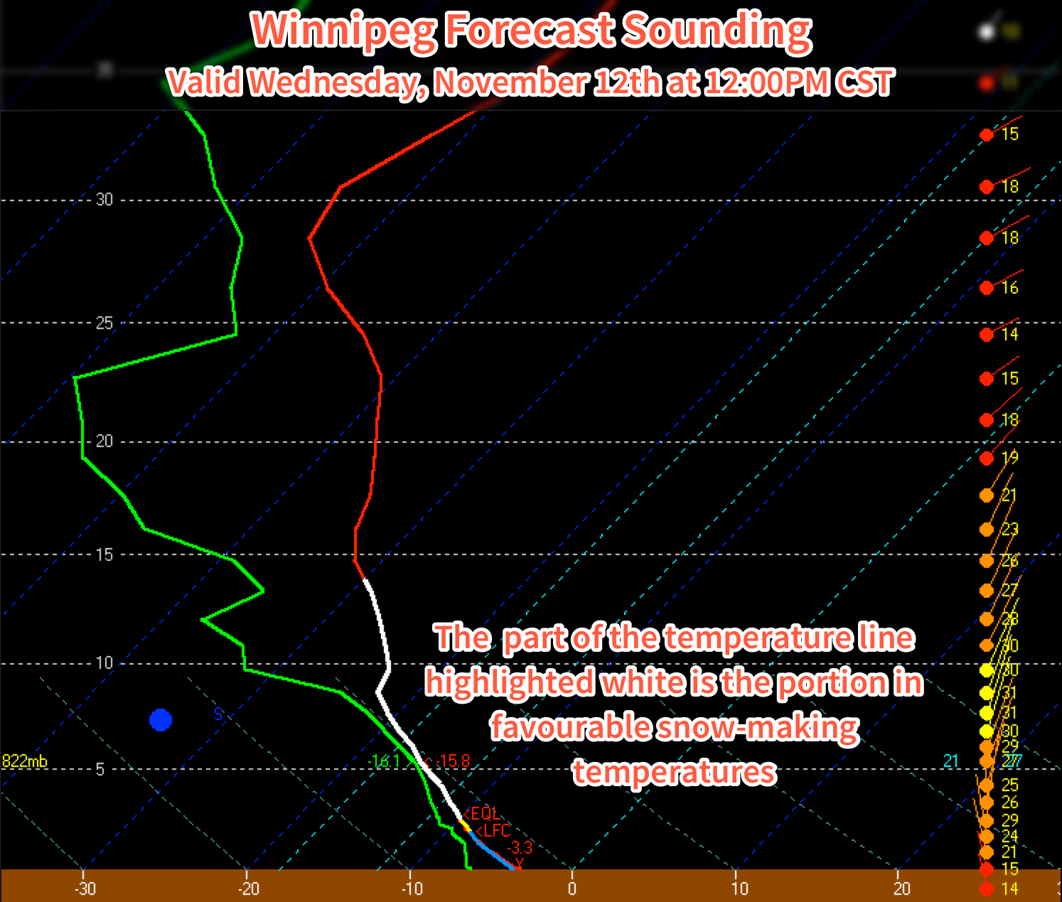
Today will bring mainly cloudy skies with flurries continuing to drift southwards from the Interlake as general instability coupled with optimal temperature profiles[1] results in periods of snow throughout the day today. Snow will begin tapering off in the late afternoon or evening as clouds begin to break up and the northerly winds around 30-40km/h shift more northwesterly and gradually weaken.

Temperatures will climb to a high around -5°C and drop to -9 or -10°C tonight.

The forecast sounding for noon today in Winnipeg shows the deep layer of favourable snow-making temperatures – shown in white – that will be in place Wednesday and Thursday.
The forecast sounding for noon today in Winnipeg shows the deep layer of favourable snow-making temperatures – shown in white – that will be in place Wednesday and Thursday.

Thursday will bring mixed skies as clouds gradually clear throughout the day. The same temperature profile will be in place as today, so any low-level clouds will likely be able to produce some light flurry activity, but nothing significant is expected. Winds will shift to westerly at around 15-25km/h for much of the day as a ridge of high pressure slumps into the Dakotas from Saskatchewan. Expect a low near -14 or -15°C under clear skies on Thursday night.

Friday will be a beautifully sunny day, but it comes with the cost of being the coldest day so far. With relatively light west to southwesterly winds flowing out of the high pressure system to our south and southwest, temperatures will climb only to around -9°C. Temperatures will drop back into the mid-minus teens on Friday night under clear skies.

Cold Weather, Flurries for the Weekend

This weekend looks to bring flurries back to Southern Manitoba as another cold front pushes through on Saturday night. Snow will likely be found along the front as well as behind it through the day on Sunday as another unstable northwesterly flow develops.

The GDPS is showing another round of flurries pushing through the Red River Valley on Saturday night into Sunday morning.

Cold weather is expected to continue behind the front as another shot of Arctic air moves into the province.


  1. Snow grows best in temperatures between around -8°C to -15°C between the surface and around 700mb. The thermal profile over Winnipeg matches those temperatures nearly exactly which will make it very easy for snow to develop.  ↩

Winter’s On The Way

The (seasonally) gorgeous weather we’ve been having to start off November will be coming to an end this weekend as a pool of cold air that’s been dammed up north of 60° spills southwards behind a storm system that will push across the province on Friday. The result will be an abrupt transition from temperatures in the mid-single digits on the warm side of zero to highs well below the normal 2°C. In addition the cooler weather, Southern Manitoba will move into a busier weather pattern that will produce multiple threats for precipitation over the coming week, including what may be our first snowfall that “sticks.” After a quiet 5 weeks, it looks like the weather is set to get much busier in Winnipeg!

Wednesday
3°C / -1°C
Cloudy

Thursday
3°C / -2°C
Mainly cloudy

Friday
4°C / -1°C
Morning snow changing to periods of rain

Before things begin to get busier, Manitobans in the Red River Valley will get another couple days of above-normal temperatures to enjoy. Both today and tomorrow will bring mainly cloudy skies thanks to persistent stratus cloud that will struggle to clear out of the region. A few sunny breaks may show up, but generally cloudy skies will be the common theme. Temperatures will climb to around 3°C for the daytime high today.

Another batch of flurries is expected to move through the Interlake tonight.

Another round of flurry activity is expected tonight as a trough pushes through the region. The overnight low will drop

Thursday will bring a repeat performance for the high, but with a few more clear breaks likely on Thursday night, the low will drop a bit lower to around -2°C. No significant precipitation is expected either day.

Friday: The First Snow?

Friday will mark the start of our transition into a stormier, colder weather pattern. A low pressure system moving from southeastern Saskatchewan into North Dakota will spread an area of snow eastwards into southwest Manitoba on Thursday night, pushing eastwards into the Red River Valley on Friday morning. It looks likely that the precipitation will reach from the American border into the Southern Interlake[1], however the bigger challenge as this system pushes eastwards will be what type of precipitation will be falling out of the sky.

5-10mm of liquid-equivalent precipitation is expected on Friday; how much of that falls as snow remains to be seen.

With a high of just +1°C, it will be a fine line between rain and snow, with a shallow above-freezing layer right at the surface working to try and melt snow as it moves into the lowest levels of the atmosphere. As the morning progresses, warmer air will push in aloft and help snow transition into rain. All in all, it doesn’t seem like a ton of snow will fall; perhaps 2-4cm, however with the switch-over to rain and temperatures climbing above zero, it’s unlikely that it really has much of a chance to accumulate or stick around.

With temperatures hovering near or just above 0°C through the morning, exact timing of rain and snow will remain somewhat uncertain until much closer to this system’s approach.

Temperatures will dip below zero on Friday night as they head to the overnight low of -1°C or -2°C. The freezing temperatures following the rain or snow we see could end up creating quite slippery road conditions, so if you need to travel on Saturday, now’s a great time to brush up on your winter driving skills!

Weekend Brings First Taste of Winter

Behind Friday’s system, significantly cooler air will begin working its way into the province. Temperatures will fall below zero to around -3°C or so for daytime highs and around -8°C[2] for overnight lows. Some lake-effect snow may be possible in the lee of the lakes on Saturday with the cool northwesterly winds moving over the still-open water.

Another low pressure system will move through on Sunday, bringing the first chance for a significant snow event to the Red River Valley. It’s still too far out to try and speculate just how bad it will be, but current model output is showing the potential for anywhere from 10-20cm of snow by Monday morning. It’s still a long ways out, though, and this system could easily end up to our north or south. Consider it added to our storm watch list.

So, with the arrival of winter fairly imminent, enjoy the last couple above-zero days!


  1. There’s a little disagreement with some models suggesting the precipitation remains mainly south of Winnipeg, but at this point it looks like a fairly safe bet that Winnipeg will be impacted by this system.  ↩
  2. …-ish.  ↩

Another Cold Snap in Southern Manitoba

Moderately miserable, categorically cold; the weather leading into this weekend will be fairly miserable as a large low pressure system moving through Ontario exerts its influence over southern Manitoba causing strong northwesterly winds as the coldest shot yet of Arctic air plunges southwards into the United States.

Friday
5°C / -1 to 2°C
Cloudy with showers. Flurries possible in the morning. Strong NW wind to 50km/h.

Saturday
7°C / 0–2°C
Clearing except cloudy in the lee of the lakes

Sunday
9°C / 3°C
Mixed skies with a slight chance of isolated showers or drizzle

Friday: A Miserable Fall Storm

The Red River Valley will be under the grip of a miserable fall storm lifting northwards through Northern Ontario today, driven by a massive push of cold Arctic air sweeping through Manitoba. We’ll see a very cold start to the morning with temperatures hovering around 2–3°C, strong northerly winds at 40–50km/h with gusts as high as 70–75km/h and a band of rain stretching north-south through the region. Embedded within the band will likely be some convection, significant since increased precipitation intensity could mean that in addition to the rain, we might see brief bursts of snow as well.

The precipitation should taper off by early afternoon, but we’ll still be left with a strong northerly wind and temperatures struggling to get to our high of 5°C. If the sun manages to poke out at all, we may eke out a 6°C for a high, but that looks quite unlikely.

The RDPS clearly shows Winnipeg nestled between two bands of lake-effect precipitation on Friday night.

Winds will begin to taper off tonight to around 20km/h. Combined with the cold air, the lake-effect machine will likely start up again, producing lake-effect showers or snow through the overnight period across regions in the lee of the lakes. At this point it looks like Winnipeg will remain safely between the two bands of lake-effect precipitation. The overnight low will be anywhere from –1 to 2°C, depending on exactly how much cloud remains in the area. Here in Winnipeg we should end up on the colder end of things under clearing skies.

A Chilly Weekend

It will be a chilly weekend in Winnipeg with temperatures on Saturday and Sunday both climbing only into the mid-to-upper single digits. Saturday should be a fairly nice day with mainly sunny skies in Winnipeg, but just to our west and east, lake-effect cloud (and likely precipitation) will be ruining a few people’s day. Temperatures will dip to the 0 to 2°C range Saturday night with just a few clouds. Again, lake-effect cloud will be present in the lee of the lakes.

Sunday will bring mixed skies as the whole storm system begins backing into Northern Manitoba from Ontario. Rain or snow will push through Central Manitoba into the Interlake through the day, spreading cloud ahead of it. Winds don’t look too bad this time – only around 20–30km/h – and precipitation should hold off in Winnipeg until overnight. Temperatures will drop to around 3–4°C on Sunday night, heading into a cool and showery Monday.

Spring Storm Incoming

A potent storm system is on the way.

A large spring storm will bring the most significant rainfall to the Red River Valley since last October. It will be mainly rain that falls over the next couple days, however higher-terrain areas of Parkland Manitoba will likely see snow feature more predominantly. This system will be fairly long-lasting, too, with precipitation pushing into SW Manitoba this morning and lingering through Friday.

Wednesday

Wednesday
11°C
Increasing cloud.
Wednesday Night
3°C
Rain beginning in the evening. 5-10mm.

The wet weather over the next couple days is being caused by a strong upper-level trough (depicted in the picture at the top of this post) that is pushing inland from the Pacific. This feature will spawn an elongated trough of low pressure with embedded low pressure centres within it that spans all the way from Alberta through Saskatchewan, Manitoba, and southwards to Texas. This large feature will be aided by an upper-level low tracking along the Canadian/US border which will amplify the precipitation through the Canadian Prairies.

So, what will we see? Rain will spread into southwestern Manitoba this morning and slowly – quite slowly, actually – spread eastwards through the day towards the Red River Valley. By the afternoon, rain should push into the western RRV, but likely won’t reach Winnipeg and into the eastern RRV until late this afternoon or into this evening. By the evening, most areas across Southwest and Parkland Manitoba will likely see around 10-20mm of rainfall, with the potential for some localized amounts of 20-25mm.

Rain will continue to push eastwards through the night, bringing fairly steady rain to most areas in Southern Manitoba. Areas in extreme southwestern Manitoba may see things taper off as the main axis of rain begins shifting to the northeast. Another 5-10mm of rain will fall in most places, however in higher elevations of Parkland Manitoba the rain will switch over to snow overnight with 5-10cm of accumulation possible.

Thursday

Thursday
5°C / 0°C
Rain. 10-20mm.

Thursday will see rain tampering off in Southwest Manitoba, but being reinvigorated over the Red River Valley and Interlake by another shot of moisture lifting northwards along the trough line. Here in the RRV around another 5-10mm will fall, however portions of the valley into the Whiteshell may end up seeing 10-15mm if the heavier rain arrives a little earlier.

Storm-total precipitation expected from Wednesday through Friday.

Light rain will persist through much of Thursday night and perhaps become mixed with snow as we approach our low temperature of around 1°C. Another 2-5mm of precipitation is expected.

Friday

Friday
5°C / -6°C
A few showers or flurries.

The system will finally begin pushing out of the region on Friday, however an lingering trough will hang back into the province for much of the day, spreading some showers or, at times through the morning, light flurries through the region. Further amounts of precipitation will be minimal – likely less than 2mm.

Things look to clear out for a sunny weekend. Saturday’s high will be below normal, somewhere around 6°C or so, and Sunday will return to a near-normal high in the low teens. The nice weather may be short-lived, though, as weather models are hinting towards the development of a Colorado Low that would impact Southern Manitoba starting Sunday night.