Yet another winter storm has affected the US Southeast and eastern seaboard this past week. The low pressure quickly organized just offshore over the warm waters of the Gulf Stream, but at the same time dragging down brisk Arctic air all the way down to the southern states such as Georgia and Alabama. As the low pressure system moved north, just off the coast it quickly became a “meteorological bomb”. A meteorological is defined by a low pressure deepening 24mb in 24 hours, which means deep intensification is occurring. It’s not uncommon to see this occur off the coast in winter because of the large contrast between ocean and land temperature, but is uncommon to see this happen in the middle of the continent.
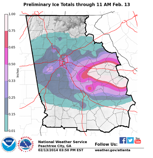
Due to this storm, over 6,000 flights had been cancelled across the eastern seaboard and services totally shut down in the south for 36 hours because of the storm. It appears that the worst damage occurred from Augusta Georgia, westwards, to just south of Atlanta. Here ice accumulation totals approached 2.5cm which made trees and power lines top heavy and eventually collapsing. Snow amounts in the northeast US were also impressive, where snow rates of 10cm/h fell in the heaviest bands. The highest reports were 70cm in South Berne, NY and 61cm in Shrewsbury, VT. Thundersnow was also reported just west of New York City as multi-cell thunderstorm clusters drifted north of the warm front and transitioned to snow producers.
Ice accumulation with the latest winter storm affecting Georgia. (Source: NWS Atlanta)
Residents should not put their shovels away quite yet though as a strong low off the coast is expected in the Wednesday-Thursday timeframe next week which will be another big weather producer for the East Coast.
Southern Manitoba will finally see a reprieve from the icy grip of winter as a major pattern change will allow Pacific air to wash over the Prairies bringing substantially warmer – and more unsettled – weather.
Friday
-17°C / -20°C
Mainly cloudy. Chance of flurries this evening & overnight.
Saturday
-14°C / -23°C
Mainly cloudy; chance of morning flurries.
Sunday
-9°C / ⇒ -9°C
Strong winds with blowing snow. Chance of snow late day.
A Couple Cool Days
There will be a chance to dig out after Wednesday night’s storm dumped around 10-15cm through most areas in Southern Manitoba as cool, fairly benign weather settles in over the Red River Valley for the next couple days. Mainly cloudy skies will persist through much of the day today as we climb to a high of only around -17°C.
As shown by the RDPS imagery above, flurries are possible tonight (light blue) over much of Southern Manitoba.
A weak disturbance will push through tonight that will push some light snow through the Interlake, but further south in Winnipeg & the Red River Valley there will be just a chance for some flurry activity. The relative weakness of the disturbance combined with quite cool temperatures will ensure that if anything manages to develop it will be quite light and not really accumulate to much at all. We’ll remain cloudy through the night and drop to a low around -20°C.
Saturday will be a fairly quiet day with any possible flurry activity tapering off in the morning and then seeing clouds slowly try to break up through the day. Some clearing should work it’s way in later in the day, but it’s a little uncertain how clear we’ll get. While it will have little bearing on any significant weather, it will dramatically affect our overnight low. If we remain a little cloudier – which I’m thinking is the more likely outcome – we’ll see an overnight low of around -23 or -24°C. If the clouds manage to clear out, even for a couple hours, we’ll get quite a bit colder than that and possibly see another low dipping below -30°C. That marks the last day of cold, though, as a major pattern change begins on Sunday.
Wind and Blowing Snow Usher in Warmer Weather
Sunday will mark the beginning of a major pattern shift that will see the persistent trough that’s been anchored over Northwestern Ontario break down and push off to the east, allowing our upper-level northwesterly flow to be replaced by westerly flow. That sounds like a small shift, but the impact will be dramatic.
Sunday will see increasing cloud through the day as milder air finally pushes in from the west. By evening our temperature will rise to around -10°C and snow will be pushing into Southwestern Manitoba. There will likely be at least some flurry activity, if not some light snow on Sunday night as a warm front pushes across the Red River Valley, but accumulations – at this point – look minimal.
The forecast sounding for Winnipeg on Sunday evening shows very strong low-level winds.
Perhaps the biggest weather impact on Sunday will be the southerly winds that will develop through the Red River Valley ahead of the warm front. A tight pressure gradient will result in strong winds developing fairly early in the day. We’ll likely see winds climb to around 50km/h sustained which will undoubtedly produce localized white-out/blizzard conditions in the Red River Valley. It’s too early to say exactly how bad it’s going to be, but it seems fairly certain that blowing snow is going to be a big issue for anyone planning to travel on Sunday, especially in the evening hours when the strong winds may combine with falling snow.
After we make it through the cold weather’s last stand, a significantly warmer – and more unsettled – week is ahead of us as the westerly flow aloft establishes itself over the Prairies. Daytime highs next week look to sit around -4°C, plus or minus a few degrees, but with the warmer weather will come multiple chances for snow as a train of disturbances set up and track across the Prairies. At this point, however, I’ll gladly take more snow if it means a break from the relentless cold we’ve seen in Winnipeg this winter.
More snow is on the way for Winnipeg and the Red River Valley as a fairly strong low pressure system tracks through North Dakota and spreads snow through much of Southern Manitoba. The upside to the snow is that rather than plummeting into another deep freeze, this system will actually mark the start of a notable warming trend for Southern Manitoba!
Wednesday
-17°C / -19°C
Increasing cloud; snow beginning early in the evening. 10-15cm overnight.
Thursday
-16°C / -23°C
Occasional sunny breaks with a chance of flurries.
Friday
-18°C / -21°C
Mainly sunny.
Significant Snowfall Tonight
While today may bring mainly sunny skies through much of the day, a low pressure system set to bring a fair amount of snow is on it’s way. Temperatures will warm up to around -19°C before cloud starts streaming in from the west later in the afternoon. There’s a decent chance we’ll see some light snow through the evening, but the main shot of snow will arrive through the overnight period.
Forecast storm-total snowfall amounts by Thursday morning. Updated image; original forecast is here.
Conditions will deteriorate from west to east through the evening as heavier snow pushes into the province. In general, between 5-10cm of snow can be expected for all areas along and south of a line running approximately from Dauphin to Gimli to Pinawa, however there are two primary areas of concern I have for higher amounts:
Patchy areas of very heavy snow. Several models are indicating extremely strong lift associated with this system. While the moisture supply isn’t astonishing, there’s certainly enough for me to be concerned about some embedded areas of very heavy snowfall. It’s impossible to say where these might occur at this time, but be aware that there is the potential for snow to rapidly accumulate should some of these heavier bursts of snow develop. Of course, the heavy snow would also produce near-zero visibilities, so if you need to drive overnight, be prepared for poor conditions.
Higher amounts near the western escarpment of the Red River Valley. With the low pressure centre tracking far to our south, we’ll primarily see easterly and north-easterly winds through much of the event. These are favourable directions for upslope enhancement along the western escarpment of the RRV. This is a more predictable feature, and I feel comfortable saying that areas near the escarpment will see closer to 10cm, perhaps as much as 15cm if the winds align just right. The winds will shift to northerly very early on Thursday morning, so the threat will have limited time to work.
Here in Winnipeg we’ll most likely see around 10-12cm by the time all is said and done, assuming the track of the low doesn’t dramatically shift southwards. Although winds may get a little gusty this afternoon, it should be relatively light through the snowfall event itself at only around 20-30km/h. Snow will taper overnight in southwestern Manitoba and early tomorrow morning here in the Red River Valley.
A Couple Cool Days as Pattern Shifts
Thursday will bring mainly cloudy skies, although we’ll see a few sunny breaks through the day. There will be a good chance of some light flurries through much of the day and into the evening. No real accumulations should come of them, though. We’ll see a high near -16°C thanks to all the cloud followed by a low near -23°C with clearing skies overnight.
Friday will be mainly sunny and cool with a high of only around -18°C. We’ll drop down to a low near -21°C on Friday night with a few clouds pushing in.
Weekend Marks Beginning of Warm-Up
This weekend will bring warmer temperatures as a westerly flow develops aloft and brings milder Pacific air into the region. Saturday looks to bring mixed skies as an Alberta Clipper scoots through extreme SW Manitoba and North Dakota. It looks like our temperature will climb to around -13°C or so. Sunday looks to be mainly cloudy as Pacific air continues to wash over the Prairies. Models are hinting at a storm system that might bring us another batch of snow on Sunday night, but we’ll leave that one until we’re closer to the event.
Temperatures look to climb above -10°C on Sunday and close to -5°C on Monday. Better yet, it looks like the warm-up may actually be here to stay for a while!
This week will see the return of snow, something we’ve been virtually immune from over the last couple weeks. However, before we can get to the white stuff, we’ll have to deal with another day of extreme cold.
A low pressure system will bring snow to southern Manitoba on Tuesday.
Monday
Monday
-20°C / -28°C
Mainly Sunny
Today will be another day of extremely cold weather. Temperatures this morning were in the -30s and daytime highs this afternoon will remain near -20°C. We’ll be under the influence of a high pressure system today, which will at least keep wind speeds light.
Tuesday
Tuesday
-12°C / -23°C
Snow
Tuesday will bring our first chance of snow in quite awhile. Morning temperatures will be very cold once again, but an approaching low pressure system will help bring in warmer temperatures by late in the afternoon. This system looks to bring 2-5cm to Southern Manitoba during the day on Tuesday. As the system departs on Tuesday night, the wind will come up a bit, generating some blowing and drifting snow.
Wednesday
Wednesday
-16°C / -18°C
Mainly Sunny
Wednesday will be a transition day as we move from one weather system to the next. It will be a fairly benign day in general, with temperatures in the mid minus teens and light winds. Although that will change late in the day as current forecasts suggest we’ll see another chance of snow late on Wednesday into Thursday. More details on this will be available as the week progresses.
Long Range
The long range forecast continues to show glimpses of hope that we may begin to warm up. Models have been hinting at warmer weather for the end of February, so we’ll just have to wait and see if that pans out.


