This week will see the return of snow, something we’ve been virtually immune from over the last couple weeks. However, before we can get to the white stuff, we’ll have to deal with another day of extreme cold.
A low pressure system will bring snow to southern Manitoba on Tuesday.
Monday
Monday
-20°C / -28°C
Mainly Sunny
Today will be another day of extremely cold weather. Temperatures this morning were in the -30s and daytime highs this afternoon will remain near -20°C. We’ll be under the influence of a high pressure system today, which will at least keep wind speeds light.
Tuesday
Tuesday
-12°C / -23°C
Snow
Tuesday will bring our first chance of snow in quite awhile. Morning temperatures will be very cold once again, but an approaching low pressure system will help bring in warmer temperatures by late in the afternoon. This system looks to bring 2-5cm to Southern Manitoba during the day on Tuesday. As the system departs on Tuesday night, the wind will come up a bit, generating some blowing and drifting snow.
Wednesday
Wednesday
-16°C / -18°C
Mainly Sunny
Wednesday will be a transition day as we move from one weather system to the next. It will be a fairly benign day in general, with temperatures in the mid minus teens and light winds. Although that will change late in the day as current forecasts suggest we’ll see another chance of snow late on Wednesday into Thursday. More details on this will be available as the week progresses.
Long Range
The long range forecast continues to show glimpses of hope that we may begin to warm up. Models have been hinting at warmer weather for the end of February, so we’ll just have to wait and see if that pans out.
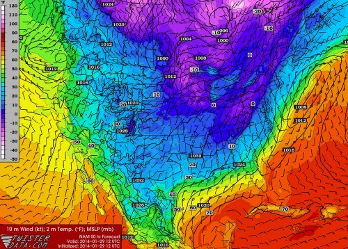
On Tuesday a large trough was in place over the eastern half of the US. The longwave trough extended all the way down to the southeastern states and brought adverse weather conditions along with it. This trough did not produce the typical severe weather the southeast would see around this time of the year; thunderstorms and flooding rain, but produced an event featuring snow, ice pellets and freezing rain.
Arctic air flooded in behind the cold front all the way down from Texas to the Gulf of Mexico to Florida, providing good environment for freezing precipitation right behind the front. Freezing rain fell as far south as Pensacola in the Florida panhandle where over 200km of interstate had to be shut down because it was deemed to be too dangerous for travel. The last time Pensacola saw snow was 2010 – it melted the same day it fell. In comparison, Atlanta saw a trace of snow in 2008. This time around the city received 6cm, which snarled traffic on the commute back home. Officials decided to not cancel schools and students were stranded in schools and buses overnight until the next morning. Commuters were in the same situation, being stranded on roads overnight as many commuters are not accustomed to winter weather leading to many accidents. The sub-freezing temperatures across the Deep South also wreaked havoc, bursting water pipes above ground.
Wednesday morning surface temperatures. Freezing temperatures can be seen reaching all the way down into Mexico and the Deep South. (Source: Twisterdata)
Medium range models continue to show cold air entrenched across the Canadian Prairies and most of the United States, even infiltrating into the Deep South again next week. A persistent ridge off the West Coast, partially associated with the well above normal temperatures in the North Pacific, can be blamed for the persistent troughing and Arctic air over Canada and US the past few weeks. Longer range models do show the ridge eventually breaking down in a week but this remains to be seen as it’s still a long ways out.
Take heart and treasure the mild weather we have this morning; the Arctic cold front is on it’s way and through a series of low pressure systems we’ll see a snowy couple days drag us back into the icy grip of winter.
Friday
3°C ⇘ -12°C / -25°C
Light snow beginning midday. 2-4cm. Clearing & windy in the afternoon.
Saturday
-17°C / -24°C
Increasing cloud in the afternoon; snow overnight.
Sunday
-19°C / -30°C
Risk of a blizzard. Snow ending midday. Windy.
Mild Weather Forced Out
Our daytime high will not happen this afternoon. In fact, it will be roughly around where we are at the time of this being posted; an expected high temperature of -3°C sits only a couple degrees above where we are at right now and then we’ll see temperatures start going the wrong way behind a cold front set to push through midday.
We may see a few flurries this morning but the more organized precipitation will hold off until midday when a cold front begins working it’s way southwards. Complicating things will be an upper level shortwave that is rippling down in a northwest flow will ride along the frontal boundary and provide additional lift, helping make snow a little more widespread than it would be otherwise. Due to that, most areas across Southern Manitoba will see some snow through midday as everything passes through. Significant amounts are not expected as mid-level moisture will be somewhat lacking and limit the amount of snow that can be produced. In general, around 2-3cm will be seen in many areas. There’s a slight chance we’ll see a little more in the southwest Red River Valley – near Morden, Winkler, Altona & Gretna – thanks to a closer proximity to the upper-level shortwave and a little more mid-level moisture. Even there, though, I don’t expect to see more than 4 or 5cm.
The snow will taper off this afternoon and stronger northerly winds will develop to around 30 gusting 50km/h. Some local blowing snow might develop through the afternoon, but it shouldn’t be a widespread issue. Temperatures will begin tanking as the northerly wind ushers in cooler Arctic air, but fortunately the big cool-off will hold off a couple more days. Temperatures should drop through the afternoon to somewhere between -10 to -15°C by evening and then onwards to an overnight low close to -26°C or so under clear skies and diminishing winds.
A Cool, Calm Day
GDPS 850mb temperature forecast for Saturday showing a strong baroclinic zone through the Prairies.
Saturday will bring fairly benign weather and act as our calm before the storm. A cold, sunny start to the day will go on to see a high around -17°C under increasing cloudiness as a compact but powerful system zips towards the province along a strong baroclinic zone. A few flurries are possible anywhere there’s cloud, but the organized snow will push into Western Manitoba midday and work it’s way towards the Red River Valley by evening. Around 5cm will fall over Western Manitoba while just 2-4cm are expected here in the valley with the potential for some higher amounts along the western escarpment thanks to an upslope flow that will develop overnight.
Winds will remain fairly light throughout the day and night. Flurries will persist until Sunday morning and we’ll drop to an overnight low of around -24°C.
Miserable Weather for Sunday
The NAM (among others) is forecasting a strong pressure gradient over Southern Manitoba on Sunday.
The big story behind the departing low pressure system on Sunday will be the absolutely massive Arctic ridge racing into the Prairies behind it. A very strong pressure gradient is set to develop over Southern Manitoba which will produce strong winds. At this point, it looks like winds will steadily increase early Sunday morning to 40 gusting 60km/h in most places. Through the southern Red River Valley winds will likely climb into the 50-60km/h range thanks to the funnelling effect of the terrain.
Anyone with highway travel plans for Sunday should keep updated on the weather conditions and be prepared for potentially hazardous weather conditions with near-zero visibility on highways.
These strong winds, combined with instability in the low-levels thanks to more cold air pushing southwards and the fresh snow of the past couple days will very likely produce widespread blowing snow. It does look like a blizzard may be possible, although things may end up being a little too marginal. For a blizzard on the Prairies, Environment Canada requires:
Winds of at least 40km/h or greater.
Visibilities of 1/4SM (400m) or less in blowing snow or blowing snow with falling snow.
Both (1) and (2) lasting for 4 hours or more.
The best chance for blizzard conditions will be south of Winnipeg in the Red River Valley and southwards into North Dakota. A strong pressure gradient coupled with ample fresh snow and the funnelling effect of the valley will likely make it quite easy to go down to near-zero visibility. For most other regions, a blowing snow warning seems very possible[1]. Either way, highway travel will likely be poor-to-closed on Sunday. We’ll keep an eye on this as it develops and provide updates a little later this weekend on how things look to be shaping up for Sunday.
Other than the winds, we’ll see skies clear out through the day and our temperature remain steady from Saturday’s low or dropping slightly. The winds will taper off in the late afternoon and we’ll head to a low near -30°C.
Blizzard Update
Right now it looks like this may be the most significant ground blizzard of the winter so far.
Everything seems to be fairly lined up for a significant blizzard event to develop overnight tonight. Winds will begin to pick up through SW Manitoba late overnight and slowly spread eastwards towards the Red River Valley by midday. At this point, it seems like widespread winds of 40-50km/h are possible, although it is possible the winds strengthen as high as 50-60km/h in some areas. Gusts to 70-80km/h are quite likely throughout much of Southern Manitoba.
Widespread blowing snow is expected on Sunday. Maximum blizzard potential exists through SW Manitoba, the western Red River Valley and southwards into North Dakota.
These strong winds will work in tandem with fairly deep low-level instability and a surprising amount of moisture to make very favourable conditions for blowing snow. The strong winds will persist for at least 6-9 hours in most places, making a long-term blowing snow or blizzard event quite likely. If you have any plans to travel on highways in Southwest Manitoba or the Red River Valley on Sunday, it is best to give yourself ample time & make alternate arrangements; white-out conditions are very likely and some highways may be closed. Right now it looks like this may be the most significant ground blizzard of the winter so far.
This blizzard event will extend all the way southwards into North Dakota where there is absolutely no question that a significant ground blizzard will be underway. Just to repeat, conditions will get worse as one travels south. Winds will begin to ease and let conditions improve from north to south through the evening hours.
All in all it will be a lousy day for highway travel. Don’t do it if you don’t have to and stay safe.
Like a blizzard warning, but only requires 1/2SM visibility (800m) and 3 hour duration. ↩
Residents in the Red River Valley have barely had time to get the shovels out after Wednesday’s snowfall and Thursday’s blowing snow/blizzard, but more snow and wind is on the way as another system tracks through today. The unsettled weather will continue through the weekend with a brief improvement on Saturday followed by more unsettled weather on Sunday.
Friday
-8°C / -10°C
Increasing cloud in the afternoon then snow. 4-8cm accumulation.
Saturday
-7°C / -9°C
A mix of sun and cloud. Blowing snow in the morning. Chance of flurries.
Sunday
-5°C / -20°C
Light snow developing through the day.
Another Shot of Snow Tonight
More snow is on the way later today through tonight as another low pressure system dives southeastwards through the province. Before that, though, we’ll see mainly sunny skies with relatively light winds out of the south at only around 20-30km/h by the afternoon. The temperature should climb up to around -8°C in Winnipeg while areas closer to the U.S. border may see the temperature get as high as -5°C or so.
Expected storm-total snowfall amounts by Saturday morning.
Cloud and snow will stream in fairly quickly from the northwest later this afternoon as the low pressure system begins slumping southwards through the Interlake. The heaviest snowfall will fall before midnight with lighter flurries persisting thereafter into the early morning. The snow will taper off by tomorrow morning with totals generally between 4-8cm through Winnipeg & most of the Red River Valley.
Blizzard conditions may develop in the southwestern Red River Valley thanks to the funnelling effect of the western escarpment.
Winds won’t be as strong as Wednesday through the snowfall event – around 30km/h gusting to 50 or so in Winnipeg and the eastern Red River Valley and a little bit stronger in the western Red River Valley at around 40 gusting 60km/h. There will be some blowing snow through the overnight period, but I don’t think we’ll see anything as extensive as on Wednesday night into Thursday. The one caveat may be the southwestern Red River Valley[1] where blizzard conditions may develop thanks to a funnelling effect of the western escarpment. Winds may climb up to 50 gusting 70km/h which should be enough to produce a widespread white-out. The strong winds will move in overnight and taper off midday tomorrow.
Nice Start to Weekend, Snowy End
Skies will clear out early Saturday morning with any blowing snow hanging on a little longer until the winds die down. Otherwise we’ll see mixed skies with a high near -7°C with fairly light winds. There will be a slight chance of a flurry or two, but no accumulations are expected.
We’ll drop to an overnight low of just -9°C[2] as more cloud cover begins working it’s way in ahead of another disturbance on it’s way. There will be a continued chance for some isolated flurries overnight.
Sunday will be a mainly cloudy day with snow developing through the afternoon. We’ll climb up to a high of around -5°C. The snow will taper off through the evening on Sunday with some breezy northerly winds producing some blowing snow through the Red River Valley. At this point it doesn’t look too bad, fortunately. Skies will clear Sunday night and we’ll drop to an overnight low of around -20°C.
We’ll continue on an unsettled track through next week as very cold Arctic air begins pushing it’s way back into the region. It seems like we’ll be seeing overnight lows near -30 to -35°C in the latter half of the week, so enjoy the upcoming mild weather!
Areas near Carman, Altona, Winkler, Morden, and Emerson are most likely. ↩
An overnight low that’s warmer than our normal daytime high for January 17th! ↩