Elsewhere in Weather News: April 20th, 2013

Major Trough Moves through US

A trough of low pressure moving across a large swath of continental United States this week has been the cause for severe flash flooding, much wind damage, and a few tornadoes including Canada’s first of the year.

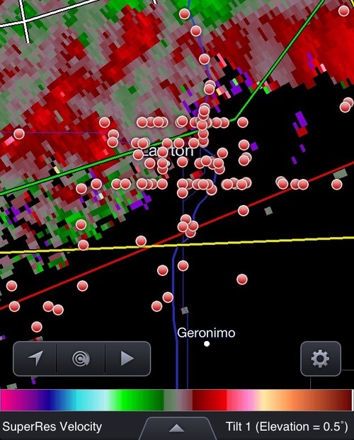
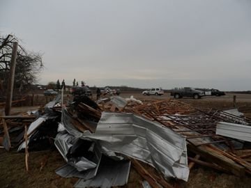
The first severe weather day occurred on Wednesday, April 17th, when a moderate risk was issued by the SPC for most of Oklahoma, parts of south-west Kansas and Missouri. Over 150 chasers (reporting) were scattered throughout Oklahoma, and at one time over 50 chasers could be seen on the same supercell! Severe thunderstorms fired along the warm front and further along the dryline that extended into Texas in early afternoon. The storms that had the largest tornado potential went up in south-western Oklahoma and moved towards the north-east. These storms along the warm front trailed each other and produced flash flooding in some localities. Also to note is that a few cities such as Lawton, OK who were lying along the warm front saw not one supercell that day, but three within four hours. One of these also dropped a tornado which caused some damage to an industrial area on the outskirts of the town.

Chasers

Incredible chaser convergence (red dots) in Lawton ahead of a supercell. Just about every single street in Lawton had a chaser on it! (Source: Spotter Network/RadarScope)

On Thursday and Friday the trough continued its push eastward, but it became less of a tornado threat and more of a severe wind and hail event. At one time, thunderstorms stretching from Ontario all the way down to Texas could be seen. A few states such as Illinois, Iowa, Alabama, and Missouri saw extremely heavy rain in a short period of time which was cause for flash flooding concerns. Air rescues took place in Oxford, Alabama to save stranded motorists caught in their partly submerged cars. Canada’s first tornado of 2013 was also recorded on Thursday, rated as an EF 1 it touched down near Melanchton, Ontario.

Tornado damage

Damage of a barn in Southern Ontario from the EF 1 tornado. (Source: Steve Murphy EMC via Caledon Enterprise)

The cooler weather is not expected to last this weekend as return flow sets up and southerly winds kick in for most of the Plains and Midwest. Later next week it appears as though yet another high pressure will slide down the Rockies, in turn bringing more unseasonably cold air to the Central United States.

Elsewhere in Weather News: March 23rd, 2013

Damaging Tornadoes Touch Down Across the World

Tornadic activity was experienced across the globe this past week, affecting countries from Bangladesh to Australia and even China.

Australian tornado

Capture of the Doppler Radar velocity at the time of the tornado (area of dark blue vs. red). (Source: BoM/ @vicstormchasers)

In Australia on March 21st , at least two powerful tornadoes touched down on the border of Victoria and New South Wales, ripping through more than a half-dozen towns lying along the Murray River. The strongest twister, with an estimated F2 rating on the Fujita scale, caused major damage to the towns it swept through – tearing roofs off their structures, throwing cars around and snapping power lines. In total, 20 people were injured and two had to be airlifted to hospital. Thankfully no deaths were associated with this tornado outbreak. A deep low pressure system responsible for spawning these tornadoes lay just off Tasmanian coast with a cold front stretching up into Australia.

Video of the Australian tornado dangerously close up. Power flashes and debris can clearly be seen flying through the air. (Source: Daniel Clarke)

The tornado that touched down in Bangladesh on Friday, March 22nd also caused a fair amount of damage to a few rural eastern Bangladesh towns. The twister was on the ground for about 15 minutes but it is not yet known what the strength of the tornado was estimated to be. At least 100 injuries and 20 deaths were reported as a result of this tornado.

The people of Bangladesh are more susceptible to injury and death from tornadoes since finding a safe haven from them is not as easy as heading down to a basement to take cover. Most houses in the area are built out of mud and don’t have a sturdy structure, making it difficult to escape when residents find themselves in the path of a twister. Tornadoes are common in Bangladesh from March to late April before they transition into the monsoon season.

Guangdong, a southern province of China, was also in the crosshairs of severe weather this week. A supercell produced egg size hail accompanied with a tornado that made its way through the city of Dongguan (pop. 400,000). Significant damage occurred – many buildings collapsed and the storm even overturned a ferry offshore. These Chinese storms were the deadliest storms of the week, accounting for 24 deaths and over 200 injuries.

China egg-size hail

Hail the size of eggs covers the ground in Dongguan, China. (Souce: I.B. Times)

Elsewhere in Weather News: February 16th, 2013

Tornado Hits Hattiesburg, MS

The Deep South in the United States experienced another round of severe weather this past Sunday as gulf flow brought moisture and other crucial ingredients –such as vertical wind shear and forcing– to the area, creating ideal conditions for the spawning if tornadic supercells.

The tornado that occurred late Sunday afternoon and travelled through Hattiesburg Mississippi (population 51,000) was the strongest tornado of the outbreak (total of 14 tornadoes) and caused the most damage. Rated as a low-end EF-4, the Hattiesburg Tornado made its way through the north-west side of the city. It tore off roofs, took down brick walls, and caused damage to the south end of the University Southern Mississippi campus. Two dozen injuries were reported and no fatalities occurred with this tornado, thanks in part to quick warnings issued by the NWS citing that there was a confirmed tornado heading towards the city.

Video of the Hattiesburg, MS tornado as it passed through the north-west part of town. (Source: Youtube – tarah106)

With these additional 14 tornadoes, the United States is running slightly above their tornado average of 73, with a current count of 103 tornadoes. All 103 tornadoes occurred in the Southern and Midwest US. What remains to be seen is how the peak tornado season will play out in April/May in Tornado Alley where they are currently experiencing significant drought. The lack of moisture in that area could impact the season’s typical storm activity.

NOAA graph

US (inflation adjusted) tornado percentile ranks, created by NOAA – SPC. (Source: NOAA)

Elsewhere, there has not been much extreme weather other than more hot temperatures for Australia and a weakening tropical cyclone Indian Ocean (Gino) which managed to reach category two earlier this week.

Elsewhere in Weather News: December 8th, 2012

Typhoon Bopha Makes Landfall

(Follow-up to last week’s EIWN article “Typhoon Bopha Takes Aim at the Philippines”)

Typhoon Bopha made landfall on Monday, December 3rd, on the southernmost island of the Philippines. The typhoon was classified as a dangerous category five, where winds exceeded 250km/h. As expected with category five typhoons, the devastation and destruction caused extensive damage to infrastructure and crops; one fourth of the banana crops in the region were destroyed. As of Friday, December7th, it was reported that over 500 people had died as a result of the storm, and about 350 were still missing. Rescue workers are working feverishly, looking for survivors assumed to be trapped in their houses because of mudslides, or gold miners trapped in mines. In total, Bopha displaced about 250,000 Philippine residents who mostly took shelter in public buildings to ride out the storm. The Red Cross is providing funds and food to the ravaged country. Bopha appears to be the strongest, southernmost typhoon on record, to have ever affected this region of the Philippines.

Bopha

Infra-red satellite image of Bopha on Friday evening. It does not have a distinct eye and is showing signs of weakening. Forecast track is in white. (Source: CIMSS)

After Bopha made landfall in the Philippines, it emerged into the South China Sea and has re-strengthened to a category three hurricane with a well-defined eye. Its track has taken a northerly direction which was followed by a north-easterly track, which means its outer bands will affect the north-west islands of the Philippines later this weekend. Bopha will continue its somewhat circular track and is predicted to eventually head out in a south-westerly manner towards Vietnam next week. There is a lot of uncertainty as to what will happen after that, but there are some signs that show the storm will weaken off to a tropical depression.

Damage

Incredible damage in New Bataan, a southern Philippine city. (Source: AFP)

In other news, New Zealand experienced its deadliest tornado on record this past week where an EF-2 struck a suburb of Auckland and killed three people. It’s not a common sight to see such a strong tornado in Auckland but the conditions on December 6th greatly contributed to this, as warm, humid air, fueled severe thunderstorms in that area.

Short collection of videos of what it was like being inside the New Zealand Tornado. (Source: AP)