Elsewhere in Weather News: July 27th, 2013

France Faces Severe Storms; More Coming Today

France has had its fair share of severe storms this past week, with more of it expected to come today (Saturday). A level 3 “severe” thunderstorm, the highest risk possible, has been issued by ESTOFEX (European Storm Forecast Experiment) for the northern half of France. Conditions are favorable for tornadoes with a warm front draped across the region and incoming cold front from the west; an upper-level low spinning off the coast of France over the Atlantic will provide sufficient destabilization in the upper levels of the atmosphere.

ESTOFEX forecast

ESTOFEX forecast for today, risk 3 in northern France, Belgium, Netherlands and northwest Germany. Highest risk for large tornadoes resides here. (Source: ESTOFEX)

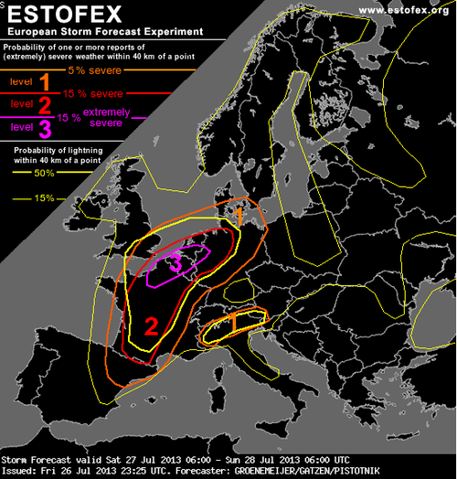
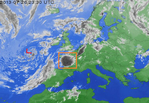
The only potential flaw in the setup could be due to the large MCS that fired up on Friday evening in west-central France as it continues to move northeast potentially leaving debris cloud in the region this morning. But with that said, as of Friday evening, the MCS was moving fairly quickly, and at this rate would be out of the region in time for tomorrow’s setup. With dewpoints in the low twenty Celsius range, shear plentiful with the approaching upper-level trough, and a great shear profile, all kinds of severe weather could be in play, including powerful tornadoes. The severe weather risk also extends into northwest Germany, Belgium and the Netherlands.

MCS and upper level low

Upper level low spinning off the coast of France and MCS in orange box that could hinder storm activity tomorrow. Infrared satellite image taken Friday evening. (Infrared satellite image source: Weather Online)

The expected severe weather follows a significant weather outbreak that occurred in France on Tuesday afternoon. Strong storms passed through the Burgundy region dropping large hail (between ping-pong and golf ball size) and causing significant damage to vineyards. In this region, crop losses are as much as 75% in the hardest hit areas. Flooding was also an issue, where some main roads such as the one between Pommard and Volnay were flooded out and impassable.

In 2008 an EF-4 tornado touched down around Hautmont, France and caused 4 fatalities and 18 injuries. Severe weather is not that common of an occurrence in France, with only a couple outbreaks per year.

Elsewhere in Weather News: May 25th, 2013

Powerful Tornado Devastates Moore, Oklahoma

As you may have heard through media reports these past few days, Oklahoma was subject to severe tornadic weather this week which resulted in catastrophic and tragic consequences for many. Supercells posed a threat to residents as they dropped a number of large tornadoes – including a historical tornado that struck Moore on Monday, May 20th. A longwave trough (same as talked about in last week’s EIWN) was in place on the west coast as were other factors that made the conditions ripe for strong, long tracked tornadoes.

Moore tornado

Supercell with hook echo and large debris ball (just west of Moore), May 20th, 2013. (Source: UCSB)

Moore, with a population of over 50,000, is located in the heart of Tornado Alley and has been struck directly by tornadoes 3 times in the past 15 years. The fact that they are situated where moist air comes in from the Gulf of Mexico and where a source of dry air from the south-west US not too far away, causes many dryline setups in mid-late spring – ideal conditions for triggering storms.

On May 20th, storm cells fired up early in the afternoon and quickly became supercellular and well organized with rotation. As the supercell approached the Moore area, a hook echo formed and not long after, a debris ball could be seen on radar just before it was passed over Moore – it was obvious that Moore was in dire trouble and a tornado had touched down. Thankfully, the National Weather Service in Norman provided generous lead time of 16 minutes before the tornado entered Moore, certainly saving many lives.

Moore damage

Aerial view of the damage in Moore. (Source: AOL)

Tragically however, even though advance warnings were given, 24 people perished that day. In some areas it was not possible to take refuge in interior rooms; EF-5 winds easily ripped apart any building in the tornado’s path. Damages are estimated to be in the billions of dollars with an estimated 1,300 homes destroyed and countless number of vehicles wrecked.

Incredible video of a close up view of the 2013 Moore tornado, not to be tried at home – very dangerous! (Source: Jeffery Lechus/Youtube)

It appears the storm track will remain active with troughing across the western part of the continent and intermittent shortwaves rounding down the ridge across Southern US. Severe weather looks likely in the High Plains region of the US (Nebraska, Kansas) in the coming week – not out of the ordinary for these locations at this time of the year.

Elsewhere in Weather News: May 4th, 2013

Let it Snow!

Record-setting snowstorms were the topic of conversation in parts of the US this week.

Snowfall reports

Snowfall map until Thursday morning. (Source: NOAA)

Springtime weather was delayed once again as a significant trough moved across Central US dragging down unseasonably cold arctic air with it. Friday morning, temperatures at 850mb reached below freezing all the way down to Mexico; and snow fell from Northern Ontario all the way down to northern parts of Arkansas and Oklahoma! Many snowfall records were shattered, some of the most significant being:

  • Britt, Iowa – Achieved a snow depth of 28cm, beating the old record of 25cm (in 1947).
  • Chippewa-Falls/Eau Claire, Wisconsin – Recorded a snowfall of 22cm shattering the old record of 5cm (in 1946).
  • Extreme north-west Wisconsin – Recorded a snowfall of 46cm.

The trough will not make it to the East Coast as the main jet stream is retreating north and a cutoff low will form in southern US. This cutoff low is expected to slowly drift across the region feeding into tropical moisture while dropping significant rainfall over parts of the south-east and east-central US. Accumulations of over 80mm are expected, increasing concerns that flash floods might be a problem over the weekend.

In other news, a category one cyclone formed off the north-eastern coast of Australia, however it had minimal impacts on land as it fizzled out and only brought lowland flooding and erosion to coastal areas.

Italy also saw an active week with a large tornado reported in it’s northern region. An approaching shortwave combined with significant instability and sufficient shear on Friday was the cause for severe storms in the area.

Short video of the Italian tornado as seen from the nearby city of Castelfranco Emilia. (Source: R. Melotti)

Elsewhere in Weather News: April 27th, 2013

Fairly Calm Week

It has been relatively quiet weather-wise across the globe this week with no significant events affecting heavily populated areas. However, there were still some extreme weather events that took place, although more localized.

This past Thursday, a cold front pushing south across Hong Kong and parts of south-east China dropped excessive amounts of rainfall, triggering flood concerns. The front had significant warm and moist air to work with as it slowly moved south towards the South China Sea. Several reports came in from south-eastern China showing 50mm of rain in a 24 hour period, concerning residents of increased flood risk this weekend and into next week thanks to another low pressure through making its way into the region.

In other news, isolated severe storms pushed through the state of Louisiana Wednesday. The long cold front extended from Southern Ontario all the way down to Louisiana; where dynamics were most favorable for severe storms midday Wednesday. A weak tornado even touched down in Keeling, a suburb of New Orleans, causing power outages and downing trees. After the storms moved through, 32,000 people in the area were left without power, but it has since been restored. There is a chance for more severe weather in the same area on Sunday and severe weather in the Plains region early next week. Following those events, there isn’t any indication of severe weather until at least next weekend as moisture gets flushed out. What comes after that remains to be seen as there is much uncertainty between weather models.

Dewpoints

Surface dewpoints (in Fahrenheit) Wednesday morning. Cold front is clearly visible and the circled area ahead of the front in Louisiana had the highest tornado potential. (Source: Twisterdata)