State of the Climate – A Stormy Summer 2016

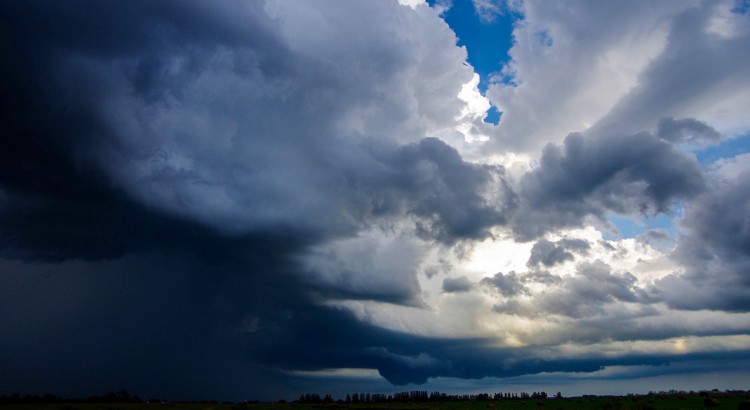
Summer 2016 will be remembered for its intense and frequent thunderstorm activity which caused several tens of millions of dollars in damage across the Prairies. Manitoba experienced its fair share of the action with multiple damaging wind, flooding rain, tornado and damaging hail events – the most some areas have seen in years. Humidity was high, which possibly was one factor that helped fuel a more intense season. Temperatures were pleasant – not too hot and not too chilly. In fact, temperatures averaged bang on normal in Winnipeg.

Average or TotalDeviation from NormalRank Since 1873
High Temperature24.6°C-0.1Equal to median
Mean Temperature18.4°C0.0Tied 65th warmest
Low Temperature12.2°C+0.2Tied 47th warmest
Rainfall231.5mm-16.0 (-6%)63rd rainiest

Overall, it was a wet summer, except for a few isolated locations. Winnipeg’s airport actually saw slightly drier than normal conditions from June to August, but this was mainly a result of a dry August when storms mostly missed the location. June and July were wetter than normal.

Wet Summer For Most

Thunderstorms were a regular occurrence throughout not only southern Manitoba but also Saskatchewan and Alberta this summer. Severe thunderstorms occurred almost daily across the Prairies with only a handful of days seeing no severe weather.

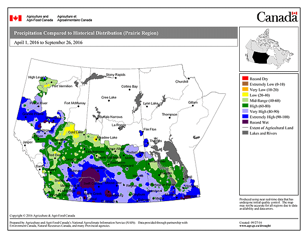
Thanks to the active weather, rainfall amounts were above normal throughout most of the three Prairie provinces. Only localized portions of northeastern Manitoba, central Saskatchewan and southwestern Alberta saw below normal rainfall. The wettest areas relative to normal were the southern Red River Valley in Manitoba, southwestern Saskatchewan and southeastern and northwestern  Alberta. The following two maps from Canada Drought Watch show percent of normal precipitation and precipitation percentiles for the season since April.

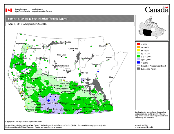
The highest rainfall totals from April 1 to September 8 in southern Manitoba were along the US border in the Killarney to Sprague area where 500 to 750 mm of rain fell. A secondary area of heavier rainfall also occurred east and northeast of Winnipeg with 500 to 650 mm. Letellier took top honours with a whopping 752 mm at the Manitoba Agriculture station. 18 days saw over 20 mm of rain as rounds of heavy rainfall occurred almost every few days. Farmers regularly faced overland flooding on their fields as a result. Other high rainfall totals in the area included Green Ridge with 630 mm, Vita 563 mm, Altona 568 mm, Killarney 520 to 550 mm, Steinbach 530 mm and Morden 490 to 550 mm. High rainfall totals also fell in the Whiteshell area where heavy rains at times caused serious flooding. About 620 mm of rain fell in Falcon Lake and 572 mm in Hadashville during the period. All the above rainfall totals are via Manitoba Agriculture, Manitoba Fire and Cocorahs.

In Winnipeg, rainfall was slightly above average at the airport between April 1 and September 8 with 365 mm. Average for the period is close to 340 mm. Higher totals fell in other parts of the city however, with 420 to 470 mm in western and southern sections.

Year of Severe Thunderstorms and Tornadoes

A total of 16 tornadoes occurred in Manitoba this year; 1 in May, 2 in June, 5 in July and 8 in August. This is up from 11 tornadoes last year and the most tornadoes in a year in a couple of decades (the 1980’s to early 90’s was a busy period). Manitoba also had the most tornadoes in Canada this year. There were a number of multi-tornado-day events including 4 on August 8 and 3 on July 20 and August 3.

There were many notable hail and wind events this summer across southern Manitoba, too many to list. As a result, I have prepared a list below of what I believe were the top 5 events of the summer.

Top Thunderstorm Events

I have listed, in chronological order, what I believe were the top thunderstorm events of the summer in southern Manitoba
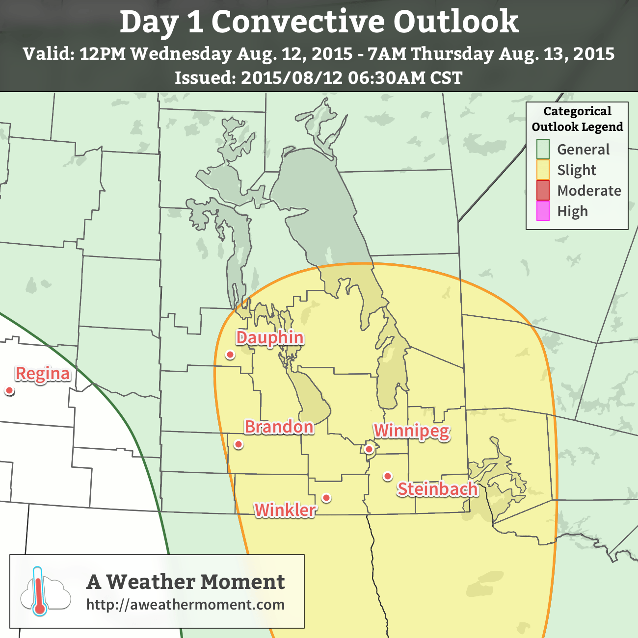
June 24/25 Derecho

A rare derecho event occurred from the evening of June 24th into the overnight on June 25th. A severe thunderstorm complex moved in from Montana and raced across southern Manitoba. A derecho is one of the  most intense thunderstorm events with respect to wind. By definition, it is a thunderstorm complex that produces winds of at least 50 knots (93km/h) along a swath at least 400 km long and whose life span exceeds 6 hours. In addition, no longer than 2-3 hours must pass between successive wind reports. These criteria were met during the June 24/25 event. The following map shows AWM`s Convective Outlook Verification for the event and is included here to show where the severe events were recorded.

Verification of the AWM Convective Outlook for Junes 24/25, 2016
Verification of the AWM Convective Outlook for Junes 24/25, 2016 with hail and wind reports overlaid. Additionally, flooding due to rainfall was reported in several locations within the slight risk region.

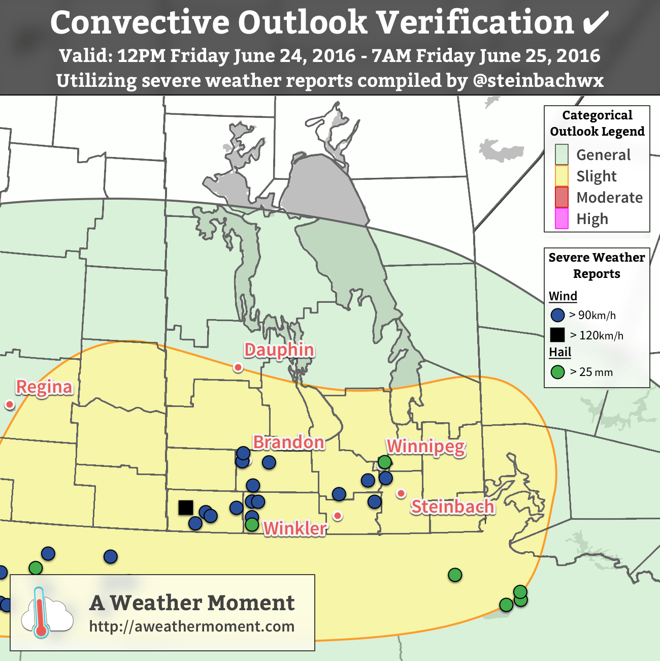
Winds in excess of 90 km/h occurred in a swath from Melita to Carberry to Carman to Saint Adolphe with the derecho. Melita was pummelled with a maximum recorded gust of 124 km/h! Trees, fences and homes suffered damage. Gusts over 100 km/h occurred in Deloraine (102 km/h), Waskada (107 km/h) and Carberry (102 km/h), and gusts over 90 km/h occurred in Killarney (96 km/h), Somerset (90 km/h), Ninette (90 km/h), Carman (93 km/h), Morris (91 km/h), Sanford (90 km/h) and Saint Adolphe (92 km/h). Damage was widespread and significant with snapped trees, crop damage and other property damage. Streets in some areas were littered with branches and debris the next morning.

A narrow jet (sting jet?) of winds between 90 and 110 km/h also occurred in the Brandon area behind the massive thunderstorm complex around 4 am. This was a very interesting occurrence because these winds occurred behind the storms and would be a great case study project. Brandon airport recorded a gust of 106 km/h with the event. Forrest, just north of Brandon, recorded a gust of 98 km/h. Trees were snapped and uprooted, which caught many by surprise because there was no thunder or lightning and only light sprinkles occurring at the time.

Wind was not the only severe weather with the storms. Toonie sized hail occurred south of Killarney and nickel sized hail in Winnipeg. Flooding was a problem as well. 80 to 100 mm of rain fell in the Killarney area with a swath of 50 to 80 mm northeastward to Elm Creek. Winnipeg received 25 to 40 mm with highest amounts in southern and eastern sections. Estimated wind gusts near 80 km/h also occurred in the south end as the city was brushed by the strongest winds to the south. Another swath of 50 + mm fell from Selkirk southeastward to Falcon Lake. In fact, the Falcon Lake/West Hawk Lake area received an incredible 140 to 160 mm of rain. Flooding was severe with some highways underwater and closed. Lake levels in the area were unusually high.

July 20 Supercells / Long Plain Tornado

A series of severe thunderstorms developed in southwestern Manitoba and southeastern Saskatchewan after 4 pm and raced eastward through southern Manitoba in the evening.

The storms dropped up to tennis ball sized hail in extreme southeastern Saskatchewan before entering into Manitoba. In Manitoba, numerous funnel clouds were seen with the storms west and southwest of Brandon. Two of these became landspout tornadoes near Hartney. With no damage reported, these were rated EF-0. The main story initially was the hail with toonie to tennis ball sized hail from the Melita to Brandon areas. The City of Brandon was hit hard with hail up to golf ball sized, wind gusts over 80 km/h and up to 40 mm of rain in 1 hour.

The supercells then continued eastward with incredible wind gusts and a damaging tornado south of Portage la Prairie. A summary of wind gusts is provided in the following table:

LocationMaximum Wind Gust (km/h)
Portage Southport138
Selkirk115
Mountainside110
Winnipeg Int'l Airport107
Elm Creek107
Starbuck101
Gretna96
Cartwright95
Carberry94
Deerwood93

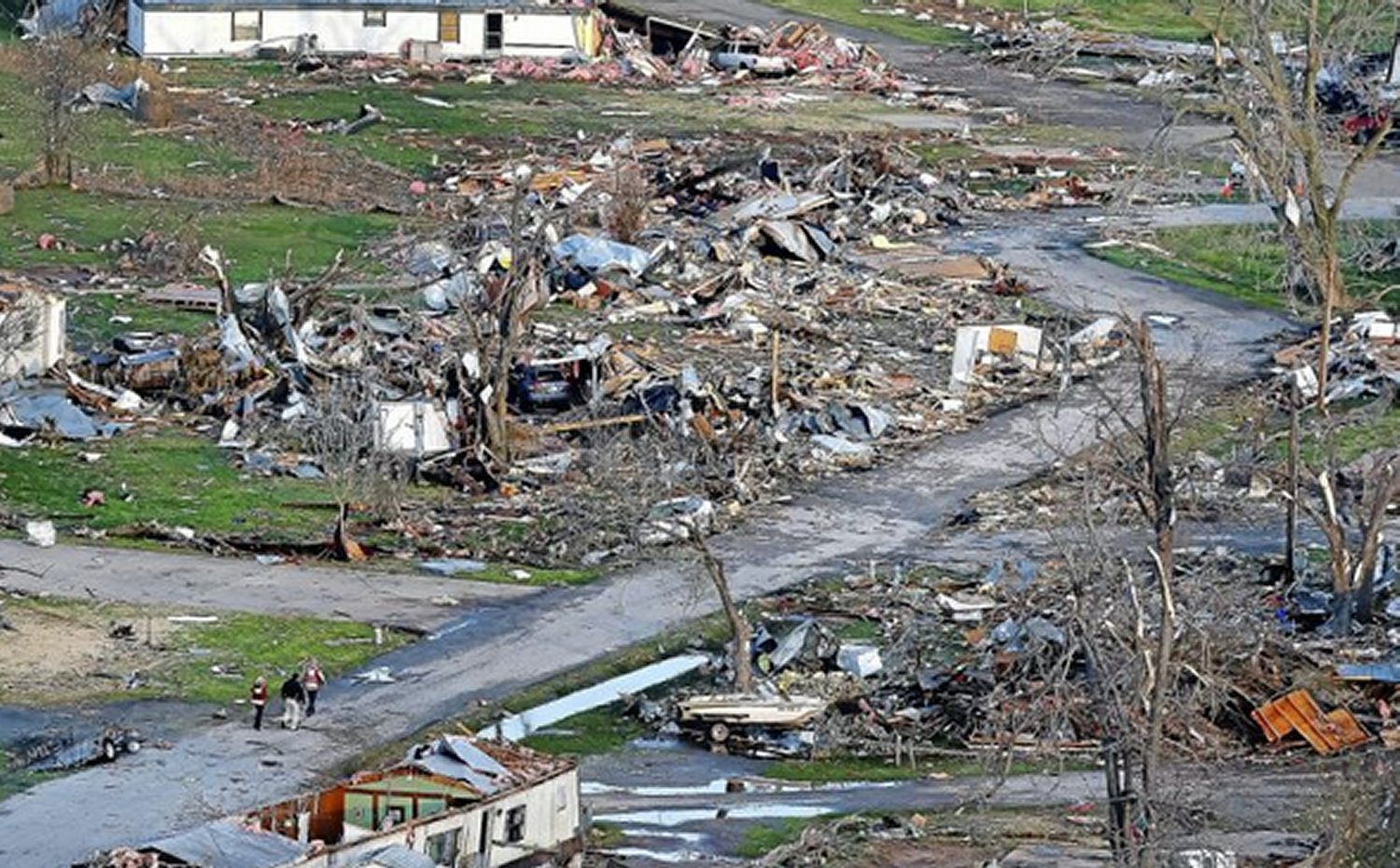
The area south of Portage was worst hit with winds over 130 km/h recorded. Widespread and significant damage occurred with trees toppled and uprooted and buildings damaged. A supercell tornado also occurred at the Long Plain FN and New Rosedale Hutterite Colony south of Portage. Buildings were shifted off their foundations, roofs ripped off homes, hydro poles toppled, cars flipped, sheds and farm buildings destroyed and trees were again toppled and uprooted by the tornado. Debris was scattered across fields downwind. The tornado was rated an EF-1. According to CBC, about 150 homes were damaged and some residents remain displaced in September. A video of the tornado from a distance exists here. A timelapse of the storm coming in Winnipeg exists here.

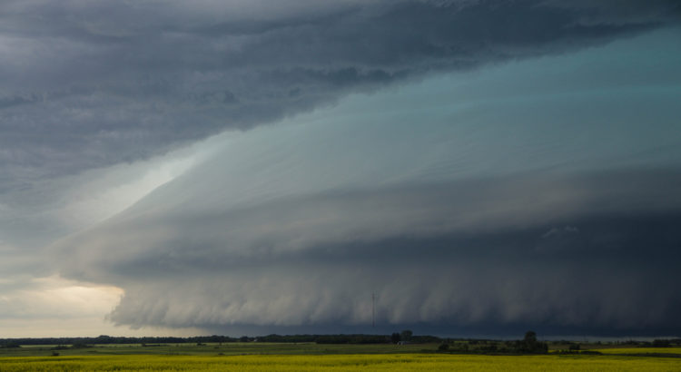
The storm then raced east toward the Winnipeg area. The storm was one of the most ominous storms ever seen with a massive shelf cloud, nearly-constant flashes of lightning and a sky that was almost completely green. Damaging winds occurred with a gust of 107 km/h at Winnipeg International Airport and 115 km/h in Selkirk. Significant damage occurred with trees toppled and some buildings damaged. A roof was partially ripped off an apartment building in north Winnipeg. An estimated 1 million dollars in damage also occurred to a U of M professor`s equipment at the St. Andrews airport. Wind damage also occurred in the Beausejour, Anola, Treherne, Elie and Elm Creek areas. According to Manitoba Hydro [CBC], at peak, 32,000 Manitobans were without power, about 20,000 of which were in Winnipeg.

August 3 Tornado Outbreak

A series of supercell thunderstorms developed in southwestern Manitoba and North Dakota in the afternoon and persisted through the evening. The storms produced numerous tornadoes with three tornadoes in Manitoba: at least one tornado near Glenboro, one tornado west of Morden  and a landspout tornado near Margaret.

The town of Glenboro was lucky as a tornado narrowly missed the town. A tornado formed south of the town after 5 pm and the storm continued to produce a tornado for close to half an hour as it continued northeastward and crossed highway 2. The tornado at one point was a massive wedge tornado northeast of town. Farm sheds and buildings were damaged or destroyed, trees were uprooted and hydro poles were toppled by the tornado. Video of tornado exists here. The storm also dumped 57 mm of rain in 1 hour in Glenboro and 54 mm in 1 hour in Holland to the east. Peak rainfall was just north of Glenboro with a 79 mm storm total recorded at a Weather Farm station.

The Morden area was hit hard by storms moving up from North Dakota. A wind gust of 111 km/h was recorded at the airport. Streets in the city were littered with twigs, branches and toppled trees and shingles were ripped from roofs. Streets were also flooded after 30 to 50 mm of rain fell. A tornado was also seen west of the city in pictures, but no damage directly related to the tornado was ever reported.

Wind damage also occurred in Portage la Prairie, Plum Coulee and Gretna thanks to wind gusts between 80 and 95 km/h.

Storms danced around Winnipeg during this event with only a few mm of rain recorded. Lightning was spectacular however. The storms had just scraped the south end. Saint Adolphe, a short drive south of Winnipeg, recorded 54 mm of rain in 1 hour and a wind gust of 92 km/h. Branches were taken down and some minor flooding was reported.

The low pressure system responsible for the thunderstorms on August 3 also produce slow-moving thunderstorms in the wrap-around portion of the system north of Dauphin. 150 to 190 mm of rain fell in the Ethelbert area in just 6 hours. Flooded fields were reported.

August 8 Tornado Outbreak

Supercell thunderstorms developed in Saskatchewan and moved into southern Manitoba southwest of Riding Mountain National Park, producing the largest tornado outbreak of the year in terms of number of tornadoes. Four tornadoes were confirmed, two of which were rated EF-2 and two rated EF-0. The storms, which tracked from Russell to Erickson, also dumped hail up to tennis ball sized.

Waywayseecappo FN was hit by one of the EF-2 tornadoes. Several homes were damaged or completely destroyed. A school bus was also flipped on its side. Hail up to golf ball sized also fell with the storm. Some residents were evacuated after the storm.

A summary card produced by AWM for the August 8, 2016 tornado outbreak.

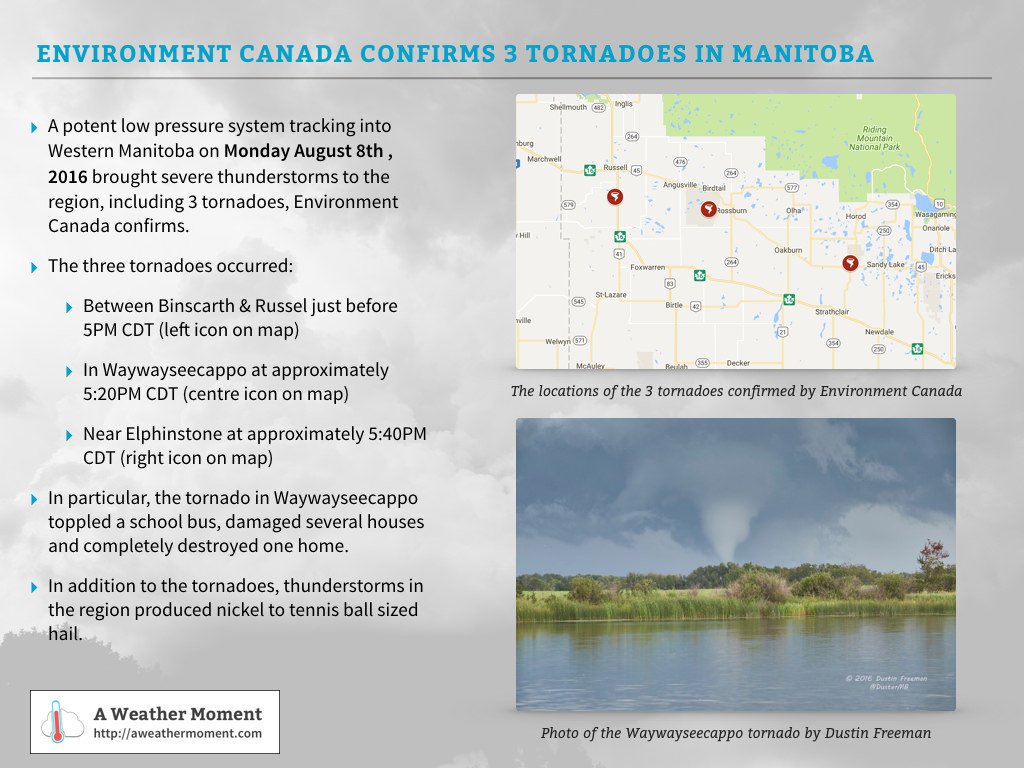
The other tornadoes were south of Russell, near Elphinstone and near Erickson. The one south of Russell was rated an EF-0 based on tree damage. The one near Elphinstone was also given an EF-0 rating due to no reports of damage. The tornado near Erickson was rated an EF-2. A long swath of forest about 500 metres wide was completely flattened (seen thanks to aerial photos from CBC) and bark ripped off trees. Swirls could be seen in the forest from above, confirming that a tornado indeed produced the damage. The tornado also damaged homes and other buildings in the area. The storms continued southeastward after the last tornado, but weakened.

High Humidity

With an average dewpoint temperature of 13.7°C, summer 2016 tied with 2005 for third most humid summer since 1953 in Winnipeg. Some might think this stat is a little surprising because the summer really wasn’t that hot. In fact, temperatures were only near normal overall and very hot days were few and far between. This was probably a good thing because otherwise, the high humidity combined with hotter temperatures would have made the summer much more unbearable.

July 20 saw the peak humidity of the summer when dewpoint temperatures rose to the 24 to 27°C range across southern Manitoba, breaking records. At Winnipeg Int’l Airport, dewpoint peaked at 25.9°C, the second highest dewpoint reading on record since 1953. The record is 26.1°C on July 17, 1966. Dewpoint temperatures reached an amazing 27°C in Carman, Winkler, Portage, Altona, Beausejour and Minnedosa. The highest reading was in Carman at 27.4°C. The heat and humidity together produced humidex values in the mid 40`s.

Hottest Day of the Year Was Outside of the Summer Season

Consistent with few very hot days this summer, the hottest day of the year was actually outside of the summer season. A high of 35.2°C on May 5th was the hottest of the year and the earliest date to reach the highest temperature of the year on record since 1872. It was also only the 12th time that our hottest day of the year was in May. The high of 35.2°C was also the earliest occurrence of temperature over 35.0°C on record since 1872. Previous earliest was May 8, 1874 with a high of 35.0°C.

RankDateHigh
1May 5, 201535.2°C
2May 7, 189134.4°C
3 (tie)May 13, 193233.3°C
3 (tie)May 13, 197732.6°C
5 (tie)May 19, 194835.0°C
5 (tie)May 19, 199234.2°C

Warm Year and September so Far

The January to August period averaged 5.5°C in Winnipeg, tied with 1999 for 13th warmest on record since 1873. September so far is averaging just over 2 degrees above normal, making this the 14th warmer than normal September in the last 16 years. September has been and seems to continue to be warming at a rapid pace. In fact, September has warmed 1.0°C in the last 20 years, 0.7°C in the last 10 years and 0.5°C in the last 5 years, showing that warming for the month has accelerated in recent years. The 30-year 1987 to 2016 average for September is 13.4°C, up from 12.9°C in the 1981-2010 normal and the warmest Septembers have been on record. There is certainly no guarantee that this warming trend will continue forever, but what is interesting is how rapidly the month has warmed and how rare it has become to experience a chilly September.

Wall Cloud near Clairevale

Winnipeg & Area’s Top 10 Weather Stories of 2015

2015 brought a huge assortment of wild weather to Southern Manitoba. From torrential rains, damaging wind storms, tornadoes, and above-normal temperatures to snow storms, there wasn’t much waiting between significant weather events. Here’s our top 10 weather stories of 2015!


#10 – Parade of Snowstorms Just Before Christmas

Three snowstorms dumped a total of 40 cm of snow from December 16th to 23rd in Winnipeg.

The biggest snowstorm occurred on the 16th and 17th, dumping 20 cm. Strong winds helped carve drifts up to two-feet deep in some spots. 18 cm fell on December 16th alone at the official Charleswood station, breaking the old record of 8.4 cm in 1942 for the day.

Snowfall totals from the December 22-23, 2015 Snow Storm
Snowfall totals from the December 22-23, 2015 snow storm

With all the snow in mid December, travel was dramatically impacted. Residential streets were difficult to navigate and numerous vehicles were reported stuck in the snow. Thanks to the snowfall, snow depth in Winnipeg sat at 30 cm on Christmas morning; this was the deepest snow pack on Christmas Day in 15 years (since a 30 cm depth in 2000). In total, 44.0 cm of snow fell in Winnipeg in December, 83% above normal and the 12th snowiest December on record since 1872.

#9 – Dry Winter and Warm January

After a frigid start to January, a warm spell blessed southern Manitoba with above normal temperatures. A 17-day streak of above normal temperatures occurred from January 14 to 30. During this period, daily highs averaged -1.9°C and daily lows averaged -12.1°C, about 10°C warmer than normal. 6 days in the period exceeded the freezing mark and 6 days never saw temperatures dip below -10°C. The warmest days were January 22 and 23 when temperatures soared to 3.7°C and 3.1°C at the airport respectively. It was warmer inside the city with highs between 4 and 6°C. Some parts of southern Manitoba never even dipped below freezing on January 23. The extended warm spell melted what little snow was on the ground. By January 31, snow depth in Winnipeg was 12 cm, the 12th thinnest on record for the day since 1941. Gloomy skies and freezing drizzle were also common during the warm spell.

In the end, January averaged -13.7°C, tied with 2010 for 19th warmest since 1873.

Overall, it was a very dry winter. Only about 31 mm of precipitation fell from December to February, the 9th driest winter on record since 1872. 44.4 cm of snow fell, the 29th least snowy winter.

#8 – A Summer of High Humidity

With an average dewpoint of 13.6°C (June to August), summer 2015 tied with 1996 for 4th most humid summer on record in Winnipeg since 1953. 22 days from June to August saw dewpoints exceed 20°C, the 2nd most since 1953 and well above the normal of 10 days.

Dewpoint temperatures in July specifically averaged 16.1°C, the 2nd most humid July and month on record since 1953. The 1981-2010 normal is 14.2°C. An 8-day streak with dewpoints over 20°C occurred mid month. A maximum dewpoint of 24.1°C was achieved on July 12, breaking the old record of 23.9°C in 1955 for the day. 14 days saw dewpoints over 20°C, tied with 1957 for most on record in July since 1953.

A 5-day heat wave hit southern Manitoba in mid August. Temperatures exceeded 30°C and on some days 32°C. August 14 was the hottest day with some records broken, including in Brandon with a high of 36.6°C. Four days with dewpoints over 20°C accompanied the heat wave. Dewpoint temperature peaked at 24.5°C in Winnipeg on August 15, shattering the old record of 21.7°C in 1972 for the day. It was also the latest occurrence of dewpoint over 24°C since 1953. High minimum temperature records were also broken in Winnipeg (21.2°C) and Morden (22.0°C).

#7 – Summer in September

September began with a three-day heat wave as temperatures exceeded 30°C and in some cases 32°C. Oppressive humidity accompanied the heat which is unusual for September. The main records broken during the heat wave are listed below. Note: temperature records go back to 1872 while dewpoint and humidex records go back to 1953.

  • Record high minimum of 21.0°C on the 3rd was also the second highest in September.
  • Two high dewpoint and three high minimum dewpoint records were broken, including:
    • High dewpoint of 23.1°C on the 3rd was also just shy of the all-time September high of 23.4°C in 1983 and was the second highest in September.
    • A high minimum dewpoint of 18.7°C on the 3rd was also an all-time high for September.
  • Humidex reached 42.0 on the 3rd, the second highest in September. This, along with a humidex value of 40.1 the previous day, were only two of six occurrences of humidex over 40 in September since 1953.

Strong thunderstorms on the 4th and 5th ended the heat wave with a bang. Severe storms between 1 and 8 am on the 4th dropped dime to toonie size hail southeast of Winnipeg and northwest of Minnedosa. Strong thunderstorms moved up the Red River Valley in the afternoon. The Winnipeg area saw 30 to 50 mm of rain in under an hour, causing severe street flooding. Wind gusts over 80 km/h also caused some damage. With more rain later on, daily totals sat between 40 and 60 mm. The airport recorded 41.1 mm, breaking the record of 36.8 mm in 1872. Heavy thunderstorms moved up the Red River Valley again on the 5th, dumping 15-40 mm of rain southeast of Winnipeg.

Another 30°C day occurred on September 13. Winnipeg reached 31.6°C, just shy of the record of 31.7°C in 1927. Records were broken along the US border including in Morden and Pilot Mound where highs of 33.8°C and 33.3°C occurred.

It was the 6th warmest September on record since 1872 in Winnipeg with an average mean temperature of 15.8°C. It was also the second warmest since 1949. Dewpoint temperatures averaged 9.8°C, the 3rd most humid September since 1953.

#6 – A Very Early Spring

April-like temperatures arrived by the second week of March. Record highs were achieved on the 14th and 15th. Winnipeg reached 13.2°C on March 14, breaking the old record of 11.4°C in 1981. A high of 14.3°C the following day was just shy of the record of 14.4°C in 2012. The warmest temperatures occurred along the US border. Morden reached 18.3°C on the 14th and 17.6°C on the 15th, the earliest occurrences of temperature over 16°C on record since 1904. The high of 18.3°C on March 14 broke the old 2012 record by an impressive 7.1°C! Nights were unusually mild as well. A morning low of 6.7⁰C in Winnipeg on March 15 was the warmest morning low for so early in the year since 1953.

The winter snow pack disappeared in Winnipeg by March 15, tied with 1995 for third earliest snow melt since 1955. This was a day later than in 2012 and a day earlier than in 2010.

In the end, March averaged -3.0°C, 2.8°C warmer than normal and the 20th warmest March since 1872. Even thunderstorms with small hail occurred on March 30 west and north of Winnipeg. No thunder was heard in Winnipeg but small hail fell in the south end with some convective showers.

#5 – Active Thunderstorm Season in Southern Manitoba

Manitoba had the greatest number of reported tornadoes and waterspouts in Canada for 2015. In addition, Manitoba had the most severe hail and severe thunderstorm rain reports of the three Prairie provinces.

At least 11 tornadoes and waterspouts occurred in Manitoba in 2015, the most in more than 5 years. Two events brought worldwide attention: at least 2 tornadoes and waterspouts on July 18 near Matlock and at least 3 tornadoes on July 27 in southwestern Manitoba(3 tornadoes were mentioned in Justin Hobson’s chase story).

On July 18, a landspout tornado near Matlock travelled over Lake Winnipeg, becoming a waterspout. The storm produced at least one other waterspout and they occurred simultaneously. The storm and funnels were photogenic and photos spread around the world on social media.

On July 27, a supercell travelled over 100 km from Tilston to northeast of Virden, producing multiple tornadoes in a 3-hour timeframe. Some were violent as seen on videos. One tornado reached about a kilometre wide. Luckily, the tornadoes dodged all major communities.

Only a few farms and highways experienced damage. Environment Canada sent a damage survey team to investigate. The worst damage they saw was from a high-end EF-2 tornado (winds close to 200 km/h). It is entirely possible that the tornadoes may have been even stronger, but because they weren’t hitting anything significant it is impossible to tell.

Hail was also a big story this summer across southern Manitoba. The greatest proportion of severe hail reports were in August thanks to extreme nocturnal activity mid and late month. Significant hail events occurred on August 12, 22 and 28.

Along with parts of southern Alberta, southern Manitoba had the greatest concentration of severe thunderstorm warning days as seen in the map below. The Minnedosa warning region of southwestern Manitoba saw 19 days in 2015 with a severe thunderstorm warning, the most of all warning regions in Canada.

#4 – May Long Weekend Storm

A Colorado Low slammed southern Manitoba during the May Long Weekend. Heavy rain, damaging wind, large waves on the lakes and snowfall occurred.

The rain in Winnipeg began late on Saturday May 16 and persisted the entire day on Sunday May 17. 35-50 mm fell in the city. 31.3 mm fell at Winnipeg airport on May 17 alone, breaking the old record of 22.9 mm in 1903 for the day. Heavier rains fell to the southwest with 50-90 mm from Morden to Carman to Melita. Significant overland flooding occurred with many farm fields underwater.

The rain was accompanied by sustained winds of 47 to 63 km/h at Winnipeg airport for 22 consecutive hours. Wind gusts were between 80 and 95 km/h. A peak gust of 93 km/h was recorded in Winnipeg. The wind damaged property, caused power outages and uprooted trees. In addition, larges waves and storm surge occurred on Lake Manitoba and Lake Winnipeg.

On Monday May 18, snow and strong wind occurred. Snow fell throughout the night, ending in the morning. The cold and wind combined to produce wind chill values of -9. Between a dusting and 3 cm of snow fell in Winnipeg, depending where you were. 2.5 cm was measured in Charleswood on May 18 alone, just shy of the old record of 3.0 cm in 1963. A snow depth of 2 cm in the morning observation broke the old record of trace cm. The snow melted in the afternoon. This was the latest spring snowfall in Winnipeg since 2002 when a trace cm fell on May 23 and the latest snowfall accumulation since 1969 when 0.3 cm fell on June 12. Prior to this year, snow had fallen on May 18 only 4 times since 1872. Heavier snow fell west of the city with a swath of 10-15 cm from Boissevain to McGregor to Teulon to the Gimli area.

#3 – August 22-23 Severe Thunderstorms and Heavy Rain

Significant thunderstorms and heavy rain pummelled Winnipeg and the surrounding area on August 22 and 23. Due to extreme nature of the event and the large area affected, the event is considered number three in the Top 10 series.

The event began overnight on August 22 when severe thunderstorms developed north of a warm front. The bulk of the storms remained north of Winnipeg, sparing the city from the worst of the event.

The city got a spectacular lightning show, while the cottage-country north of Winnipeg and a few towns northwest of the city took the brunt of the storms. Very large hail fell from Westbourne to Teulon to Matlock to Beaconia to Silver Falls. The largest hail stone reported was 10 cm in diameter, located near Silver Falls. Significant and widespread damage occurred as a result. Locally 40-50 or more mm of rain also fell within an hour, causing overland flooding. The following table gives a chronology of storm reports from the event.

Table: Chronology of storm reports from the overnight thunderstorms of August 22
Approx. Time Location Event
2:00 am Westbourne Nickel to golf ball size hail.
4:15 am Teulon Quarter size hail with significant accumulation. Tree, garden and vehicle damage occurred. 43 mm of rain in 1 hour caused overland flooding. Mounds of hail still remained on the ground hours after the storm.
4:45 am Matlock 5 cm diameter hail.
5:15 am Grand Marais Gold ball size hail.
5:30 am Beaconia Baseball size hail punched holes in roofs and totalled almost every vehicle left outside during the storm. 50+ mm of rain also fell within an hour.
5:45 am – 6:00 am Pine Falls, Powerview and Silver Falls area Nickel to softball size hail. One photo showed a 10 cm diameter hailstone.

Heavy thunderstorms developed again midday in the Red River Valley. Winnipeg was particularly hard hit by these. 50 mm fell in less than 1 hour in parts of the south end. Nickel to toonie size hail, wind gusts to 80 km/h and frequent lightning also occurred, making for quite a storm to remember. Numerous streets and underpasses flooded and some were impassable. Water seeped into and flooded parts of St Vital Mall. Lightning caused a few fires and wind snapped branches.

Rainfall totals from the August 22-23 Storms
Rainfall totals from the August 22-23 storms

The afternoon thunderstorms also dumped some large hail in other areas. Nickel to quarter size hail fell in Oakbank, Winkler and Jessica Lake. Training thunderstorms continued to pummel southeastern Manitoba late afternoon and evening, dumping significant rainfall. Rain from these also spread into the Winnipeg area and Red River Valley. Wrap-around rain around the low pressure system continued to drench south and southeastern Manitoba in the overnight and morning on August 23. Two-day rainfall totals were significant. Widespread totals of 50 to 110 mm occurred throughout the Red River Valley, southeastern Manitoba and the Interlake. In Winnipeg, close to 75 mm fell in southern sections of the city. At Winnipeg airport, about 46 mm fell. 38.4 mm of this fell on August 22 alone, breaking the old record of 38.1 mm in 1959 for the day.

#2 – Warm and Moist Fall

All three fall months (Sep, Oct & Nov) finished in the top 30 warmest on record since 1872 in Winnipeg: September was 6th warmest, October tied 30th warmest and November tied 16th warmest. It was the 4th warmest fall on record since 1872 with an average mean temperature of 7.3°C, tied with 1953 and 2009. Brandon also had a 4th warmest fall on record (since 1890), averaging 6.2°C.

In October, the warmth peaked during the Thanksgiving weekend. Record warmth was seen along the US border with highs near 28°C in Pilot Mound, Morden and Sprague. Winnipeg reached a non-record maximum of 24.6°C on the 11th. Even some weak thunderstorm activity occurred in the evening on the 11th, ahead of a strong low pressure system which produced damaging winds the following day.

A 25-consecutive day streak of above normal temperatures occurred from October 26 to November 19. During this time, 10-consecutive days from October 27 to November 5 never dropped below freezing. Warmth and humidity returned mid November before winter-like conditions arrived. Temperatures exceeded 10°C from the 14th to 16th with a maximum of 13.1°C on the 15th. Unusually high humidity also occurred with dewpoints reaching 9.4°C on the 16th and 9.3°C on the 17th, both record highs and the latest occurrences of dewpoint over 9°C on record since 1953. Thanks to the high humidity, a record high minimum temperature of 5.3°C was achieved on the 16th, the latest minimum above 5.0°C since 1872.

Dewpoint temperatures averaged 3.2°C in fall 2015, t he second most humid fall on record since 1953. November dewpoint temperatures in particular averaged -2.9°C, the highest on record, beating the old record of -3.0°C in 1981.

Thanks to warm conditions, the first accumulative snowfall was on November 18 in Charleswood, Winnipeg’s official station for snowfall. This was the 4th latest first snowfall accumulation of the season since 1872. It was also a month later than the normal of October 18. In addition, no snowfall was recorded in October, only the 16th time this has occurred since 1872.

#1 – Amazingly Warm Start to December

Remarkable warmth started December across southern Manitoba. 8 to 10 days in the first half of the month exceeded the freezing mark in Winnipeg, above the normal of 4 days for the month. 14-consecutive days from the 3rd to 16th never dropped below -9°C at Winnipeg airport, amazing when you consider this was close to the normal high. Temperatures reached 7°C downtown and 4°C at the airport on the 3rd, one of the warmest days of the month. The only record broken during the warm spell was on December 9 when a high of 5.6°C at the airport broke the old record of 5.1°C in 1990.

Morden, MB – Cutting grass in December.
December started with such warmth that the grass still needed to be cut in Morden, MB.

The warmth was most impressive where there was no snow cover. 3 to 7 cm of snow was leftover from November in the Winnipeg area and this limited temperature. Areas without snow cover southwest of the city and in southwestern Manitoba were much warmer. Many locations reached double digits and in some cases more than once. In Morden, four days exceeded 10°C, three of which were record highs. The high of 14.2°C on December 4 was the third warmest on record in December since 1904. Some thermometers reportedly reached 15°C, more typical of late September or early October. No snow was on the ground at the time. A similar milestone was reached in Brandon with a high of 11.1°C on the 4th, the third warmest temperature in December since 1890.

The first half of December (December 1 to 15) averaged -3.0°C at Winnipeg airport, the second warmest first half of December on record since 1872. The warmest was in 1913 with an average of -2.1°C. The month as a whole averaged -8.1°C, tied with 2011 for 9th warmest December since 1872.

Scorching Summer Weather Sizzles Southern Manitoba

Temperatures will soar into the low 30’s over the coming days as a broad upper-level ridge continues to build across the Canadian Prairies, bringing with it some of the warmest temperatures of the year. Alongside the heat will come several bouts of humidity; at times over the coming days, humidex values – a “feels like” temperature that combines the effects of heat and humidity – will approach or exceed 40, making for exceptionally sweltering weather. In addition to the heat and humidity, today will bring a risk of severe thunderstorms…if they’re able to develop this afternoon.

Wednesday: Hot, Humid & Significant Thunderstorm Risk

Today will be a scorching hot day that will be made oppressively hot by the increasing humidity through the day. Temperatures will soar quite quickly today with the mercury reaching around 30°C by lunch time and then climbing a few more degrees above that this afternoon. All the while, the dew point will climb to the 19–20°C mark, resulting in humidex values in the 37–41 range for much of the day.

The biggest weather story for today, though, is the thunderstorm potential. First, here’s our outlook for today, but the discussion is important, so don’t skip over the rest!

AWM Day 1 Convective Outlook for August 12, 2015

A slight risk of severe thunderstorms exist across the Red River Valley, the Interlake region and eastwards to the Ontario border. Any storms that manage to develop today will have the potential to become very potent storms capable of all types of severe weather, including tornadoes, however there remains a single big question: will there be any storms?

As always, lets take a look at the basic MIST principles of thunderstorm forecasting:

  • Moisture: Ample moisture will be in place as surface dew point values climb to 20°C. 30mb mixed layer dew points are also expected to be in the high teens, which will make for ample fuel availability in convection.
  • Instability: Instability is strong but conditional. Given the high moisture values, MLCAPEs will sit in the 2000–2500 J/kg range while SBCAPE values may exceed 3000 J/kg. The crux is, however, the capping inversion. Strong insolation will chip away at the cap through the day, however 30–50 J/kg of inhibition will likely remain.[1] The big question is, will the combination of surface trough and lake breeze interactions provide enough lift to break the cap? If any storms do manage to initiate, it’s all clear for explosive growth in a strongly unstable environment.
  • Shear: Shear looks fantastic for the development of strong, sustained supercell thunderstorms. 0–6km bulk shear values are expected to be in the 30–35 kt range while hodographs show excellent curvature. No questions exist about how favourable the shear is for supercell thunderstorm development.
  • Trigger: As mentioned above, two triggers will be in place today. The first is a trough line pushing through the Red River Valley & Interlake this afternoon. The second will be various surface boundaries developed through differential heating on escarpments (RRV, Gunton Bedrock) or lake breezes. It’s only slightly likely than any one of these features would be able to provide enough lift to trigger a thunderstorm, however if two or more of these features interact, it could trigger thunderstorm development. The trigger is the biggest uncertainty with today’s thunderstorm potential.

All these factors together combine to give a slight risk of severe thunderstorms across a wide region of Southern Manitoba. Despite the “lower” threat classification, all types of severe weather – flooding rains, large and damaging hail, severe wind gusts, tornadoes – are possible in thunderstorms in the Red River Valley today. The slight risk is given not for thunderstorm intensity – any thunderstorms that develop today could be very, very strong – but rather for the uncertainty associated with if they’ll even occur and expected isolated nature of the storms.[2]

On tornado potential: Today brings with it a non-zero tornado threat, particularly for areas in the northern half of the Red River Valley and southern sections of the Interlake region. Hodograph curvatures are very impressive, and when storm-relative values are taken into account, helicities will be quite high in any thunderstorms that manage to develop. Cloud bases will be fairly high, but high dew points should help diminish significant evaporative cooling below the cloud base. Numerous parameters show favourable environments for thunderstorms capable of producing tornadoes as well. It’s impossible to forecast a tornado this far in advance, but if you live in the slight risk area, it would probably be wise to keep up to date on any watches/warnings issued by Environment Canada.

Temperatures will dip to around 19°C tonight with slightly less humid conditions.

Thursday: A Brief “Cool Down”

Marginally cooler air works into Southern Manitoba behind Wednesday’s trough line which will be reflected in daytime highs a whopping 1–3°C cooler, but still likely at 29–30°C or a touch warmer. Perhaps the bigger difference will be more tolerable humidity levels as dew point values drop into the low teens by the end of the day. Skies will be mainly sunny with relatively light northwesterlies as a ridge of high pressure builds in.

Winds shift southerly in the evening as the Red River Valley moves onto the back-side of the surface ridge and warmer air begins to push in again. Expect a low near 16°C.

Friday: Don’t Worry, It’s A Dry Heat

The heat is back on Friday with daytime highs climbing back to around 33–34°C. It won’t feel as hot as Wednesday, however, thanks to significantly lower dewpoints in the low- to mid-teens. While we’re not talking Arizona desert heat, it’ll be far more comfortable than the 20°C dew points earlier in the week.

Heading into Friday night, deep-layer moisture transport ramps up and will begin bringing significant amounts of moisture into the region aloft. This, combined with warmer air moving in, will lead to a fairly balmy night with lows near the 20°C mark.

Long Range: Severe Storm Threat Returns on Saturday

It looks like a threat of severe thunderstorms returns to Winnipeg & the Red River Valley on Saturday. Very humid conditions with highs in the upper 20’s will clash with a cold front moving in from the west. Showers and thunderstorms are probable with this front, and with significant energy and shear in the region, it’s entirely possible for severe thunderstorms to develop. It will all depend on the exact strength & timing of the cold front, so we’ll take a closer look at that on Friday when the event is closer.

Sunday will be a comparatively cold day with partly cloudy skies, a bit of a breeze and highs in the low 20’s.


  1. Many studies show that some of the strongest supercell thunderstorms form in environments with between 25–50 J/kg of inhibition.  ↩
  2. At this point, we’re not expecting a huge line of thunderstorms to roll across the Red River Valley; rather it seems probable that there would be just one or two very strong storms.  ↩

Elsewhere in Weather News: March 28th, 2015

First Significant Severe Weather Event of the Season Strikes Oklahoma

This past Wednesday severe storms erupted across much of Oklahoma bringing with them very large hail and even tornadoes. It was the biggest severe weather day this year in the states, up to now (but many more are to come). A surface low was located in central Oklahoma with dryline extending southward, cold front crashing south from the north side of the low, and a warm front extending northeastwards from the low. There were two main focus areas for the storms – along the dryline and near the triple point/along the warm front. A moderate risk was issued by the SPC and covered the areas of concern. The outlook also included a 5% tornado risk with 45% hatched hail probabilities. A moderate jet streak was in place with dewpoints in the high teens, which together provided sufficient shear and CAPE for supercells.

[map type=”terrain” autofit=”1″ disable_scrollwheel=”1″] [pin]Sand Springs[/pin] [pin]Moore[/pin] [/map]

As expected, several storms initiated on Wednesday afternoon and grew into supercells. Two supercells were of most concern before storms consolidated into squall lines: one near Tulsa and one near Oklahoma City. The storm that approached Tulsa showed strong rotation on radar early in its lifetime –a tornado warning was able to be issued well before it hit the city. By the time it reached a suburb of Tulsa, Sand Springs, a tornado touched down and tore through a trailer park. In addition to that, hail, the size of tennis balls, were reported in Tulsa’s metro region as the supercell’s hail core passed over the city. The tornado (preliminary rating of EF-2) injured over a dozen people and one person lost their life in the trailer park.

Aerial view of the damage to the trailer park in Sand Springs. (Source: Tulsa World)

The Oklahoma City storm fired off the dryline initially but then got undercut by the cold front – meaning it had little tornado potential. Interestingly enough, the supercell was able to catch up to the cold front and interact with it, enhancing the vorticity in the area – likely being a contributing factor to the formation of the tornado. With this mesoscale interaction playing a significant part in the cause of the tornado, not much lead time was provided to residents (it happened quickly). Unfortunately the twister (preliminary rating of EF-1) touched down in the city of Moore, OK which got hit by a devastating twister in 2013 and had seen two other strong tornadoes since 1999. No injuries were associated with this one, thankfully.

Compilation of radar images before/during/after the Moore tornado showing the storm's interaction with the cold front. (Image compilation by @VORTEXJeff / Twitter)
Compilation of radar images before/during/after the Moore tornado showing the storm’s interaction with the cold front. (Image compilation by @VORTEXJeff / Twitter)

The pattern could become active again by the middle of next week, but it is still too early to be certain. April to late May is typically the busiest time of the year for severe weather in the Southern US Plains, due to plentiful moisture before the jet stream shifts further north for the summer.