A Mixed Bag, But Staying Warm

Winnipeg will see a variety of weather conditions over the next few days, but the early-fall warmth will continue through much of the week.

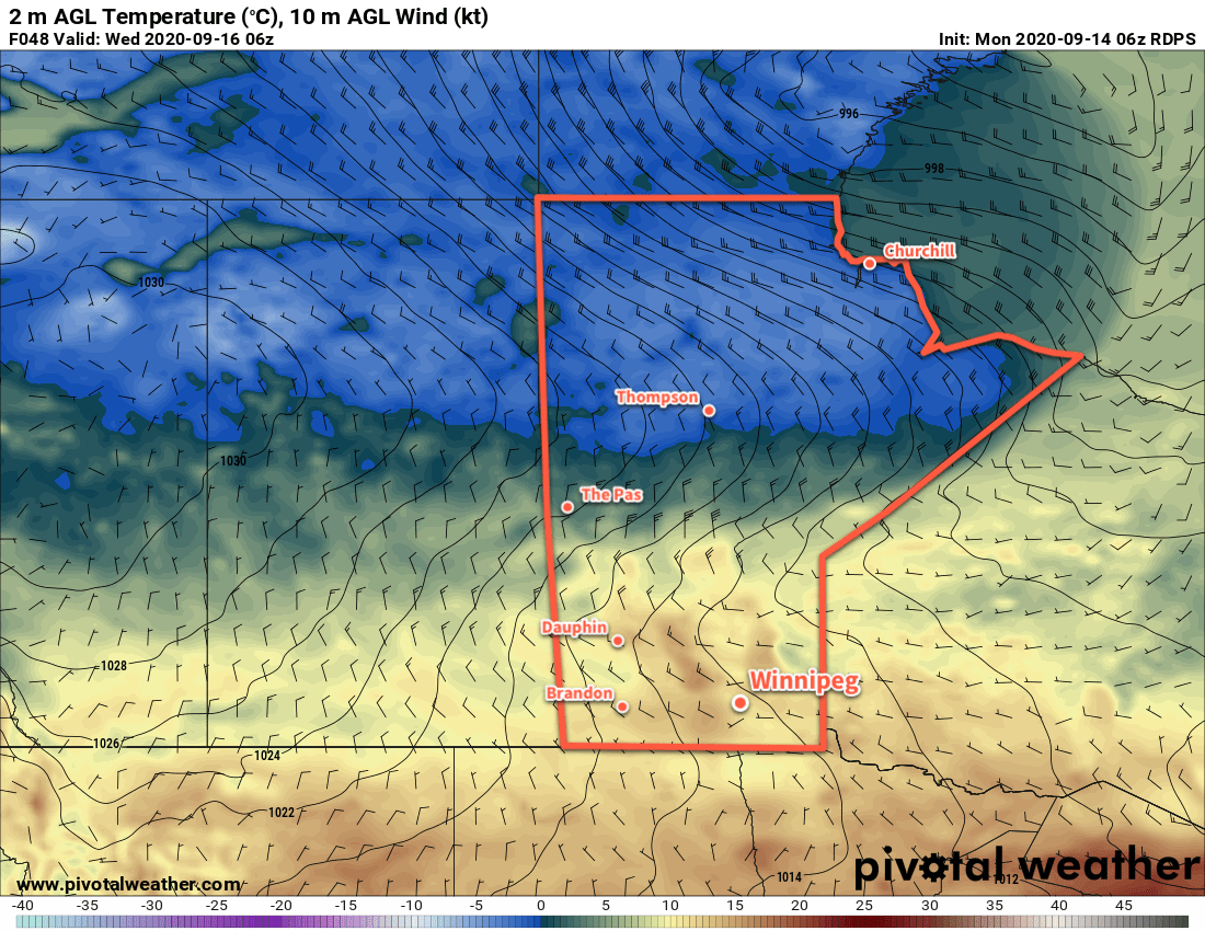
Winnipeg will start the week with windy conditions as a large low pressure system passes by to the north. The city will see mainly cloudy skies today with west-southwest winds of 40 gusting 60 km/h. Temperatures will climb to high near 22°C. The city will see a slight chance of a passing shower, but most of the rain should keep to the north. The cloud cover will being exiting the region late in the day, leaving the city with clear skies tonight. Winds will ease and then shift southerly overnight as temperatures dip to 7°C.

Summer-like warmth returns on Tuesday as southerly winds of 20–30 km/h send highs into the upper 20s. Winnipeg will see mainly sunny skies and a high near 28 °C. Winds will ease in the evening then shift northerly overnight as temperatures head to a low near 13°C. Some cloud associated with an approaching cold front will push into the area overnight.

RDPS 2m Temperature Forecast valid 21Z Tuesday September 22, 2020
Summer-like heat will return to southern Manitoba on Tuesday.

On Wednesday, Winnipeg will once again see mostly cloudy skies and a chance of rain. The interplay between a cold front pushing south and an organized disturbance sliding through North Dakota will be the features that create the weather. Temperatures will be a bit cooler, but still seasonably mild with a high near 19°C. Northerly winds will persist through the day at 20–30 km/h as well. The winds will ease on Wednesday evening as skies clear and temperatures will head to a low near 7°C.

Long Range Outlook

Milder weather returns for the rest of the week with highs again returning into the low 20s. The city will see variable cloudiness with another chance for some rain on Thursday night as another disturbance moves through the region.

Today’s seasonal daytime high in Winnipeg is 17 °C while the seasonal overnight low is 5 °C.

Mild and Breezy Before Mid-Week Cool-Down

After a mild start to the week, cooler weather will return to Winnipeg.

An upper ridge over the Canadian Prairies will help send temperatures back into the 20s to start the week. Winnipeg will see a few clouds today, but skies will also be a bit hazy with forest fire smoke. Temperatures will climb to around 20 °C, accompanied by a brisk southeast wind. As the day progresses, the winds will pick up to 30 gusting 50 km/h for the afternoon.

While the skies will be hazy with smoke, air quality should stay good as the smoke will reside higher in the atmosphere.

Tonight, a low pressure system will track along the international border and spread cloud cover through the region. The wind will ease this evening and temperatures will stay mild with a low of 12 °C.

On Tuesday, Winnipeg will see mixed skies as the low departs to the east. Winds will pick up out of the northwest into the 20–30 km/h range by midday. Fortunately, temperatures will continue to be seasonably mild with a high near 20 °C. A bit of haze may linger from the fires, but the thickest plume will be slumping southwards into the American Plains.

RDPS 2m Temperature Forecast valid 06Z Wednesday September 16, 2020
A cold front will surge southwards through central Manitoba on Tuesday night.

Tuesday night will bring Winnipeg partly cloudy skies, light winds, and a low near 7°C.

A cold front will slump through the Red River Valley on Wednesday morning, bringing a few clouds with a chance of showers. The northwest winds will strengthen back to 30 gusting 50 km/h and keep temperatures cool with a high of just 11 °C. A ridge of high pressure will move into the region on Wednesday night and bring mostly clear skies, light winds, and a low near +1 °C.

Long Range Outlook

The rest of the week will bring partly cloudy skies and seasonably cool temperatures to Winnipeg. On the weekend, temperatures will climb back into the upper teens with increasing cloudiness. Some rain may be possible on Sunday, but will be conditional on how exactly the forecasted low tracks eastwards.

Today’s seasonal daytime high in Winnipeg is 18°C while the seasonal overnight low is 6°C.

More Rain on the Way

A clipper system will begin racing eastwards across the Prairies today, spreading rain into the Red River Valley.

Winnipeg will see a pleasant start to the day; with sunny skies temperatures will climb to a high near 21 °C with westerly winds near 20 km/h. Later today, a clipper low racing across Saskatchewan will spread cloud into the Red River Valley, followed by rain beginning mid- to late-afternoon. The rain will last into the evening, then ease to a few showers and end overnight. Most areas in the Red River Valley, including Winnipeg, will see 5 to 15 mm of rain, but a localized corridor of 15 to 25 mm will be possible. Temperatures will dip down to a low near 10 °C tonight with winds picking up out of the northwest.

Thursday will bring mixed skies with a chance for some lake-effect showers in the morning. Winds will be prominent through the day, sustained out of the northwest up to 40 gusting 60 km/h. It will be a cool day in the wake of Wednesday’s clipper and Winnipeg will see a high of only 17 °C. Skies will clear out in the evening as the winds gradually ease. Temperatures will then head to a low near 6 °C.

NAM 24hr. Precipitation Accumulation Forecast valid 15Z Thursday September 3, 2020
Southern Manitoba will see another soaking as rain moves through on Wednesday afternoon and evening.

On Friday, a weak ridge of high pressure will keep skies mainly sunny with northwest winds of 20–30 km/h. Temperatures will recover slightly from Thursday as Winnipeg heads to a high near 20 °C. A bit of cloud will work into the region overnight as temperatures head to a low near 7 °C and winds ease.

Long Range Outlook

Another low pressure system will cross Manitoba this weekend, but most forecasts show the rain it will bring tracking through WestMan and the Interlake. Winnipeg will likely see mixed skies on Saturday with near-seasonal temperatures, but cloudier, cooler conditions return on Sunday. The weekend may end with a chance of showers as a cold front plunges southwards through the province.

Today’s seasonal daytime high in Winnipeg is 21 °C while the seasonal overnight low is 8 °C.

Cooler, Cloudier, and Windier Weather Ahead

Seasonably cool temperatures have arrived in Winnipeg and will stick around for the week. Alongside them, the city will see increasingly unsettled and windy coconditions.

The city will start the week with a sunny and breezy day in the wake of yesterday’s rain. Temperatures will climb to a cool high near 19 °C with breezy westerly winds of 30 gusting 50 km/h. A ridge of high pressure moving through overnight will keep skies clear but send temperatures plummeting. Winds will taper off the in the evening, then temperatures will head to a low near 6 °C in Winnipeg.

On Tuesday, a trough will swing across southern Manitoba, bringing seasonal temperatures back to the region. It will also bring plenty of cloud cover. Skies will be mostly cloudy in Winnipeg with a high near 22 °C and west-southwest winds into the 30–40 km/h range. The city will see a chance of showers in the afternoon and evening, but rain is more likely across the Interlake into the southeast corner of the province. Temperatures will dip to a low near 9 °C on Tuesday night with clearing skies and easing winds.

NAM 24hr. Precipitation Accumulation Forecast valid 12Z Thursday September 3, 2020
Rain will spread across southern Manitoba on Friday into Friday night.

On Wednesday, a low pressure system will move across southern Manitoba. As it pushes east, it will spread cloud into the region as it lifts a sharp warm front north of the border. Winnipeg should see a high near 22 °C again with some rain beginning later in the afternoon. The rain will continue into the evening and then taper off overnight. This system will bring 20 to 30 mm along a narrow west-east axis that is forecast to run across the Interlake. To it south, 5 to 10 mm is possible across the Red River Valley. That said, the outcome will be sensitive to the track of the low:

  • If the low tracks further north, Winnipeg may see slightly warmer temperatures and less rain.
  • If the low tracks further south, temperatures would be a couple degrees colder than forecast, and rainfall accumulations could significantly increase.

Temperatures will dip to a low near 7°C on Wednesday night with winds picking up out of the northwest to 30 gusting 50 km/h.

Long Range Outlook

Seasonably cool temperatures will move into Winnipeg for the later half of the week with mostly sunny skies. Looking to the weekend, Winnipeg will see variable cloudiness with temperatures continuing on the cooler side of seasonal.

Today’s seasonal daytime high in Winnipeg is 22°C while the seasonal overnight low is 9°C.