A cold front passing through Southern Manitoba later today will usher in cooler air, but temperatures will only dip slightly and remain above-normal through the weekend.
Friday
16°C / 5°C
Mixed skies; windy in the afternoon
Saturday
11°C / 2°C
Mainly sunny
Sunday
12°C / 5°C
Mainly cloudy wiht a chance of showers
Friday Brings Blustery Winds
Today will be a warm day across the Red River Valley with daytime highs in the 15–16°C range – around 8°C above the normal daytime high of 7°C – under mixed skies trending towards cloudier this afternoon. A tightening pressure gradient coupled with an advancing cold front will bring fairly gusty winds into the province this afternoon, with southerly winds shifting to westerly-to-northwesterly and increasing in speed to 35–45km/h with gusts as high as 60–70km/h. No precipitation is expected with the passage of the cold front.
The 850mb temperatures from the NAM model clearly show the cold front passing through Southern Manitoba this afternoon.
Temperatures will drop to around 5°C tonight under clearing skies.
Mixed Weekend Ahead
Saturday is shaping up to be a very nice day with a few clouds, diminishing winds and a high near 11°C. Saturday night should bring clear skies and a low near 2°C.
Sunday will see a warm front lift into the Red River Valley, resulting in a mainly cloudy day with a chance of showers as the front moves through; it’s looking like the rain potential is in the afternoon at this point. Expect a high in the low teens alongside some breezy southeasterly or easterly winds moving towards an overnight low around 5°C.
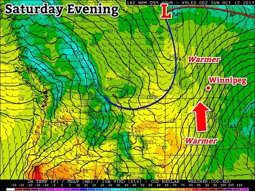
Southern Manitoba will continue to see a gradual improvement temperature-wise, and even start creeping into the above normal temperature range this weekend as a southerly flow kicks in. The one caveat is that winds will be fairly strong on Saturday and Sunday, so hold onto your hats!
Tight gradient between the low over the northern MB/SK border and high pressure to our southeast will make for warm, gusty conditions on Saturday.
Friday
10°C / 2°C
Becoming mainly sunny late in the morning
High pressure to the southeast will make for calm conditions today, with mostly clear conditions and slightly below seasonal temperatures. Throughout the day the ridge will continue to shift eastward, making way for the next system arriving this weekend. With most of the cloud clearing out by late morning, giving way to sunshine it should turn out to be a fairly nice day with a tinge of chill in the air, as temperatures approach the 10°C mark. By the time Friday night rolls around, strong southerly winds will start to pick up as the next low pressure approaches to our north – a tight gradient between the high to our southeast and the low to our northwest will be in place.
Saturday
14°C / 7°C
Starting off sunny, possible afternoon cloud
Saturday looks to start off with plenty of sunshine but the downside will be the windy conditions. Winds will continue to gust throughout the day but temperatures will manage to climb to the low to mid-teens across Southern Manitoba. With that said, there is a chance for some stratus to move in from North Dakota in the early afternoon which means we might not heat out completely. The low Saturday night will be fairly mild thanks to some cloud in the region keeping things warm as well as the southerly flow staying in place – lows will be well above the freezing mark.
Sunday
15°C / 5°C
Mainly cloudy
By Sunday morning winds will have shifted to the northwest due to a cold front sweeping through the region in the morning. Although winds won’t be as strong as Saturday, they will continue to be gusty behind the cold front. Clouds are expected to linger throughout the day but there won’t be any significant precipitation. The temperatures will remain fairly warm, near average values – low teens are expected. Sunday night the low is will drop to the single digits, however, temperatures won’t drop below freezing.
Long Range
The Climate Prediction Centre as well as a few weather models show temperatures staying above normal for a good part of the beginning of next week with another low pressure system making its way across the Prairies and drawing in warm air ahead of it.
Wednesday will be a brief reprieve from the showery weather before a fairly potent low pressure system spreads more rain & thunderstorm activity across Southern Manitoba tonight into tomorrow morning and brings dreary weather for Thursday with strong northwesterly winds.
Wednesday
23°C / 13°C
A few sunny breaks; rain overnight.
Thursday
19°C / 6°C
Rain and drizzle tapering off mid-day. Risk of a thunderstorm. Windy.
Friday
19°C / 5°C
Mainly sunny.
Today will be a fairly pleasant day with mostly cloudy skies and a high near 23°C or so. There’s a slight chance of an isolated shower or three through the Red River Valley, including Winnipeg, but for now it looks like the activity should mainly remain to our west over southern Saskatchewan and southwest Manitoba.
Tonight, an inverted trough extending NW from a low pressure system moving through the Dakotas will spread rain with the risk of thunderstorms eastwards into the Red River Valley. Rain will likely start sometime after 1AM and persist until mid-morning Thursday. The temperature will dip to around 13°C.
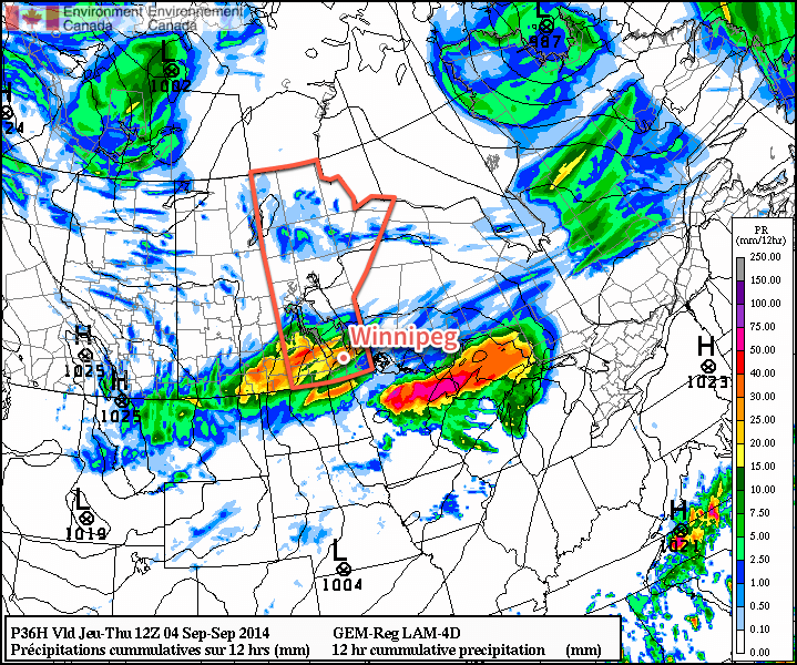
The Canadian RDPS is one of the models rather bullish on higher precipitation amounts Wednesday night.
Rainfall totals for tonight are still uncertain; the general agreement is for between 10–20mm, however if substantial elevated convection develops as much as local amounts of 40–50mm may be possible. The low end of precipitation forecasts produce only around 5mm of rain.
I feel fairly comfortable with 10–20mm of rain tonight, but we’ll reassess the elevated convection potential later today and update if necessary. We’ll try and have an update fairly early this afternoon.
Unpleasant Thursday
Thursday will be quite an unpleasant day as Winnipeg moves onto the back side of the low pressure system lifting northeastwards into Ontario. The bulk of the rain should taper off mid-day, but brisk northwesterly winds building to 30–40km/h will accompany cloudy skies and a high struggling to climb into the upper teens. It’s also fairly likely drizzle will persist after the main area of rain moves out, making for a generally dreary day.
Skies will clear out for the evening, although there may be some cloudy periods through the first half of the night with some cloud moving off of Lake Manitoba, and temperatures will drop to a chilly 5 or 6°C.
Fall-Like Friday
Friday will be fairly pleasant, albeit cool, with mainly sunny skies and a high near 19 or 20°C. Winds will be fairly light through the day.
Friday night should bring clear skies and a low near 5 or 6°C.
A Look Ahead to the Weekend
The upcoming weekend is looking fairly good with unpleasant weather staying to our north. It’s looking like plenty of sun is in store with daytime highs in the ballpark of the seasonal 21°C mark and overnight lows moderating by the end of the weekend.
Southern Manitoba will see its first blast of fall-like weather as gusty northwesterly winds draw cool air southwards over the region. Fortunately, it doesn’t look like the cold weather is here to stay and seasonal temperatures are expected to return by week’s end.
Monday
15°C / 7°C
Mainly cloudy; windy and cool with lake-effect showers possible
Tuesday
19°C / 10°C
Mainly sunny
Wednesday
23°C / 15°C
Mainly sunny
Today will be an unwelcome day for late August as abnormally cold air will move into the province behind the low pressure system that brought 20–40mm of rain to Winnipeg & the Red River Valley Saturday night into Sunday morning. Brisk northwesterly winds to around 30–40km/h will usher in this cooler air and will restrain our daytime high to just the mid-teens. Additionally, the abnormally cool air aloft and favourable wind profiles will combine to produce lake-effect showers that will spread southeastwards towards Winnipeg.
Forecast 850mb temperatures for this afternoon show a trough of cold air anchored over Manitoba.
Given that, occasional showers are likely in Winnipeg although due to the nature of lake-effect precipitation[1] the precise wind direction will determine whether or not the showers find their way into Winnipeg or whether they end up just north or just south of the city.
The clouds will clear out tonight as temperatures drop to around 7°C.
Tuesday and Wednesday will trend towards seasonal weather. Winds will be relatively light both days while the Red River Valley enjoys mainly sunny skies. Temperatures tomorrow will climb into the high teens while highs on Wednesday will reach the low 20’s. Lows on Tuesday night will bottom out around 10°C while Wednesday night sees more seasonal lows in the mid-teens.
Seasonal End to the Week
Looking ahead to the second half of the week, summer weather returns in full swing. Temperatures heading through the end of the week will see daytime highs in the mid–20’s with overnight lows in the mid-teens. The weather looks fairly dry until Friday when a weak cold front pushing across the province brings the chance for some shower or thundershower activity.
Lake-effect precipitation extends in a very narrow band along the direction of the wind. ↩