Major Winter Storm Brewing, Heavy Snow On The Way

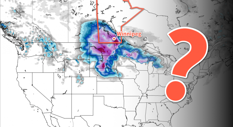
Winnipeg is on track to see an unsettled weekend culminate in a major winter storm as a Colorado Low spreads heavy snow into Manitoba on Sunday night. But the big question remains: how much?

Those hoping that we could escape winter without a major storm this year, brace yourself. It all kicks off today with cloud building through southern Manitoba as a complex storm system begins organizing over the western United States. Temperatures in Winnipeg will be mild with a high near -2°C. Winds will remain light out of the northeast. As some warmer air lifts northwards through the Dakotas towards Manitoba in the evening, it will begin bringing the chance of snow to the region. Temperatures should remain steady near -3°C on Friday night.

The uncertainty begins to ramp up on Saturday with models providing a variety of possible solutions. The general agreement as of writing is that snow will spread across southern Manitoba through the day on Saturday, with more organized snowfall developing on Saturday night. Amounts with this first batch of snow will be limited, with general amounts of 2 to 4 cm forecast on Saturday night. Temperatures will be quite mild on Saturday with a high near +1°C, which means that if precipitation moves into the Red River Valley through the day, some if it may fall as rain. Winds will be out of the east-northeast at 20 to 30 km/h.

NAM forecast simulated reflectivity with precipitation type valid 00Z Sunday March 4, 2018
Snow will be possible across much of southern Manitoba on Saturday as a line of snow lifts northwards.

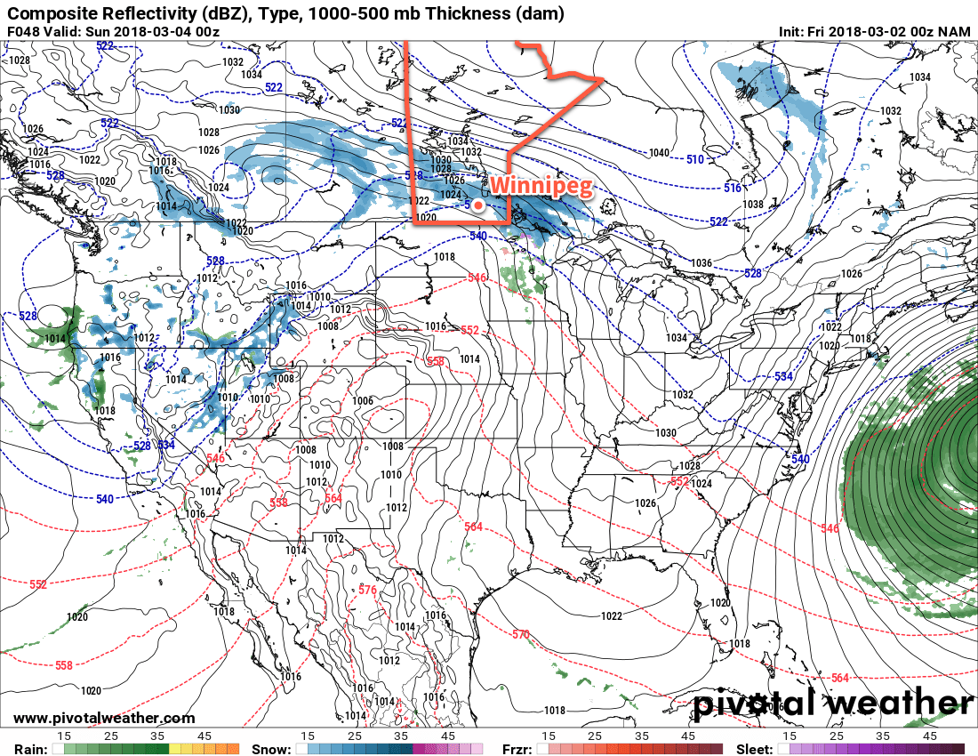
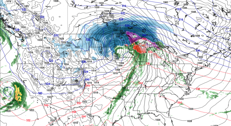
Mild temperatures will continue Sunday with highs once again near 0°C. There will be a slight chance of flurries or drizzle through the day as a Colorado Low begins lifting northwards. Winds will continue out of the north near 30 km/h. The main event is forecast to begin on Sunday evening as heavy snow moves into the province from the south. Unfortunately, there is still quite a bit of uncertainty associated with this, including:

  • Where will the heaviest bands of snow set up?
  • How quickly will this system move?
  • Exactly how intense will the snowfall be?

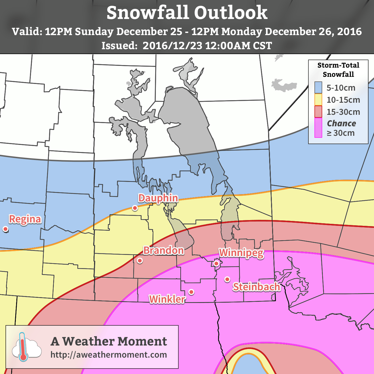
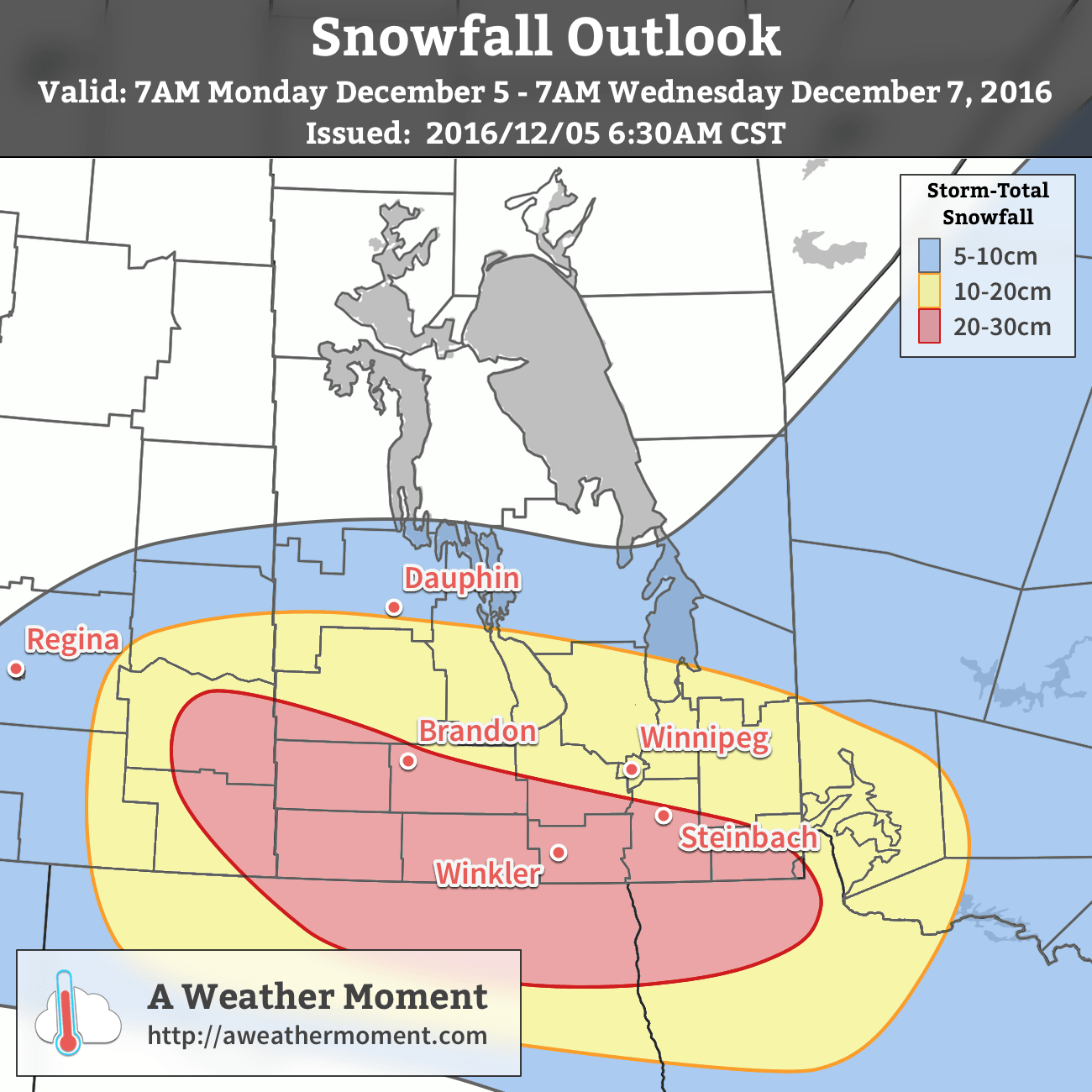
For Sunday night, it looks like the main threat areas are the Red River Valley west towards the Saskatchewan border. There’s a lot of uncertainty with how fast the snow will push northwards, but reaching the Trans-Canada corridor by Monday morning looks likely. The snow will be heavy with the potential for 10 to 20 cm overnight. Winnipeg may escape much of this, instead receiving most of the heavy snow on Monday.

GFS 24 hour snowfall accumulation (at 10:1 SLR) valid 06Z Tuesday March 6, 2018
One potential snowfall outcome has up to 30 cm of snow in the Red River Valley from Sunday night through Monday. But it’s just ? at this point…

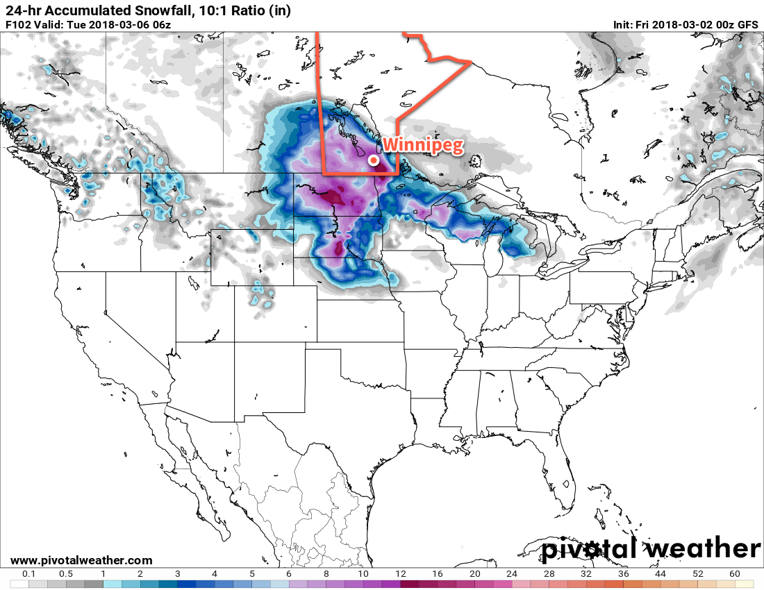
The heavy snow will continue through Monday and then is forecast to taper off Tuesday evening. Storm-total snowfall from Saturday through Monday will likely fall into the 15 to 25 cm range, but there is a small chance of seeing amounts as high as 30 to 40 cm if a worst-case scenario occurs. Either way, it will easily claim the title as worst winter storm so far this year.

Travel Impacts

There will be 3 primary travel impacts from the worst of this storm:

  1. Deteriorating road conditions as snow accumulates.
  2. Reduced visibility in snow and blowing snow.
  3. Snow drifts developing on roadways.

These three elements will be out in full force Sunday night into Monday, and will likely make travel extremely difficult if not impossible. If you currently have travel plans for Sunday night or Monday, it would be a good idea to make a contingency plan and prepare for delays.

Weekend Update

It cannot be understated that the predictability associated with this system is low at this point. We’ll be posting an update or two through the next couple days leading up to the event with updated forecast information, so stay tuned.

Winnipeg’s seasonal daytime high is currently -5°C while the seasonal overnight low is -15°C.

Early Taste of Spring Continues, Winter Storm Looms on Horizon

Winnipeg will see March will kick off the same way February ends: with high temperatures near 0°C bringing an early taste of spring to the region.

The mild weather Winnipeg has seen over the past couple days isn’t going anywhere. A mild Pacific flow will continue through the rest of the work week, bringing near-freezing highs to the region. Tonight and Thursday night will both see overnight lows near -10°C.

GDPS 2m Temperature Anomaly valid 00Z Friday March 2, 2018
Much of Manitoba will see above-normal temperatures on Thursday, shown here by the areas shaded red

Winnipeg will see plenty of sun as well. A few clouds will move through the Red River Valley today, but then mainly sunny skies will be in place through Thursday and much of Friday. Some cloud will begin moving into the region late Friday ahead of a low pressure complex organizing in the United States. The cloud cover will keep Friday night’s low warmer, only dipping down to around -3°C.

Long Range Outlook – Winter Storm Brewing

The weather will turn more unsettled for the weekend as a series of low pressure systems move through the region. Mild temperatures will continue in Winnipeg, but cloudy skies will persist through the weekend into the first half of next week.

There will be a couple of chances for snow – or even a rain shower – through the weekend. Come Sunday night through Monday, what may end up as the biggest storm thus far in the 2017/18 winter season moves through. While it’s too early to put much trust in any of the forecasts, some guidance suggests Winnipeg and the Red River Valley may see over 25 cm of snow with this storm system.

GDPS 850mb Temperature Forecast valid 12Z Monday March 5, 2018
A complex, slow-moving low pressure system may bring Winnipeg the biggest winter storm of the 2017/18 season on Sunday night into Monday.

For now, just keep it in mind that there is the chance for a major snow storm to start next week. If you have travel plans involving driving on Monday, consider contingency plans just in case.

Until then, enjoy the beautiful sunshine and mild temperatures!

Winnipeg’s seasonal daytime high is currently -5°C while the seasonal overnight low is -15°C.

Winnipeg Set To Receive A Blizzard for Christmas

The consensus is in: it seems overwhelmingly likely that Winnipeg will see a major winter storm bringing significant snow and blizzard conditions beginning midday on Christmas Day and persisting through Boxing Day.

The Lead-Up

Today and tomorrow will both be fairly benign days. Today will bring above-normal temperatures with a high near -4°C and light winds. A bit of cloud will be around but it should be a fairly sunny day overall. A weak cold front will swing through late this afternoon, bringing in northwesterly winds to around 20 km/h and cooler temperatures. The low tonight will drop to about -15°C with increasing cloud.

Tomorrow will be a mainly cloudy day with a much cooler high temperature near -12°C behind that cold front. Winds will continue out of the north to northeast at around 20 km/h. Temperatures will drop to a low near -15°C once agin on Saturday night with a good chance of light snow spreading into the Red River Valley from the southwest through the second half of the night.

Major Winter Storm For Christmas

The major story here is the significant winter storm set to impact Southern Manitoba on Christmas Day.

The system is currently develop off the western coast of North America. This satellite animation, taken from midnight last night, shows the long-wave trough that will evolve into a major winter storm beginning to dig southwards as it approaches the western United States. At this point, it looks like snow will intensify through the day on Sunday, with the most potent part of the storm impacting the Red River Valley roughly from 12PM Christmas Day through 12PM Boxing Day.

If you have travel plans for Christmas Day or Boxing Day, this storm will almost certainly disrupt them.

Christmas Day will start with some light snow over the Red River Valley that will intensify rapidly midday as a very potent low pressure system lifts northwards into North Dakota & Minnesota. The heaviest snow will move in by Sunday evening and persist until late Monday morning. By all indications, the snow will be relentless on Sunday night with rapid accumulations. Through this period, the wind will also be increasing out of the northeast to 40-50 km/h. The heavy snow overnight combined with strong winds will produce blizzard conditions through the Red River Valley with zero or near-zero visibilities. There is a high likelihood that most highways will be closed through the night.

The wind and snow will taper off on Monday. Fortunately, without a potent high pressure system building in from the northwest, a weak trough line hanging back across the province from the low will break up the strong winds. This should limit the period of worst travel conditions, with it seeming likely that by Monday afternoon highway travel will be possible again, although likely still slow.

AWM Snowfall Outlook for December 25-26, 2016

When all is said and done, the snowfall from this system should be quite impressive. Widespread amounts of 15-30 cm will be seen across the region, with areas south of a line running roughly from Pilot Mound through Winnipeg and Pinawa having the chance of seeing snowfall totals creep above 30 cm. At this point it looks like 30-35 cm would be the upper end of the potential snowfall totals, but there is high confidence in amounts of 20-30 cm.

Light snow and flurries may linger through the remainder of boxing day before gradually tapering off overnight or early on the 27th.

Winnipeg’s seasonal daytime high is currently -12°C while the seasonal overnight low is -22°C.

Major Winter Storm Moving In

Environment Canada has issued a Winter Storm Warning for this system.

A major winter storm is moving in as you read this article. It will bring the first serious snowfall of the year to the Red River Valley, with heavy blowing snow or even blizzard conditions possible in many areas. You may want to reconsider any travel plans early this week!

A strong low pressure system will bring heavy snow and strong winds to southern Manitoba early this week

Today

Monday
0°C / -2°C
Snow beginning

A strong low pressure system will move off the Rocky Mountains and into North Dakota today. It will spread moderate to heavy snowfall into parts of western Manitoba this morning, before snow spreads over the rest of southern Manitoba later in the day. Snowfall will fall for the entire day in most of western Manitoba, with total accumulations of 10-15 cm expected in most areas. Further east, the Red River Valley will see lesser amounts today, with 2-5 cm in the Winnipeg area and more like 5-10 cm near the International border. Local amounts of 15 cm may occur along the International border in south-central Manitoba. Winds will be gusty from the east at 20-30 km/h, producing some blowing and drifting snow.

Tuesday

Tuesday
-2°C / -4°C
Blizzard Developing with Heavy Snow

Conditions will really begin to deteriorate early Tuesday as winds shift to the northwest. Snow will continue to fall as well, with an additional 10-20 cm possible in the Red River Valley on Tuesday. Snow will taper off in southwestern Manitoba, but another 2-5 cm will be possible. The northwesterly winds that develop will be strong at 40 km/h gusting to 60 km/h, with higher values of 50 km/h gusting to 70 km/h in some treeless areas. This will likely result in blizzard conditions over large parts of southern Manitoba, especially south and west of Winnipeg. Those areas that don’t quite meet blizzard criteria will certainly see heavy blowing and drifting snow, with travel becoming difficult or impossible in some areas. Road closures are likely, especially the Trans-Canada Highway west of Winnipeg and Highway 75 south of Winnipeg. Conditions will not improve significantly until early Wednesday.

Expect storm-total snowfall accumulations by Wednesday morning.

Wednesday

Wednesday
-12°C / -20°C
Snow and blizzard ending

Snow should finally taper off on Wednesday morning in all of southern Manitoba, but not until most areas have received significant accumulations of snow. Southwestern Manitoba can expect 15-25 cm, while Winnipeg can expect 10-20 cm. Areas along the International border in south-central Manitoba can expect to receive 20-30 cm. Locally higher amounts may occur where heavier bands of snow persist for a longer period of time. Large snow drifts will be a problem on Wednesday, even once the snow ends. Some rural roads may be impassable due to heavy drifting. Blowing snow will persist on Wednesday, but winds will slowly decrease throughout the day. Temperatures will have dropped noticeably on Wednesday as this system begins to pull down a cold arctic air mass.

Long Range

Conditions will finally calm down on Thursday as winds taper off. However, in the wake of this strong low we’ll see a blast of arctic air, with temperatures likely dropping into the minus twenties on Thursday and Friday. This frigid pattern is expected to persist for awhile, so make sure to get out those winter clothes!