Elsewhere in Weather News: November 30th, 2013

Cyclone Lehar Hits India

This past week a weak cyclone hit India’s east coast as a weak cyclone depression. The cyclone – Cyclone Lehar was classified as a severe cyclone in the Bay of Bengal with winds over 100km/h but has since been downgraded. Unfavorable sea surface temperatures and shear for storm development did a good job on tearing up the storm apart before landfall. The storm made landfall as a tropical depression on Thursday, with winds of 60-70km/h at landfall. Evacuation precautions were taken by the India Meteorological Department because of the strength of the cyclone while it was over the Bay of Bengal but the only real threat that Lehar brought was flood threat. No significant damage was reported from the storm but some crops have been damaged and a few districts vulnerable to flooding in India’s Andhra Pradesh state have been affected by flooding.


Cyclone Lehar as it was struggling to organize over the Bay of Bengal. (Source: NDTV)

Arctic air dominated over a good part of both Europe and the United States this week which brought minimal significant weather to the regions. Apart from significant snowfall associated with a trough of low pressure affecting the eastern seaboard of the United States earlier this week, active weather has been kept to a minimum. The next big weather event is likely to be a winter storm which will affect the northern states (MT, ND) and even southern Manitoba on Tuesday and Wednesday of next week.

Winter Storm on the Way; Spring Still M.I.A.

Yet more winter weather is in store for Winnipeg as we remain stuck on the cold side of the jet stream while the main storm track through the Northern Plains of the United States becomes more active. While weather will remain relatively benign through today and tomorrow, things will become more active on Sunday and persist through much of next week.

Friday and Saturday

Friday

2°C / -9°C
Chance of scattered flurries this morning. Becoming a mix of sun and cloud.

We’ll see the chance of some scattered flurries through the Red River Valley this morning as a weak trough hangs back into Southern Manitoba from the low pressure system walloping Southern Ontario. Any snow that falls will be light and non-accumulating. Through the day the skies will break up a bit and we’ll end up under a mix of sun and clouds with a high near 2°C here in the city and closer to -1 or 0°C elsewhere in the Red River Valley. Tonight we’ll see partly cloud skies with temperatures dropping to around -8 or -9°.

Saturday

4°C / -7°C
Mostly sunny.

On Saturday, we’ll see fairly sunny skies with the warmest temperatures we’ve seen in a while1 as our daytime high rockets all the way to a balmy 3 or 4°C! Winds will remain relatively light out of the northeast throughout the day. Clouds will begin to move in through the overnight period in advance of the next weather system as we drop to around -7 or -8°C.

Sunday into Monday

Sunday

3°C / -4°C
Cloudy. Slight chance of showers or flurries in the afternoon. Snow beginning overnight.

Here comes winter. A major storm system will push out of Wyoming through South Dakota on Saturday night and into central North Dakota through the day on Sunday. Convection will fire up to the east of the low which will supply moisture that will wrap northwards and westwards through an area of strong lift on the north side of the low. This area of precipitation will push northwards through N. Dakota into Southern Manitoba pushing northwards to Winnipeg by Sunday evening. Light snow will begin overnight as winds strengthen out of the north.

GDPS 12hr. precipitation forecast with surface pressure.

GDPS 12hr. precipitation forecast with surface pressure.

By Monday morning the low pressure system is forecast to be near Lake-of-the-Woods with a strong pressure gradient situated over the Red River Valley. Snow will be wrapping around the back side of this system into the valley while strong northerly winds of 40-50km/h help blow it around. Temperatures will, fortunately, be near the freezing mark, but with the strong winds and damp air it will feel quite cool.

The system should leave the region overnight Monday with a cool, benign weather pattern settling in once again.


  1. It’s rather depressing that +3°C can possibly be the warmest temperatures we’ve had in a while when it’s mid-April. 

Major Winter Storm to Start the Week

A major winter storm will impact all of Southern Manitoba to start the week. Accumulations will be very heavy in some areas, but luckily this won’t be another blizzard.

image

Weather Conditions at 12pm on Monday (GEM-Regional)

A developing low pressure system currently located in south-western Saskatchewan will be responsible for the snow. This system was formed as a powerful upper-level disturbance moved onshore in British Columbia late last night. This disturbance continues to track across the Prairies and will provide the lift necessary to generate the snow.

The snow has already begun to fall in south-western Manitoba this evening. Bands of moderate to heavy snow have been falling just south-west of Brandon. Heavy snow will continue to develop in this region as the evening progresses. Further east in the Red River Valley snow will begin to fall gradually this evening, with heavier bands moving in overnight. By Monday morning all of Southern Manitoba will be in the snow. It is expected that the heaviest snow will fall mainly south and west of Winnipeg, particularly along the international border, though the city will see decent accumulations as well. The following graphic shows our snowfall forecast for Southern Manitoba:

image

Snowfall totals by Tuesday morning across Southern Manitoba.

The wind through this event won’t be particularly strong, with speeds of 20-30km/h gusting to 40-50km/h expected during the day on Monday. This will cause some blowing and drifting snow on the highways, but within urban areas the wind won’t be a significant factor. Temperatures through the day on Monday will be fairly steady in the mid to upper minus single digits, so the wind chill won’t be very high either. The snow will taper off on Tuesday night, with only lingering flurries expected by daybreak on Tuesday.

Tuesday will see our weather begin to settle down as the storm departs. As mentioned above, we may see a few flurries during the day on Tuesday, but additional accumulations will be small. Temperatures won’t drop off much, with highs once again in the mid to upper single digits.

Wednesday will again be a rather unexciting day weather-wise. Temperatures will be in the mid to upper minus single digits with a brisk south-easterly wind.

Major Winter Storm Ushers in Winter

A major Colorado low will bring an end to fall and transform our dry, dusty landscape into a winter wonderland this weekend. This storm will have major impacts on Southern Manitoba with heavy snow producing rapid accumulations and moderate strength winds producing low visibilities and drifting snow.

Satellite Image from 9PM Yesterday

Satellite image from 9PM last night showing location of the main low (marked by the large L) and the area of snow already developed out ahead of it.

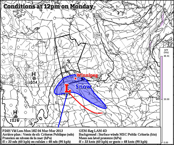
Snow will push into southwestern Manitoba this evening as a band of snow that has produced 10-20cm of snow in Southern Saskatchewan spreads eastwards into Manitoba. This snow will intensify over the SW portion of the province overnight and slowly spread eastwards. By tomorrow morning, snow should have pushed across all of southern Manitoba, with light snow falling over the RRV and Whiteshell.

On Saturday, the main low centre associated with this system will push into Minnesota, and things really start to fire up. A surge of moisture will wrap around the north side of this system back into Southern Manitoba resulting in heavy snowfall over the Red River Valley and Whiteshell.

Total QPF

Total QPF amounts (liquid equivalent precipitation) by Sunday morning.

The GEM-GLB model is beginning to have a fairly decent handle on things, however it’s track is likely a little too far south. Amounts seem fairly believable, though, which means widespread accumulations of 15-20cm of snow for all areas south of the Trans-Canada Highway. An axis of heavier snow will exist, likely from near the Pilot Mound region extending NE through (or just south of) Winnipeg and towards Bisset, where amounts will likely end up closer to 20-25cm.

There’s some indications that convective banded precipitation may develop as well; should this happen, there would likely be areas in the Red River Valley (too hard to say exactly where at this time) that could potentially see 30cm+ of snow (that’s a foot if you prefer those imperial measurements).

Winds will remain moderate, only around 30km/h with gusts to 50km/h, however with the intensity of the snowfall, there will likely be periods of near-zero visibility. It’s also very likely that roads will quickly become snow- and ice-covered, with some drifts developing over highways in open areas. Travel will be extremely treacherous on Saturday, and highway conditions will likely not improve until crews have been able to get out and start clearing things on Sunday.

If you have travel plans on Manitoba highways for this weekend, it is important to note that 10-20cm of snow will fall across much of Southern Saskatchewan today. Through yesterday and by the end of today, up to 2 feet of snow will have fallen through central and eastern Montana, and conditions will be equally poor in North Dakota today and tomorrow. This storm will be arriving a little later in NW Ontario, with the precipitation (likely with an area of freezing rain) arriving Saturday morning instead of Friday evening. More or less, unless you’re driving north, you’ll likely be hitting challenging road conditions no matter where you’re headed this weekend. If you do need to travel in a winter storm, make sure you carry a winter survival kit in your vehicle.