
Widespread smoke will remain in place today as a northwesterly flow gradually lightens and leaves the smoke to languish across Southern Manitoba. A low pressure system tracking into the northern Prairies tonight will bring a southerly flow at all levels to Southern Manitoba which will help clear skies out as well as lead towards an unsettled end to the weekend.
Today will bring partly cloudy skies which will seem a whole lot cloudier thanks to the widespread smoke that remains entrenched over Southern Manitoba today. That smoke will keep our temperatures slightly cooler than they would be under clear skies, leaving us with a high temperature later today of 26°C. Winds will remain fairly light through the day. The humidity will be more comfortable than yesterday’s dew points of 20°C; dew point values are expected to sit in the low- to mid-teens this afternoon.
Winds will begin picking up out of the south overnight which should help begin clearing the smoke out of our area. Our temperature will dip down to around 17°C.
Saturday will bring the humidity back to Southern Manitoba alongside gusty southerly winds to 30–40km/h. It will be quite a warm day with temperatures soaring into the upper–20’s or even hitting the 30°C mark while dew point values climb back towards the 20°C mark as the southerlies bring in more humid air from the Northern Plains.
Saturday night will see thunderstorms initiate over Western Manitoba then slowly push southeastwards. There will likely be a chance for some severe thunderstorm activity over Parkland Manitoba; we’ll take a closer look and issue a convective outlook if warranted tomorrow. These showers and thunderstorms will slowly stall out towards the Red River Valley near morning and then sit over the region for much of Sunday. Temperatures will climb to a very humid 23°C or so on Sunday before the cold front finishes pushing through.
Behind the cold front, cooler and less humid air will begin working back into Manitoba. Sunday night will see the coolest overnight low in a while as it dips towards the low teens. With that cooler, drier air will come a northwesterly flow which will likely mean a return to smokier conditions.
A slight risk of severe thunderstorms exist today from extreme SE Saskatchewan northeastwards through Parkland Manitoba into the Interlake region and then extending southwards into North Dakota.
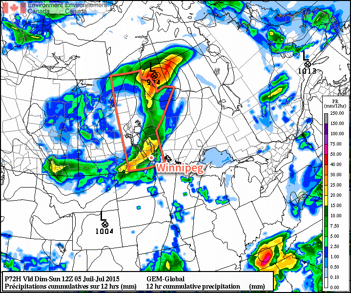
A cold front slumping southwards through Manitoba today will be the trigger for thunderstorms this afternoon. MLCAPE values of 1500 – 2000 J/kg will combine with 20-25 kt of bulk shear to bring the risk of severe thunderstorms across two modes today. Initially, storms are likely to develop as isolated supercell storms capable of all modes of severe weather (torrential rain, large hail, damaging winds, small tornado risk), but as the day/evening pushes on, storms will likely expand in coverage and become more of a squall line pushing southwards. With winds aligned roughly parallel to the front, the line will move fairly slowly and training thunderstorms may become an issue. Training thunderstorms are when multiple thunderstorms pass over the same region. This dramatically heightens the heavy rainfall threat and makes flash flooding much more likely.
The general progression expected is that thunderstorms will initiate along the cold front in the western extent of the slight risk area and then slowly push south-southeast towards the Red River Valley, expanding in coverage as they do so. They’ll push into Winnipeg this evening and persist for quite a while due to the slow motion of the line. Be sure to get those downspouts down and be prepared for the potential of a lot of water.
During daytime hours the storms will be capable of all modes of severe weather, although the tornado threat will be somewhat diminished due to a variety of not-quite-favourable parameters (remember that all supercell thunderstorms are capable of producing thunderstorms, though). Into the evening/overnight period, the threat will likely shift towards rain and hail.
I’ll be gone much of today, but if able I’ll post more updates later today. Stay safe!