Winnipeg and the Red River Valley will see one more day of wet weather before a shift in the large-scale pattern finally returns some sunshine to the region. The initial cost will be some cool weather, but a decent blast of warmer weather should move in for Sunday!
The nearly 2 weeks of cloudy weather will continue today thanks to another disturbance rippling through the region in the northwest flow that has set up over the region. Rainfall will be fairly light today, coming from scattered showers beginning mid-day and lasting through the afternoon rather than any organized, large area of rain. Alongside the rain will be west to northwesterly winds in the 15–25km/h range with perhaps a bit of gustiness on top of that through the afternoon hours.
Winds will shift to be more westerly tonight, leading to a cooler overnight low than we’ve seen lately; the more westerly component to the wind will mitigate the warming effect the lakes can have on us at this time of year and allow cooler air to push into the Red River Valley. Thanks to that, temperatures will drop to around the –2°C mark tonight under mostly cloudy skies.
Sun Reappears Saturday
Saturday will bring an end to the persistent cloud that has blanketed the region for nearly two weeks as the dominant flow shifts to be more southwesterly, bringing drier air through the low-levels into Southern Manitoba. There will likely be a fair amount of cloud in the Red River Valley in the morning, but the winds will pick up to 20–30km/h through the morning and the cloud cover should push out of the region through the afternoon, leaving us with a sunny end of the day. There’s uncertainty as to exactly how long the cloud will stick around on Saturday; models tend to be too quick on moving cloud out of the Red River Valley, but it seems a safe bet that by the end of the afternoon, the sun will be shining.
Some of the clearing will be facilitated by a ridge of high pressure moving through the region; thanks to that, our daytime high will be limited to just a couple degrees above freezing. Fortunately, a warm front will push through overnight and keep overnight lows seasonably mild and near the freezing mark.
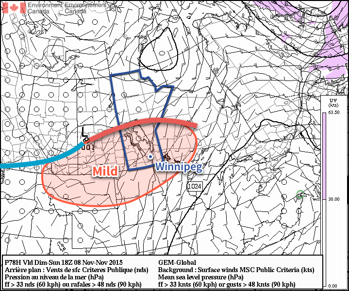
Sunday will be a beautiful day. With Winnipeg & the Red River Valley firmly entrenched in the warm sector of the low pressure system passing to our north, temperatures will climb to around the 10°C mark with winds out of the south at around 20km/h. There really won’t be anything to complain about!
Pleasant Weather to Start Next Week; Chance of Snow Mid-Week
The pleasant weather will persist into the beginning of next week with seasonal to slightly above-seasonal temperatures continuing and no precipitation expected. A mid-week cool down is possible, though, and with it may come the first snowfall of the season for Winnipeg; at this point we’ll just have to wait and see how things develop.
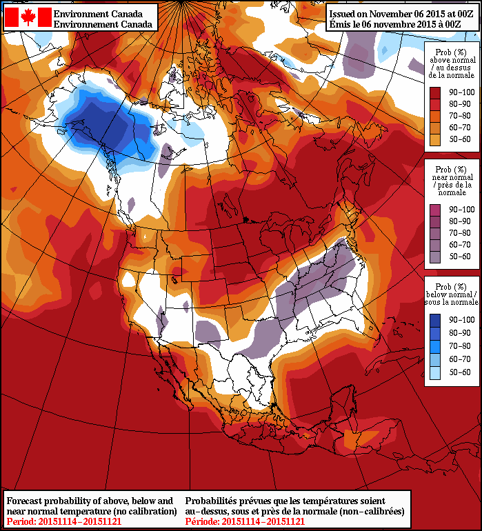
In the long-range, the broken record continues and generally warmer-than-seasonal temperatures are expected. As the NAEFS shows in the image above, for the 8–14 day forecast range—the end of next week into the week after it—there’s a very high likelihood of above-seasonal temperatures. This doesn’t mean that the temperatures will consistently be above seasonal and cold weather isn’t possible; rather that, overall, conditions will average out to warmer than seasonal.
Given that November has been off to far worse starts than the green grass and late-season golfing of this year, other than the lack of sunshine[1] one can’t really complain too much! Unless you really like the cold and snow.
Enjoy the weekend and we’ll be back bright and early Monday morning with your forecast to start off next week!
- The persistent cloud cover has also been partly responsible for the continued warmth in the region, so there’s that… ↩