Plenty of cloud and snow is in the forecast as one low pressure system leaves only to be quickly replaced by another mid-week. Temperatures will also remain cool as a large upper trough keeps the jet stream south and allows cooler Arctic air to spill into the Prairies.
Today will bring mainly cloudy skies to the region as a low pressure system that tracked through the region on Sunday pushes off into eastern Ontario. To start off the morning, widespread flurries in place across the region will taper off as a strong northerly wind of 40-50 km/h develops. Snow will taper off by midday for many locations except for two: those in the lee of Lake Manitoba and Lake Winnipeg.
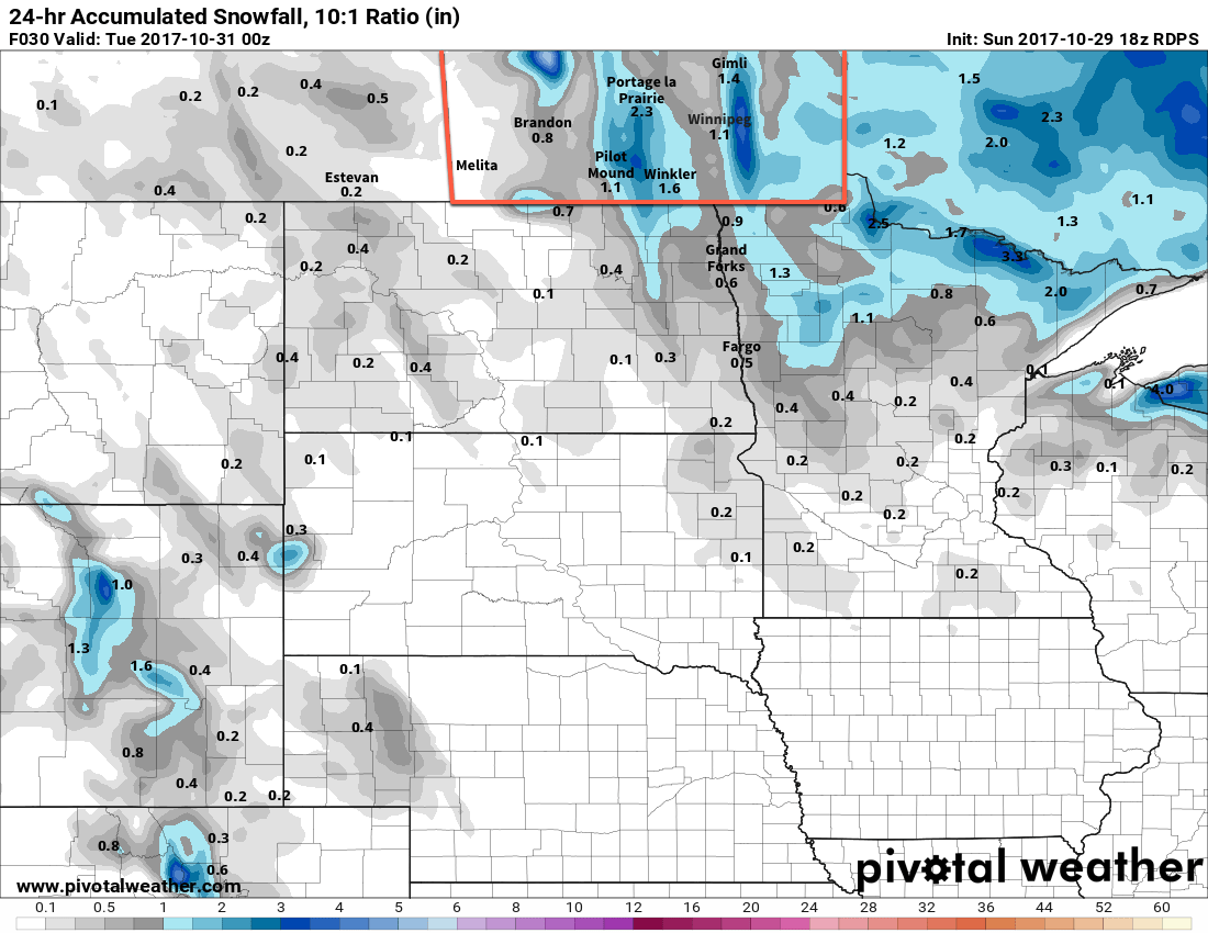
Strong northerly winds align along the basins of each lake this morning and persist all day, and as the colder air moves into the region, bands of lake-effect snow will develop and move southwards off the lake. The areas highlighted in the area above are the most likely to see snow and significant accumulating snow. Snowfall accumulations can be difficult to forecast in these events, but indications are that as much as 10 to 20 cm may fall by the end of the day under the heaviest band of snow. The Lake Manitoba event will taper off in the early evening as a ridge of high pressure moves in and eases the winds, while Lake Winnipeg will persist longer, weakening in the evening and ending overnight.
Aside from the snow, it will be a cool day whose high near -1°C will feel closer to -8 or -9°C with the strong northerly wind. Once the ridge moves into the area in the evening, winds will taper off and temperatures will head towards a low near -8°C under mixed skies.
Tuesday will bring benign weather to the region with mixed skies and temperatures climbing back to a high near -1°C. Winds will pick up out of the south through the morning hours, strengthening to 25 to 35 km/h for the afternoon hours. By evening, more cloud will be spreading across southern Manitoba in advance of the next low pressure system as it tracks across Saskatchewan. The cloud will keep temperatures a bit warmer overnight with lows of around -3°C. Winds will continue out of the southeast at around 20 to 30 km/h.
Wednesday will see the low and its associated area of snow move through the province. In the Red River Valley, snow will begin early in the morning and persist into the evening. As is the case with these early season events, the biggest challenge with this system will be the near-zero temperatures with daytime highs climbing to around 0 or +1°C and how that will affect how much snow accumulates versus melts. The expected snowfall is around 4 to 8 cm, but the actual accumulated amount will be less than that, with roadways likely ending up with a slushy centimetre or two by the end of the day, and grassy areas seeing closer to, but not the full, amount that falls.
Fortunately, winds will taper off in the morning, so visibilities will be as good as they can be with the snow falling. The wind will pick up out of the north in the afternoon into the 20 to 30 km/h range. The cloud cover will likely remain through the night with the potential for a bit of lake-enhanced/effect snow coming off of Lake Manitoba and Winnipeg. Temperatures will dip to a low near -6°C.
The only real uncertainty with this system is how far south it will end up going, and whether or not it will end up too far south to impact our region. The general consensus is that Winnipeg and the Red River Valley will see snow, but we’ll be keeping an eye on how it develops just in case.
Long Range
The remainder of the week doesn’t look much better; Thursday will see any remaining flurries taper off with a continued north wind that makes the high near -1°C feel rather cool. Temperatures will then dip down to the low minus single digits on Thursday night and rebound to just -2 or -3°C on Friday under mostly cloudy skies. Another cold night on Friday night will lead into highs returning to the freezing mark on the weekend, but that’s due to the approach of a mother system that will bring another wintery mix to the region late Saturday into Sunday.
Once that passes by, a significant chill will descend across the Prairies, bringing below-normal temperatures for an extended period, alongside the potential for more snowy weather.
Winnipeg’s seasonal daytime high is currently 4°C while the seasonal overnight low is -5°C.