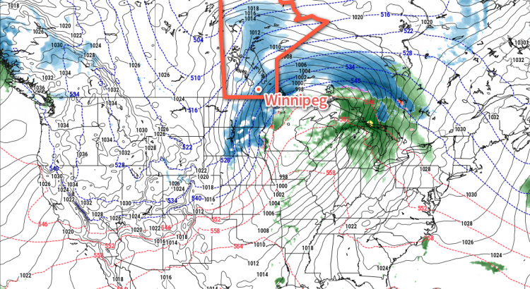
As we mentioned in Friday’s forecast post, a major change in the weather is on the way as a potent low pressure system develops in the United States. What Winnipeg can expect to see has become more clear over the past 24 hours, and it looks like the city will see a fresh coat of snow before strong northwesterly winds plunge temperatures well below the values seen over the past week.
Winnipeg will see skies cloud over through the day today, thickening up as the low pressure system in the American Plains spreads cloud northeastwards. Temperatures will reach a high near -1 or 0°C with light winds.
Heading into the evening, snow will spread eastwards across southern Manitoba, slowly intensifying as it pushes towards the Ontario border. For Winnipeg and the Red River Valley, snow will begin in earnest sometime late in the evening and persist for around 6 hours before easing so light snow or flurries. Snowfall amounts will likely end up between 4 and 8 cm…assuming nothing goes to awry with the forecast. To that end, there’s a little bit of disagreement in how the models handle the precipitation; some support it all as a single blob that moves through the region, but others have some along a narrow secondary band that dies out towards the Red River Valley, and more associated with the low pressure system as it lifts northwards out of the United States. Should that second outcome occur, Winnipeg would likely see less snow overall. The other potential problem, particularly for areas close to the US border, is that slightly above-zero temperatures may end up resulting in part of the precipitation falling as rain, which would also [obviously] lead to reduced snowfall amounts.
Monday will bring strengthening northwesterly winds to Winnipeg as colder air begins pushing into the region on the back-side of the low. By Monday afternoon, Winnipeg will see winds of 40-50 km/h out the northwest as temperatures fall towards -6°C. The strong winds will combine with the fresh snow, and possibly some still falling light snow, to produce areas blowing snow.
Much cooler weather is on the way for the remainder of the week, with daytime highs falling into the -10 to -15°C range. We’ll have more details on the upcoming week bring and earlier at the usual time on Monday morning! And stay tuned to our Facebook and Twitter feeds this evening for updates as this system finally begins taking shape!

